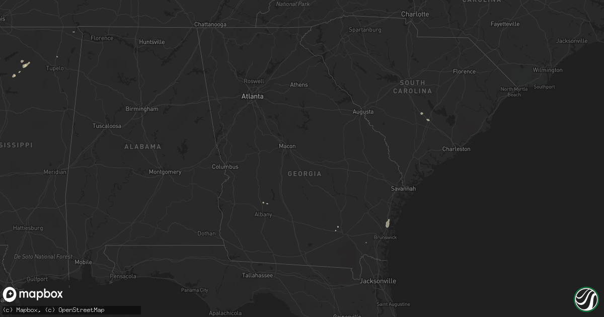
Hail Map in Georgia on June 4, 2013
Get this storm
June 4 map
$229
one time, instant access
Download today. No call, no setup
Keep the $229
Bought the map and want the full workflow? Apply the entire $229 to a subscription within 7 days. None of it is wasted.
Every map, not just this one
This buys you this map. Subscription and you get every map we run, in the markets you choose from a few cities to whole states to nationwide. Plus real-time alerts the moment a storm fires.
Contact data
Name, contact info, occupancy, even credit band for addresses in the footprint. You go from where it hit to who to call.
Become the source they trust
Unlimited branding weather history reports on demand. You already have the documented answer ready for the property owner, and you are the one who showed up with it.
Property data and RoofTrace estimates
Pull up any address you have got, its value and the exact code rules for that jurisdiction, straight from One Click Code. Then RoofTrace estimates the squares, pitch, and roof value, priced the way you price.
Storm reports in Georgia
Georgia
| Date | Description |
|---|---|
| 06/04/20136:15 PM CDT | Broadcast media relayed a public report of a large pecan tree that was downed in dixie union. Time was estimated based on radar imagery. |
| 06/04/20133:50 PM CDT | Liberty 911 center reported a large tree limb down on a power line blocking wilson ave near n main st. |
| 06/04/20132:40 PM CDT | Long mcintosh 911 reported trees down on murray townsend rd at hwy 99. |
| 06/04/20132:30 PM CDT | Jenkins emergency dispatch reported a tree down on highway 23 s in butts. |
| 06/04/20132:19 PM CDT | Mcintosh county reported several trees down near cypress street in darien. |
| 06/04/20131:44 PM CDT | Media in savannah reported the left lane of interstate 16 west at interstate 516 was blocked due to a fallen tree. Time estimated by radar. |
| 06/04/20131:41 PM CDT | Chatham emergency management reported trees down at liberty pkwy and acl blvd. |
| 06/04/20131:41 PM CDT | Chatham emergency management reported trees down at chatham center dr. |
| 06/04/20131:40 PM CDT | Spotter reported estimated wind gust to 60 mph. |
| 06/04/20131:20 PM CDT | Long mcintosh 911 reported trees down on harris neck rd at eagle neck airport. |
| 06/04/201312:38 PM CDT | Liberty county reported a tree down on camp viking road. Time estimated by radar. |
All States Impacted by Hail Map on June 4, 2013
Cities Impacted by Hail Map on June 4, 2013
- Leoti, KS
- Boise City, OK
- Marathon, TX
- Healdton, OK
- Pritchett, CO
- Karval, CO
- Ordway, CO
- Sugar City, CO
- Keyes, OK
- Texhoma, OK
- Merkel, TX
- Trent, TX
- Lakin, KS
- Syracuse, KS
- Halstead, KS
- Dorchester, NE
- Crete, NE
- Billings, OK
- Satanta, KS
- Sylvan Grove, KS
- Wilson, KS
- Guymon, OK
- Texhoma, TX
- Stratford, TX
- Spearman, TX
- Goodwell, OK
- Gruver, TX
- Oswego, KS
- Wilson, OK
- Ardmore, OK
- Follett, TX
- Booker, TX
- Perryton, TX
- Balko, OK
- Hardesty, OK
- Darrouzett, TX
- Dexter, KS
- Scott City, KS
- Burlington, OK
- Las Animas, CO
- Kim, CO
- Springfield, CO
- Haswell, CO
- Eads, CO
- Fort Stockton, TX
- Tribune, KS
- Osborne, KS
- Hugoton, KS
- Rolla, KS
- Tecumseh, OK
- Norman, OK
- Baldwyn, MS
- Wanette, OK
- Macomb, OK
- Asher, OK
- Lawton, OK
- Minneola, KS
- Ford, KS
- Dodge City, KS
- Burnsville, MS
- Madill, OK
- Marietta, OK
- Ringling, OK
- Nicholls, GA
- Assaria, KS
- Englewood, KS
- Alva, OK
- Davis, OK
- Cherokee, OK
- Carmen, OK
- Dacoma, OK
- Helena, OK
- Hamlin, TX
- Lake Park, MN
- Marienthal, KS
- Lamont, OK
- Hunter, OK
- Wilsey, KS
- Burdick, KS
- Council Grove, KS
- Dalhart, TX
- Arnett, OK
- Leedey, OK
- Oakley, KS
- Campo, CO
- McCaulley, TX
- Abilene, TX
- Ringwood, OK
- Anton, CO
- Cope, CO
- Taloga, OK
- Sylvester, TX
- Pawhuska, OK
- Sterling, KS
- Anadarko, OK
- Verden, OK
- Pond Creek, OK
- Bailey, CO
- Montezuma, KS
- Gate, OK
- Wynnewood, OK
- Pauls Valley, OK
- Bartlesville, OK
- Nowata, OK
- Winfield, KS
- Sedalia, CO
- Watonga, OK
- Wallace, KS
- Howard, KS
- Longton, KS
- El Reno, OK
- Red Rock, OK
- Anson, TX
- Sweetwater, TX
- Overbrook, OK
- Kingston, OK
- Seibert, CO
- Flagler, CO
- Lookeba, OK
- Welch, OK
- Stockton, KS
- Manchester, OK
- Wakita, OK
- Sublette, KS
- Buffalo, OK
- Healy, KS
- Hooker, OK
- Ashland, KS
- Dent, MN
- Richville, MN
- Springer, OK
- Tonkawa, OK
- Greenfield, OK
- Geary, OK
- Wellington, KS
- Felt, OK
- Thackerville, OK
- Waynoka, OK
- Union City, OK
- Yukon, OK
- Ulysses, KS
- Ponca City, OK
- Minco, OK
- Binger, OK
- Glenwood, MN
- Weinert, TX
- Oklahoma City, OK
- Claflin, KS
- Hoisington, KS
- Water Valley, MS
- Shattuck, OK
- Apache, OK
- Cyril, OK
- Fowler, KS
- Paris, MS
- Whitewright, TX
- Liberal, KS
- Chester, OK
- Walters, OK
- Columbus, KS
- Ravenna, TX
- Savoy, TX
- Lincolnville, KS
- Marion, KS
- Crawford, OK
- Beloit, KS
- Essex, IA
- Shenandoah, IA
- Turpin, OK
- Vona, CO
- Gracemont, OK
- Elgin, OK
- Fletcher, OK
- Rush, CO
- Kendall, KS
- Ninnekah, OK
- Coin, IA
- Lincoln, KS
- Ramah, CO
- Perry, OK
- Aline, OK
- Fairview, OK
- Cleo Springs, OK
- Chickasha, OK
- Haskell, TX
- Enid, OK
- Mooreland, OK
- Burrton, KS
- Laverne, OK
- Gainesville, TX
- Whitesboro, TX
- Winona, KS
- Monument, KS
- Indiahoma, OK
- Lahoma, OK
- Meno, OK
- Kenton, OK
- Hinton, OK
- Oxford, MS
- Forgan, OK
- Marlow, OK
- Butler, OK
- Custer City, OK
- Bucklin, KS
- Limon, CO
- Genoa, CO
- Little River, KS
- Wilmore, KS
- Ingalls, KS
- Moline, KS
- Cedar Vale, KS
- Copeland, KS
- Jetmore, KS
- Thaxton, MS
- Calumet, OK
- Okarche, OK
- Fort Supply, OK
- Hawley, MN
- Amorita, OK
- Geneseo, KS
- Lyons, KS
- Imogene, IA
- Randolph, IA
- Fowler, CO
- Caldwell, KS
- Lucas, KS
- Dryden, TX
- Gypsum, KS
- Abilene, KS
- Belle Plaine, KS
- Jet, OK
- Udall, KS
- S Coffeyville, OK
- Walsh, CO
- Elkhart, KS
- Buffalo Creek, CO
- Conifer, CO
- Lorraine, KS
- Garden City, KS
- Duncan, OK
- Holcomb, KS
- Walsenburg, CO
- Model, CO
- Old Glory, TX
- Rule, TX
- Natoma, KS
- Wyandotte, OK
- Waukomis, OK
- Medford, OK
- Mill Creek, OK
- Mannsville, OK
- Burneyville, OK
- Herington, KS
- Gage, OK
- Cement, OK
- Perham, MN
- Burden, KS
- Hutchinson, KS
- Buhler, KS
- Leesburg, GA
- Smithville, GA
- Putnam, OK
- Vici, OK
- Camargo, OK
- Townsend, GA
- Darien, GA
- Higgins, TX
- Delphos, KS
- Minneapolis, KS
- Faxon, OK
- Hennepin, OK
- Cambridge, KS
- Ramer, AL
- Inman, KS
- Ellsworth, KS
- Chase, KS
- Ochelata, OK
- Meade, KS
- Haviland, KS
- Greensburg, KS
- Cimarron, KS
- Tyrone, OK
- Kismet, KS
- Independence, KS
- Midkiff, TX
- Foster, OK
- Ellinwood, KS
- Mountain View, OK
- Sharon, OK
- Hardtner, KS
- Kiowa, KS
- Comanche, OK
- Lake City, KS
- Hammon, OK
- Strong City, KS
- Fay, OK
- Oakwood, OK
- Chelsea, OK
- Luray, KS
- Bowman, SC
- Palco, KS
- Garfield, KS
- Geuda Springs, KS
- South Haven, KS
- Deerfield, KS
- Raymond, KS
- Alton, KS
- Nash, OK
- Cameron, SC
- Orangeburg, SC
- Stamford, TX
- Salina, KS
- Glenwood, IA
- Ensign, KS
- Hendrix, OK
- Sadler, TX
- Tampa, KS
- Lost Springs, KS
- Chattanooga, OK
- Loveland, OK
- Cache, OK
- Rush Springs, OK
- Arkansas City, KS
- White Oak, GA
- Millwood, GA
- Throckmorton, TX
- La Junta, CO
- Trinidad, CO
- Hugo, CO
- Sheridan Lake, CO
- Yoder, CO
- Pueblo, CO
- Rye, CO
- Avondale, CO
- Stratton, CO
- Coyle, OK
- Guthrie, OK
- Crescent, OK
- Meridian, OK


