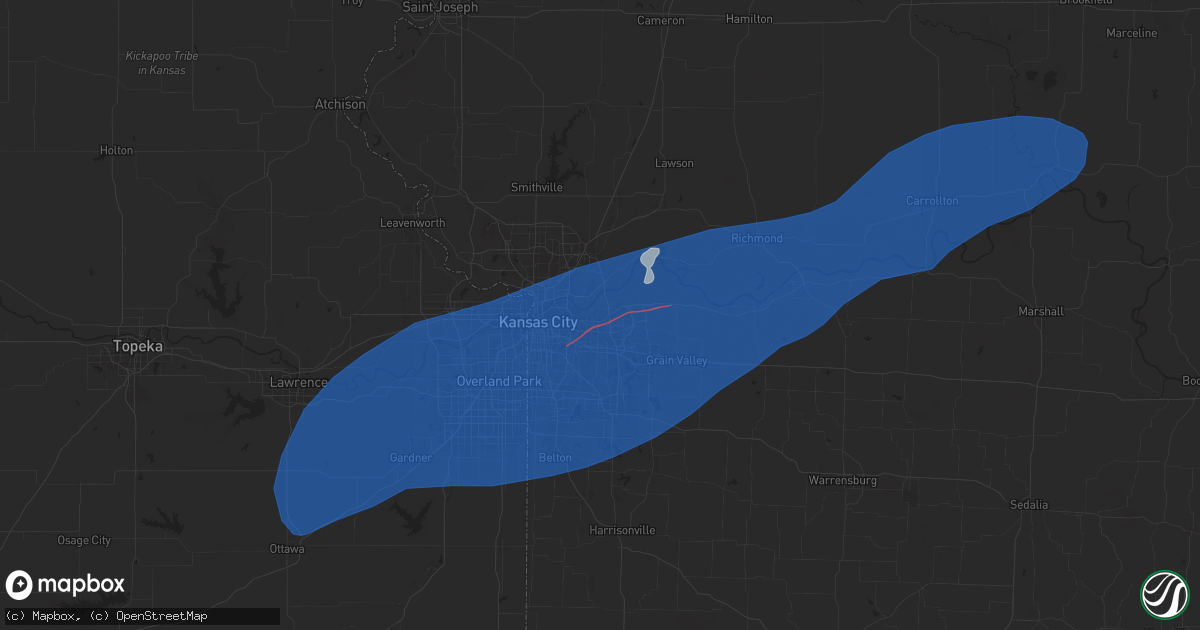
Hail Map in Independence, MO on June 3, 2025
Get this storm
June 3 map
$229
one time, instant access
Download today. No call, no setup
Keep the $229
Bought the map and want the full workflow? Apply the entire $229 to a subscription within 7 days. None of it is wasted.
Every map, not just this one
This buys you this map. Subscription and you get every map we run, in the markets you choose from a few cities to whole states to nationwide. Plus real-time alerts the moment a storm fires.
Contact data
Name, contact info, occupancy, even credit band for addresses in the footprint. You go from where it hit to who to call.
Become the source they trust
Unlimited branding weather history reports on demand. You already have the documented answer ready for the property owner, and you are the one who showed up with it.
Property data and RoofTrace estimates
Pull up any address you have got, its value and the exact code rules for that jurisdiction, straight from One Click Code. Then RoofTrace estimates the squares, pitch, and roof value, priced the way you price.
Storm reports in Independence, MO
Independence, MO
| Date | Description |
|---|---|
| 06/03/20252:47 PM CDT | Social media report of downed power lines and bent over power poles near indian trails elementary. Time estimated from radar. |
| 06/03/20252:45 PM CDT | Relayed report of severe large tree limbs down across highway 7. Time estimated from radar. |
| 06/03/20252:40 PM CDT | Several downed trees near truman road east of route 291. Time estimated from radar. |
| 06/03/20252:40 PM CDT | Social media photos and reports of trees down on jones road. Time estimated from radar. |
| 06/03/20252:40 PM CDT | Social media report and photo of downed tree damaging a vehicle near alexander road. Time estimated from radar. |
| 06/03/20252:40 PM CDT | Downed tree onto a boat at a residence near jackson drive. Time estimated from radar. |
| 06/03/20252:37 PM CDT | Storm survey team has noted damage consistent with a tornado. More information to come. |
| 06/03/20252:35 PM CDT | Em relayed images of multiple trees snapped... Downed over roadway... Or on homes. Time estimated from radar. |
| 06/03/20252:30 PM CDT | Em relayed images of large tree snapped/down just ne of intersection of 35th and crysler. Time estimated from radar. |
| 06/03/20252:30 PM CDT | Multiple reports of downed trees between independence and raytown. Time estimated from radar. |
| 06/03/20252:30 PM CDT | Several downed or snapped trees near lees summit road. Time estimated from radar. |
All States Impacted by Hail Map on June 3, 2025
All Cities Impacted by Hail Map on June 3, 2025
- Long Island, KS
- Stamford, NE
- Orleans, NE
- Alma, NE
- Holdrege, NE
- Oxford, NE
- Atlanta, NE
- Bertrand, NE
- Loomis, NE
- Funk, NE
- Wilcox, NE
- Minden, NE
- Hildreth, NE
- Axtell, NE
- Heartwell, NE
- Holstein, NE
- Kenesaw, NE
- Juniata, NE
- Roseland, NE
- Medford, OK
- Caldwell, KS
- Anthony, KS
- El Dorado, KS
- Conway Springs, KS
- Augusta, KS
- Potwin, KS
- Towanda, KS
- Benton, KS
- Rose Hill, KS
- Douglass, KS
- Clearwater, KS
- Viola, KS
- Wichita, KS
- Goddard, KS
- Argonia, KS
- Milan, KS
- Andover, KS
- Milton, KS
- Leon, KS
- Mulvane, KS
- Belle Plaine, KS
- Bluff City, KS
- Derby, KS
- Eureka, KS
- Haysville, KS
- Mcconnell Afb, KS
- Rosalia, KS
- Freeport, KS
- Harper, KS
- Danville, KS
- Peck, KS
- Medicine Lodge, KS
- Isabel, KS
- Sayre, OK
- Cheyenne, OK
- Elk City, OK
- Kiowa, KS
- Rockford, IL
- Winnebago, IL
- Belvidere, IL
- Caledonia, IL
- Poplar Grove, IL
- Capron, IL
- Loves Park, IL
- Harvard, IL
- Machesney Park, IL
- Hebron, IL
- Genoa City, WI
- Roscoe, IL
- Burlington, WI
- Lake Geneva, WI
- Walworth, WI
- Sharon, WI
- Fontana, WI
- East Troy, WI
- Union Grove, WI
- Darien, WI
- South Beloit, IL
- Avalon, WI
- Waterford, WI
- Waukesha, WI
- Mukwonago, WI
- Williams Bay, WI
- Franksville, WI
- Elkhorn, WI
- Rochester, WI
- Rockton, IL
- Eagle, WI
- Big Bend, WI
- Clinton, WI
- Muskego, WI
- Springfield, WI
- Delavan, WI
- Beloit, WI
- Whitewater, WI
- Janesville, WI
- Kansasville, WI
- Pecatonica, IL
- Carter, OK
- Bison, OK
- Garden Prairie, IL
- Salem, WI
- Hales Corners, WI
- Caledonia, WI
- Milwaukee, WI
- Franklin, WI
- New Berlin, WI
- Dill City, OK
- Canute, OK
- Waukomis, OK
- Mayfield, KS
- Le Roy, KS
- Udall, KS
- Rock, KS
- Hennessey, OK
- Foss, OK
- Sentinel, OK
- South Milwaukee, WI
- Oak Creek, WI
- Greendale, WI
- Sturtevant, WI
- Saint Francis, WI
- Cudahy, WI
- Racine, WI
- Watonga, OK
- Wellington, KS
- Duke, OK
- Mangum, OK
- Gould, OK
- Kansas City, MO
- Independence, MO
- Cordell, OK
- Claude, TX
- Bessie, OK
- Clinton, OK
- Corn, OK
- Oswego, IL
- Plainfield, IL
- Lone Wolf, OK
- Naperville, IL
- Lawrence, KS
- Baldwin City, KS
- Ottawa, KS
- Edgerton, KS
- Wellsville, KS
- Eudora, KS
- Stilwell, KS
- Gardner, KS
- Bucyrus, KS
- Olathe, KS
- Overland Park, KS
- New Century, KS
- Spring Hill, KS
- De Soto, KS
- Lenexa, KS
- Leawood, KS
- Grandview, MO
- Romeoville, IL
- Bolingbrook, IL
- Bonner Springs, KS
- Shawnee, KS
- Linwood, KS
- Mission, KS
- Prairie Village, KS
- Kansas City, KS
- Joliet, IL
- Crest Hill, IL
- Lockport, IL
- Basehor, KS
- Tonganoxie, KS
- Riverside, MO
- Liberty, MO
- Buckner, MO
- Belton, MO
- Lees Summit, MO
- Greenwood, MO
- Pleasant Hill, MO
- Raymore, MO
- Douglas, OK
- Lake Powell, UT
- Hanksville, UT
- Olustee, OK
- Eldorado, OK
- Altus, OK
- Lone Jack, MO
- Grain Valley, MO
- Bates City, MO
- Blue Springs, MO
- Oak Grove, MO
- Odessa, MO
- Sibley, MO
- Lexington, MO
- Napoleon, MO
- Mayview, MO
- Levasy, MO
- Wellington, MO
- Orrick, MO
- Higginsville, MO
- Excelsior Springs, MO
- Missouri City, MO
- Camden, MO
- Henrietta, MO
- Hardin, MO
- Richmond, MO
- Pleasant View, CO
- Wakita, OK
- Jet, OK
- Lucien, OK
- Marshall, OK
- Covington, OK
- Ames, OK
- Amorita, OK
- Burlington, OK
- Elmer, OK
- Norborne, MO
- Sweet Springs, MO
- Blackburn, MO
- Edmond, OK
- Perry, OK
- Concordia, MO
- Rayville, MO
- Manchester, OK
- Nash, OK
- Oxford, KS
- Winfield, KS
- Billings, OK
- Flagstaff, AZ
- Newcastle, OK
- Blanchard, OK
- Guthrie, OK
- Norman, OK
- Oklahoma City, OK
- Altus Afb, OK
- Headrick, OK
- Tipton, OK
- Goltry, OK
- Quincy, MO
- Lamont, OK
- Hunter, OK
- Osceola, MO
- Garber, OK
- Fort Cobb, OK
- Warsaw, MO
- Frederick, OK
- Malta Bend, MO
- Coyle, OK
- Mulhall, OK
- Marshall, MO
- Roosevelt, OK
- Mountain Park, OK
- Meno, OK
- Nipton, CA
- Binger, OK
- Chillicothe, TX
- Odell, TX
- Vernon, TX
- Davidson, OK
- Hollister, OK
- Oklaunion, TX
- Loveland, OK
- Tuttle, OK
- Mustang, OK
- Orlando, OK
- Carrollton, MO
- Green Ridge, MO
- Sedalia, MO
- Ionia, MO
- Drummond, OK
- Mountain View, OK
- Cortez, CO
- Yellow Jacket, CO
- Sloan, NV
- Red Rock, OK
- Colorado City, AZ
- Hermitage, MO
- Lawton, OK
- Morrison, OK
- Dove Creek, CO
- Stillwater, OK
- Seligman, AZ
- Mora, MO
- Cole Camp, MO
- Stamford, TX
- Henderson, NV
- Haskell, TX
- Electra, TX
- Waverly, MO
- Dover, MO
- Corder, MO
- Bosworth, MO
- De Witt, MO
- Triplett, MO
- Bogard, MO
- Urbana, MO
- Elgin, OK
- Lincoln, MO
- Joshua Tree, CA
- Yukon, OK
- Pawnee, OK
- Throckmorton, TX
- Marland, OK
- Iowa Park, TX
- Stover, MO
- Ralston, OK
- Hurricane, UT
- Trenton, MO
- Jamesport, MO
- Chillicothe, MO
- Chula, MO
- Laredo, MO
- Humphreys, MO
- Browning, MO
- Galt, MO
- Milan, MO
- Green City, MO
- Green Castle, MO
- Novinger, MO
- Greentop, MO
- Queen City, MO
- Kirksville, MO
- Worthington, MO
- Brashear, MO
- Downing, MO
- Memphis, MO
- Baring, MO
- Rutledge, MO
- Brunswick, MO
- Miami, MO
- Hale, MO
- Tina, MO
- Smithton, MO
- Otterville, MO
- Hughesville, MO
- Pilot Grove, MO
- Bunceton, MO
- Tuba City, AZ
- Atlanta, MO
- Amber, OK
- Clifton Hill, MO
- Preston, MO
- Medicine Park, OK
- Higbee, MO
- Sedan, KS
- Fairmont, OK
- Fort Sill, OK
- Twentynine Palms, CA
- Wheatland, OK
- Boonville, MO
- Nelson, MO
- Franklin, MO
- Blackwater, MO
- New Franklin, MO
- Rocheport, MO
- Wooldridge, MO
- Columbia, MO
- Prairie Home, MO
- Harrisburg, MO
- Fayette, MO
- Clark, MO
- Washington, OK
- Choctaw, OK
- Elmore City, OK
- Pauls Valley, OK
- Grandfield, OK
- Devol, OK
- Chattanooga, OK
- Walters, OK
- Faxon, OK
- Geronimo, OK
- Cache, OK
- Randlett, OK
- Macon, MO
- Macks Creek, MO
- Maysville, OK
- Novelty, MO
- Foster, OK
- Wichita Falls, TX
- Leonard, MO
- Peru, KS
- Temple, OK
- Las Vegas, NV
- La Plata, MO
- Pawhuska, OK
- Hurdland, MO
- Shidler, OK
- Holliday, TX
- Gorin, MO
- Arbela, MO
- Wyaconda, MO
- Williamstown, MO
- Kahoka, MO
- Luray, MO
- Saint Patrick, MO
- Sheppard Afb, TX
- Canton, MO
- Alexandria, MO
- Bonaparte, IA
- Mount Sterling, IA
- Wayland, MO
- Farmington, IA
- Revere, MO
- Cantril, IA
- Woodson, TX
- Albany, TX
- Argyle, IA
- Donnellson, IA
- Ringling, OK
- La Belle, MO
- Wayne, OK
- Ewing, MO
- Tunas, MO
- Buffalo, MO
- Windyville, MO
- Anabel, MO
- Sturgeon, MO
- Edina, MO
- Clarence, MO
- Hallsville, MO
- Centralia, MO
- North Las Vegas, NV
- Paris, MO
- Knox City, MO
- Newark, MO
- Shelbyville, MO
- Bethel, MO
- Shelbina, MO
- Thompson, MO
- Loco, OK
- Lexington, OK
- Noble, OK
- Lewistown, MO
- Monticello, MO
- Wynnewood, OK
- Hillsboro, IA
- Salem, IA
- Montrose, IA
- Keokuk, IA
- West Point, IA
- Warsaw, IL
- Hamilton, IL
- Henrietta, TX
- Scotland, TX
- Breckenridge, TX
- Fort Madison, IA
- New London, IA
- Mount Pleasant, IA
- Saint Paul, IA
- Macomb, OK
- Lockridge, IA
- Stockport, IA
- Birmingham, IA
- Fairfield, IA
- Tecumseh, OK
- Douds, IA
- Keosauqua, IA
- Archer City, TX
- Windthorst, TX
- Healdton, OK
- Comanche, OK
- Duncan, OK
- Raton, NM
- Wilson, OK
- Springer, OK
- Davis, OK
- Purcell, OK
- Nauvoo, IL
- Mount Union, IA
- Danville, IA
- Yarmouth, IA
- Wever, IA
- Winfield, IA
- Middletown, IA
- Sperry, IA
- Denmark, IA
- Carthage, IL
- Niota, IL
- Burlington, IA
- Dallas City, IL
- West Burlington, IA
- Lomax, IL
- Basco, IL
- Elvaston, IL
- West Point, IL
- La Harpe, IL
- Mendon, IL
- Sutter, IL
- Loraine, IL
- Ratliff City, OK
- Ardmore, OK
- Graham, OK
- Supai, AZ
- Williams, AZ
- Sulphur, OK
- Farmington, NM
- Mill Creek, OK
- Tishomingo, OK
- Bellevue, TX
- Kingman, AZ
- Roff, OK
- Caddo, TX
- Milburn, OK
- Wapanucka, OK
- Coleman, OK
- Carman, IL
- Muscatine, IA
- New Boston, IL
- Oakville, IA
- Morning Sun, IA
- Illinois City, IL
- Gladstone, IL
- Wapello, IA
- Mediapolis, IA
- Stronghurst, IL
- Keithsburg, IL
- Aledo, IL
- Biggsville, IL
- Oquawka, IL
- Seaton, IL
- Taylor Ridge, IL
- Joy, IL
- Reynolds, IL
- Letts, IA
- Columbus Junction, IA
- Monmouth, IL
- Galesburg, IL
- Media, IL
- Raritan, IL
- Alexis, IL
- Cameron, IL
- Roseville, IL
- Little York, IL
- Gerlaw, IL
- Smithshire, IL
- Sciota, IL
- Kirkwood, IL
- Berwick, IL
- Blandinsville, IL
- Galva, IL
- New Windsor, IL
- Matherville, IL
- Ophiem, IL
- Knoxville, IL
- Alpha, IL
- Lynn Center, IL
- Milan, IL
- Sherrard, IL
- East Galesburg, IL
- Cambridge, IL
- Wataga, IL
- Altona, IL
- Oneida, IL
- Viola, IL
- Woodhull, IL
- Henderson, IL
- North Henderson, IL
- Rio, IL
- Victoria, IL
- Rapids City, IL
- Moline, IL
- Blue Grass, IA
- Andover, IL
- Buffalo, IA
- Osco, IL
- Cordova, IL
- Carbon Cliff, IL
- Princeton, IA
- Eldridge, IA
- Bishop Hill, IL
- Colona, IL
- Hampton, IL
- Hillsdale, IL
- Davenport, IA
- Andalusia, IL
- Bettendorf, IA
- Le Claire, IA
- Port Byron, IL
- Rock Island, IL
- Geneseo, IL
- Montpelier, IA
- East Moline, IL
- Pleasant Valley, IA
- Coal Valley, IL
- Orion, IL
- Silvis, IL
- North Rim, AZ
- Ranger, TX
- Cisco, TX
- Tupelo, OK
- Logandale, NV
- Needles, CA
- Moran, TX
- Bowie, TX
- Edwards, MO
- Boley, OK
- Castle, OK
- Paden, OK
- Okemah, OK
- Bristow, OK
- Ada, OK
- Fitzhugh, OK
- Atkinson, IL
- Annawan, IL
- Neponset, IL
- Kewanee, IL
- Albany, IL
- Sheffield, IL
- Erie, IL
- Camanche, IA
- Prophetstown, IL
- Long Grove, IA
- Stonewall, OK
- Allen, OK
- Sunset, TX
- Jacksboro, TX
- Olney, TX
- Loving, TX
- Strawn, TX
- Caliente, NV
- Mineral, IL
- Clinton, IA
- Fenton, IL
- Hooppole, IL
- Fulton, IL
- Tampico, IL
- Wyanet, IL
- Lyndon, IL
- Morrison, IL
- Montague, TX
- Chico, TX
- Bryson, TX
- Baileyville, IL
- Shannon, IL
- Freeport, IL
- Forreston, IL
- Forestburg, TX
- Saint Jo, TX
- Bridgeport, TX
- Alvord, TX
- Atoka, OK
- Coalgate, OK
- Muenster, TX
- Mohave Valley, AZ
- Dryden, TX
- Princeton, IL
- New Bedford, IL
- Deer Grove, IL
- Manlius, IL
- Walnut, IL
- Harmon, IL
- Milledgeville, IL
- Rock Falls, IL
- Chadwick, IL
- Sterling, IL
- Ohio, IL
- Amboy, IL
- Polo, IL
- Dixon, IL
- Woosung, IL
- Oregon, IL
- La Moille, IL
- Malden, IL
- Dover, IL
- Decatur, TX
- Eldena, IL
- Sublette, IL
- Van Orin, IL
- Fort Mohave, AZ
- Gordon, TX
- Gainesville, TX
- Lindsay, TX
- Era, TX
- Rosston, TX
- Stringtown, OK
- Versailles, MO
- Yucca, AZ
- Millsap, TX
- Mineral Wells, TX
- Santo, TX
- Madill, OK
- Valley View, TX
- Sanger, TX
- Collinsville, TX
- Whitesboro, TX
- Lipan, TX
- Weatherford, TX
- Cottonwood, AZ
- Mingus, TX
- Stephenville, TX
- Essex, CA
- Krum, TX
- Pilot Point, TX
- Howe, TX
- Tioga, TX
- Sherman, TX
- Gunter, TX
- Oglesby, TX
- Ponder, TX
- Amboy, CA
- Tolar, TX
- Sedona, AZ
- Bluff Dale, TX
- West Brooklyn, IL
- Ashton, IL
- Franklin Grove, IL
- Davis Junction, IL
- Stillman Valley, IL
- Rochelle, IL
- Byron, IL
- Chana, IL
- Mount Morris, IL
- Monroe Center, IL
- Holcomb, IL
- Lindenwood, IL
- Steward, IL
- Mendota, IL
- Compton, IL
- Malta, IL
- Shabbona, IL
- Paw Paw, IL
- Lee, IL
- Earlville, IL
- Waterman, IL
- Dekalb, IL
- Granbury, TX
- Gatesville, TX
- Denton, TX
- Justin, TX
- Crawford, TX
- Cresson, TX
- Godley, TX
- Fort Worth, TX
- Aledo, TX
- Denison, TX
- Eastland, TX
- Fort Hood, TX
- Tom Bean, TX
- Bells, TX
- Whitewright, TX
- Van Alstyne, TX
- Bonham, TX
- Savoy, TX
- Ector, TX
- Ravenna, TX
- Gorman, TX
- McGregor, TX
- Desdemona, TX
- Climax Springs, MO
- Gravois Mills, MO
- Sunrise Beach, MO
- Camdenton, MO
- Florence, MO
- Barnett, MO
- Eldon, MO
- Fortuna, MO
- Tuscumbia, MO
- Lake Ozark, MO
- Rocky Mount, MO
- Syracuse, MO
- Latham, MO
- Olean, MO
- Russellville, MO
- California, MO
- Tipton, MO
- Clarksburg, MO
- Aquilla, TX
- De Leon, TX
- Dublin, TX
- Valley Mills, TX
- Rising Star, TX
- Comanche, TX
- May, TX
- Hico, TX
- Abbott, TX
- Sidney, TX
- Woodway, TX
- Moody, TX
- Garland, TX
- Blanket, TX
- Early, TX
- Zephyr, TX
- Gustine, TX
- Carlton, TX
- Temple, TX
- Meridian, TX
- Walnut Springs, TX
- Morgan, TX
- Kopperl, TX
- Mullin, TX
- Goldthwaite, TX
- Hamilton, TX
- Clifton, TX
- Richland Springs, TX
- Parker Dam, CA
- San Saba, TX
- Parker, AZ
- Jonesboro, TX
- Lometa, TX
- Evant, TX
- Brady, TX
- Rochelle, TX
- Purmela, TX
- Voca, TX
- Fredonia, TX
- Mason, TX
- Quartzsite, AZ
- Crawfordville, FL


