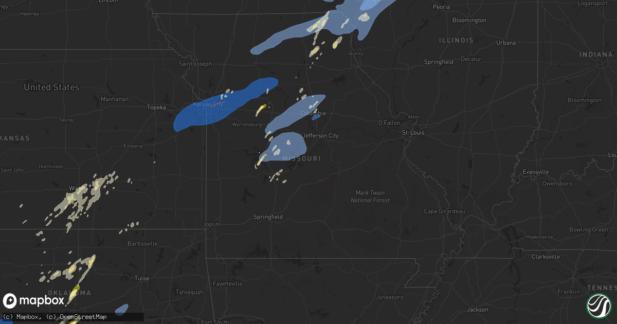
Hail Map in Missouri on June 3, 2025
Get this storm
June 3 map
$229
one time, instant access
Download today. No call, no setup
Keep the $229
Bought the map and want the full workflow? Apply the entire $229 to a subscription within 7 days. None of it is wasted.
Every map, not just this one
This buys you this map. Subscription and you get every map we run, in the markets you choose from a few cities to whole states to nationwide. Plus real-time alerts the moment a storm fires.
Contact data
Name, contact info, occupancy, even credit band for addresses in the footprint. You go from where it hit to who to call.
Become the source they trust
Unlimited branding weather history reports on demand. You already have the documented answer ready for the property owner, and you are the one who showed up with it.
Property data and RoofTrace estimates
Pull up any address you have got, its value and the exact code rules for that jurisdiction, straight from One Click Code. Then RoofTrace estimates the squares, pitch, and roof value, priced the way you price.
Storm reports in Missouri
Missouri
| Date | Description |
|---|---|
| 06/03/20255:59 PM CDT | Marion county dispatch reported a large tree blown onto power lines at the intersection of hamilton and dickerson streets... Knocking out power to about 100 residences. |
| 06/03/20255:59 PM CDT | Marion county dispatch reported a large tree blown onto power lines at the intersection of hamilton and dickerson streets... Knocking o |
| 06/03/20255:41 PM CDT | Corrects previous tstm wnd dmg report from 1 ne columbia. Wind gusts estimated at 50-55 mph. |
| 06/03/20255:06 PM CDT | Trees down blocking highway bb near rocheport. Time estimated from radar. |
| 06/03/20255:04 PM CDT | Knox county dispatch reported a tree down in the town of baring... Mo. Time estimated from radar. |
| 06/03/20255:01 PM CDT | Knox county dispatch reported power lines down in edina. Time estimated from radar. Dispatch received report at 5:15 pm. |
| 06/03/20255:00 PM CDT | Trees down. |
| 06/03/20254:56 PM CDT | Downed wires near reed street. Time estimated from radar. |
| 06/03/20254:56 PM CDT | Downed wires near county road 433. Time estimated from radar. |
| 06/03/20254:56 PM CDT | Downed tree and wires near halleck street. Time estimated from radar. |
| 06/03/20254:56 PM CDT | Downed tree and wires near county road 448. Time estimated from radar. |
| 06/03/20254:54 PM CDT | Downed tree and wires near chancellor street. Time estimated from radar. |
| 06/03/20254:52 PM CDT | Several downed trees and wires near county road 419. Time estimated from radar. |
| 06/03/20254:50 PM CDT | Downed tree limbs and wires near route 240. Time estimated from radar. |
| 06/03/20254:49 PM CDT | Reports of downed tree limbs in the macon area. Time estimated from radar. |
| 06/03/20254:48 PM CDT | Multiple broken power poles south of fayette. Time estimated from radar. |
| 06/03/20254:48 PM CDT | Social media video of a downed tree at a residence. Time estimated from radar. |
| 06/03/20254:48 PM CDT | Downed tree and wires near sycamore street. Time estimated from radar. |
| 06/03/20254:47 PM CDT | Mping report of downed tree limbs near holiday acres lake. Time estimated from radar. |
| 06/03/20254:45 PM CDT | Downed tree and wires near sportsman road. Time estimated from radar. |
| 06/03/20254:45 PM CDT | Downed tree and wires near logan street. Time based on dispatch report and confirmed from radar. |
| 06/03/20254:45 PM CDT | Downed wires and power outages near billingsville road. Time estimated from radar. |
| 06/03/20254:42 PM CDT | Tree limbs downed in la plata along us highway 63. |
| 06/03/20254:39 PM CDT | Downed wires near county road 345. Time estimated from radar. |
| 06/03/20254:35 PM CDT | Downed wires near route 3. Time estimated from radar. |
| 06/03/20254:32 PM CDT | Downed wires and power outages in the |
| 06/03/20254:32 PM CDT | Downed wires and power outages in the glasgow area. Time estimated from radar. |
| 06/03/20254:32 PM CDT | Downed trees along route 3 north of clifton hill. Time estimated from radar. |
| 06/03/20254:31 PM CDT | Downed tree limbs and wires in the blackwater area. Time estimated from radar. |
| 06/03/20254:31 PM CDT | Downed wires reported in greentop. Time estimated from radar. |
| 06/03/20254:29 PM CDT | Delayed report... Time estimated by radar. Uprooted tree and damage to small tree limbs at outlet park at pomme de terre. |
| 06/03/20254:29 PM CDT | Delayed report... Time estimated from radar. Damage to large tree limbs at the damsite campground at pomme de terre. |
| 06/03/20254:28 PM CDT | Emergency manager reports large trees down in pilot grove. |
| 06/03/20254:25 PM CDT | Social media photo of downed trees in nelson. Time estimated from radar. |
| 06/03/20254:24 PM CDT | Downed tree limbs and wires near route 5. Time estimated from radar. |
| 06/03/20254:23 PM CDT | Reports of downed trees in slater. Time confirmed from radar. |
| 06/03/20254:20 PM CDT | A local report indicates 62 MPH wind near Sedalia Memorial Arpt |
| 06/03/20254:18 PM CDT | Several downed trees in the southgate area. Photos via social media. Time estimated from radar. |
| 06/03/20254:17 PM CDT | Several reports of downed tree limbs and power lines in sedalia and surrounding areas. Time estimated from radar. |
| 06/03/20254:17 PM CDT | Downed tree limbs and wires near route h. Time estimated from radar. |
| 06/03/20254:12 PM CDT | Downed tree and wires near prather avenue. Time estimated from radar. |
| 06/03/20254:10 PM CDT | Downed wires near lincoln street. Time estimated from radar. |
| 06/03/20254:10 PM CDT | Several reports of large trees down in sedalia... Including one onto a vehicle on u.s. Highway 50. Time estimated from radar. |
| 06/03/20254:08 PM CDT | Mping report of downed and uprooted trees on the east side of slater. Time estimated from radar. |
| 06/03/20254:06 PM CDT | Downed wires and power outages near county road 111. Time estimated from radar. |
| 06/03/20254:06 PM CDT | Social media photos of downed trees in slater. Time estimated from radar. |
| 06/03/20254:03 PM CDT | Downed wires and power outages near cazzell. Time estimated from radar. |
| 06/03/20253:58 PM CDT | A local report indicates 1.00 inch wind near Warsaw |
| 06/03/20253:57 PM CDT | Tree damage and power lines down. |
| 06/03/20253:53 PM CDT | Social media reports and photos of trees down in marshall. Time estimated from radar. |
| 06/03/20253:52 PM CDT | Several downed trees...some up to 4 feet in diameter...reported north to northeast of browning. Time estimated from radar. |
| 06/03/20253:50 PM CDT | Large tree uprooted and split. Cornfield debris strewn across property. Heavy fire pit lifted and moved 10 feet. Metal framing twisted and bent. Metal chairs lifted and |
| 06/03/20253:44 PM CDT | Downed tree limbs near u.s. Highway 24 east of lexington. Time estimated from radar. |
| 06/03/20253:42 PM CDT | Downed wires and power outages reported in the norborne area. Time estimated from radar. |
| 06/03/20253:28 PM CDT | Side and door of machine shed blown off... Power pole snapped... And multiple large limbs down. Time estimated from radar. |
| 06/03/20253:27 PM CDT | Mping report of downed tree limbs in the lexington area. Time confirmed from radar. |
| 06/03/20253:23 PM CDT | Downed tree and wires near merle road. Time estimated from radar. |
| 06/03/20253:20 PM CDT | Private weather sensor. |
| 06/03/20253:16 PM CDT | Social media report of downed tree limbs near utica. Time estimated from radar. |
| 06/03/20253:06 PM CDT | Downed wires and power outages near route ee. Time estimated from radar. |
| 06/03/20252:59 PM CDT | Downed wires and power outages near 203rd street. Time estimated from radar. |
| 06/03/20252:59 PM CDT | Several reports of downed trees north of lake tapawingo. Time estimated from radar. |
| 06/03/20252:55 PM CDT | Downed wires and power outages near central street. Time estimated from radar. |
| 06/03/20252:54 PM CDT | Downed tree and wires near ley street. Time estimated from radar. |
| 06/03/20252:51 PM CDT | Downed wires and power outages near military club road. Time estimated from radar. |
| 06/03/20252:47 PM CDT | Social media report of downed power lines and bent over power poles near indian trails elementary. Time estimated from radar. |
| 06/03/20252:47 PM CDT | Downed wires near scott avenue. Time estimated from radar. |
| 06/03/20252:45 PM CDT | Relayed report of severe large tree limbs down across highway 7. Time estimated from radar. |
| 06/03/20252:44 PM CDT | Downed tree limbs and wires near missouri city road. Time estimated from radar. |
| 06/03/20252:40 PM CDT | Several downed trees near truman road east of route 291. Time estimated from radar. |
| 06/03/20252:40 PM CDT | Social media photos and reports of trees down on jones road. Time estimated from radar. |
| 06/03/20252:40 PM CDT | Downed tree onto a boat at a residence near jackson drive. Time estimated from radar. |
| 06/03/20252:40 PM CDT | Downed wires near current street. Time estimated from radar. |
| 06/03/20252:40 PM CDT | Social media report and photo of downed tree damaging a vehicle near alexander road. Time estimated from radar. |
| 06/03/20252:37 PM CDT | Storm survey team has noted damage consistent with a tornado. More information to come. |
| 06/03/20252:35 PM CDT | Em relayed images of multiple trees snapped... Downed over roadway... Or on homes. Time estimated from radar. |
| 06/03/20252:34 PM CDT | Private weather sensor. |
| 06/03/20252:30 PM CDT | Em relayed images of large tree snapped/down just ne of intersection of 35th and crysler. Time estimated from radar. |
| 06/03/20252:30 PM CDT | Downed wires near askew avenue. Time estimated from radar. |
| 06/03/20252:30 PM CDT | Multiple reports of downed trees between independence and raytown. Time estimated from radar. |
| 06/03/20252:30 PM CDT | Several downed or snapped trees near lees summit road. Time estimated from radar. |
| 06/03/20252:30 PM CDT | Downed wires and power outages near crisp avenue. Time estimated from radar. |
| 06/03/20252:27 PM CDT | Multiple reports of tree limbs and wires down in the raytown area. Time estimated from radar. |
| 06/03/20252:26 PM CDT | Downed tree onto a vehicle near 47th and maywood. Time estimated from radar. |
| 06/03/20252:26 PM CDT | Semi blown over near i-435 and raytown road. Multiple trees down east of this location. Time estimated from radar. |
| 06/03/20252:25 PM CDT | Confirmed tornado via radar and video footage. |
| 06/03/20252:23 PM CDT | Downed tree and wires near quincy avenue. Time estimated from radar. |
| 06/03/20252:23 PM CDT | Downed tree limbs and wires near 66th street. Time estimated from radar. |
| 06/03/20252:23 PM CDT | Downed wires near robinhood lane. Time estimated from radar. |
| 06/03/20252:19 PM CDT | Downed tree and wires near 70th street. Time estimated from radar. |
| 06/03/20252:12 PM CDT | Downed tree limbs and wires near walnut street. Time estimated from radar. |
| 06/03/20252:09 PM CDT | Downed wires and power outages east of platte city. Time estimated from radar. |
| 06/02/20259:01 PM CDT | Time estimated by radar. Tree down blocking allen road. |
| 06/02/20258:59 PM CDT | Time estimated by radar. Tree down blocking vaughan road. |
| 06/02/20258:54 PM CDT | Time estimated by radar. Trees down on blue springs drive. |
| 06/02/20258:46 PM CDT | Delayed report via email and pics. Trees down... Damage to roofing... Roof lifted off of patio. |
| 06/02/20258:38 PM CDT | Time estimated from radar. Emergency management reported multiple trees down in the gravois mills and laurie areas. |
| 06/02/20258:35 PM CDT | A local report indicates 61 MPH wind near 4 WSW Laurie |
| 06/02/20257:50 PM CDT | Photo of uprooted tree on car 10 miles north of wheatland on benton hickory county line. |
All States Impacted by Hail Map on June 3, 2025
Cities Impacted by Hail Map on June 3, 2025
- Long Island, KS
- Stamford, NE
- Orleans, NE
- Alma, NE
- Holdrege, NE
- Oxford, NE
- Atlanta, NE
- Bertrand, NE
- Loomis, NE
- Funk, NE
- Wilcox, NE
- Minden, NE
- Hildreth, NE
- Axtell, NE
- Heartwell, NE
- Holstein, NE
- Kenesaw, NE
- Juniata, NE
- Roseland, NE
- Medford, OK
- Caldwell, KS
- Anthony, KS
- El Dorado, KS
- Conway Springs, KS
- Augusta, KS
- Potwin, KS
- Towanda, KS
- Benton, KS
- Rose Hill, KS
- Douglass, KS
- Clearwater, KS
- Viola, KS
- Wichita, KS
- Goddard, KS
- Argonia, KS
- Milan, KS
- Andover, KS
- Milton, KS
- Leon, KS
- Mulvane, KS
- Belle Plaine, KS
- Bluff City, KS
- Derby, KS
- Eureka, KS
- Haysville, KS
- Mcconnell Afb, KS
- Rosalia, KS
- Freeport, KS
- Harper, KS
- Danville, KS
- Peck, KS
- Medicine Lodge, KS
- Isabel, KS
- Sayre, OK
- Cheyenne, OK
- Elk City, OK
- Kiowa, KS
- Rockford, IL
- Winnebago, IL
- Belvidere, IL
- Caledonia, IL
- Poplar Grove, IL
- Capron, IL
- Loves Park, IL
- Harvard, IL
- Machesney Park, IL
- Hebron, IL
- Genoa City, WI
- Roscoe, IL
- Burlington, WI
- Lake Geneva, WI
- Walworth, WI
- Sharon, WI
- Fontana, WI
- East Troy, WI
- Union Grove, WI
- Darien, WI
- South Beloit, IL
- Avalon, WI
- Waterford, WI
- Waukesha, WI
- Mukwonago, WI
- Williams Bay, WI
- Franksville, WI
- Elkhorn, WI
- Rochester, WI
- Rockton, IL
- Eagle, WI
- Big Bend, WI
- Clinton, WI
- Muskego, WI
- Springfield, WI
- Delavan, WI
- Beloit, WI
- Whitewater, WI
- Janesville, WI
- Kansasville, WI
- Pecatonica, IL
- Carter, OK
- Bison, OK
- Garden Prairie, IL
- Salem, WI
- Hales Corners, WI
- Caledonia, WI
- Milwaukee, WI
- Franklin, WI
- New Berlin, WI
- Dill City, OK
- Canute, OK
- Waukomis, OK
- Mayfield, KS
- Le Roy, KS
- Udall, KS
- Rock, KS
- Hennessey, OK
- Foss, OK
- Sentinel, OK
- South Milwaukee, WI
- Oak Creek, WI
- Greendale, WI
- Sturtevant, WI
- Saint Francis, WI
- Cudahy, WI
- Racine, WI
- Watonga, OK
- Wellington, KS
- Duke, OK
- Mangum, OK
- Gould, OK
- Kansas City, MO
- Independence, MO
- Cordell, OK
- Claude, TX
- Bessie, OK
- Clinton, OK
- Corn, OK
- Oswego, IL
- Plainfield, IL
- Lone Wolf, OK
- Naperville, IL
- Lawrence, KS
- Baldwin City, KS
- Ottawa, KS
- Edgerton, KS
- Wellsville, KS
- Eudora, KS
- Stilwell, KS
- Gardner, KS
- Bucyrus, KS
- Olathe, KS
- Overland Park, KS
- New Century, KS
- Spring Hill, KS
- De Soto, KS
- Lenexa, KS
- Leawood, KS
- Grandview, MO
- Romeoville, IL
- Bolingbrook, IL
- Bonner Springs, KS
- Shawnee, KS
- Linwood, KS
- Mission, KS
- Prairie Village, KS
- Kansas City, KS
- Joliet, IL
- Crest Hill, IL
- Lockport, IL
- Basehor, KS
- Tonganoxie, KS
- Riverside, MO
- Liberty, MO
- Buckner, MO
- Belton, MO
- Lees Summit, MO
- Greenwood, MO
- Pleasant Hill, MO
- Raymore, MO
- Douglas, OK
- Lake Powell, UT
- Hanksville, UT
- Olustee, OK
- Eldorado, OK
- Altus, OK
- Lone Jack, MO
- Grain Valley, MO
- Bates City, MO
- Blue Springs, MO
- Oak Grove, MO
- Odessa, MO
- Sibley, MO
- Lexington, MO
- Napoleon, MO
- Mayview, MO
- Levasy, MO
- Wellington, MO
- Orrick, MO
- Higginsville, MO
- Excelsior Springs, MO
- Missouri City, MO
- Camden, MO
- Henrietta, MO
- Hardin, MO
- Richmond, MO
- Pleasant View, CO
- Wakita, OK
- Jet, OK
- Lucien, OK
- Marshall, OK
- Covington, OK
- Ames, OK
- Amorita, OK
- Burlington, OK
- Elmer, OK
- Norborne, MO
- Sweet Springs, MO
- Blackburn, MO
- Edmond, OK
- Perry, OK
- Concordia, MO
- Rayville, MO
- Manchester, OK
- Nash, OK
- Oxford, KS
- Winfield, KS
- Billings, OK
- Flagstaff, AZ
- Newcastle, OK
- Blanchard, OK
- Guthrie, OK
- Norman, OK
- Oklahoma City, OK
- Altus Afb, OK
- Headrick, OK
- Tipton, OK
- Goltry, OK
- Quincy, MO
- Lamont, OK
- Hunter, OK
- Osceola, MO
- Garber, OK
- Fort Cobb, OK
- Warsaw, MO
- Frederick, OK
- Malta Bend, MO
- Coyle, OK
- Mulhall, OK
- Marshall, MO
- Roosevelt, OK
- Mountain Park, OK
- Meno, OK
- Nipton, CA
- Binger, OK
- Chillicothe, TX
- Odell, TX
- Vernon, TX
- Davidson, OK
- Hollister, OK
- Oklaunion, TX
- Loveland, OK
- Tuttle, OK
- Mustang, OK
- Orlando, OK
- Carrollton, MO
- Green Ridge, MO
- Sedalia, MO
- Ionia, MO
- Drummond, OK
- Mountain View, OK
- Cortez, CO
- Yellow Jacket, CO
- Sloan, NV
- Red Rock, OK
- Colorado City, AZ
- Hermitage, MO
- Lawton, OK
- Morrison, OK
- Dove Creek, CO
- Stillwater, OK
- Seligman, AZ
- Mora, MO
- Cole Camp, MO
- Stamford, TX
- Henderson, NV
- Haskell, TX
- Electra, TX
- Waverly, MO
- Dover, MO
- Corder, MO
- Bosworth, MO
- De Witt, MO
- Triplett, MO
- Bogard, MO
- Urbana, MO
- Elgin, OK
- Lincoln, MO
- Joshua Tree, CA
- Yukon, OK
- Pawnee, OK
- Throckmorton, TX
- Marland, OK
- Iowa Park, TX
- Stover, MO
- Ralston, OK
- Hurricane, UT
- Trenton, MO
- Jamesport, MO
- Chillicothe, MO
- Chula, MO
- Laredo, MO
- Humphreys, MO
- Browning, MO
- Galt, MO
- Milan, MO
- Green City, MO
- Green Castle, MO
- Novinger, MO
- Greentop, MO
- Queen City, MO
- Kirksville, MO
- Worthington, MO
- Brashear, MO
- Downing, MO
- Memphis, MO
- Baring, MO
- Rutledge, MO
- Brunswick, MO
- Miami, MO
- Hale, MO
- Tina, MO
- Smithton, MO
- Otterville, MO
- Hughesville, MO
- Pilot Grove, MO
- Bunceton, MO
- Tuba City, AZ
- Atlanta, MO
- Amber, OK
- Clifton Hill, MO
- Preston, MO
- Medicine Park, OK
- Higbee, MO
- Sedan, KS
- Fairmont, OK
- Fort Sill, OK
- Twentynine Palms, CA
- Wheatland, OK
- Boonville, MO
- Nelson, MO
- Franklin, MO
- Blackwater, MO
- New Franklin, MO
- Rocheport, MO
- Wooldridge, MO
- Columbia, MO
- Prairie Home, MO
- Harrisburg, MO
- Fayette, MO
- Clark, MO
- Washington, OK
- Choctaw, OK
- Elmore City, OK
- Pauls Valley, OK
- Grandfield, OK
- Devol, OK
- Chattanooga, OK
- Walters, OK
- Faxon, OK
- Geronimo, OK
- Cache, OK
- Randlett, OK
- Macon, MO
- Macks Creek, MO
- Maysville, OK
- Novelty, MO
- Foster, OK
- Wichita Falls, TX
- Leonard, MO
- Peru, KS
- Temple, OK
- Las Vegas, NV
- La Plata, MO
- Pawhuska, OK
- Hurdland, MO
- Shidler, OK
- Holliday, TX
- Gorin, MO
- Arbela, MO
- Wyaconda, MO
- Williamstown, MO
- Kahoka, MO
- Luray, MO
- Saint Patrick, MO
- Sheppard Afb, TX
- Canton, MO
- Alexandria, MO
- Bonaparte, IA
- Mount Sterling, IA
- Wayland, MO
- Farmington, IA
- Revere, MO
- Cantril, IA
- Woodson, TX
- Albany, TX
- Argyle, IA
- Donnellson, IA
- Ringling, OK
- La Belle, MO
- Wayne, OK
- Ewing, MO
- Tunas, MO
- Buffalo, MO
- Windyville, MO
- Anabel, MO
- Sturgeon, MO
- Edina, MO
- Clarence, MO
- Hallsville, MO
- Centralia, MO
- North Las Vegas, NV
- Paris, MO
- Knox City, MO
- Newark, MO
- Shelbyville, MO
- Bethel, MO
- Shelbina, MO
- Thompson, MO
- Loco, OK
- Lexington, OK
- Noble, OK
- Lewistown, MO
- Monticello, MO
- Wynnewood, OK
- Hillsboro, IA
- Salem, IA
- Montrose, IA
- Keokuk, IA
- West Point, IA
- Warsaw, IL
- Hamilton, IL
- Henrietta, TX
- Scotland, TX
- Breckenridge, TX
- Fort Madison, IA
- New London, IA
- Mount Pleasant, IA
- Saint Paul, IA
- Macomb, OK
- Lockridge, IA
- Stockport, IA
- Birmingham, IA
- Fairfield, IA
- Tecumseh, OK
- Douds, IA
- Keosauqua, IA
- Archer City, TX
- Windthorst, TX
- Healdton, OK
- Comanche, OK
- Duncan, OK
- Raton, NM
- Wilson, OK
- Springer, OK
- Davis, OK
- Purcell, OK
- Nauvoo, IL
- Mount Union, IA
- Danville, IA
- Yarmouth, IA
- Wever, IA
- Winfield, IA
- Middletown, IA
- Sperry, IA
- Denmark, IA
- Carthage, IL
- Niota, IL
- Burlington, IA
- Dallas City, IL
- West Burlington, IA
- Lomax, IL
- Basco, IL
- Elvaston, IL
- West Point, IL
- La Harpe, IL
- Mendon, IL
- Sutter, IL
- Loraine, IL
- Ratliff City, OK
- Ardmore, OK
- Graham, OK
- Supai, AZ
- Williams, AZ
- Sulphur, OK
- Farmington, NM
- Mill Creek, OK
- Tishomingo, OK
- Bellevue, TX
- Kingman, AZ
- Roff, OK
- Caddo, TX
- Milburn, OK
- Wapanucka, OK
- Coleman, OK
- Carman, IL
- Muscatine, IA
- New Boston, IL
- Oakville, IA
- Morning Sun, IA
- Illinois City, IL
- Gladstone, IL
- Wapello, IA
- Mediapolis, IA
- Stronghurst, IL
- Keithsburg, IL
- Aledo, IL
- Biggsville, IL
- Oquawka, IL
- Seaton, IL
- Taylor Ridge, IL
- Joy, IL
- Reynolds, IL
- Letts, IA
- Columbus Junction, IA
- Monmouth, IL
- Galesburg, IL
- Media, IL
- Raritan, IL
- Alexis, IL
- Cameron, IL
- Roseville, IL
- Little York, IL
- Gerlaw, IL
- Smithshire, IL
- Sciota, IL
- Kirkwood, IL
- Berwick, IL
- Blandinsville, IL
- Galva, IL
- New Windsor, IL
- Matherville, IL
- Ophiem, IL
- Knoxville, IL
- Alpha, IL
- Lynn Center, IL
- Milan, IL
- Sherrard, IL
- East Galesburg, IL
- Cambridge, IL
- Wataga, IL
- Altona, IL
- Oneida, IL
- Viola, IL
- Woodhull, IL
- Henderson, IL
- North Henderson, IL
- Rio, IL
- Victoria, IL
- Rapids City, IL
- Moline, IL
- Blue Grass, IA
- Andover, IL
- Buffalo, IA
- Osco, IL
- Cordova, IL
- Carbon Cliff, IL
- Princeton, IA
- Eldridge, IA
- Bishop Hill, IL
- Colona, IL
- Hampton, IL
- Hillsdale, IL
- Davenport, IA
- Andalusia, IL
- Bettendorf, IA
- Le Claire, IA
- Port Byron, IL
- Rock Island, IL
- Geneseo, IL
- Montpelier, IA
- East Moline, IL
- Pleasant Valley, IA
- Coal Valley, IL
- Orion, IL
- Silvis, IL
- North Rim, AZ
- Ranger, TX
- Cisco, TX
- Tupelo, OK
- Logandale, NV
- Needles, CA
- Moran, TX
- Bowie, TX
- Edwards, MO
- Boley, OK
- Castle, OK
- Paden, OK
- Okemah, OK
- Bristow, OK
- Ada, OK
- Fitzhugh, OK
- Atkinson, IL
- Annawan, IL
- Neponset, IL
- Kewanee, IL
- Albany, IL
- Sheffield, IL
- Erie, IL
- Camanche, IA
- Prophetstown, IL
- Long Grove, IA
- Stonewall, OK
- Allen, OK
- Sunset, TX
- Jacksboro, TX
- Olney, TX
- Loving, TX
- Strawn, TX
- Caliente, NV
- Mineral, IL
- Clinton, IA
- Fenton, IL
- Hooppole, IL
- Fulton, IL
- Tampico, IL
- Wyanet, IL
- Lyndon, IL
- Morrison, IL
- Montague, TX
- Chico, TX
- Bryson, TX
- Baileyville, IL
- Shannon, IL
- Freeport, IL
- Forreston, IL
- Forestburg, TX
- Saint Jo, TX
- Bridgeport, TX
- Alvord, TX
- Atoka, OK
- Coalgate, OK
- Muenster, TX
- Mohave Valley, AZ
- Dryden, TX
- Princeton, IL
- New Bedford, IL
- Deer Grove, IL
- Manlius, IL
- Walnut, IL
- Harmon, IL
- Milledgeville, IL
- Rock Falls, IL
- Chadwick, IL
- Sterling, IL
- Ohio, IL
- Amboy, IL
- Polo, IL
- Dixon, IL
- Woosung, IL
- Oregon, IL
- La Moille, IL
- Malden, IL
- Dover, IL
- Decatur, TX
- Eldena, IL
- Sublette, IL
- Van Orin, IL
- Fort Mohave, AZ
- Gordon, TX
- Gainesville, TX
- Lindsay, TX
- Era, TX
- Rosston, TX
- Stringtown, OK
- Versailles, MO
- Yucca, AZ
- Millsap, TX
- Mineral Wells, TX
- Santo, TX
- Madill, OK
- Valley View, TX
- Sanger, TX
- Collinsville, TX
- Whitesboro, TX
- Lipan, TX
- Weatherford, TX
- Cottonwood, AZ
- Mingus, TX
- Stephenville, TX
- Essex, CA
- Krum, TX
- Pilot Point, TX
- Howe, TX
- Tioga, TX
- Sherman, TX
- Gunter, TX
- Oglesby, TX
- Ponder, TX
- Amboy, CA
- Tolar, TX
- Sedona, AZ
- Bluff Dale, TX
- West Brooklyn, IL
- Ashton, IL
- Franklin Grove, IL
- Davis Junction, IL
- Stillman Valley, IL
- Rochelle, IL
- Byron, IL
- Chana, IL
- Mount Morris, IL
- Monroe Center, IL
- Holcomb, IL
- Lindenwood, IL
- Steward, IL
- Mendota, IL
- Compton, IL
- Malta, IL
- Shabbona, IL
- Paw Paw, IL
- Lee, IL
- Earlville, IL
- Waterman, IL
- Dekalb, IL
- Granbury, TX
- Gatesville, TX
- Denton, TX
- Justin, TX
- Crawford, TX
- Cresson, TX
- Godley, TX
- Fort Worth, TX
- Aledo, TX
- Denison, TX
- Eastland, TX
- Fort Hood, TX
- Tom Bean, TX
- Bells, TX
- Whitewright, TX
- Van Alstyne, TX
- Bonham, TX
- Savoy, TX
- Ector, TX
- Ravenna, TX
- Gorman, TX
- McGregor, TX
- Desdemona, TX
- Climax Springs, MO
- Gravois Mills, MO
- Sunrise Beach, MO
- Camdenton, MO
- Florence, MO
- Barnett, MO
- Eldon, MO
- Fortuna, MO
- Tuscumbia, MO
- Lake Ozark, MO
- Rocky Mount, MO
- Syracuse, MO
- Latham, MO
- Olean, MO
- Russellville, MO
- California, MO
- Tipton, MO
- Clarksburg, MO
- Aquilla, TX
- De Leon, TX
- Dublin, TX
- Valley Mills, TX
- Rising Star, TX
- Comanche, TX
- May, TX
- Hico, TX
- Abbott, TX
- Sidney, TX
- Woodway, TX
- Moody, TX
- Garland, TX
- Blanket, TX
- Early, TX
- Zephyr, TX
- Gustine, TX
- Carlton, TX
- Temple, TX
- Meridian, TX
- Walnut Springs, TX
- Morgan, TX
- Kopperl, TX
- Mullin, TX
- Goldthwaite, TX
- Hamilton, TX
- Clifton, TX
- Richland Springs, TX
- Parker Dam, CA
- San Saba, TX
- Parker, AZ
- Jonesboro, TX
- Lometa, TX
- Evant, TX
- Brady, TX
- Rochelle, TX
- Purmela, TX
- Voca, TX
- Fredonia, TX
- Mason, TX
- Quartzsite, AZ
- Crawfordville, FL


