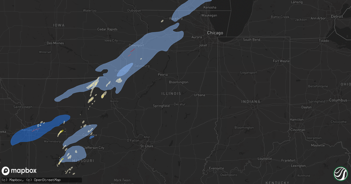
Hail Map in Illinois on June 3, 2025
Get this storm
June 3 map
$229
one time, instant access
Download today. No call, no setup
Keep the $229
Bought the map and want the full workflow? Apply the entire $229 to a subscription within 7 days. None of it is wasted.
Every map, not just this one
This buys you this map. Subscription and you get every map we run, in the markets you choose from a few cities to whole states to nationwide. Plus real-time alerts the moment a storm fires.
Contact data
Name, contact info, occupancy, even credit band for addresses in the footprint. You go from where it hit to who to call.
Become the source they trust
Unlimited branding weather history reports on demand. You already have the documented answer ready for the property owner, and you are the one who showed up with it.
Property data and RoofTrace estimates
Pull up any address you have got, its value and the exact code rules for that jurisdiction, straight from One Click Code. Then RoofTrace estimates the squares, pitch, and roof value, priced the way you price.
Storm reports in Illinois
Illinois
| Date | Description |
|---|---|
| 06/03/20256:55 PM CDT | Wind gust of 60 mph recorded on home weather station. |
| 06/03/20256:48 PM CDT | 50 to 60 mph wind gusts with torrential rain. Relayed from ham radio. |
| 06/03/20256:48 PM CDT | 50 to 60 mph wind gusts with torrential rain. Relayed from ha |
| 06/03/20256:40 PM CDT | A local report indicates 72 MPH wind near 2 SW Lone Tree |
| 06/03/20256:35 PM CDT | Large tree branches down throughout town... Some whole trees down. Time estimated from radar data. |
| 06/03/20251:55 PM CDT | Chapel road blocked by 30-36 inch diameter tree broken. Time estimated by radar. |
| 06/03/20251:38 PM CDT | Broadcast media relayed a 6 to 8 inch diameter tree branch was downed on power lines near the intersection of jackson and douglas streets in woodstock. Time estimated b |
| 06/03/20251:30 PM CDT | Downed power lines and tree branches in harvard. Time estimated by radar. |
| 06/03/20251:30 PM CDT | Ildot station southwest of marengo reported 61 mph gust. |
| 06/03/20251:30 PM CDT | Power lines damaged along harmony road south of marengo. Relayed via broadcast media... Time estimated by radar. |
| 06/03/20251:30 PM CDT | Tree branch fell on house at 600 block of grant street in harvard. Power lines downed at 600 block of dewey street. Relayed via broadcast media... Time estimated by rad |
| 06/03/20251:29 PM CDT | Trained spotter reported 65 mph gust south of harvard. Relayed via social media. |
| 06/03/20251:27 PM CDT | Photos shared by social media show that the walls of a a 45 foot by 45 foot 1-story cinder block structure collapsed. Time estimated by radar. |
| 06/03/20251:02 PM CDT | Large tree branch downed along guilford road near midway village museum in rockford. Time estimated by radar. |
| 06/03/20251:00 PM CDT | Photo shared to social media shows tree branch downed into street in southeast side of rockford. Time estimated by radar. |
| 06/03/202512:57 PM CDT | Report of multiple downed wires around rockford. Relayed via broadcast media... Time estimated by radar. |
| 06/03/202511:51 AM CDT | Pws measured gust of 59.4 mph. |
| 06/02/20258:58 PM CDT | Report of large tree downed on il-72... As well as another tree down on power lines... All in davis junction. Time estimated by radar. |
| 06/02/20258:49 PM CDT | Private weather station kilroche34 reported 58 mph gust northwest of hillcrest. |
| 06/02/20258:38 PM CDT | Corrects previous tstm wnd dmg report from 1 sse oregon. A large tree was downed blocking daysville road south of us 64 just outside of oregon. The tree has since been |
| 06/02/20258:15 PM CDT | Time estimate by radar. Power lines have been downed by the thunderstorm winds. |
| 06/02/20257:28 PM CDT | 12 power poles snapped off. Time estimated from radar information. |
| 06/02/20257:22 PM CDT | Large tree down. |
| 06/02/20257:16 PM CDT | Half of a large tree down. |
| 06/02/20257:12 PM CDT | Power pole broken off. Relayed by media. Time estimated from radar data. |
| 06/02/20257:10 PM CDT | Significant damage to mobile homes. Time estimated based on radar. |
| 06/02/20257:10 PM CDT | Numerous trees down. Possible tornado. Time estimated from radar data. |
| 06/02/20257:10 PM CDT | One half of large tree down. Time estimated from radar information. |
| 06/02/20257:05 PM CDT | Widespread wind damage with reports of shed roofs ripped off and large trees down. |
| 06/02/20257:02 PM CDT | Grain bins damaged. Possible tornado. Time estimated from radar data. |
| 06/02/20257:01 PM CDT | Numerous tree branches down. |
All States Impacted by Hail Map on June 3, 2025
Cities Impacted by Hail Map on June 3, 2025
- Long Island, KS
- Stamford, NE
- Orleans, NE
- Alma, NE
- Holdrege, NE
- Oxford, NE
- Atlanta, NE
- Bertrand, NE
- Loomis, NE
- Funk, NE
- Wilcox, NE
- Minden, NE
- Hildreth, NE
- Axtell, NE
- Heartwell, NE
- Holstein, NE
- Kenesaw, NE
- Juniata, NE
- Roseland, NE
- Medford, OK
- Caldwell, KS
- Anthony, KS
- El Dorado, KS
- Conway Springs, KS
- Augusta, KS
- Potwin, KS
- Towanda, KS
- Benton, KS
- Rose Hill, KS
- Douglass, KS
- Clearwater, KS
- Viola, KS
- Wichita, KS
- Goddard, KS
- Argonia, KS
- Milan, KS
- Andover, KS
- Milton, KS
- Leon, KS
- Mulvane, KS
- Belle Plaine, KS
- Bluff City, KS
- Derby, KS
- Eureka, KS
- Haysville, KS
- Mcconnell Afb, KS
- Rosalia, KS
- Freeport, KS
- Harper, KS
- Danville, KS
- Peck, KS
- Medicine Lodge, KS
- Isabel, KS
- Sayre, OK
- Cheyenne, OK
- Elk City, OK
- Kiowa, KS
- Rockford, IL
- Winnebago, IL
- Belvidere, IL
- Caledonia, IL
- Poplar Grove, IL
- Capron, IL
- Loves Park, IL
- Harvard, IL
- Machesney Park, IL
- Hebron, IL
- Genoa City, WI
- Roscoe, IL
- Burlington, WI
- Lake Geneva, WI
- Walworth, WI
- Sharon, WI
- Fontana, WI
- East Troy, WI
- Union Grove, WI
- Darien, WI
- South Beloit, IL
- Avalon, WI
- Waterford, WI
- Waukesha, WI
- Mukwonago, WI
- Williams Bay, WI
- Franksville, WI
- Elkhorn, WI
- Rochester, WI
- Rockton, IL
- Eagle, WI
- Big Bend, WI
- Clinton, WI
- Muskego, WI
- Springfield, WI
- Delavan, WI
- Beloit, WI
- Whitewater, WI
- Janesville, WI
- Kansasville, WI
- Pecatonica, IL
- Carter, OK
- Bison, OK
- Garden Prairie, IL
- Salem, WI
- Hales Corners, WI
- Caledonia, WI
- Milwaukee, WI
- Franklin, WI
- New Berlin, WI
- Dill City, OK
- Canute, OK
- Waukomis, OK
- Mayfield, KS
- Le Roy, KS
- Udall, KS
- Rock, KS
- Hennessey, OK
- Foss, OK
- Sentinel, OK
- South Milwaukee, WI
- Oak Creek, WI
- Greendale, WI
- Sturtevant, WI
- Saint Francis, WI
- Cudahy, WI
- Racine, WI
- Watonga, OK
- Wellington, KS
- Duke, OK
- Mangum, OK
- Gould, OK
- Kansas City, MO
- Independence, MO
- Cordell, OK
- Claude, TX
- Bessie, OK
- Clinton, OK
- Corn, OK
- Oswego, IL
- Plainfield, IL
- Lone Wolf, OK
- Naperville, IL
- Lawrence, KS
- Baldwin City, KS
- Ottawa, KS
- Edgerton, KS
- Wellsville, KS
- Eudora, KS
- Stilwell, KS
- Gardner, KS
- Bucyrus, KS
- Olathe, KS
- Overland Park, KS
- New Century, KS
- Spring Hill, KS
- De Soto, KS
- Lenexa, KS
- Leawood, KS
- Grandview, MO
- Romeoville, IL
- Bolingbrook, IL
- Bonner Springs, KS
- Shawnee, KS
- Linwood, KS
- Mission, KS
- Prairie Village, KS
- Kansas City, KS
- Joliet, IL
- Crest Hill, IL
- Lockport, IL
- Basehor, KS
- Tonganoxie, KS
- Riverside, MO
- Liberty, MO
- Buckner, MO
- Belton, MO
- Lees Summit, MO
- Greenwood, MO
- Pleasant Hill, MO
- Raymore, MO
- Douglas, OK
- Lake Powell, UT
- Hanksville, UT
- Olustee, OK
- Eldorado, OK
- Altus, OK
- Lone Jack, MO
- Grain Valley, MO
- Bates City, MO
- Blue Springs, MO
- Oak Grove, MO
- Odessa, MO
- Sibley, MO
- Lexington, MO
- Napoleon, MO
- Mayview, MO
- Levasy, MO
- Wellington, MO
- Orrick, MO
- Higginsville, MO
- Excelsior Springs, MO
- Missouri City, MO
- Camden, MO
- Henrietta, MO
- Hardin, MO
- Richmond, MO
- Pleasant View, CO
- Wakita, OK
- Jet, OK
- Lucien, OK
- Marshall, OK
- Covington, OK
- Ames, OK
- Amorita, OK
- Burlington, OK
- Elmer, OK
- Norborne, MO
- Sweet Springs, MO
- Blackburn, MO
- Edmond, OK
- Perry, OK
- Concordia, MO
- Rayville, MO
- Manchester, OK
- Nash, OK
- Oxford, KS
- Winfield, KS
- Billings, OK
- Flagstaff, AZ
- Newcastle, OK
- Blanchard, OK
- Guthrie, OK
- Norman, OK
- Oklahoma City, OK
- Altus Afb, OK
- Headrick, OK
- Tipton, OK
- Goltry, OK
- Quincy, MO
- Lamont, OK
- Hunter, OK
- Osceola, MO
- Garber, OK
- Fort Cobb, OK
- Warsaw, MO
- Frederick, OK
- Malta Bend, MO
- Coyle, OK
- Mulhall, OK
- Marshall, MO
- Roosevelt, OK
- Mountain Park, OK
- Meno, OK
- Nipton, CA
- Binger, OK
- Chillicothe, TX
- Odell, TX
- Vernon, TX
- Davidson, OK
- Hollister, OK
- Oklaunion, TX
- Loveland, OK
- Tuttle, OK
- Mustang, OK
- Orlando, OK
- Carrollton, MO
- Green Ridge, MO
- Sedalia, MO
- Ionia, MO
- Drummond, OK
- Mountain View, OK
- Cortez, CO
- Yellow Jacket, CO
- Sloan, NV
- Red Rock, OK
- Colorado City, AZ
- Hermitage, MO
- Lawton, OK
- Morrison, OK
- Dove Creek, CO
- Stillwater, OK
- Seligman, AZ
- Mora, MO
- Cole Camp, MO
- Stamford, TX
- Henderson, NV
- Haskell, TX
- Electra, TX
- Waverly, MO
- Dover, MO
- Corder, MO
- Bosworth, MO
- De Witt, MO
- Triplett, MO
- Bogard, MO
- Urbana, MO
- Elgin, OK
- Lincoln, MO
- Joshua Tree, CA
- Yukon, OK
- Pawnee, OK
- Throckmorton, TX
- Marland, OK
- Iowa Park, TX
- Stover, MO
- Ralston, OK
- Hurricane, UT
- Trenton, MO
- Jamesport, MO
- Chillicothe, MO
- Chula, MO
- Laredo, MO
- Humphreys, MO
- Browning, MO
- Galt, MO
- Milan, MO
- Green City, MO
- Green Castle, MO
- Novinger, MO
- Greentop, MO
- Queen City, MO
- Kirksville, MO
- Worthington, MO
- Brashear, MO
- Downing, MO
- Memphis, MO
- Baring, MO
- Rutledge, MO
- Brunswick, MO
- Miami, MO
- Hale, MO
- Tina, MO
- Smithton, MO
- Otterville, MO
- Hughesville, MO
- Pilot Grove, MO
- Bunceton, MO
- Tuba City, AZ
- Atlanta, MO
- Amber, OK
- Clifton Hill, MO
- Preston, MO
- Medicine Park, OK
- Higbee, MO
- Sedan, KS
- Fairmont, OK
- Fort Sill, OK
- Twentynine Palms, CA
- Wheatland, OK
- Boonville, MO
- Nelson, MO
- Franklin, MO
- Blackwater, MO
- New Franklin, MO
- Rocheport, MO
- Wooldridge, MO
- Columbia, MO
- Prairie Home, MO
- Harrisburg, MO
- Fayette, MO
- Clark, MO
- Washington, OK
- Choctaw, OK
- Elmore City, OK
- Pauls Valley, OK
- Grandfield, OK
- Devol, OK
- Chattanooga, OK
- Walters, OK
- Faxon, OK
- Geronimo, OK
- Cache, OK
- Randlett, OK
- Macon, MO
- Macks Creek, MO
- Maysville, OK
- Novelty, MO
- Foster, OK
- Wichita Falls, TX
- Leonard, MO
- Peru, KS
- Temple, OK
- Las Vegas, NV
- La Plata, MO
- Pawhuska, OK
- Hurdland, MO
- Shidler, OK
- Holliday, TX
- Gorin, MO
- Arbela, MO
- Wyaconda, MO
- Williamstown, MO
- Kahoka, MO
- Luray, MO
- Saint Patrick, MO
- Sheppard Afb, TX
- Canton, MO
- Alexandria, MO
- Bonaparte, IA
- Mount Sterling, IA
- Wayland, MO
- Farmington, IA
- Revere, MO
- Cantril, IA
- Woodson, TX
- Albany, TX
- Argyle, IA
- Donnellson, IA
- Ringling, OK
- La Belle, MO
- Wayne, OK
- Ewing, MO
- Tunas, MO
- Buffalo, MO
- Windyville, MO
- Anabel, MO
- Sturgeon, MO
- Edina, MO
- Clarence, MO
- Hallsville, MO
- Centralia, MO
- North Las Vegas, NV
- Paris, MO
- Knox City, MO
- Newark, MO
- Shelbyville, MO
- Bethel, MO
- Shelbina, MO
- Thompson, MO
- Loco, OK
- Lexington, OK
- Noble, OK
- Lewistown, MO
- Monticello, MO
- Wynnewood, OK
- Hillsboro, IA
- Salem, IA
- Montrose, IA
- Keokuk, IA
- West Point, IA
- Warsaw, IL
- Hamilton, IL
- Henrietta, TX
- Scotland, TX
- Breckenridge, TX
- Fort Madison, IA
- New London, IA
- Mount Pleasant, IA
- Saint Paul, IA
- Macomb, OK
- Lockridge, IA
- Stockport, IA
- Birmingham, IA
- Fairfield, IA
- Tecumseh, OK
- Douds, IA
- Keosauqua, IA
- Archer City, TX
- Windthorst, TX
- Healdton, OK
- Comanche, OK
- Duncan, OK
- Raton, NM
- Wilson, OK
- Springer, OK
- Davis, OK
- Purcell, OK
- Nauvoo, IL
- Mount Union, IA
- Danville, IA
- Yarmouth, IA
- Wever, IA
- Winfield, IA
- Middletown, IA
- Sperry, IA
- Denmark, IA
- Carthage, IL
- Niota, IL
- Burlington, IA
- Dallas City, IL
- West Burlington, IA
- Lomax, IL
- Basco, IL
- Elvaston, IL
- West Point, IL
- La Harpe, IL
- Mendon, IL
- Sutter, IL
- Loraine, IL
- Ratliff City, OK
- Ardmore, OK
- Graham, OK
- Supai, AZ
- Williams, AZ
- Sulphur, OK
- Farmington, NM
- Mill Creek, OK
- Tishomingo, OK
- Bellevue, TX
- Kingman, AZ
- Roff, OK
- Caddo, TX
- Milburn, OK
- Wapanucka, OK
- Coleman, OK
- Carman, IL
- Muscatine, IA
- New Boston, IL
- Oakville, IA
- Morning Sun, IA
- Illinois City, IL
- Gladstone, IL
- Wapello, IA
- Mediapolis, IA
- Stronghurst, IL
- Keithsburg, IL
- Aledo, IL
- Biggsville, IL
- Oquawka, IL
- Seaton, IL
- Taylor Ridge, IL
- Joy, IL
- Reynolds, IL
- Letts, IA
- Columbus Junction, IA
- Monmouth, IL
- Galesburg, IL
- Media, IL
- Raritan, IL
- Alexis, IL
- Cameron, IL
- Roseville, IL
- Little York, IL
- Gerlaw, IL
- Smithshire, IL
- Sciota, IL
- Kirkwood, IL
- Berwick, IL
- Blandinsville, IL
- Galva, IL
- New Windsor, IL
- Matherville, IL
- Ophiem, IL
- Knoxville, IL
- Alpha, IL
- Lynn Center, IL
- Milan, IL
- Sherrard, IL
- East Galesburg, IL
- Cambridge, IL
- Wataga, IL
- Altona, IL
- Oneida, IL
- Viola, IL
- Woodhull, IL
- Henderson, IL
- North Henderson, IL
- Rio, IL
- Victoria, IL
- Rapids City, IL
- Moline, IL
- Blue Grass, IA
- Andover, IL
- Buffalo, IA
- Osco, IL
- Cordova, IL
- Carbon Cliff, IL
- Princeton, IA
- Eldridge, IA
- Bishop Hill, IL
- Colona, IL
- Hampton, IL
- Hillsdale, IL
- Davenport, IA
- Andalusia, IL
- Bettendorf, IA
- Le Claire, IA
- Port Byron, IL
- Rock Island, IL
- Geneseo, IL
- Montpelier, IA
- East Moline, IL
- Pleasant Valley, IA
- Coal Valley, IL
- Orion, IL
- Silvis, IL
- North Rim, AZ
- Ranger, TX
- Cisco, TX
- Tupelo, OK
- Logandale, NV
- Needles, CA
- Moran, TX
- Bowie, TX
- Edwards, MO
- Boley, OK
- Castle, OK
- Paden, OK
- Okemah, OK
- Bristow, OK
- Ada, OK
- Fitzhugh, OK
- Atkinson, IL
- Annawan, IL
- Neponset, IL
- Kewanee, IL
- Albany, IL
- Sheffield, IL
- Erie, IL
- Camanche, IA
- Prophetstown, IL
- Long Grove, IA
- Stonewall, OK
- Allen, OK
- Sunset, TX
- Jacksboro, TX
- Olney, TX
- Loving, TX
- Strawn, TX
- Caliente, NV
- Mineral, IL
- Clinton, IA
- Fenton, IL
- Hooppole, IL
- Fulton, IL
- Tampico, IL
- Wyanet, IL
- Lyndon, IL
- Morrison, IL
- Montague, TX
- Chico, TX
- Bryson, TX
- Baileyville, IL
- Shannon, IL
- Freeport, IL
- Forreston, IL
- Forestburg, TX
- Saint Jo, TX
- Bridgeport, TX
- Alvord, TX
- Atoka, OK
- Coalgate, OK
- Muenster, TX
- Mohave Valley, AZ
- Dryden, TX
- Princeton, IL
- New Bedford, IL
- Deer Grove, IL
- Manlius, IL
- Walnut, IL
- Harmon, IL
- Milledgeville, IL
- Rock Falls, IL
- Chadwick, IL
- Sterling, IL
- Ohio, IL
- Amboy, IL
- Polo, IL
- Dixon, IL
- Woosung, IL
- Oregon, IL
- La Moille, IL
- Malden, IL
- Dover, IL
- Decatur, TX
- Eldena, IL
- Sublette, IL
- Van Orin, IL
- Fort Mohave, AZ
- Gordon, TX
- Gainesville, TX
- Lindsay, TX
- Era, TX
- Rosston, TX
- Stringtown, OK
- Versailles, MO
- Yucca, AZ
- Millsap, TX
- Mineral Wells, TX
- Santo, TX
- Madill, OK
- Valley View, TX
- Sanger, TX
- Collinsville, TX
- Whitesboro, TX
- Lipan, TX
- Weatherford, TX
- Cottonwood, AZ
- Mingus, TX
- Stephenville, TX
- Essex, CA
- Krum, TX
- Pilot Point, TX
- Howe, TX
- Tioga, TX
- Sherman, TX
- Gunter, TX
- Oglesby, TX
- Ponder, TX
- Amboy, CA
- Tolar, TX
- Sedona, AZ
- Bluff Dale, TX
- West Brooklyn, IL
- Ashton, IL
- Franklin Grove, IL
- Davis Junction, IL
- Stillman Valley, IL
- Rochelle, IL
- Byron, IL
- Chana, IL
- Mount Morris, IL
- Monroe Center, IL
- Holcomb, IL
- Lindenwood, IL
- Steward, IL
- Mendota, IL
- Compton, IL
- Malta, IL
- Shabbona, IL
- Paw Paw, IL
- Lee, IL
- Earlville, IL
- Waterman, IL
- Dekalb, IL
- Granbury, TX
- Gatesville, TX
- Denton, TX
- Justin, TX
- Crawford, TX
- Cresson, TX
- Godley, TX
- Fort Worth, TX
- Aledo, TX
- Denison, TX
- Eastland, TX
- Fort Hood, TX
- Tom Bean, TX
- Bells, TX
- Whitewright, TX
- Van Alstyne, TX
- Bonham, TX
- Savoy, TX
- Ector, TX
- Ravenna, TX
- Gorman, TX
- McGregor, TX
- Desdemona, TX
- Climax Springs, MO
- Gravois Mills, MO
- Sunrise Beach, MO
- Camdenton, MO
- Florence, MO
- Barnett, MO
- Eldon, MO
- Fortuna, MO
- Tuscumbia, MO
- Lake Ozark, MO
- Rocky Mount, MO
- Syracuse, MO
- Latham, MO
- Olean, MO
- Russellville, MO
- California, MO
- Tipton, MO
- Clarksburg, MO
- Aquilla, TX
- De Leon, TX
- Dublin, TX
- Valley Mills, TX
- Rising Star, TX
- Comanche, TX
- May, TX
- Hico, TX
- Abbott, TX
- Sidney, TX
- Woodway, TX
- Moody, TX
- Garland, TX
- Blanket, TX
- Early, TX
- Zephyr, TX
- Gustine, TX
- Carlton, TX
- Temple, TX
- Meridian, TX
- Walnut Springs, TX
- Morgan, TX
- Kopperl, TX
- Mullin, TX
- Goldthwaite, TX
- Hamilton, TX
- Clifton, TX
- Richland Springs, TX
- Parker Dam, CA
- San Saba, TX
- Parker, AZ
- Jonesboro, TX
- Lometa, TX
- Evant, TX
- Brady, TX
- Rochelle, TX
- Purmela, TX
- Voca, TX
- Fredonia, TX
- Mason, TX
- Quartzsite, AZ
- Crawfordville, FL


