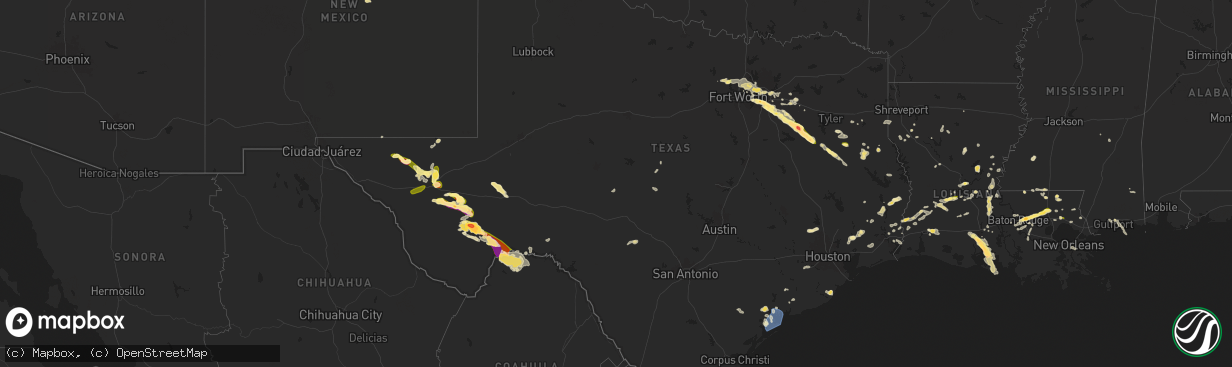
Hail Map in Texas on June 1, 2024
The weather event in Texas on June 1, 2024 includes Hail and Wind maps. 12 states and 558 cities were impacted and suffered possible damage. The total estimated number of properties impacted is 37,735.
Want more than just the map?
Turn this storm into a full workflow.
- Owner + property data so you know who to knock
- OnDemand branded weather history reports to win the "did we even have hail?" argument
- RoofTrace estimate so reps stop guessing numbers at the door
Bought this map? Upgrade within 7 days and we'll credit the $230. (10-15 min setup call)
Hail
Wind
37,735
Estimated number of impacted properties by a 1.00" hail or larger5,728
Estimated number of impacted properties by a 1.75" hail or larger4,353
Estimated number of impacted properties by a 2.50" hail or largerStorm reports in Texas
Texas
| Date | Description |
|---|---|
| 06/01/20246:56 PM CDT | Widespread trees and powerlines downed across mainly the northern half of the county. |
| 06/01/20246:25 PM CDT | Widespread trees and powerlines downed throughout the county. |
| 06/01/20246:23 PM CDT | Trees down on hwy 7 west of martinsville. |
| 06/01/20246:20 PM CDT | Delayed report of trees down along highway 69 between rusk and alto. |
| 06/01/20245:56 PM CDT | Multiple power poles found snapped along a nearly one mile span on us67 near hovey rd. Time estimated from radar. |
| 06/01/20245:40 PM CDT | Widespread trees and powerlines downed across the entire county. |
| 06/01/20245:32 PM CDT | A local report indicates 1.00 inch wind near Reklaw |
| 06/01/20245:21 PM CDT | Mesonet station 91 dell city |
| 06/01/20245:19 PM CDT | Tress down at the intersection of fm 1971 and fm 95. |
| 06/01/20245:11 PM CDT | Power lines down on tx hwy 43 near martin creek lake. |
| 06/01/20245:10 PM CDT | Trees down at the intersection of tx hwy 43 and cr 2144. |
| 06/01/20245:10 PM CDT | Trained spotter reported quarter size hail on the east side of lake striker. |
| 06/01/20245:06 PM CDT | This tornado was reported and photographed as a dusty circulation lasting about 10 minutes in rural pecos county west of hovey road. This circulation may have been a la |
| 06/01/20245:00 PM CDT | Montalba vfd reports golf ball hail. Relayed by emergency management. |
| 06/01/20244:59 PM CDT | Trees down at the intersection of tx hwy 43 and fm 1251. |
| 06/01/20244:47 PM CDT | Tree down on the southbound lane of us hwy 259 at cr 146 south of kilgore. |
| 06/01/20244:40 PM CDT | Tree down on fm 2089 just north of the intersection with fm 838 south of overton. |
| 06/01/20244:22 PM CDT | Sheriffs office reported trees down at fm 757 and 2767 and in multiple places along fm 757 throughout smith county. |
| 06/01/20244:06 PM CDT | Quarter sized hail reported by a trained spotter. |
| 06/01/20244:05 PM CDT | Relayed viewer photo of baseball hail. Time estimated. |
| 06/01/20244:02 PM CDT | Trained spotter estimates 70 mph wind gust. Multiple trees blown over and metal fence bent. |
| 06/01/20244:02 PM CDT | A local report indicates 2.50 inch wind near Malakoff |
| 06/01/20243:57 PM CDT | Report from mping: quarter |
| 06/01/20243:56 PM CDT | Report from mping: hen egg |
| 06/01/20243:51 PM CDT | Report from mping: quarter |
| 06/01/20243:44 PM CDT | Trees down on power lines near circle drive in lindale. |
| 06/01/20243:43 PM CDT | Report from mping: quarter |
| 06/01/20241:58 PM CDT | Private weather station measured 59 mph wind gust near dayton. |
| 06/01/202412:58 PM CDT | Photos of wind damage involving trees... A metal awning... And fencing around the irving pd. Time estimated by radar. |
| 06/01/202411:55 AM CDT | Quarter size hail reported just southeast of boyd... Tx. |
| 06/01/202410:36 AM CDT | Report from mping: 1-inch tree limbs broken; shingles blown off. |
| 06/01/202410:32 AM CDT | A huge tree uprooted and 3 windows broken at a residence. |
| 06/01/202410:30 AM CDT | Corrects previous tstm wnd gst report from 10 wsw palacios. El campo beach road weatherflow site measured a 64 mph wind gust. |
| 06/01/202410:09 AM CDT | Two boats were capsized just offshore. An rv and shed were completely destroyed along state highway 316. A home along brighton ave lost a few shingles and farther south |
| 06/01/20249:55 AM CDT | Tempest weather station in southwest port lavaca measured a wind gust of 62 mph at 9:55 am cdt. |
| 06/01/20249:43 AM CDT | [landspout] emergency manager reported landspout near the intersection of county road 223 and county road 523. |
| 05/31/202411:30 PM CDT | Report came from social media. |
| 05/31/202411:25 PM CDT | Mesonet station twb98 gray ranch. |
| 05/31/202410:55 PM CDT | Timing was adjusted by radar due to call being after leaving the area of the storm. |
| 05/31/202410:45 PM CDT | Mesonet station ur206 16.5 nw langtry |
| 05/31/20248:49 PM CDT | This was likely caused by an outflow boundary ahead of severe thunderstorms to the north. Mesonet station emnt2 elephant mtn wma raws. |
| 05/31/20247:33 PM CDT | Widespread trees and powerlines downed across the entire county. |
| 05/31/20247:30 PM CDT | A local report indicates 3.00 inch wind near 7 E Marathon |
| 05/31/20247:25 PM CDT | Corrects previous hail report from 4 ne marathon. |
| 05/31/20247:25 PM CDT | A local report indicates 3.00 inch wind near 4 NE Marathon |
| 05/31/20247:22 PM CDT | Mesonet station ur285 4.4 e marathon |
All States Impacted by Hail Map on June 1, 2024
Cities Impacted by Hail Map on June 1, 2024
- Hemingford, NE
- Alliance, NE
- Arthur, NE
- North Platte, NE
- Stapleton, NE
- Maxwell, NE
- Ashby, NE
- Oelrichs, SD
- Arnold, NE
- Hyannis, NE
- Goliad, TX
- Callaway, NE
- Whitman, NE
- Lexington, NE
- Victoria, TX
- Cozad, NE
- Brady, NE
- Edna, TX
- Port Lavaca, TX
- Bloomington, TX
- Oconto, NE
- Palacios, TX
- Lolita, TX
- Eddyville, NE
- Bay City, TX
- Elwood, NE
- Freeport, TX
- Wilmer, AL
- Bertrand, NE
- Smithfield, NE
- Seadrift, TX
- Port O'Connor, TX
- El Campo, TX
- Louise, TX
- Leakesville, MS
- Lucedale, MS
- Clute, TX
- Boyd, TX
- Paradise, TX
- Azle, TX
- Newark, TX
- Rhome, TX
- Springtown, TX
- Gulfport, MS
- Biloxi, MS
- Argyle, TX
- Rosenberg, TX
- Justin, TX
- Fort Worth, TX
- Haslet, TX
- Roanoke, TX
- Keller, TX
- Southlake, TX
- Richmond, TX
- Grapevine, TX
- Colleyville, TX
- Flower Mound, TX
- North Richland Hills, TX
- Irving, TX
- Dallas, TX
- Coppell, TX
- Carrollton, TX
- Euless, TX
- Lewisville, TX
- Lake Charles, LA
- Devers, TX
- Beaumont, TX
- Orange, TX
- Iowa, LA
- Vidor, TX
- Long Beach, MS
- Hurst, TX
- Dayton, TX
- Bridge City, TX
- Rockwall, TX
- Rowlett, TX
- Mesquite, TX
- Buna, TX
- Bedford, TX
- Garland, TX
- Liberty, TX
- Forney, TX
- Sunnyvale, TX
- Violet, LA
- Deweyville, TX
- Plaquemine, LA
- Grand Prairie, TX
- Canton, TX
- Vinton, LA
- Hull, TX
- Duncanville, TX
- Desoto, TX
- Starks, LA
- Calhan, CO
- Saint Gabriel, LA
- Merryville, LA
- Belle Chasse, LA
- New Orleans, LA
- Saint Bernard, LA
- Plantersville, TX
- Magnolia, TX
- Lancaster, TX
- Hutchins, TX
- Wilmer, TX
- Ramah, CO
- Singer, LA
- Braithwaite, LA
- Batson, TX
- Montgomery, TX
- Cedar Hill, TX
- Terrell, TX
- Kaufman, TX
- Pinehurst, TX
- Kountze, TX
- Saratoga, TX
- Red Oak, TX
- Ferris, TX
- Wills Point, TX
- Dequincy, LA
- Simla, CO
- Welsh, LA
- Ennis, TX
- Seagoville, TX
- Scurry, TX
- Donaldsonville, LA
- Gonzales, LA
- Darrow, LA
- Sorrento, LA
- Palmer, TX
- Kemp, TX
- Cimarron, NM
- Fred, TX
- Longville, LA
- Saint James, LA
- Rosser, TX
- Ragley, LA
- Silsbee, TX
- Spurger, TX
- Belle Rose, LA
- Rapid City, SD
- Eunice, LA
- Basile, LA
- Pritchett, CO
- Deridder, LA
- Addis, LA
- Baton Rouge, LA
- Okeene, OK
- Kirbyville, TX
- Chatfield, TX
- Bell City, LA
- Raton, NM
- Mabank, TX
- Eustace, TX
- Trinidad, TX
- Quinter, KS
- Bucklin, KS
- Fairburn, SD
- Utica, KS
- Trenton, NE
- Minneola, KS
- Culbertson, NE
- Rushville, NE
- Keystone, NE
- Ogallala, NE
- Ness City, KS
- Bingham, NE
- Beeler, KS
- Wauneta, NE
- Atwood, KS
- Ford, KS
- Pine Ridge, SD
- Grainfield, KS
- Protection, KS
- Hayes Center, NE
- Palisade, NE
- Ellsworth, NE
- Herndon, KS
- Elsie, NE
- Hoxie, KS
- Jetmore, KS
- Caputa, SD
- Selden, KS
- Paxton, NE
- Hermosa, SD
- Spearville, KS
- Dry Creek, LA
- Kinder, LA
- Las Animas, CO
- Woodville, TX
- Malakoff, TX
- Limon, CO
- Jasper, TX
- Bushnell, NE
- Arnaudville, LA
- Pearl River, LA
- Prairieville, LA
- Ville Platte, LA
- Mittie, LA
- Newton, TX
- Pitkin, LA
- Athens, TX
- Denham Springs, LA
- Genoa, CO
- Oakdale, LA
- Balmorhea, TX
- Walker, LA
- Greenwell Springs, LA
- Mandeville, LA
- Breaux Bridge, LA
- Livingston, LA
- Montalba, TX
- Holden, LA
- Lindon, CO
- Granada, CO
- Holly, CO
- Tennessee Colony, TX
- Ponchatoula, LA
- Port Barre, LA
- Branson, CO
- Port Allen, LA
- Troup, TX
- Cheyenne, WY
- Las Vegas, NM
- Sapello, NM
- Saint Landry, LA
- Salt Flat, TX
- Sidney, NE
- Fort Davis, TX
- Palestine, TX
- Fort Stockton, TX
- Madisonville, LA
- Melville, LA
- Palmetto, LA
- Krotz Springs, LA
- Encino, NM
- Albany, LA
- Independence, LA
- Blessing, TX
- Glenmora, LA
- Burns, WY
- Warren, TX
- Bunkie, LA
- Tickfaw, LA
- Amite, LA
- Covington, LA
- Lecompte, LA
- Meriden, WY
- Forest Hill, LA
- Mount Enterprise, TX
- Garrison, TX
- Henderson, TX
- Jacksonville, TX
- Woodworth, LA
- Evergreen, LA
- Syracuse, KS
- Kendall, KS
- Deerfield, KS
- Lakin, KS
- Van Horn, TX
- Rusk, TX
- Reklaw, TX
- Laneville, TX
- Saint Martinville, LA
- Cottonport, LA
- Plaucheville, LA
- Lagrange, WY
- Center, TX
- Bush, LA
- Tatum, TX
- Holcomb, KS
- Cushing, TX
- Garden City, KS
- Sterling, CO
- Otis, CO
- Akron, CO
- Kentwood, LA
- Greensburg, LA
- Alexandria, LA
- Batchelor, LA
- Simmesport, LA
- Dell City, TX
- Iliff, CO
- Franklinton, LA
- Springfield, CO
- Wilson, LA
- Loranger, LA
- Valentine, TX
- Pecos, TX
- Alpine, TX
- Lettsworth, LA
- Padroni, CO
- De Berry, TX
- Overton, TX
- Kilgore, TX
- Moreauville, LA
- Clinton, LA
- Folsom, LA
- Cloutierville, LA
- Lena, LA
- Saint Francisville, LA
- Jena, LA
- Nacogdoches, TX
- Bogalusa, LA
- Leoti, KS
- Keithville, LA
- Monterey, LA
- Mount Hermon, LA
- Watrous, NM
- Alto, TX
- Valmora, NM
- Jonesville, LA
- Marksville, LA
- Wells, TX
- Acme, LA
- Liberty, MS
- Gering, NE
- Lyman, NE
- Brusly, LA
- Marienthal, KS
- Mansfield, LA
- Fleming, CO
- Vidalia, LA
- Osyka, MS
- Scott City, KS
- Atwood, CO
- Pollock, LA
- Saint Amant, LA
- Torrington, WY
- Trementina, NM
- Manter, KS
- Cimarron, KS
- Healy, KS
- Marathon, TX
- Sedgwick, CO
- Trout, LA
- Haxtun, CO
- Morrill, NE
- Coushatta, LA
- Julesburg, CO
- Ferriday, LA
- Sicily Island, LA
- Crook, CO
- Harrison, NE
- Georgetown, LA
- Tullos, LA
- Burlington, OK
- Pollok, TX
- Pelican, LA
- Dighton, KS
- Olla, LA
- Campti, LA
- Amorita, OK
- Campo, CO
- Saline, LA
- Broadwater, NE
- Rolla, KS
- Bridgeport, NE
- Goodwell, OK
- Meadville, MS
- McCall Creek, MS
- Goldonna, LA
- Bronson, TX
- Pineland, TX
- Hay Springs, NE
- Chadron, NE
- Guymon, OK
- Dodson, LA
- Manchester, OK
- Oshkosh, NE
- Bay Springs, MS
- Union Church, MS
- Arnold, KS
- Plains, KS
- Anthony, KS
- Copeland, KS
- Montezuma, KS
- Ransom, KS
- Marsland, NE
- Mentone, TX
- Hooker, OK
- Provencal, LA
- Wakeeney, KS
- Brownell, KS
- Ellis, KS
- Dryden, TX
- Gordon, NE
- Hays, KS
- Champion, NE
- Meade, KS
- Calhoun, LA
- Raleigh, MS
- Batesland, SD
- Gruver, TX
- Hardesty, OK
- Spearman, TX
- Victoria, KS
- Martin, SD
- Gate, OK
- Wounded Knee, SD
- Gorham, KS
- Walker, KS
- Allen, SD
- Stockville, NE
- Curtis, NE
- Russell, KS
- Valentine, NE
- Maywood, NE
- Perryton, TX
- Oglala, SD
- Buffalo, OK
- Kyle, SD
- Comstock, TX
- Manderson, SD
- Purdum, NE
- Imperial, TX
- Ulysses, KS
- Moorefield, NE
- Brewster, NE
- Eustis, NE
- Johnson, KS
- Moscow, KS
- Arapahoe, NE
- Hugoton, KS
- Sugartown, LA
- Mooreland, OK
- Beaver City, NE
- Edison, NE
- Oberlin, LA
- Ainsworth, NE
- Newcastle, WY
- Elton, LA
- Ewing, NE
- Bristow, NE
- Liberal, KS
- Hubbell, NE
- Menard, TX
- Tyrone, OK
- Hebron, NE
- Leakey, TX
- Duson, LA
- Rayne, LA
- Carleton, NE
- Hunt, TX
- Clifton, KS
- Reynolds, NE
- Geneva, NE
- Silver Creek, NE
- Turpin, OK
- Linn, KS
- Morrowville, KS
- Maurice, LA
- Lafayette, LA
- Mountain Home, TX
- Patterson, LA
- Palmer, KS
- Clarks, NE
- Osceola, NE
- Gilead, NE
- Youngsville, LA
- Washburn, ND
- Seneca, SD
- Fairbury, NE
- Belvidere, NE
- Bruning, NE
- Enterprise, KS
- Abilene, KS
- Abbeville, LA
- Delcambre, LA
- Erath, LA
- New Iberia, LA
- Chapman, KS
- Mahaska, KS
- Green, KS
- Porcupine, SD
- Clearwater, NE
- Strang, NE
- Greenleaf, KS
- Broussard, LA
- Harrisburg, NE
- Ohiowa, NE
- Forgan, OK
- Endicott, NE
- Faulkton, SD
- Woodbine, KS
- Randolph, KS
- Tilden, NE
- Jeanerette, LA
- Franklin, LA
- Hollenberg, KS
- Marion, KS
- Clay Center, KS
- Junction City, KS
- Ipswich, SD
- White City, KS
- Morganville, KS
- Haddam, KS
- Washington, KS
- Wanblee, SD
- Elgin, NE
- Oakdale, NE
- Mansfield, SD
- Lost Springs, KS
- Herington, KS
- Lincolnville, KS
- Leonardville, KS
- Barnes, KS
- Grinnell, KS
- Voca, TX
- Brady, TX
- Gove, KS
- Dwight, KS
- Meadow Grove, NE
- Miami, TX
- Albion, NE
- Ashley, ND
- Olsburg, KS
- Frankfort, KS
- Westmoreland, KS
- Rochelle, TX
- Dodge City, KS
- Pampa, TX
- Monroe, NE
- Newman Grove, NE
- Forbes, ND
- Alta Vista, KS
- Petersburg, NE
- Ellendale, ND
- Fort Riley, KS
- Platte Center, NE
- Humphrey, NE
- Hope, KS
- Lindsay, NE
- Brownwood, TX
- Brookesmith, TX
- Council Grove, KS
- Wilsey, KS
- Columbus, NE
- Madison, NE
- Leigh, NE
- Schuyler, NE
- Creston, NE
- Linwood, NE
- Clarkson, NE
- Morse Bluff, NE
- Rosston, OK
- North Bend, NE
- Shamrock, TX
- Dodge, NE
- Rogers, NE
- Abie, NE
- David City, NE
- Bruno, NE
- Prague, NE
- McCook, NE
- Fordoche, LA
- Morganza, LA
- Shickley, NE
- Milligan, NE


