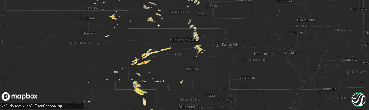
Hail Map in Kansas on June 1, 2024
The weather event in Kansas on June 1, 2024 includes Hail and Wind maps. 12 states and 558 cities were impacted and suffered possible damage. The total estimated number of properties impacted is 12,709.
Want more than just the map?
Turn this storm into a full workflow.
- Owner + property data so you know who to knock
- OnDemand branded weather history reports to win the "did we even have hail?" argument
- RoofTrace estimate so reps stop guessing numbers at the door
Bought this map? Upgrade within 7 days and we'll credit the $230. (10-15 min setup call)
Hail
Wind
12,709
Estimated number of impacted properties by a 1.00" hail or larger3,046
Estimated number of impacted properties by a 1.75" hail or larger180
Estimated number of impacted properties by a 2.50" hail or largerStorm reports in Kansas
Kansas
| Date | Description |
|---|---|
| 06/01/20246:05 PM CDT | Report made via social media. |
| 06/01/20246:00 PM CDT | Report made via social media. |
| 06/01/20246:00 PM CDT | A local report indicates 1.75 inch wind near 2 N Garden City |
| 06/01/20246:00 PM CDT | A local report indicates 1.50 inch wind near 2 N Garden City |
| 06/01/20246:00 PM CDT | Report made via social media. |
| 06/01/20245:45 PM CDT | Report made via social media. |
| 06/01/20245:43 PM CDT | Report made via social media. |
| 06/01/20245:41 PM CDT | A local report indicates 1.50 inch wind near Holcomb |
| 06/01/20245:30 PM CDT | Relayed by emergency management. |
| 06/01/20245:23 PM CDT | A local report indicates 1.00 inch wind near Lakin |
| 06/01/20245:09 PM CDT | Photo on social media. |
| 06/01/20245:00 PM CDT | A local report indicates 1.00 inch wind near Syracuse |
| 06/01/20244:48 AM CDT | A local report indicates 1.25 inch wind near White City |
| 06/01/20244:48 AM CDT | Social media photo. Delayed report. |
| 06/01/20243:40 AM CDT | Report from social media with picture. |
| 06/01/20243:34 AM CDT | Large tree limb down |
| 06/01/20243:29 AM CDT | Delayed report. Large tree branch 1-2 feet in diameter broken off tree. Time estimated from radar. |
| 06/01/20242:55 AM CDT | A local report indicates 1.00 inch wind near Scott City |
| 05/31/20249:55 PM CDT | Report made via social media. |
| 05/31/20247:30 PM CDT | Reported by fire department. |
All States Impacted by Hail Map on June 1, 2024
Cities Impacted by Hail Map on June 1, 2024
- Hemingford, NE
- Alliance, NE
- Arthur, NE
- North Platte, NE
- Stapleton, NE
- Maxwell, NE
- Ashby, NE
- Oelrichs, SD
- Arnold, NE
- Hyannis, NE
- Goliad, TX
- Callaway, NE
- Whitman, NE
- Lexington, NE
- Victoria, TX
- Cozad, NE
- Brady, NE
- Edna, TX
- Port Lavaca, TX
- Bloomington, TX
- Oconto, NE
- Palacios, TX
- Lolita, TX
- Eddyville, NE
- Bay City, TX
- Elwood, NE
- Freeport, TX
- Wilmer, AL
- Bertrand, NE
- Smithfield, NE
- Seadrift, TX
- Port O'Connor, TX
- El Campo, TX
- Louise, TX
- Leakesville, MS
- Lucedale, MS
- Clute, TX
- Boyd, TX
- Paradise, TX
- Azle, TX
- Newark, TX
- Rhome, TX
- Springtown, TX
- Gulfport, MS
- Biloxi, MS
- Argyle, TX
- Rosenberg, TX
- Justin, TX
- Fort Worth, TX
- Haslet, TX
- Roanoke, TX
- Keller, TX
- Southlake, TX
- Richmond, TX
- Grapevine, TX
- Colleyville, TX
- Flower Mound, TX
- North Richland Hills, TX
- Irving, TX
- Dallas, TX
- Coppell, TX
- Carrollton, TX
- Euless, TX
- Lewisville, TX
- Lake Charles, LA
- Devers, TX
- Beaumont, TX
- Orange, TX
- Iowa, LA
- Vidor, TX
- Long Beach, MS
- Hurst, TX
- Dayton, TX
- Bridge City, TX
- Rockwall, TX
- Rowlett, TX
- Mesquite, TX
- Buna, TX
- Bedford, TX
- Garland, TX
- Liberty, TX
- Forney, TX
- Sunnyvale, TX
- Violet, LA
- Deweyville, TX
- Plaquemine, LA
- Grand Prairie, TX
- Canton, TX
- Vinton, LA
- Hull, TX
- Duncanville, TX
- Desoto, TX
- Starks, LA
- Calhan, CO
- Saint Gabriel, LA
- Merryville, LA
- Belle Chasse, LA
- New Orleans, LA
- Saint Bernard, LA
- Plantersville, TX
- Magnolia, TX
- Lancaster, TX
- Hutchins, TX
- Wilmer, TX
- Ramah, CO
- Singer, LA
- Braithwaite, LA
- Batson, TX
- Montgomery, TX
- Cedar Hill, TX
- Terrell, TX
- Kaufman, TX
- Pinehurst, TX
- Kountze, TX
- Saratoga, TX
- Red Oak, TX
- Ferris, TX
- Wills Point, TX
- Dequincy, LA
- Simla, CO
- Welsh, LA
- Ennis, TX
- Seagoville, TX
- Scurry, TX
- Donaldsonville, LA
- Gonzales, LA
- Darrow, LA
- Sorrento, LA
- Palmer, TX
- Kemp, TX
- Cimarron, NM
- Fred, TX
- Longville, LA
- Saint James, LA
- Rosser, TX
- Ragley, LA
- Silsbee, TX
- Spurger, TX
- Belle Rose, LA
- Rapid City, SD
- Eunice, LA
- Basile, LA
- Pritchett, CO
- Deridder, LA
- Addis, LA
- Baton Rouge, LA
- Okeene, OK
- Kirbyville, TX
- Chatfield, TX
- Bell City, LA
- Raton, NM
- Mabank, TX
- Eustace, TX
- Trinidad, TX
- Quinter, KS
- Bucklin, KS
- Fairburn, SD
- Utica, KS
- Trenton, NE
- Minneola, KS
- Culbertson, NE
- Rushville, NE
- Keystone, NE
- Ogallala, NE
- Ness City, KS
- Bingham, NE
- Beeler, KS
- Wauneta, NE
- Atwood, KS
- Ford, KS
- Pine Ridge, SD
- Grainfield, KS
- Protection, KS
- Hayes Center, NE
- Palisade, NE
- Ellsworth, NE
- Herndon, KS
- Elsie, NE
- Hoxie, KS
- Jetmore, KS
- Caputa, SD
- Selden, KS
- Paxton, NE
- Hermosa, SD
- Spearville, KS
- Dry Creek, LA
- Kinder, LA
- Las Animas, CO
- Woodville, TX
- Malakoff, TX
- Limon, CO
- Jasper, TX
- Bushnell, NE
- Arnaudville, LA
- Pearl River, LA
- Prairieville, LA
- Ville Platte, LA
- Mittie, LA
- Newton, TX
- Pitkin, LA
- Athens, TX
- Denham Springs, LA
- Genoa, CO
- Oakdale, LA
- Balmorhea, TX
- Walker, LA
- Greenwell Springs, LA
- Mandeville, LA
- Breaux Bridge, LA
- Livingston, LA
- Montalba, TX
- Holden, LA
- Lindon, CO
- Granada, CO
- Holly, CO
- Tennessee Colony, TX
- Ponchatoula, LA
- Port Barre, LA
- Branson, CO
- Port Allen, LA
- Troup, TX
- Cheyenne, WY
- Las Vegas, NM
- Sapello, NM
- Saint Landry, LA
- Salt Flat, TX
- Sidney, NE
- Fort Davis, TX
- Palestine, TX
- Fort Stockton, TX
- Madisonville, LA
- Melville, LA
- Palmetto, LA
- Krotz Springs, LA
- Encino, NM
- Albany, LA
- Independence, LA
- Blessing, TX
- Glenmora, LA
- Burns, WY
- Warren, TX
- Bunkie, LA
- Tickfaw, LA
- Amite, LA
- Covington, LA
- Lecompte, LA
- Meriden, WY
- Forest Hill, LA
- Mount Enterprise, TX
- Garrison, TX
- Henderson, TX
- Jacksonville, TX
- Woodworth, LA
- Evergreen, LA
- Syracuse, KS
- Kendall, KS
- Deerfield, KS
- Lakin, KS
- Van Horn, TX
- Rusk, TX
- Reklaw, TX
- Laneville, TX
- Saint Martinville, LA
- Cottonport, LA
- Plaucheville, LA
- Lagrange, WY
- Center, TX
- Bush, LA
- Tatum, TX
- Holcomb, KS
- Cushing, TX
- Garden City, KS
- Sterling, CO
- Otis, CO
- Akron, CO
- Kentwood, LA
- Greensburg, LA
- Alexandria, LA
- Batchelor, LA
- Simmesport, LA
- Dell City, TX
- Iliff, CO
- Franklinton, LA
- Springfield, CO
- Wilson, LA
- Loranger, LA
- Valentine, TX
- Pecos, TX
- Alpine, TX
- Lettsworth, LA
- Padroni, CO
- De Berry, TX
- Overton, TX
- Kilgore, TX
- Moreauville, LA
- Clinton, LA
- Folsom, LA
- Cloutierville, LA
- Lena, LA
- Saint Francisville, LA
- Jena, LA
- Nacogdoches, TX
- Bogalusa, LA
- Leoti, KS
- Keithville, LA
- Monterey, LA
- Mount Hermon, LA
- Watrous, NM
- Alto, TX
- Valmora, NM
- Jonesville, LA
- Marksville, LA
- Wells, TX
- Acme, LA
- Liberty, MS
- Gering, NE
- Lyman, NE
- Brusly, LA
- Marienthal, KS
- Mansfield, LA
- Fleming, CO
- Vidalia, LA
- Osyka, MS
- Scott City, KS
- Atwood, CO
- Pollock, LA
- Saint Amant, LA
- Torrington, WY
- Trementina, NM
- Manter, KS
- Cimarron, KS
- Healy, KS
- Marathon, TX
- Sedgwick, CO
- Trout, LA
- Haxtun, CO
- Morrill, NE
- Coushatta, LA
- Julesburg, CO
- Ferriday, LA
- Sicily Island, LA
- Crook, CO
- Harrison, NE
- Georgetown, LA
- Tullos, LA
- Burlington, OK
- Pollok, TX
- Pelican, LA
- Dighton, KS
- Olla, LA
- Campti, LA
- Amorita, OK
- Campo, CO
- Saline, LA
- Broadwater, NE
- Rolla, KS
- Bridgeport, NE
- Goodwell, OK
- Meadville, MS
- McCall Creek, MS
- Goldonna, LA
- Bronson, TX
- Pineland, TX
- Hay Springs, NE
- Chadron, NE
- Guymon, OK
- Dodson, LA
- Manchester, OK
- Oshkosh, NE
- Bay Springs, MS
- Union Church, MS
- Arnold, KS
- Plains, KS
- Anthony, KS
- Copeland, KS
- Montezuma, KS
- Ransom, KS
- Marsland, NE
- Mentone, TX
- Hooker, OK
- Provencal, LA
- Wakeeney, KS
- Brownell, KS
- Ellis, KS
- Dryden, TX
- Gordon, NE
- Hays, KS
- Champion, NE
- Meade, KS
- Calhoun, LA
- Raleigh, MS
- Batesland, SD
- Gruver, TX
- Hardesty, OK
- Spearman, TX
- Victoria, KS
- Martin, SD
- Gate, OK
- Wounded Knee, SD
- Gorham, KS
- Walker, KS
- Allen, SD
- Stockville, NE
- Curtis, NE
- Russell, KS
- Valentine, NE
- Maywood, NE
- Perryton, TX
- Oglala, SD
- Buffalo, OK
- Kyle, SD
- Comstock, TX
- Manderson, SD
- Purdum, NE
- Imperial, TX
- Ulysses, KS
- Moorefield, NE
- Brewster, NE
- Eustis, NE
- Johnson, KS
- Moscow, KS
- Arapahoe, NE
- Hugoton, KS
- Sugartown, LA
- Mooreland, OK
- Beaver City, NE
- Edison, NE
- Oberlin, LA
- Ainsworth, NE
- Newcastle, WY
- Elton, LA
- Ewing, NE
- Bristow, NE
- Liberal, KS
- Hubbell, NE
- Menard, TX
- Tyrone, OK
- Hebron, NE
- Leakey, TX
- Duson, LA
- Rayne, LA
- Carleton, NE
- Hunt, TX
- Clifton, KS
- Reynolds, NE
- Geneva, NE
- Silver Creek, NE
- Turpin, OK
- Linn, KS
- Morrowville, KS
- Maurice, LA
- Lafayette, LA
- Mountain Home, TX
- Patterson, LA
- Palmer, KS
- Clarks, NE
- Osceola, NE
- Gilead, NE
- Youngsville, LA
- Washburn, ND
- Seneca, SD
- Fairbury, NE
- Belvidere, NE
- Bruning, NE
- Enterprise, KS
- Abilene, KS
- Abbeville, LA
- Delcambre, LA
- Erath, LA
- New Iberia, LA
- Chapman, KS
- Mahaska, KS
- Green, KS
- Porcupine, SD
- Clearwater, NE
- Strang, NE
- Greenleaf, KS
- Broussard, LA
- Harrisburg, NE
- Ohiowa, NE
- Forgan, OK
- Endicott, NE
- Faulkton, SD
- Woodbine, KS
- Randolph, KS
- Tilden, NE
- Jeanerette, LA
- Franklin, LA
- Hollenberg, KS
- Marion, KS
- Clay Center, KS
- Junction City, KS
- Ipswich, SD
- White City, KS
- Morganville, KS
- Haddam, KS
- Washington, KS
- Wanblee, SD
- Elgin, NE
- Oakdale, NE
- Mansfield, SD
- Lost Springs, KS
- Herington, KS
- Lincolnville, KS
- Leonardville, KS
- Barnes, KS
- Grinnell, KS
- Voca, TX
- Brady, TX
- Gove, KS
- Dwight, KS
- Meadow Grove, NE
- Miami, TX
- Albion, NE
- Ashley, ND
- Olsburg, KS
- Frankfort, KS
- Westmoreland, KS
- Rochelle, TX
- Dodge City, KS
- Pampa, TX
- Monroe, NE
- Newman Grove, NE
- Forbes, ND
- Alta Vista, KS
- Petersburg, NE
- Ellendale, ND
- Fort Riley, KS
- Platte Center, NE
- Humphrey, NE
- Hope, KS
- Lindsay, NE
- Brownwood, TX
- Brookesmith, TX
- Council Grove, KS
- Wilsey, KS
- Columbus, NE
- Madison, NE
- Leigh, NE
- Schuyler, NE
- Creston, NE
- Linwood, NE
- Clarkson, NE
- Morse Bluff, NE
- Rosston, OK
- North Bend, NE
- Shamrock, TX
- Dodge, NE
- Rogers, NE
- Abie, NE
- David City, NE
- Bruno, NE
- Prague, NE
- McCook, NE
- Fordoche, LA
- Morganza, LA
- Shickley, NE
- Milligan, NE


