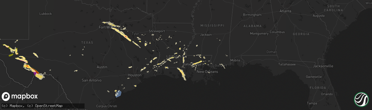
Hail Map in Louisiana on June 1, 2024
The weather event in Louisiana on June 1, 2024 includes Hail and Wind maps. 12 states and 558 cities were impacted and suffered possible damage. The total estimated number of properties impacted is 24,505.
Want more than just the map?
Turn this storm into a full workflow.
- Owner + property data so you know who to knock
- OnDemand branded weather history reports to win the "did we even have hail?" argument
- RoofTrace estimate so reps stop guessing numbers at the door
Bought this map? Upgrade within 7 days and we'll credit the $230. (10-15 min setup call)
Hail
Wind
24,505
Estimated number of impacted properties by a 1.00" hail or larger4,109
Estimated number of impacted properties by a 1.75" hail or larger0
Estimated number of impacted properties by a 2.50" hail or largerStorm reports in Louisiana
Louisiana
| Date | Description |
|---|---|
| 06/01/20246:17 PM CDT | Large oak tree uprooted. 100ft of fences blown over near kingfisher trail in stonewall off of stonewall frierson road. Estimated winds of 60 to 70 mph. |
| 06/01/20246:17 PM CDT | Large oak tree uprooted. 100ft of fences blown over near kingfisher trail in stonewall off of stonewall frierson road. Estimated winds of 60 to 70 mph. |
| 06/01/20246:02 PM CDT | Trees down across the road near the intersection of keithville-keatchie road and hunsicker lane east of the four forks community. |
| 06/01/20245:48 PM CDT | Utility company reports power outages in associated with strong thunderstorm winds. Area observations observed wind gusts up to 30 mph at the time of the outages. |
| 06/01/20245:29 PM CDT | Broadcast media reports trees down in cottonport. Times estimated by radar. |
| 06/01/20245:29 PM CDT | Report of tree down on mouton street in opelousas. Time estimated by radar. |
| 06/01/20245:19 PM CDT | Report of trees and powerlines down on dora road between cottonport and evergreen. Time estimated by radar. |
| 06/01/20245:09 PM CDT | Off duty nws employee reports hail up to quarter size near coquille park in covington. |
| 06/01/20244:57 PM CDT | Utility company reporting numerous power outages in the city of krotz springs as thunderstorms moved through. |
| 06/01/20244:51 PM CDT | Utility company reporting numerous power outages in breaux bridge with thunderstorm passage. |
| 06/01/20244:35 PM CDT | Utility company reports power outages in associated with strong thunderstorm winds. Area observations observed wind gusts 40 to 50 mph at the time of the outages. |
| 06/01/20244:25 PM CDT | Report of trees and powerlines down near walker rd and avants rd in walker. Time estimated by radar. |
| 06/01/20244:19 PM CDT | Photos received of hail up to 1.00 inches in diameter from oakdale. Time estimated by radar. |
| 06/01/20244:14 PM CDT | Video of large tree falling near n corbin road in walker. Relayed by broadcast media. Time estimated by radar. |
| 06/01/20244:05 PM CDT | Picture of an approximately quarter sized hail in walker. Relayed by broadcast media. |
| 06/01/20244:05 PM CDT | Corrects previous hail report from walker. Several reports of approximately quarter size hail from the walker area relayed by broadcast media. |
| 06/01/20243:59 PM CDT | Report from mping: half dollar |
| 06/01/20243:48 PM CDT | Picture of a hailstone with a tape measure just around 1.5 inch/ping pong ball size hail near the intersection of o neal ln & old hammond hwy. Relayed by broadcast medi |
| 06/01/20242:57 AM CDT | Photos on social media showing extensive tree damage at rip van winkle gardens. Time estimated by radar. |
| 06/01/20242:45 AM CDT | Several trees reported down in the champagne subdivision. |
| 06/01/20242:45 AM CDT | Public reported damage evidence to the area that included trees snapped / broken... Chimney tops blown off roof... And downed power lines. Picture evidence shows accumu |
| 06/01/20242:37 AM CDT | Video of quarter size hail. |
| 05/31/20248:52 PM CDT | 911 center reports a tree fell on an 18 wheeler as it was traveling down hwy 1. No injuries. |
| 05/31/20248:22 PM CDT | Utility company reports power outages in association with strong thunderstorm winds. |
| 05/31/20247:55 PM CDT | Several trees downed across the far southern portion of the parish... Especially along hwy 191 near curtis store. |
| 05/31/20247:05 PM CDT | Large limbs down near the intersection of hwy 514 and hwy. 783 west of hall summit. |
All States Impacted by Hail Map on June 1, 2024
Cities Impacted by Hail Map on June 1, 2024
- Hemingford, NE
- Alliance, NE
- Arthur, NE
- North Platte, NE
- Stapleton, NE
- Maxwell, NE
- Ashby, NE
- Oelrichs, SD
- Arnold, NE
- Hyannis, NE
- Goliad, TX
- Callaway, NE
- Whitman, NE
- Lexington, NE
- Victoria, TX
- Cozad, NE
- Brady, NE
- Edna, TX
- Port Lavaca, TX
- Bloomington, TX
- Oconto, NE
- Palacios, TX
- Lolita, TX
- Eddyville, NE
- Bay City, TX
- Elwood, NE
- Freeport, TX
- Wilmer, AL
- Bertrand, NE
- Smithfield, NE
- Seadrift, TX
- Port O'Connor, TX
- El Campo, TX
- Louise, TX
- Leakesville, MS
- Lucedale, MS
- Clute, TX
- Boyd, TX
- Paradise, TX
- Azle, TX
- Newark, TX
- Rhome, TX
- Springtown, TX
- Gulfport, MS
- Biloxi, MS
- Argyle, TX
- Rosenberg, TX
- Justin, TX
- Fort Worth, TX
- Haslet, TX
- Roanoke, TX
- Keller, TX
- Southlake, TX
- Richmond, TX
- Grapevine, TX
- Colleyville, TX
- Flower Mound, TX
- North Richland Hills, TX
- Irving, TX
- Dallas, TX
- Coppell, TX
- Carrollton, TX
- Euless, TX
- Lewisville, TX
- Lake Charles, LA
- Devers, TX
- Beaumont, TX
- Orange, TX
- Iowa, LA
- Vidor, TX
- Long Beach, MS
- Hurst, TX
- Dayton, TX
- Bridge City, TX
- Rockwall, TX
- Rowlett, TX
- Mesquite, TX
- Buna, TX
- Bedford, TX
- Garland, TX
- Liberty, TX
- Forney, TX
- Sunnyvale, TX
- Violet, LA
- Deweyville, TX
- Plaquemine, LA
- Grand Prairie, TX
- Canton, TX
- Vinton, LA
- Hull, TX
- Duncanville, TX
- Desoto, TX
- Starks, LA
- Calhan, CO
- Saint Gabriel, LA
- Merryville, LA
- Belle Chasse, LA
- New Orleans, LA
- Saint Bernard, LA
- Plantersville, TX
- Magnolia, TX
- Lancaster, TX
- Hutchins, TX
- Wilmer, TX
- Ramah, CO
- Singer, LA
- Braithwaite, LA
- Batson, TX
- Montgomery, TX
- Cedar Hill, TX
- Terrell, TX
- Kaufman, TX
- Pinehurst, TX
- Kountze, TX
- Saratoga, TX
- Red Oak, TX
- Ferris, TX
- Wills Point, TX
- Dequincy, LA
- Simla, CO
- Welsh, LA
- Ennis, TX
- Seagoville, TX
- Scurry, TX
- Donaldsonville, LA
- Gonzales, LA
- Darrow, LA
- Sorrento, LA
- Palmer, TX
- Kemp, TX
- Cimarron, NM
- Fred, TX
- Longville, LA
- Saint James, LA
- Rosser, TX
- Ragley, LA
- Silsbee, TX
- Spurger, TX
- Belle Rose, LA
- Rapid City, SD
- Eunice, LA
- Basile, LA
- Pritchett, CO
- Deridder, LA
- Addis, LA
- Baton Rouge, LA
- Okeene, OK
- Kirbyville, TX
- Chatfield, TX
- Bell City, LA
- Raton, NM
- Mabank, TX
- Eustace, TX
- Trinidad, TX
- Quinter, KS
- Bucklin, KS
- Fairburn, SD
- Utica, KS
- Trenton, NE
- Minneola, KS
- Culbertson, NE
- Rushville, NE
- Keystone, NE
- Ogallala, NE
- Ness City, KS
- Bingham, NE
- Beeler, KS
- Wauneta, NE
- Atwood, KS
- Ford, KS
- Pine Ridge, SD
- Grainfield, KS
- Protection, KS
- Hayes Center, NE
- Palisade, NE
- Ellsworth, NE
- Herndon, KS
- Elsie, NE
- Hoxie, KS
- Jetmore, KS
- Caputa, SD
- Selden, KS
- Paxton, NE
- Hermosa, SD
- Spearville, KS
- Dry Creek, LA
- Kinder, LA
- Las Animas, CO
- Woodville, TX
- Malakoff, TX
- Limon, CO
- Jasper, TX
- Bushnell, NE
- Arnaudville, LA
- Pearl River, LA
- Prairieville, LA
- Ville Platte, LA
- Mittie, LA
- Newton, TX
- Pitkin, LA
- Athens, TX
- Denham Springs, LA
- Genoa, CO
- Oakdale, LA
- Balmorhea, TX
- Walker, LA
- Greenwell Springs, LA
- Mandeville, LA
- Breaux Bridge, LA
- Livingston, LA
- Montalba, TX
- Holden, LA
- Lindon, CO
- Granada, CO
- Holly, CO
- Tennessee Colony, TX
- Ponchatoula, LA
- Port Barre, LA
- Branson, CO
- Port Allen, LA
- Troup, TX
- Cheyenne, WY
- Las Vegas, NM
- Sapello, NM
- Saint Landry, LA
- Salt Flat, TX
- Sidney, NE
- Fort Davis, TX
- Palestine, TX
- Fort Stockton, TX
- Madisonville, LA
- Melville, LA
- Palmetto, LA
- Krotz Springs, LA
- Encino, NM
- Albany, LA
- Independence, LA
- Blessing, TX
- Glenmora, LA
- Burns, WY
- Warren, TX
- Bunkie, LA
- Tickfaw, LA
- Amite, LA
- Covington, LA
- Lecompte, LA
- Meriden, WY
- Forest Hill, LA
- Mount Enterprise, TX
- Garrison, TX
- Henderson, TX
- Jacksonville, TX
- Woodworth, LA
- Evergreen, LA
- Syracuse, KS
- Kendall, KS
- Deerfield, KS
- Lakin, KS
- Van Horn, TX
- Rusk, TX
- Reklaw, TX
- Laneville, TX
- Saint Martinville, LA
- Cottonport, LA
- Plaucheville, LA
- Lagrange, WY
- Center, TX
- Bush, LA
- Tatum, TX
- Holcomb, KS
- Cushing, TX
- Garden City, KS
- Sterling, CO
- Otis, CO
- Akron, CO
- Kentwood, LA
- Greensburg, LA
- Alexandria, LA
- Batchelor, LA
- Simmesport, LA
- Dell City, TX
- Iliff, CO
- Franklinton, LA
- Springfield, CO
- Wilson, LA
- Loranger, LA
- Valentine, TX
- Pecos, TX
- Alpine, TX
- Lettsworth, LA
- Padroni, CO
- De Berry, TX
- Overton, TX
- Kilgore, TX
- Moreauville, LA
- Clinton, LA
- Folsom, LA
- Cloutierville, LA
- Lena, LA
- Saint Francisville, LA
- Jena, LA
- Nacogdoches, TX
- Bogalusa, LA
- Leoti, KS
- Keithville, LA
- Monterey, LA
- Mount Hermon, LA
- Watrous, NM
- Alto, TX
- Valmora, NM
- Jonesville, LA
- Marksville, LA
- Wells, TX
- Acme, LA
- Liberty, MS
- Gering, NE
- Lyman, NE
- Brusly, LA
- Marienthal, KS
- Mansfield, LA
- Fleming, CO
- Vidalia, LA
- Osyka, MS
- Scott City, KS
- Atwood, CO
- Pollock, LA
- Saint Amant, LA
- Torrington, WY
- Trementina, NM
- Manter, KS
- Cimarron, KS
- Healy, KS
- Marathon, TX
- Sedgwick, CO
- Trout, LA
- Haxtun, CO
- Morrill, NE
- Coushatta, LA
- Julesburg, CO
- Ferriday, LA
- Sicily Island, LA
- Crook, CO
- Harrison, NE
- Georgetown, LA
- Tullos, LA
- Burlington, OK
- Pollok, TX
- Pelican, LA
- Dighton, KS
- Olla, LA
- Campti, LA
- Amorita, OK
- Campo, CO
- Saline, LA
- Broadwater, NE
- Rolla, KS
- Bridgeport, NE
- Goodwell, OK
- Meadville, MS
- McCall Creek, MS
- Goldonna, LA
- Bronson, TX
- Pineland, TX
- Hay Springs, NE
- Chadron, NE
- Guymon, OK
- Dodson, LA
- Manchester, OK
- Oshkosh, NE
- Bay Springs, MS
- Union Church, MS
- Arnold, KS
- Plains, KS
- Anthony, KS
- Copeland, KS
- Montezuma, KS
- Ransom, KS
- Marsland, NE
- Mentone, TX
- Hooker, OK
- Provencal, LA
- Wakeeney, KS
- Brownell, KS
- Ellis, KS
- Dryden, TX
- Gordon, NE
- Hays, KS
- Champion, NE
- Meade, KS
- Calhoun, LA
- Raleigh, MS
- Batesland, SD
- Gruver, TX
- Hardesty, OK
- Spearman, TX
- Victoria, KS
- Martin, SD
- Gate, OK
- Wounded Knee, SD
- Gorham, KS
- Walker, KS
- Allen, SD
- Stockville, NE
- Curtis, NE
- Russell, KS
- Valentine, NE
- Maywood, NE
- Perryton, TX
- Oglala, SD
- Buffalo, OK
- Kyle, SD
- Comstock, TX
- Manderson, SD
- Purdum, NE
- Imperial, TX
- Ulysses, KS
- Moorefield, NE
- Brewster, NE
- Eustis, NE
- Johnson, KS
- Moscow, KS
- Arapahoe, NE
- Hugoton, KS
- Sugartown, LA
- Mooreland, OK
- Beaver City, NE
- Edison, NE
- Oberlin, LA
- Ainsworth, NE
- Newcastle, WY
- Elton, LA
- Ewing, NE
- Bristow, NE
- Liberal, KS
- Hubbell, NE
- Menard, TX
- Tyrone, OK
- Hebron, NE
- Leakey, TX
- Duson, LA
- Rayne, LA
- Carleton, NE
- Hunt, TX
- Clifton, KS
- Reynolds, NE
- Geneva, NE
- Silver Creek, NE
- Turpin, OK
- Linn, KS
- Morrowville, KS
- Maurice, LA
- Lafayette, LA
- Mountain Home, TX
- Patterson, LA
- Palmer, KS
- Clarks, NE
- Osceola, NE
- Gilead, NE
- Youngsville, LA
- Washburn, ND
- Seneca, SD
- Fairbury, NE
- Belvidere, NE
- Bruning, NE
- Enterprise, KS
- Abilene, KS
- Abbeville, LA
- Delcambre, LA
- Erath, LA
- New Iberia, LA
- Chapman, KS
- Mahaska, KS
- Green, KS
- Porcupine, SD
- Clearwater, NE
- Strang, NE
- Greenleaf, KS
- Broussard, LA
- Harrisburg, NE
- Ohiowa, NE
- Forgan, OK
- Endicott, NE
- Faulkton, SD
- Woodbine, KS
- Randolph, KS
- Tilden, NE
- Jeanerette, LA
- Franklin, LA
- Hollenberg, KS
- Marion, KS
- Clay Center, KS
- Junction City, KS
- Ipswich, SD
- White City, KS
- Morganville, KS
- Haddam, KS
- Washington, KS
- Wanblee, SD
- Elgin, NE
- Oakdale, NE
- Mansfield, SD
- Lost Springs, KS
- Herington, KS
- Lincolnville, KS
- Leonardville, KS
- Barnes, KS
- Grinnell, KS
- Voca, TX
- Brady, TX
- Gove, KS
- Dwight, KS
- Meadow Grove, NE
- Miami, TX
- Albion, NE
- Ashley, ND
- Olsburg, KS
- Frankfort, KS
- Westmoreland, KS
- Rochelle, TX
- Dodge City, KS
- Pampa, TX
- Monroe, NE
- Newman Grove, NE
- Forbes, ND
- Alta Vista, KS
- Petersburg, NE
- Ellendale, ND
- Fort Riley, KS
- Platte Center, NE
- Humphrey, NE
- Hope, KS
- Lindsay, NE
- Brownwood, TX
- Brookesmith, TX
- Council Grove, KS
- Wilsey, KS
- Columbus, NE
- Madison, NE
- Leigh, NE
- Schuyler, NE
- Creston, NE
- Linwood, NE
- Clarkson, NE
- Morse Bluff, NE
- Rosston, OK
- North Bend, NE
- Shamrock, TX
- Dodge, NE
- Rogers, NE
- Abie, NE
- David City, NE
- Bruno, NE
- Prague, NE
- McCook, NE
- Fordoche, LA
- Morganza, LA
- Shickley, NE
- Milligan, NE


