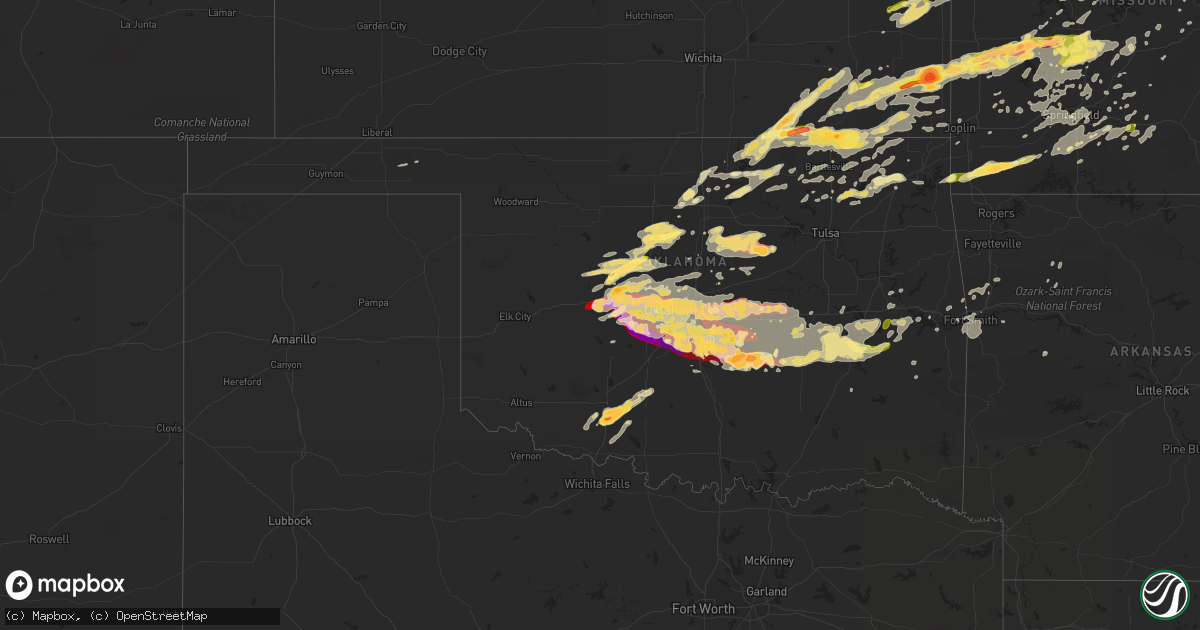
Hail Map in Oklahoma on May 31, 2013
Get this storm
May 31 map
$229
one time, instant access
Download today. No call, no setup
Keep the $229
Bought the map and want the full workflow? Apply the entire $229 to a subscription within 7 days. None of it is wasted.
Every map, not just this one
This buys you this map. Subscription and you get every map we run, in the markets you choose from a few cities to whole states to nationwide. Plus real-time alerts the moment a storm fires.
Contact data
Name, contact info, occupancy, even credit band for addresses in the footprint. You go from where it hit to who to call.
Become the source they trust
Unlimited branding weather history reports on demand. You already have the documented answer ready for the property owner, and you are the one who showed up with it.
Property data and RoofTrace estimates
Pull up any address you have got, its value and the exact code rules for that jurisdiction, straight from One Click Code. Then RoofTrace estimates the squares, pitch, and roof value, priced the way you price.
Storm reports in Oklahoma
Oklahoma
| Date | Description |
|---|---|
| 05/31/20136:59 PM CDT | Tree uprooted |
| 05/31/20136:55 PM CDT | A local report indicates 1.75 inch wind near N YUKON |
| 05/31/20136:55 PM CDT | Numerous trees damaged. |
| 05/31/20136:45 PM CDT | Hefner and council rd |
| 05/31/20136:38 PM CDT | This tornado damaged the roof of a home and uprooted several trees. |
| 05/31/20136:35 PM CDT | Reported via nssl shave project. |
| 05/31/20136:35 PM CDT | Reported via nssl shave project. |
| 05/31/20136:30 PM CDT | Reported via nssl shave project. |
| 05/31/20136:30 PM CDT | Tornado occurred mainly over open country but the survey team found two snapped power poles in an area with a very strong radar signature. |
| 05/31/20136:30 PM CDT | Reported via nssl shave project. |
| 05/31/20136:30 PM CDT | A local report indicates 2.50 inch wind near 6 ESE LAWTON |
| 05/31/20136:30 PM CDT | Reported via nssl shave project. |
| 05/31/20136:25 PM CDT | Brief ef-1 tornado began at lightning creek park then travelled southeastward to the intersections of straka terr. And western ave. |
| 05/31/20136:21 PM CDT | A local report indicates 71 MPH wind near WILL ROGERS AIRPORT |
| 05/31/20136:20 PM CDT | Reported via nssl shave project. |
| 05/31/20136:18 PM CDT | Reported by a storm chaser and was strongly supported by radar. Survey team found no damage as it remained over open country. |
| 05/31/20136:10 PM CDT | Reported via nssl shave project. |
| 05/31/20136:05 PM CDT | Assigned a preliminary rating of ef-3. Long track tornado caused extensive damage in the el reno and union city areas. |
| 05/31/20136:00 PM CDT | Reported via nssl shave project. |
| 05/31/20135:59 PM CDT | Small tree snapped and large branches down. |
| 05/31/20135:50 PM CDT | Reported via nssl shave project. |
| 05/31/20135:49 PM CDT | A local report indicates 70 MPH wind near 3 WSW LAKE CARL BLACKWE |
| 05/31/20135:20 PM CDT | Reported via nssl shave project. |
| 05/31/20135:20 PM CDT | Reported via nssl shave project. |
| 05/31/20135:10 PM CDT | Trees down |
| 05/31/20135:00 PM CDT | A local report indicates 65 MPH wind near 5 E PONCA CITY |
| 05/31/20135:00 PM CDT | A local report indicates 1.00 inch wind near 5 E PONCA CITY |
| 05/31/20134:59 PM CDT | A few quarter to half dollar hail stones |
| 05/31/20131:58 AM CDT | Large tree limbs downed. |
| 05/31/20131:10 AM CDT | Trees down on england hollow road |
| 05/31/20131:02 AM CDT | Several trees downed |
| 05/31/201312:45 AM CDT | Large tree limbs down. |
| 05/31/201312:42 AM CDT | Several big trees uprooted/split. |
| 05/31/201312:37 AM CDT | Several large trees downed. |
| 05/31/201312:35 AM CDT | Storm winds damaged the awning of a store and downed large trees. |
| 05/31/201312:25 AM CDT | Several large trees downed. |
| 05/31/201312:25 AM CDT | Thunderstorm winds snapped 8 power poles near the black gum fire department. |
| 05/31/201312:25 AM CDT | Large trees uprooted or snapped off at snake creek park at lake tenkiller |
| 05/31/201312:22 AM CDT | A local report indicates 1.00 inch wind near PADEN |
| 05/31/201312:15 AM CDT | Seveal large trees downed. |
| 05/31/201312:08 AM CDT | A local report indicates 1.00 inch wind near PORUM |
| 05/31/201312:06 AM CDT | Several large tree limbs downed. |
| 05/30/201311:50 PM CDT | A few large trees downed. |
| 05/30/201311:48 PM CDT | Damage to marina dock 9 in far northeast pittsburg county |
| 05/30/201311:45 PM CDT | Numerous large trees downed. A few trees on homes. |
| 05/30/201311:42 PM CDT | A local report indicates 70 MPH wind near 2 N EUFAULA |
| 05/30/201311:40 PM CDT | A local report indicates 58 MPH wind near 4 WNW EUFAULA |
| 05/30/201311:35 PM CDT | Storm winds damaged the awning of a store and downed large trees. |
| 05/30/201311:30 PM CDT | Tree damage |
| 05/30/201311:30 PM CDT | A local report indicates 60 MPH wind near CHOCTAW |
| 05/30/201311:27 PM CDT | Ne 10th and n henney rd |
| 05/30/201311:25 PM CDT | Thunderstorm winds snapped 8 power poles near the black gum fire department. |
| 05/30/201311:23 PM CDT | The tornado touched down near the shore of grand lake and traveled east-northeast. Many trees were damaged. No damage to the homes near the lake shore was noted. |
| 05/30/201310:55 PM CDT | East reno and north henney rd |
| 05/30/201310:45 PM CDT | A local report indicates 1.25 inch wind near 4 N YUKON |
| 05/30/201310:42 PM CDT | A local report indicates 1.00 inch wind near 4 SSE PIEDMONT |
| 05/30/201310:05 PM CDT | A local report indicates 1.75 inch wind near 5 S MAUD |
| 05/30/20139:55 PM CDT | Hwy 39 |
| 05/30/20139:32 PM CDT | A local report indicates 1.00 inch wind near 3 NE TUTTLE |
| 05/30/20139:23 PM CDT | Fell 0.5 mile nw of the intersection of se 108th st. And maguire rd. |
| 05/30/20139:20 PM CDT | A local report indicates 1.75 inch wind near 4 E NOBLE |
| 05/30/20139:17 PM CDT | A local report indicates 1.00 inch wind near 3 N NOBLE |
| 05/30/20139:15 PM CDT | A local report indicates 1.75 inch wind near 3 NE NOBLE |
| 05/30/20139:10 PM CDT | A local report indicates 62 MPH wind near 3 NNW SHAWNEE |
| 05/30/20139:03 PM CDT | A local report indicates 1.00 inch wind near 1 SW SHAWNEE |
| 05/30/20138:55 PM CDT | A local report indicates 60 MPH wind near NEWCASTLE |
| 05/30/20138:55 PM CDT | Nickel to half dollar hail |
| 05/30/20138:45 PM CDT | A local report indicates 1.75 inch wind near 3 NNW BLANCHARD |
| 05/30/20138:36 PM CDT | Mile marker 102 on he bailey turpike |
| 05/30/20138:31 PM CDT | A local report indicates 58 MPH wind near WILEY POST AIRPORT |
| 05/30/20138:25 PM CDT | Numerous spotter reports of a tornado in the watova area. Tree damage and damage to a home reported. Time estimated via radar. |
| 05/30/20138:24 PM CDT | Measured at nws forecast office |
| 05/30/20138:14 PM CDT | A local report indicates 87 MPH wind near TINKER AIR FORCE BASE |
| 05/30/20138:01 PM CDT | A local report indicates 62 MPH wind near TINKER AIR FORCE BASE |
| 05/30/20138:00 PM CDT | Winds estimated at 80 mph accompanied the hail. |
| 05/30/20138:00 PM CDT | Extensive tree damage with large tree limbs down and at least one tree snapped at the base. |
| 05/30/20137:50 PM CDT | Ef-0 tornado travelled from nw 5th st. Southeast to west main st. |
| 05/30/20137:45 PM CDT | Reported on highway 33 |
| 05/30/20137:36 PM CDT | I40 and meridian |
| 05/30/20137:33 PM CDT | Ef-0 tornado travelled from creekwood terr. Eastward to keith dr. |
| 05/30/20137:23 PM CDT | Tree uprooted and large branches broken. |
| 05/30/20137:22 PM CDT | Trees split and large branches broken. |
| 05/30/20137:21 PM CDT | An ef-0 tornado briefly occurred on the north side of a strong rear-flank downdraft surge. The tornado damaged a number of trees. A larger swath of wind damaged occurre |
| 05/30/20137:20 PM CDT | A local report indicates 73 MPH wind near 4 W OKLAHOMA CITY |
| 05/30/20137:18 PM CDT | Tree uprooted. |
| 05/30/20137:18 PM CDT | Large tree limbs broken |
| 05/30/20137:10 PM CDT | A local report indicates 60 MPH wind near 4 W OKLAHOMA CITY |
| 05/30/20137:08 PM CDT | A local report indicates 58 MPH wind near 3 NNW STILLWATER |
All States Impacted by Hail Map on May 31, 2013
Cities Impacted by Hail Map on May 31, 2013
- Marshfield, MO
- Webster City, IA
- Blairsburg, IA
- Jewell, IA
- Stanhope, IA
- Kamrar, IA
- Fredericktown, MO
- Goreville, IL
- Kellogg, MN
- Plainview, MN
- Arcola, MO
- Dadeville, MO
- Greenfield, MO
- Cole Camp, MO
- Glenwood City, WI
- Minco, OK
- Longton, KS
- Elk Falls, KS
- Sedan, KS
- Shidler, OK
- Cedar Vale, KS
- Moline, KS
- Saint Paul, MN
- Springfield, MO
- Morrisville, MO
- Willard, MO
- Holdenville, OK
- Seymour, IL
- Mahomet, IL
- Stigler, OK
- Wewoka, OK
- Carney, OK
- Circle Pines, MN
- Bloomer, WI
- Cornell, WI
- Humansville, MO
- Montgomery City, MO
- New Haven, MO
- Washington, MO
- Labadie, MO
- Whitehall, WI
- Konawa, OK
- Sasakwa, OK
- Newalla, OK
- Purcell, OK
- Washington, OK
- Bethany, OK
- Norman, OK
- Wanette, OK
- Blanchard, OK
- Hinton, OK
- Okarche, OK
- Mcloud, OK
- Meeker, OK
- Tuttle, OK
- Prague, OK
- El Reno, OK
- Boley, OK
- Mustang, OK
- Union City, OK
- Macomb, OK
- Noble, OK
- Wheatland, OK
- Yukon, OK
- Asher, OK
- Maud, OK
- Lexington, OK
- Shawnee, OK
- Byars, OK
- Spencer, OK
- Tecumseh, OK
- Harrah, OK
- Okemah, OK
- Oklahoma City, OK
- Newcastle, OK
- Lookeba, OK
- Choctaw, OK
- Calumet, OK
- Geary, OK
- Paden, OK
- Ralston, OK
- Altura, MN
- Chelsea, OK
- Stewartville, MN
- Chatfield, MN
- Rochester, MN
- Eyota, MN
- Jefferson City, MO
- Faxon, OK
- Lawton, OK
- Edwards, MO
- Versailles, MO
- Stover, MO
- Warsaw, MO
- Lincoln, MO
- Saint Louis, MO
- Hampton, KY
- Northwood, IA
- Kensett, IA
- Joice, IA
- Kevil, KY
- Geronimo, OK
- Grove, OK
- South West City, MO
- Wyandotte, OK
- Anderson, MO
- Barnett, MO
- Gravois Mills, MO
- Elgin, MN
- Wentzville, MO
- O'Fallon, MO
- Colfax, WI
- Lebanon, MO
- Wheaton, MO
- Goodman, MO
- Rocky Comfort, MO
- Exeter, MO
- Purdy, MO
- Stella, MO
- Fairview, MO
- Cassville, MO
- Butterfield, MO
- Adrian, MO
- Bison, OK
- Eufaula, OK
- Mcalester, OK
- Hanna, OK
- Quinton, OK
- Lamar, OK
- Indianola, OK
- Dustin, OK
- Henryetta, OK
- Weleetka, OK
- Canadian, OK
- Atwood, OK
- Crowder, OK
- Stuart, OK
- Calvin, OK
- Meta, MO
- Baldwin, WI
- Beldenville, WI
- River Falls, WI
- Woodville, WI
- Spring Valley, WI
- Humbird, WI
- Gillespie, IL
- Carlinville, IL
- Wheatland, MO
- Walnut, KS
- Farlington, KS
- Stockton, MO
- Thayer, KS
- Jerico Springs, MO
- Collins, MO
- Mulberry, KS
- Weaubleau, MO
- Girard, KS
- Lamar, MO
- Cherryvale, KS
- Arcadia, KS
- McCune, KS
- Milo, MO
- Parsons, KS
- Liberal, MO
- Dennis, KS
- Saint Paul, KS
- El Dorado Springs, MO
- Flemington, MO
- Pittsburg, KS
- Erie, KS
- Sheldon, MO
- Arma, KS
- Galesburg, KS
- Franklin, KS
- Mindenmines, MO
- Bronaugh, MO
- Poplar, WI
- Solon Springs, WI
- Lake Nebagamon, WI
- Gordon, WI
- Minong, WI
- Barronett, WI
- Brule, WI
- Elk City, KS
- Richview, IL
- Woodlawn, IL
- Ashley, IL
- Nelson, WI
- Wabasha, MN
- Lake City, MN
- Reads Landing, MN
- Walnut Shade, MO
- Ponca City, OK
- Marland, OK
- Clear Lake, WI
- Marlow, OK
- Rush Springs, OK
- Oakland, KY
- Holts Summit, MO
- Lohman, MO
- Russellville, MO
- Normal, IL
- Bloomington, IL
- Saint Charles, MO
- Windsor, MO
- Green Ridge, MO
- Minnesota City, MN
- Rollingstone, MN
- Walters, OK
- Stillwater, OK
- Cushing, OK
- Ripley, OK
- Perkins, OK
- Vinita, OK
- Hunter, OK
- Garber, OK
- Billings, OK
- Tonkawa, OK
- Moscow Mills, MO
- Troy, MO
- Winfield, MO
- Butler, MO
- Bolivar, MO
- Earlsboro, OK
- Hydro, OK
- Pocasset, OK
- Anadarko, OK
- Jones, OK
- Binger, OK
- Dover, MN
- California, MO
- Hettick, IL
- Palmyra, IL
- Girard, IL
- Chesterfield, IL
- Greenfield, IL
- Morrison, MO
- Chilhowee, MO
- Calhoun, MO
- Clinton, MO
- Blairstown, MO
- Leeton, MO
- Urich, MO
- Elmwood, WI
- Frederic, WI
- Grantsburg, WI
- Florence, WI
- Crystal Falls, MI
- Rogersville, MO
- Fordland, MO
- Seymour, MO
- Nowata, OK
- Talala, OK
- Plymouth, IA
- Mason City, IA
- Rock Falls, IA
- Nora Springs, IA
- Clayton, WI
- Dover, OK
- Kingfisher, OK
- Marshall, OK
- Loyal, OK
- Omega, OK
- Crescent, OK
- Watonga, OK
- Hennessey, OK
- Waukomis, OK
- Douglas, OK
- Greenfield, OK
- Billings, MO
- Mondovi, WI
- Thomasboro, IL
- Gifford, IL
- Rantoul, IL
- Urbana, IL
- Ballwin, MO
- Wildwood, MO
- Chesterfield, MO
- Fortuna, MO
- Dewey, IL
- Fisher, IL
- Eads, TN
- Dixon, MO
- Newburg, MO
- Fall Creek, WI
- Augusta, WI
- Shell Lake, WI
- Sarona, WI
- Duncan, OK
- Centerville, KS
- Rhinelander, WI
- Fletcher, OK
- Michigamme, MI
- Champion, MI
- Republic, MI
- Ashland, MO
- Columbia, MO
- Windyville, MO
- Urbana, MO
- Louisburg, MO
- Buffalo, MO
- Hermitage, MO
- Tunas, MO
- Eldridge, MO
- Havana, KS
- Dewey, OK
- Altamont, KS
- Long Lane, MO
- Everton, MO
- Edna, KS
- Fair Play, MO
- Polk, MO
- Newkirk, OK
- Moundville, MO
- Neodesha, KS
- Aurora, MO
- Caney, KS
- S Coffeyville, OK
- Tyro, KS
- Maple City, KS
- Mound Valley, KS
- Columbus, KS
- Wann, OK
- Coffeyville, KS
- Mount Vernon, MO
- Welch, OK
- Delaware, OK
- Independence, KS
- Brookline, MO
- Walnut Grove, MO
- Preston, MO
- Bartlett, KS
- Pittsburg, MO
- Half Way, MO
- Pawhuska, OK
- Frontenac, KS
- Ash Grove, MO
- Brighton, MO
- Osceola, MO
- Kaw City, OK
- Strafford, MO
- Dunnegan, MO
- Oswego, KS
- Peru, KS
- Pleasant Hope, MO
- Lenapah, OK
- Republic, MO
- Dexter, KS
- Lockwood, MO
- Altoona, KS
- Chautauqua, KS
- Fredonia, KS
- Marionville, MO
- Copan, OK
- Bois D Arc, MO
- Niotaze, KS
- Miller, MO
- Aldrich, MO
- Burbank, OK
- Dearing, KS
- Chetopa, KS
- Benedict, KS
- Scammon, KS
- Weir, KS
- Cherokee, KS
- Nevada, MO
- La Center, KY
- Wickliffe, KY
- Jamestown, MO
- Golconda, IL
- Muldrow, OK
- Hawk Point, MO
- Warrenton, MO
- Ludlow, IL
- Roland, OK
- Ogema, WI
- Westboro, WI
- Withee, WI
- Medford, WI
- Seminole, OK
- Linn, MO
- Loose Creek, MO
- Gerald, MO
- Osage, IA
- Saint Ansgar, IA
- Manly, IA
- Grafton, IA
- Scott City, MO
- Benton, MO
- Menomonie, WI
- Elk Mound, WI
- Verona, MO
- Eau Claire, WI
- Milford, IL
- Lesterville, MO
- Ironton, MO
- Golden City, MO
- Salem, MO
- Coyle, OK
- Conway, MO
- Potosi, MO
- Eleva, WI
- Oologah, OK
- Hugo, MN
- Olean, MO
- Eldon, MO
- Eugene, MO
- Agra, OK
- Chandler, OK
- Stroud, OK
- Tryon, OK
- Pulaski, IL
- Cunningham, KY
- Paducah, KY
- Boaz, KY
- Melber, KY
- Hickory, KY
- West Frankfort, IL
- Durand, WI
- Osseo, WI
- Fairfax, OK
- Pawnee, OK
- Clarion, IA
- Rowan, IA
- Belmond, IA
- Millville, MN
- Alden, IA
- Dows, IA
- Arcadia, WI
- Independence, WI
- Morrisonville, IL
- Piedmont, OK
- Hampton, IA
- Wood River, IL
- East Alton, IL
- Hartford, IL
- Roxana, IL
- Alton, IL
- O'Fallon, IL
- Fairview Heights, IL
- Marthasville, MO
- Florissant, MO
- Jim Falls, WI
- Hartsburg, MO
- New Bloomfield, MO
- Hermann, MO
- Bland, MO
- Owensville, MO
- Fountain City, WI
- Strum, WI
- Perry, OK
- Checotah, OK
- Brinktown, MO
- Sedalia, MO
- Rochester, IN
- Kewanna, IN
- Pana, IL
- Tripoli, WI
- Merrill, WI
- Tomahawk, WI
- Ava, MO
- Steelville, MO
- Nilwood, IL
- Raymond, IL
- Waggoner, IL
- Litchfield, IL
- Sikeston, MO
- Wetumka, OK
- Ramona, OK
- Chattanooga, OK
- Cache, OK
- Kincaid, KS
- Carbondale, IL
- Makanda, IL
- Porum, OK
- North Branch, MN
- Stacy, MN
- Wheeler, WI
- Knapp, WI
- Downing, WI
- Wilson, WI
- Boyceville, WI
- New Florence, MO
- Bellflower, MO
- High Hill, MO
- Spooner, WI
- Chamois, MO
- Alexander, IA
- Sheffield, IA
- Latimer, IA
- Holcombe, WI
- Chippewa Falls, WI
- Bartlesville, OK
- Havana, AR
- Big Cabin, OK
- Bonnots Mill, MO
- Westphalia, MO
- Freeburg, MO
- La Monte, MO
- Ellis Grove, IL
- Cairo, IL
- Tamms, IL
- Marissa, IL
- Sparta, IL
- Hardin, IL
- Galena, MO
- Crane, MO
- La Harpe, KS
- Williamsburg, MO
- Blue Mound, KS
- Bronson, KS
- Moran, KS
- Mound City, KS
- Sallisaw, OK
- Blair, WI
- Hixton, WI
- Alma Center, WI
- Sayner, WI
- Bruce, WI
- Chetek, WI
- Weyerhaeuser, WI
- Britt, IA
- Arkansaw, WI
- Olive Branch, IL
- Thebes, IL
- Miller City, IL
- Noel, MO
- Climax Springs, MO
- Taopi, MN
- Le Roy, MN
- Kinta, OK
- Guthrie, OK
- Ironwood, MI
- Hurley, WI
- Villa Ridge, IL
- Maple, WI
- Steeleville, IL
- Chester, IL
- Walsh, IL
- Rocky Mount, MO
- Latham, MO
- Argenta, IL
- Oreana, IL
- Vienna, MO
- Wakefield, MI
- Fulton, MO
- Meservey, IA
- Chapin, IA
- Fertile, IA
- Clear Lake, IA
- East Saint Louis, IL
- Ozark, MO
- Highlandville, MO
- Ponce De Leon, MO
- Spokane, MO
- Carlock, IL
- Hudson, IL
- Danvers, IL
- Stoutland, MO
- Richland, MO
- Smithton, MO
- Hartshorne, OK
- Blanco, OK
- Yale, OK
- Olney, IL
- Grovespring, MO
- Niangua, MO
- Hartville, MO
- Wyoming, MN
- Drumright, OK
- Thornton, IA
- Ashland, WI
- Mora, MO
- Barnsdall, OK
- Centertown, MO
- Bunker, MO
- Black, MO
- Alma, WI
- Adams, MN
- Carpenter, IA
- Hanlontown, IA
- Stacyville, IA
- Fairchild, WI
- Rhineland, MO
- Charleston, MO
- Thomas, OK
- Lake Ozark, MO
- Old Monroe, MO
- Galatia, IL
- Rosebud, MO
- Villa Ridge, MO
- Augusta, MO
- Leslie, MO
- Saint Mary, MO
- Perryville, MO
- Maramec, OK
- Orlando, OK
- Glencoe, OK
- Fenton, MO
- Valley Park, MO
- Cochrane, WI
- Sarcoxie, MO
- Trego, WI
- Saint Thomas, MO
- Lebanon, IL
- Temple, OK
- Pomona, IL
- Mountainburg, AR
- Cushing, WI
- Saint Croix Falls, WI
- Danbury, WI
- Popejoy, IA
- Montrose, MO
- Foster, MO
- La Cygne, KS
- Amsterdam, MO
- Amoret, MO
- Mapleton, KS
- Knob Noster, MO
- Pleasanton, KS
- Colony, KS
- Welda, KS
- Ramsay, MI
- Bessemer, MI
- Thompsonville, IL
- Grand Portage, MN
- Marquand, MO
- Lake Saint Louis, MO
- Defiance, MO
- Vienna, IL
- Centerville, MO
- Redford, MO
- Sparta, MO
- Muskogee, OK
- Braggs, OK
- Red Rock, OK
- Luther, OK
- Ada, OK
- Amber, OK
- Wellston, OK
- Cashion, OK
- Edmond, OK
- Castle, OK
- Sparks, OK
- Warrensburg, IL
- Latham, IL
- Maroa, IL
- Maryland Heights, MO
- Oran, MO
- Eureka, MO
- Ochelata, OK
- Florence, MO
- Paxton, IL
- Rankin, IL
- Elkland, MO
- Cedarville, AR
- Natural Dam, AR
- Chester, AR
- Rudy, AR
- Wynona, OK
- Hoopeston, IL
- Wellington, IL
- Superior, WI
- Sheldon, WI
- Mansfield, MO
- Taylor, WI
- Baxter Springs, KS
- Fair Grove, MO
- Noble, IL
- Cape Girardeau, MO
- Hazelwood, MO
- Wister, OK
- Beaver, OK
- Covington, OK
- Center City, MN
- De Soto, IL
- Murphysboro, IL
- Tebbetts, MO
- Mokane, MO
- Winamac, IN
- West Paducah, KY
- Bruner, MO
- Galena, KS
- Turtle Lake, WI
- Norwood, MO
- Drury, MO
- Saint James, MO
- Skiatook, OK
- Belleville, IL
- Foristell, MO
- Oark, AR
- Germantown, IL
- Aviston, IL
- Trenton, IL
- Hallsville, MO
- Minneapolis, MN
- Mulkeytown, IL
- Royalton, IL
- West Alton, MO
- Cobden, IL
- Ontonagon, MI
- Hitchcock, OK
- Cross Timbers, MO
- Deer Park, WI
- Webster, WI
- Farmington, MO
- Claremore, OK
- Benton, IL
- Rolla, MO
- Breese, IL
- Gracemont, OK
- Belleview, MO
- Saint Elizabeth, MO
- Prentice, WI
- Cadott, WI
- Deer, AR
- Ponca, AR
- Quincy, MO
- Williams, IA
- Henley, MO
- Dexter, KY
- Rockbridge, IL
- Marion, KY
- Bardwell, KY
- Crocker, MO
- Christopher, IL
- Winslow, AR
- Eau Galle, WI
- Charleston, AR
- Lanagan, MO
- Highland, IL
- Greenville, MO
- Van Buren, AR
- Blackwell, OK
- Fairmont, OK
- Fort Smith, AR
- Pocola, OK
- Hackett, AR
- Lavaca, AR
- Spiro, OK
- Arkoma, OK
- Greenwood, AR
- Barling, AR
- Glenville, MN
- Lyle, MN
- Steedman, MO
- Jonesburg, MO
- Portland, MO
- Truxton, MO
- Martinsburg, MO
- Auxvasse, MO
- Kingdom City, MO
- Andover, MN
- Forest Lake, MN
- Alto Pass, IL
- South Roxana, IL
- Bridgeton, MO
- Golden Eagle, IL
- Portage Des Sioux, MO
- Afton, OK
- Jerseyville, IL
- Mount Sterling, MO
- Tipton, MO
- Prairie Home, MO
- Bunceton, MO
- Argyle, MO
- Koeltztown, MO
- Clarksburg, MO
- Des Arc, MO
- Annapolis, MO
- Mulhall, OK
- Logansport, IN
- Glenallen, MO
- New Auburn, WI
- Swaledale, IA
- Utica, MN
- Wykoff, MN
- Metropolis, IL
- Brookport, IL
- Mercer, WI
- Meridian, OK
- Boyd, WI
- Collinsville, OK
- Chanute, KS
- Laquey, MO
- Wolf Lake, IL
- Jonesboro, IL
- Dupo, IL
- High Ridge, MO
- Caseyville, IL
- Collinsville, IL
- Granite City, IL
- East Carondelet, IL
- Whitefield, OK
- Hepler, KS
- Keota, OK
- Elizabethtown, IL
- Bloomfield, MO
- Thorp, WI
- Lublin, WI
- Sainte Genevieve, MO
- Iola, KS
- Puxico, MO
- Bixby, MO
- Riverton, KS
- Jackson, MO
- Nixa, MO
- Oldfield, MO
- Clever, MO
- Lucerne, IN
- Royal Center, IN
- Hazelhurst, WI
- Batchtown, IL
- Wayne, OK
- Maysville, OK
- Gilbertsville, KY
- Springbrook, WI
- Warner, OK
- Racine, MN
- Grand Meadow, MN
- New Berlin, IL
- Red Oak, OK
- Pacific, MO
- Mountain Grove, MO
- Falcon, MO
- Phillips, WI
- Cumberland, WI
- Joplin, MO
- Seneca, MO
- Jasper, MO
- Belle, MO
- Ava, IL
- Campbell Hill, IL
- Carl Junction, MO
- Webb City, MO
- Hillsboro, MO
- Monticello, IL
- De Land, IL
- Herrin, IL
- Syracuse, MO
- Lindstrom, MN
- Chisago City, MN
- Foley, MO
- Berger, MO
- Elsberry, MO
- Edwardsville, IL
- Saint Peters, MO
- Union, MO
- Brussels, IL
- Saint Ann, MO
- Wright City, MO
- Bethalto, IL
- Gray Summit, MO
- Madison, IL
- Earth City, MO
- Fieldon, IL
- Cottage Hills, IL
- Godfrey, IL
- Rudd, IA
- Floyd, IA
- Rockford, IA
- Charles City, IA
- Pawnee, IL
- Farmersville, IL
- Virden, IL
- Star City, IN
- Rose Creek, MN
- Brownsdale, MN
- Austin, MN
- Monticello, IN
- Francesville, IN
- Monon, IN
- Ozone, AR
- Bluejacket, OK
- Glen Carbon, IL
- Maryville, IL
- Gilman, WI
- Clay City, IL
- Saint Charles, MN
- Creal Springs, IL
- Altoona, WI
- Princeton, KS
- Ottawa, KS
- Rantoul, KS
- Waverly, KS
- Williamsburg, KS
- Scranton, KS
- Vassar, KS
- Osage City, KS
- Lyndon, KS
- Overbrook, KS
- Pomona, KS
- Quenemo, KS
- Weatherford, OK
- Scott Air Force Base, IL
- Lecompton, KS
- Oskaloosa, KS
- Tonganoxie, KS
- Grantville, KS
- Maple Hill, KS
- McLouth, KS
- Lawrence, KS
- Tecumseh, KS
- Perry, KS
- Topeka, KS
- Garnett, KS
- Liberty, MO
- Kansas City, MO
- Missouri City, MO
- Excelsior Springs, MO
- Independence, MO
- Kansas City, KS
- Riverside, MO
- Woodbine, KS
- Junction City, KS
- Alma, KS
- Alta Vista, KS
- Dwight, KS
- White City, KS
- Council Grove, KS
- Herington, KS
- Wilsey, KS
- Lincolnville, KS
- Lost Springs, KS
- Burdick, KS
- Lake Tomahawk, WI
- Woodruff, WI
- Minocqua, WI


