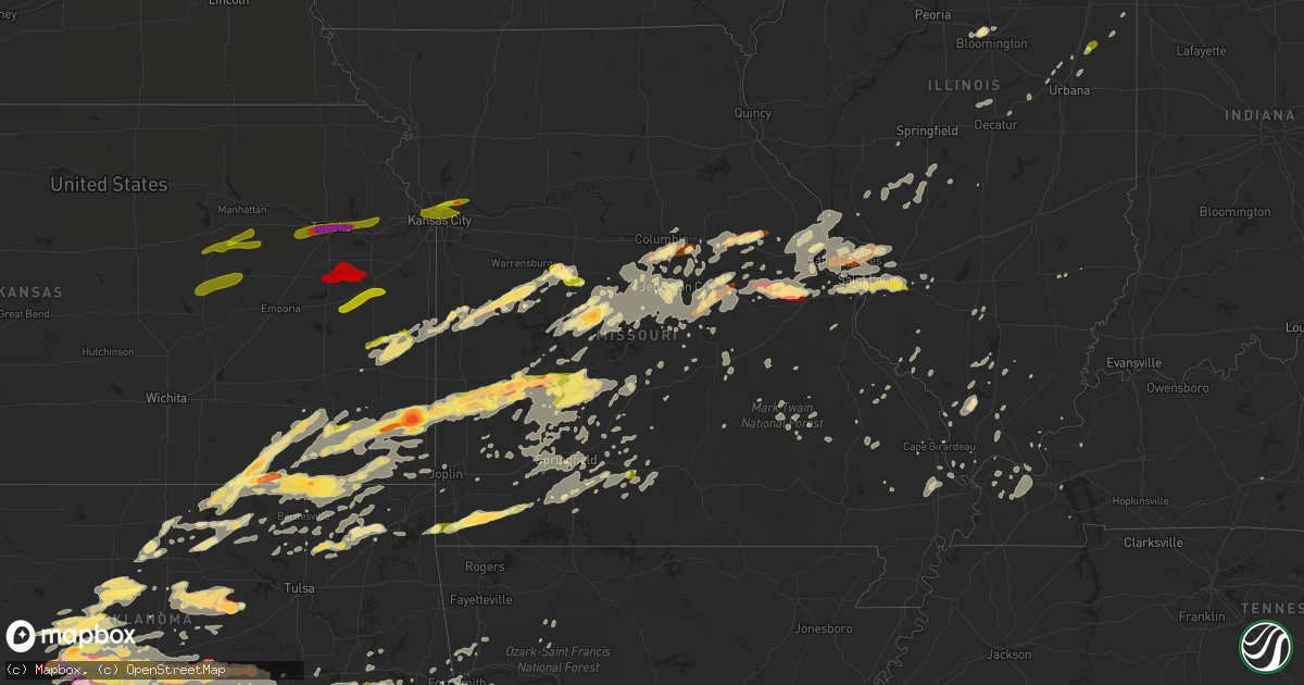
Hail Map in Missouri on May 31, 2013
Get this storm
May 31 map
$229
one time, instant access
Download today. No call, no setup
Keep the $229
Bought the map and want the full workflow? Apply the entire $229 to a subscription within 7 days. None of it is wasted.
Every map, not just this one
This buys you this map. Subscription and you get every map we run, in the markets you choose from a few cities to whole states to nationwide. Plus real-time alerts the moment a storm fires.
Contact data
Name, contact info, occupancy, even credit band for addresses in the footprint. You go from where it hit to who to call.
Become the source they trust
Unlimited branding weather history reports on demand. You already have the documented answer ready for the property owner, and you are the one who showed up with it.
Property data and RoofTrace estimates
Pull up any address you have got, its value and the exact code rules for that jurisdiction, straight from One Click Code. Then RoofTrace estimates the squares, pitch, and roof value, priced the way you price.
Storm reports in Missouri
Missouri
| Date | Description |
|---|---|
| 05/31/20136:38 PM CDT | A local report indicates 1.00 inch wind near LINN |
| 05/31/20136:30 PM CDT | Tornado reported 2 miles west of belleflower reported by missouri highway patrol |
| 05/31/20136:30 PM CDT | Montgomery city police reported a tornado just northeast of montgomery city |
| 05/31/20136:30 PM CDT | Delayed report via facebook picture of a tree fallen on a house with roof damage. Time was estimated by radar. |
| 05/31/20136:15 PM CDT | Tornado spotted near mineola heading towards new florence |
| 05/31/20135:46 PM CDT | A local report indicates 1.75 inch wind near 10 SSW STOVER |
| 05/31/20135:36 PM CDT | A local report indicates 1.25 inch wind near 10 W FULTON |
| 05/31/20135:35 PM CDT | Large tornado observed...partially rain wrapped |
| 05/31/20135:26 PM CDT | A local report indicates 1.00 inch wind near 5 S COLUMBIA |
| 05/31/20134:53 PM CDT | 4 to 6 inch limbs down. |
| 05/31/20134:25 PM CDT | 55 to 60 mph winds estimated in sedalia with pea sized hail. |
| 05/31/20134:25 PM CDT | 2 foot diameter tree uprooted. |
| 05/31/20134:25 PM CDT | Lots of dime sized hail mixed in. |
| 05/31/20134:19 PM CDT | A local report indicates 1.00 inch wind near 4 W SEDALIA |
| 05/31/20133:35 PM CDT | Communications tower blown down. |
| 05/31/20139:00 AM CDT | Trees down blocking both lanes of highway 94 near wainright |
| 05/31/20138:58 AM CDT | A local report indicates 1.00 inch wind near JEFFERSON CITY |
| 05/31/20138:57 AM CDT | Sixteen inch diameter tree snapped. |
| 05/31/20138:54 AM CDT | Six to eight inch tree snapped in east side of jefferson city. |
| 05/31/20138:48 AM CDT | Winds estimated at 60 mph tore shingles off of a home. |
| 05/31/20138:22 AM CDT | Large trees blown down in california and just east of tipton |
| 05/31/20138:10 AM CDT | Trees down blocking highways c and e. |
| 05/31/20138:05 AM CDT | Delayed report time estimated...picture via facebook of quarter sized hail |
| 05/31/20137:35 AM CDT | Trees down. One tree fell on a garage. Time estimated from radar. |
| 05/31/20131:42 AM CDT | A tree was blown down. |
| 05/31/20131:37 AM CDT | Nickel to quarter hail |
| 05/31/20131:10 AM CDT | Two foot diameter tree blown down just east of farm road 1090 on farm road 2020. |
| 05/31/20131:00 AM CDT | Time estimated from radar. |
| 05/31/201312:46 AM CDT | A local report indicates 2.00 inch wind near 1 S ROCKY COMFORT |
| 05/30/201311:53 PM CDT | Large tornado observed...partially rain wrapped |
| 05/30/201311:20 PM CDT | Quarter hail |
| 05/30/20138:35 PM CDT | 12-15 inch diameter tree limbs blown down |
| 05/30/20138:30 PM CDT | Delayed report and time estimated by radar...tree fell across driveway |
| 05/30/20138:25 PM CDT | 30-40 mph winds with quarter-sized hail. |
| 05/30/20138:23 PM CDT | 3 inch diameter tree limbs down |
| 05/30/20138:22 PM CDT | A local report indicates 1.00 inch wind near MARYLAND HEIGHTS |
| 05/30/20138:20 PM CDT | Pea-sized hail and 45-60 mph winds. |
| 05/30/20138:20 PM CDT | Numerous 8 to 10 inch diameter tree limbs down...power lines down...near chambers and elizabeth roads |
| 05/30/20138:17 PM CDT | Power lines downed at 170 and airport road |
| 05/30/20138:15 PM CDT | 18 wheeler reported to be on its side...at st charles rock road and hwy 270. Time estimated from radar. |
| 05/30/20138:15 PM CDT | Numerous 8-10 inch diameter tree limbs blown down...along with a 70 foot tall oak tree uprooted. |
| 05/30/20138:15 PM CDT | 3 foot diameter tree snapped....lots of 10 inch diameter limbs down...and multiple street signs down near st charles rock road and hwy 270. Time estimated from radar. |
| 05/30/20138:14 PM CDT | 34 inch tree down |
| 05/30/20138:14 PM CDT | Large tree limbs 8 to 10 inches in diameter snapped out of trees...near st charles rock road and geraldine |
| 05/30/20138:10 PM CDT | Delayed report time estimated...picture via facebook |
| 05/30/20138:10 PM CDT | A local report indicates 65 MPH wind near CHESTERFIELD |
| 05/30/20138:10 PM CDT | Roof damage reported...possible tornado |
| 05/30/20138:10 PM CDT | Tree limbs broken and blown down...damage to garage door and siding |
| 05/30/20138:10 PM CDT | Widespread nickle to quarter hail across southern hickory county. |
| 05/30/20138:10 PM CDT | 3-4 out buildings at lambert field destroyed |
| 05/30/20138:10 PM CDT | Uncpecified damage to the hollywood casino |
| 05/30/20138:08 PM CDT | On upper bottom court off upper bottom drive near the 364 bridge sw of st. Charles...there were large tree limbs down with one limb damaging a car port. |
| 05/30/20138:08 PM CDT | Large tree limbs blown down |
| 05/30/20138:06 PM CDT | A tree was reported down across highway aa just north of highway 32 blocking both lanes of traffic. Report time estimated by radar. |
| 05/30/20138:05 PM CDT | Roof removed at hollywood casino |
| 05/30/20138:05 PM CDT | Damage to fire station on jung station road south of highway 94...1 unjury possible...many trees blown down. |
| 05/30/20138:05 PM CDT | Tornado passed through 1.5 miles west of the intersection of towers road and caukshiill road.. There are numerous trees down roof damage to several homes in this area. |
| 05/30/20138:05 PM CDT | 6 inch diameter tree limbs blown down |
| 05/30/20138:02 PM CDT | Tree damage in the reddington oaks subdivision. Six inch diameter tree snapped cleanly 2 feet above the ground. Camper lifted over parked car and pushed into a house. P |
| 05/30/20138:01 PM CDT | Homes damaged at the whitmore country club golf course and subdivsion...at least one home lost a part of its roof |
| 05/30/20138:00 PM CDT | Trees blown down along with shingles and siding |
| 05/30/20138:00 PM CDT | A local report indicates 62 MPH wind near WELDON SPRING |
| 05/30/20137:58 PM CDT | A local report indicates 62 MPH wind near 3 W CHESTERFIELD |
| 05/30/20137:55 PM CDT | Tornado appears to damage structure in the missouri research park. |
| 05/30/20137:50 PM CDT | Trees blown down....car damaged due to tree falling on it at the daniel boone home |
| 05/30/20137:50 PM CDT | Many 8 inch plus limbs down...garage door blown in...power lines down over caulks hill rd |
| 05/30/20137:49 PM CDT | 1.0 to 1.5 inch diameter hail on the east side of washington. |
| 05/30/20137:38 PM CDT | Trees down |
| 05/30/20137:17 PM CDT | A local report indicates 60 MPH wind near TROY |
| 05/30/20137:15 PM CDT | A local report indicates 2.50 inch wind near CAPLINGER MILLS |
| 05/30/20137:15 PM CDT | Reported via photo through media. |
| 05/30/20137:00 PM CDT | A local report indicates 1.00 inch wind near PERSHING |
| 05/30/20137:00 PM CDT | Power lines blown down |
All States Impacted by Hail Map on May 31, 2013
Cities Impacted by Hail Map on May 31, 2013
- Marshfield, MO
- Webster City, IA
- Blairsburg, IA
- Jewell, IA
- Stanhope, IA
- Kamrar, IA
- Fredericktown, MO
- Goreville, IL
- Kellogg, MN
- Plainview, MN
- Arcola, MO
- Dadeville, MO
- Greenfield, MO
- Cole Camp, MO
- Glenwood City, WI
- Minco, OK
- Longton, KS
- Elk Falls, KS
- Sedan, KS
- Shidler, OK
- Cedar Vale, KS
- Moline, KS
- Saint Paul, MN
- Springfield, MO
- Morrisville, MO
- Willard, MO
- Holdenville, OK
- Seymour, IL
- Mahomet, IL
- Stigler, OK
- Wewoka, OK
- Carney, OK
- Circle Pines, MN
- Bloomer, WI
- Cornell, WI
- Humansville, MO
- Montgomery City, MO
- New Haven, MO
- Washington, MO
- Labadie, MO
- Whitehall, WI
- Konawa, OK
- Sasakwa, OK
- Newalla, OK
- Purcell, OK
- Washington, OK
- Bethany, OK
- Norman, OK
- Wanette, OK
- Blanchard, OK
- Hinton, OK
- Okarche, OK
- Mcloud, OK
- Meeker, OK
- Tuttle, OK
- Prague, OK
- El Reno, OK
- Boley, OK
- Mustang, OK
- Union City, OK
- Macomb, OK
- Noble, OK
- Wheatland, OK
- Yukon, OK
- Asher, OK
- Maud, OK
- Lexington, OK
- Shawnee, OK
- Byars, OK
- Spencer, OK
- Tecumseh, OK
- Harrah, OK
- Okemah, OK
- Oklahoma City, OK
- Newcastle, OK
- Lookeba, OK
- Choctaw, OK
- Calumet, OK
- Geary, OK
- Paden, OK
- Ralston, OK
- Altura, MN
- Chelsea, OK
- Stewartville, MN
- Chatfield, MN
- Rochester, MN
- Eyota, MN
- Jefferson City, MO
- Faxon, OK
- Lawton, OK
- Edwards, MO
- Versailles, MO
- Stover, MO
- Warsaw, MO
- Lincoln, MO
- Saint Louis, MO
- Hampton, KY
- Northwood, IA
- Kensett, IA
- Joice, IA
- Kevil, KY
- Geronimo, OK
- Grove, OK
- South West City, MO
- Wyandotte, OK
- Anderson, MO
- Barnett, MO
- Gravois Mills, MO
- Elgin, MN
- Wentzville, MO
- O'Fallon, MO
- Colfax, WI
- Lebanon, MO
- Wheaton, MO
- Goodman, MO
- Rocky Comfort, MO
- Exeter, MO
- Purdy, MO
- Stella, MO
- Fairview, MO
- Cassville, MO
- Butterfield, MO
- Adrian, MO
- Bison, OK
- Eufaula, OK
- Mcalester, OK
- Hanna, OK
- Quinton, OK
- Lamar, OK
- Indianola, OK
- Dustin, OK
- Henryetta, OK
- Weleetka, OK
- Canadian, OK
- Atwood, OK
- Crowder, OK
- Stuart, OK
- Calvin, OK
- Meta, MO
- Baldwin, WI
- Beldenville, WI
- River Falls, WI
- Woodville, WI
- Spring Valley, WI
- Humbird, WI
- Gillespie, IL
- Carlinville, IL
- Wheatland, MO
- Walnut, KS
- Farlington, KS
- Stockton, MO
- Thayer, KS
- Jerico Springs, MO
- Collins, MO
- Mulberry, KS
- Weaubleau, MO
- Girard, KS
- Lamar, MO
- Cherryvale, KS
- Arcadia, KS
- McCune, KS
- Milo, MO
- Parsons, KS
- Liberal, MO
- Dennis, KS
- Saint Paul, KS
- El Dorado Springs, MO
- Flemington, MO
- Pittsburg, KS
- Erie, KS
- Sheldon, MO
- Arma, KS
- Galesburg, KS
- Franklin, KS
- Mindenmines, MO
- Bronaugh, MO
- Poplar, WI
- Solon Springs, WI
- Lake Nebagamon, WI
- Gordon, WI
- Minong, WI
- Barronett, WI
- Brule, WI
- Elk City, KS
- Richview, IL
- Woodlawn, IL
- Ashley, IL
- Nelson, WI
- Wabasha, MN
- Lake City, MN
- Reads Landing, MN
- Walnut Shade, MO
- Ponca City, OK
- Marland, OK
- Clear Lake, WI
- Marlow, OK
- Rush Springs, OK
- Oakland, KY
- Holts Summit, MO
- Lohman, MO
- Russellville, MO
- Normal, IL
- Bloomington, IL
- Saint Charles, MO
- Windsor, MO
- Green Ridge, MO
- Minnesota City, MN
- Rollingstone, MN
- Walters, OK
- Stillwater, OK
- Cushing, OK
- Ripley, OK
- Perkins, OK
- Vinita, OK
- Hunter, OK
- Garber, OK
- Billings, OK
- Tonkawa, OK
- Moscow Mills, MO
- Troy, MO
- Winfield, MO
- Butler, MO
- Bolivar, MO
- Earlsboro, OK
- Hydro, OK
- Pocasset, OK
- Anadarko, OK
- Jones, OK
- Binger, OK
- Dover, MN
- California, MO
- Hettick, IL
- Palmyra, IL
- Girard, IL
- Chesterfield, IL
- Greenfield, IL
- Morrison, MO
- Chilhowee, MO
- Calhoun, MO
- Clinton, MO
- Blairstown, MO
- Leeton, MO
- Urich, MO
- Elmwood, WI
- Frederic, WI
- Grantsburg, WI
- Florence, WI
- Crystal Falls, MI
- Rogersville, MO
- Fordland, MO
- Seymour, MO
- Nowata, OK
- Talala, OK
- Plymouth, IA
- Mason City, IA
- Rock Falls, IA
- Nora Springs, IA
- Clayton, WI
- Dover, OK
- Kingfisher, OK
- Marshall, OK
- Loyal, OK
- Omega, OK
- Crescent, OK
- Watonga, OK
- Hennessey, OK
- Waukomis, OK
- Douglas, OK
- Greenfield, OK
- Billings, MO
- Mondovi, WI
- Thomasboro, IL
- Gifford, IL
- Rantoul, IL
- Urbana, IL
- Ballwin, MO
- Wildwood, MO
- Chesterfield, MO
- Fortuna, MO
- Dewey, IL
- Fisher, IL
- Eads, TN
- Dixon, MO
- Newburg, MO
- Fall Creek, WI
- Augusta, WI
- Shell Lake, WI
- Sarona, WI
- Duncan, OK
- Centerville, KS
- Rhinelander, WI
- Fletcher, OK
- Michigamme, MI
- Champion, MI
- Republic, MI
- Ashland, MO
- Columbia, MO
- Windyville, MO
- Urbana, MO
- Louisburg, MO
- Buffalo, MO
- Hermitage, MO
- Tunas, MO
- Eldridge, MO
- Havana, KS
- Dewey, OK
- Altamont, KS
- Long Lane, MO
- Everton, MO
- Edna, KS
- Fair Play, MO
- Polk, MO
- Newkirk, OK
- Moundville, MO
- Neodesha, KS
- Aurora, MO
- Caney, KS
- S Coffeyville, OK
- Tyro, KS
- Maple City, KS
- Mound Valley, KS
- Columbus, KS
- Wann, OK
- Coffeyville, KS
- Mount Vernon, MO
- Welch, OK
- Delaware, OK
- Independence, KS
- Brookline, MO
- Walnut Grove, MO
- Preston, MO
- Bartlett, KS
- Pittsburg, MO
- Half Way, MO
- Pawhuska, OK
- Frontenac, KS
- Ash Grove, MO
- Brighton, MO
- Osceola, MO
- Kaw City, OK
- Strafford, MO
- Dunnegan, MO
- Oswego, KS
- Peru, KS
- Pleasant Hope, MO
- Lenapah, OK
- Republic, MO
- Dexter, KS
- Lockwood, MO
- Altoona, KS
- Chautauqua, KS
- Fredonia, KS
- Marionville, MO
- Copan, OK
- Bois D Arc, MO
- Niotaze, KS
- Miller, MO
- Aldrich, MO
- Burbank, OK
- Dearing, KS
- Chetopa, KS
- Benedict, KS
- Scammon, KS
- Weir, KS
- Cherokee, KS
- Nevada, MO
- La Center, KY
- Wickliffe, KY
- Jamestown, MO
- Golconda, IL
- Muldrow, OK
- Hawk Point, MO
- Warrenton, MO
- Ludlow, IL
- Roland, OK
- Ogema, WI
- Westboro, WI
- Withee, WI
- Medford, WI
- Seminole, OK
- Linn, MO
- Loose Creek, MO
- Gerald, MO
- Osage, IA
- Saint Ansgar, IA
- Manly, IA
- Grafton, IA
- Scott City, MO
- Benton, MO
- Menomonie, WI
- Elk Mound, WI
- Verona, MO
- Eau Claire, WI
- Milford, IL
- Lesterville, MO
- Ironton, MO
- Golden City, MO
- Salem, MO
- Coyle, OK
- Conway, MO
- Potosi, MO
- Eleva, WI
- Oologah, OK
- Hugo, MN
- Olean, MO
- Eldon, MO
- Eugene, MO
- Agra, OK
- Chandler, OK
- Stroud, OK
- Tryon, OK
- Pulaski, IL
- Cunningham, KY
- Paducah, KY
- Boaz, KY
- Melber, KY
- Hickory, KY
- West Frankfort, IL
- Durand, WI
- Osseo, WI
- Fairfax, OK
- Pawnee, OK
- Clarion, IA
- Rowan, IA
- Belmond, IA
- Millville, MN
- Alden, IA
- Dows, IA
- Arcadia, WI
- Independence, WI
- Morrisonville, IL
- Piedmont, OK
- Hampton, IA
- Wood River, IL
- East Alton, IL
- Hartford, IL
- Roxana, IL
- Alton, IL
- O'Fallon, IL
- Fairview Heights, IL
- Marthasville, MO
- Florissant, MO
- Jim Falls, WI
- Hartsburg, MO
- New Bloomfield, MO
- Hermann, MO
- Bland, MO
- Owensville, MO
- Fountain City, WI
- Strum, WI
- Perry, OK
- Checotah, OK
- Brinktown, MO
- Sedalia, MO
- Rochester, IN
- Kewanna, IN
- Pana, IL
- Tripoli, WI
- Merrill, WI
- Tomahawk, WI
- Ava, MO
- Steelville, MO
- Nilwood, IL
- Raymond, IL
- Waggoner, IL
- Litchfield, IL
- Sikeston, MO
- Wetumka, OK
- Ramona, OK
- Chattanooga, OK
- Cache, OK
- Kincaid, KS
- Carbondale, IL
- Makanda, IL
- Porum, OK
- North Branch, MN
- Stacy, MN
- Wheeler, WI
- Knapp, WI
- Downing, WI
- Wilson, WI
- Boyceville, WI
- New Florence, MO
- Bellflower, MO
- High Hill, MO
- Spooner, WI
- Chamois, MO
- Alexander, IA
- Sheffield, IA
- Latimer, IA
- Holcombe, WI
- Chippewa Falls, WI
- Bartlesville, OK
- Havana, AR
- Big Cabin, OK
- Bonnots Mill, MO
- Westphalia, MO
- Freeburg, MO
- La Monte, MO
- Ellis Grove, IL
- Cairo, IL
- Tamms, IL
- Marissa, IL
- Sparta, IL
- Hardin, IL
- Galena, MO
- Crane, MO
- La Harpe, KS
- Williamsburg, MO
- Blue Mound, KS
- Bronson, KS
- Moran, KS
- Mound City, KS
- Sallisaw, OK
- Blair, WI
- Hixton, WI
- Alma Center, WI
- Sayner, WI
- Bruce, WI
- Chetek, WI
- Weyerhaeuser, WI
- Britt, IA
- Arkansaw, WI
- Olive Branch, IL
- Thebes, IL
- Miller City, IL
- Noel, MO
- Climax Springs, MO
- Taopi, MN
- Le Roy, MN
- Kinta, OK
- Guthrie, OK
- Ironwood, MI
- Hurley, WI
- Villa Ridge, IL
- Maple, WI
- Steeleville, IL
- Chester, IL
- Walsh, IL
- Rocky Mount, MO
- Latham, MO
- Argenta, IL
- Oreana, IL
- Vienna, MO
- Wakefield, MI
- Fulton, MO
- Meservey, IA
- Chapin, IA
- Fertile, IA
- Clear Lake, IA
- East Saint Louis, IL
- Ozark, MO
- Highlandville, MO
- Ponce De Leon, MO
- Spokane, MO
- Carlock, IL
- Hudson, IL
- Danvers, IL
- Stoutland, MO
- Richland, MO
- Smithton, MO
- Hartshorne, OK
- Blanco, OK
- Yale, OK
- Olney, IL
- Grovespring, MO
- Niangua, MO
- Hartville, MO
- Wyoming, MN
- Drumright, OK
- Thornton, IA
- Ashland, WI
- Mora, MO
- Barnsdall, OK
- Centertown, MO
- Bunker, MO
- Black, MO
- Alma, WI
- Adams, MN
- Carpenter, IA
- Hanlontown, IA
- Stacyville, IA
- Fairchild, WI
- Rhineland, MO
- Charleston, MO
- Thomas, OK
- Lake Ozark, MO
- Old Monroe, MO
- Galatia, IL
- Rosebud, MO
- Villa Ridge, MO
- Augusta, MO
- Leslie, MO
- Saint Mary, MO
- Perryville, MO
- Maramec, OK
- Orlando, OK
- Glencoe, OK
- Fenton, MO
- Valley Park, MO
- Cochrane, WI
- Sarcoxie, MO
- Trego, WI
- Saint Thomas, MO
- Lebanon, IL
- Temple, OK
- Pomona, IL
- Mountainburg, AR
- Cushing, WI
- Saint Croix Falls, WI
- Danbury, WI
- Popejoy, IA
- Montrose, MO
- Foster, MO
- La Cygne, KS
- Amsterdam, MO
- Amoret, MO
- Mapleton, KS
- Knob Noster, MO
- Pleasanton, KS
- Colony, KS
- Welda, KS
- Ramsay, MI
- Bessemer, MI
- Thompsonville, IL
- Grand Portage, MN
- Marquand, MO
- Lake Saint Louis, MO
- Defiance, MO
- Vienna, IL
- Centerville, MO
- Redford, MO
- Sparta, MO
- Muskogee, OK
- Braggs, OK
- Red Rock, OK
- Luther, OK
- Ada, OK
- Amber, OK
- Wellston, OK
- Cashion, OK
- Edmond, OK
- Castle, OK
- Sparks, OK
- Warrensburg, IL
- Latham, IL
- Maroa, IL
- Maryland Heights, MO
- Oran, MO
- Eureka, MO
- Ochelata, OK
- Florence, MO
- Paxton, IL
- Rankin, IL
- Elkland, MO
- Cedarville, AR
- Natural Dam, AR
- Chester, AR
- Rudy, AR
- Wynona, OK
- Hoopeston, IL
- Wellington, IL
- Superior, WI
- Sheldon, WI
- Mansfield, MO
- Taylor, WI
- Baxter Springs, KS
- Fair Grove, MO
- Noble, IL
- Cape Girardeau, MO
- Hazelwood, MO
- Wister, OK
- Beaver, OK
- Covington, OK
- Center City, MN
- De Soto, IL
- Murphysboro, IL
- Tebbetts, MO
- Mokane, MO
- Winamac, IN
- West Paducah, KY
- Bruner, MO
- Galena, KS
- Turtle Lake, WI
- Norwood, MO
- Drury, MO
- Saint James, MO
- Skiatook, OK
- Belleville, IL
- Foristell, MO
- Oark, AR
- Germantown, IL
- Aviston, IL
- Trenton, IL
- Hallsville, MO
- Minneapolis, MN
- Mulkeytown, IL
- Royalton, IL
- West Alton, MO
- Cobden, IL
- Ontonagon, MI
- Hitchcock, OK
- Cross Timbers, MO
- Deer Park, WI
- Webster, WI
- Farmington, MO
- Claremore, OK
- Benton, IL
- Rolla, MO
- Breese, IL
- Gracemont, OK
- Belleview, MO
- Saint Elizabeth, MO
- Prentice, WI
- Cadott, WI
- Deer, AR
- Ponca, AR
- Quincy, MO
- Williams, IA
- Henley, MO
- Dexter, KY
- Rockbridge, IL
- Marion, KY
- Bardwell, KY
- Crocker, MO
- Christopher, IL
- Winslow, AR
- Eau Galle, WI
- Charleston, AR
- Lanagan, MO
- Highland, IL
- Greenville, MO
- Van Buren, AR
- Blackwell, OK
- Fairmont, OK
- Fort Smith, AR
- Pocola, OK
- Hackett, AR
- Lavaca, AR
- Spiro, OK
- Arkoma, OK
- Greenwood, AR
- Barling, AR
- Glenville, MN
- Lyle, MN
- Steedman, MO
- Jonesburg, MO
- Portland, MO
- Truxton, MO
- Martinsburg, MO
- Auxvasse, MO
- Kingdom City, MO
- Andover, MN
- Forest Lake, MN
- Alto Pass, IL
- South Roxana, IL
- Bridgeton, MO
- Golden Eagle, IL
- Portage Des Sioux, MO
- Afton, OK
- Jerseyville, IL
- Mount Sterling, MO
- Tipton, MO
- Prairie Home, MO
- Bunceton, MO
- Argyle, MO
- Koeltztown, MO
- Clarksburg, MO
- Des Arc, MO
- Annapolis, MO
- Mulhall, OK
- Logansport, IN
- Glenallen, MO
- New Auburn, WI
- Swaledale, IA
- Utica, MN
- Wykoff, MN
- Metropolis, IL
- Brookport, IL
- Mercer, WI
- Meridian, OK
- Boyd, WI
- Collinsville, OK
- Chanute, KS
- Laquey, MO
- Wolf Lake, IL
- Jonesboro, IL
- Dupo, IL
- High Ridge, MO
- Caseyville, IL
- Collinsville, IL
- Granite City, IL
- East Carondelet, IL
- Whitefield, OK
- Hepler, KS
- Keota, OK
- Elizabethtown, IL
- Bloomfield, MO
- Thorp, WI
- Lublin, WI
- Sainte Genevieve, MO
- Iola, KS
- Puxico, MO
- Bixby, MO
- Riverton, KS
- Jackson, MO
- Nixa, MO
- Oldfield, MO
- Clever, MO
- Lucerne, IN
- Royal Center, IN
- Hazelhurst, WI
- Batchtown, IL
- Wayne, OK
- Maysville, OK
- Gilbertsville, KY
- Springbrook, WI
- Warner, OK
- Racine, MN
- Grand Meadow, MN
- New Berlin, IL
- Red Oak, OK
- Pacific, MO
- Mountain Grove, MO
- Falcon, MO
- Phillips, WI
- Cumberland, WI
- Joplin, MO
- Seneca, MO
- Jasper, MO
- Belle, MO
- Ava, IL
- Campbell Hill, IL
- Carl Junction, MO
- Webb City, MO
- Hillsboro, MO
- Monticello, IL
- De Land, IL
- Herrin, IL
- Syracuse, MO
- Lindstrom, MN
- Chisago City, MN
- Foley, MO
- Berger, MO
- Elsberry, MO
- Edwardsville, IL
- Saint Peters, MO
- Union, MO
- Brussels, IL
- Saint Ann, MO
- Wright City, MO
- Bethalto, IL
- Gray Summit, MO
- Madison, IL
- Earth City, MO
- Fieldon, IL
- Cottage Hills, IL
- Godfrey, IL
- Rudd, IA
- Floyd, IA
- Rockford, IA
- Charles City, IA
- Pawnee, IL
- Farmersville, IL
- Virden, IL
- Star City, IN
- Rose Creek, MN
- Brownsdale, MN
- Austin, MN
- Monticello, IN
- Francesville, IN
- Monon, IN
- Ozone, AR
- Bluejacket, OK
- Glen Carbon, IL
- Maryville, IL
- Gilman, WI
- Clay City, IL
- Saint Charles, MN
- Creal Springs, IL
- Altoona, WI
- Princeton, KS
- Ottawa, KS
- Rantoul, KS
- Waverly, KS
- Williamsburg, KS
- Scranton, KS
- Vassar, KS
- Osage City, KS
- Lyndon, KS
- Overbrook, KS
- Pomona, KS
- Quenemo, KS
- Weatherford, OK
- Scott Air Force Base, IL
- Lecompton, KS
- Oskaloosa, KS
- Tonganoxie, KS
- Grantville, KS
- Maple Hill, KS
- McLouth, KS
- Lawrence, KS
- Tecumseh, KS
- Perry, KS
- Topeka, KS
- Garnett, KS
- Liberty, MO
- Kansas City, MO
- Missouri City, MO
- Excelsior Springs, MO
- Independence, MO
- Kansas City, KS
- Riverside, MO
- Woodbine, KS
- Junction City, KS
- Alma, KS
- Alta Vista, KS
- Dwight, KS
- White City, KS
- Council Grove, KS
- Herington, KS
- Wilsey, KS
- Lincolnville, KS
- Lost Springs, KS
- Burdick, KS
- Lake Tomahawk, WI
- Woodruff, WI
- Minocqua, WI


