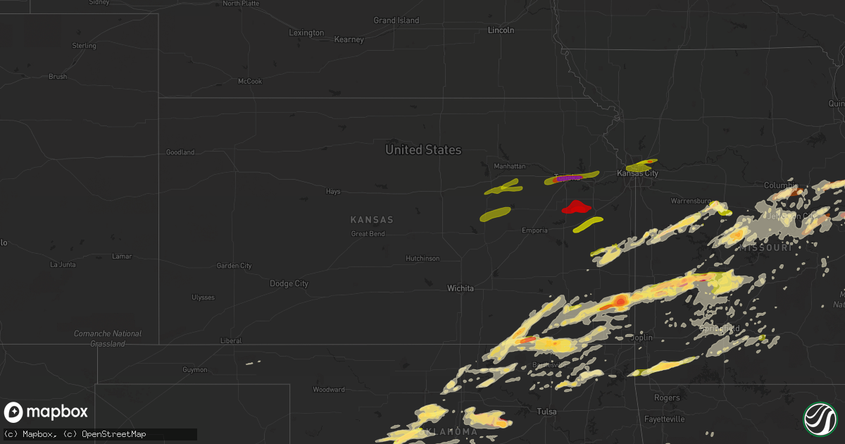
Hail Map in Kansas on May 31, 2013
Get this storm
May 31 map
$229
one time, instant access
Download today. No call, no setup
Keep the $229
Bought the map and want the full workflow? Apply the entire $229 to a subscription within 7 days. None of it is wasted.
Every map, not just this one
This buys you this map. Subscription and you get every map we run, in the markets you choose from a few cities to whole states to nationwide. Plus real-time alerts the moment a storm fires.
Contact data
Name, contact info, occupancy, even credit band for addresses in the footprint. You go from where it hit to who to call.
Become the source they trust
Unlimited branding weather history reports on demand. You already have the documented answer ready for the property owner, and you are the one who showed up with it.
Property data and RoofTrace estimates
Pull up any address you have got, its value and the exact code rules for that jurisdiction, straight from One Click Code. Then RoofTrace estimates the squares, pitch, and roof value, priced the way you price.
Storm reports in Kansas
Kansas
| Date | Description |
|---|---|
| 05/31/20136:30 PM CDT | A local report indicates 1.75 inch wind near CANEY |
| 05/31/20136:10 PM CDT | A local report indicates 2.50 inch wind near 2 S GIRARD |
| 05/31/20135:57 PM CDT | A local report indicates 1.00 inch wind near GIRARD |
| 05/31/20135:54 PM CDT | Delayed report...nickel hail also reported. |
| 05/31/20135:28 PM CDT | A local report indicates 1.00 inch wind near THAYER |
| 05/31/20135:11 PM CDT | Delayed report. Thunderstorm winds blew off a roof to a small outbuilding that landed across the road. Small tree limbs were also broken. Time is estimated from radar. |
| 05/31/20134:18 PM CDT | Brief touchdown. |
| 05/31/20133:37 PM CDT | Blew a car off of the road. |
| 05/30/20138:40 PM CDT | Pea sized hail also reported. |
| 05/30/20138:05 PM CDT | Estimated 85 mph winds caused a swath of damage from cedar vale to 9 miles nnw of sedan. Numerous trees...power lines and limbs reported down along this swath described |
| 05/30/20138:00 PM CDT | Tree limbs of 12 inches snapped |
| 05/30/20137:58 PM CDT | Wind damage to structures has been reported. |
| 05/30/20137:45 PM CDT | Delayed report via facebook picture from public |
| 05/30/20137:38 PM CDT | A local report indicates 70 MPH wind near CEDAR VALE |
All States Impacted by Hail Map on May 31, 2013
Cities Impacted by Hail Map on May 31, 2013
- Marshfield, MO
- Webster City, IA
- Blairsburg, IA
- Jewell, IA
- Stanhope, IA
- Kamrar, IA
- Fredericktown, MO
- Goreville, IL
- Kellogg, MN
- Plainview, MN
- Arcola, MO
- Dadeville, MO
- Greenfield, MO
- Cole Camp, MO
- Glenwood City, WI
- Minco, OK
- Longton, KS
- Elk Falls, KS
- Sedan, KS
- Shidler, OK
- Cedar Vale, KS
- Moline, KS
- Saint Paul, MN
- Springfield, MO
- Morrisville, MO
- Willard, MO
- Holdenville, OK
- Seymour, IL
- Mahomet, IL
- Stigler, OK
- Wewoka, OK
- Carney, OK
- Circle Pines, MN
- Bloomer, WI
- Cornell, WI
- Humansville, MO
- Montgomery City, MO
- New Haven, MO
- Washington, MO
- Labadie, MO
- Whitehall, WI
- Konawa, OK
- Sasakwa, OK
- Newalla, OK
- Purcell, OK
- Washington, OK
- Bethany, OK
- Norman, OK
- Wanette, OK
- Blanchard, OK
- Hinton, OK
- Okarche, OK
- Mcloud, OK
- Meeker, OK
- Tuttle, OK
- Prague, OK
- El Reno, OK
- Boley, OK
- Mustang, OK
- Union City, OK
- Macomb, OK
- Noble, OK
- Wheatland, OK
- Yukon, OK
- Asher, OK
- Maud, OK
- Lexington, OK
- Shawnee, OK
- Byars, OK
- Spencer, OK
- Tecumseh, OK
- Harrah, OK
- Okemah, OK
- Oklahoma City, OK
- Newcastle, OK
- Lookeba, OK
- Choctaw, OK
- Calumet, OK
- Geary, OK
- Paden, OK
- Ralston, OK
- Altura, MN
- Chelsea, OK
- Stewartville, MN
- Chatfield, MN
- Rochester, MN
- Eyota, MN
- Jefferson City, MO
- Faxon, OK
- Lawton, OK
- Edwards, MO
- Versailles, MO
- Stover, MO
- Warsaw, MO
- Lincoln, MO
- Saint Louis, MO
- Hampton, KY
- Northwood, IA
- Kensett, IA
- Joice, IA
- Kevil, KY
- Geronimo, OK
- Grove, OK
- South West City, MO
- Wyandotte, OK
- Anderson, MO
- Barnett, MO
- Gravois Mills, MO
- Elgin, MN
- Wentzville, MO
- O'Fallon, MO
- Colfax, WI
- Lebanon, MO
- Wheaton, MO
- Goodman, MO
- Rocky Comfort, MO
- Exeter, MO
- Purdy, MO
- Stella, MO
- Fairview, MO
- Cassville, MO
- Butterfield, MO
- Adrian, MO
- Bison, OK
- Eufaula, OK
- Mcalester, OK
- Hanna, OK
- Quinton, OK
- Lamar, OK
- Indianola, OK
- Dustin, OK
- Henryetta, OK
- Weleetka, OK
- Canadian, OK
- Atwood, OK
- Crowder, OK
- Stuart, OK
- Calvin, OK
- Meta, MO
- Baldwin, WI
- Beldenville, WI
- River Falls, WI
- Woodville, WI
- Spring Valley, WI
- Humbird, WI
- Gillespie, IL
- Carlinville, IL
- Wheatland, MO
- Walnut, KS
- Farlington, KS
- Stockton, MO
- Thayer, KS
- Jerico Springs, MO
- Collins, MO
- Mulberry, KS
- Weaubleau, MO
- Girard, KS
- Lamar, MO
- Cherryvale, KS
- Arcadia, KS
- McCune, KS
- Milo, MO
- Parsons, KS
- Liberal, MO
- Dennis, KS
- Saint Paul, KS
- El Dorado Springs, MO
- Flemington, MO
- Pittsburg, KS
- Erie, KS
- Sheldon, MO
- Arma, KS
- Galesburg, KS
- Franklin, KS
- Mindenmines, MO
- Bronaugh, MO
- Poplar, WI
- Solon Springs, WI
- Lake Nebagamon, WI
- Gordon, WI
- Minong, WI
- Barronett, WI
- Brule, WI
- Elk City, KS
- Richview, IL
- Woodlawn, IL
- Ashley, IL
- Nelson, WI
- Wabasha, MN
- Lake City, MN
- Reads Landing, MN
- Walnut Shade, MO
- Ponca City, OK
- Marland, OK
- Clear Lake, WI
- Marlow, OK
- Rush Springs, OK
- Oakland, KY
- Holts Summit, MO
- Lohman, MO
- Russellville, MO
- Normal, IL
- Bloomington, IL
- Saint Charles, MO
- Windsor, MO
- Green Ridge, MO
- Minnesota City, MN
- Rollingstone, MN
- Walters, OK
- Stillwater, OK
- Cushing, OK
- Ripley, OK
- Perkins, OK
- Vinita, OK
- Hunter, OK
- Garber, OK
- Billings, OK
- Tonkawa, OK
- Moscow Mills, MO
- Troy, MO
- Winfield, MO
- Butler, MO
- Bolivar, MO
- Earlsboro, OK
- Hydro, OK
- Pocasset, OK
- Anadarko, OK
- Jones, OK
- Binger, OK
- Dover, MN
- California, MO
- Hettick, IL
- Palmyra, IL
- Girard, IL
- Chesterfield, IL
- Greenfield, IL
- Morrison, MO
- Chilhowee, MO
- Calhoun, MO
- Clinton, MO
- Blairstown, MO
- Leeton, MO
- Urich, MO
- Elmwood, WI
- Frederic, WI
- Grantsburg, WI
- Florence, WI
- Crystal Falls, MI
- Rogersville, MO
- Fordland, MO
- Seymour, MO
- Nowata, OK
- Talala, OK
- Plymouth, IA
- Mason City, IA
- Rock Falls, IA
- Nora Springs, IA
- Clayton, WI
- Dover, OK
- Kingfisher, OK
- Marshall, OK
- Loyal, OK
- Omega, OK
- Crescent, OK
- Watonga, OK
- Hennessey, OK
- Waukomis, OK
- Douglas, OK
- Greenfield, OK
- Billings, MO
- Mondovi, WI
- Thomasboro, IL
- Gifford, IL
- Rantoul, IL
- Urbana, IL
- Ballwin, MO
- Wildwood, MO
- Chesterfield, MO
- Fortuna, MO
- Dewey, IL
- Fisher, IL
- Eads, TN
- Dixon, MO
- Newburg, MO
- Fall Creek, WI
- Augusta, WI
- Shell Lake, WI
- Sarona, WI
- Duncan, OK
- Centerville, KS
- Rhinelander, WI
- Fletcher, OK
- Michigamme, MI
- Champion, MI
- Republic, MI
- Ashland, MO
- Columbia, MO
- Windyville, MO
- Urbana, MO
- Louisburg, MO
- Buffalo, MO
- Hermitage, MO
- Tunas, MO
- Eldridge, MO
- Havana, KS
- Dewey, OK
- Altamont, KS
- Long Lane, MO
- Everton, MO
- Edna, KS
- Fair Play, MO
- Polk, MO
- Newkirk, OK
- Moundville, MO
- Neodesha, KS
- Aurora, MO
- Caney, KS
- S Coffeyville, OK
- Tyro, KS
- Maple City, KS
- Mound Valley, KS
- Columbus, KS
- Wann, OK
- Coffeyville, KS
- Mount Vernon, MO
- Welch, OK
- Delaware, OK
- Independence, KS
- Brookline, MO
- Walnut Grove, MO
- Preston, MO
- Bartlett, KS
- Pittsburg, MO
- Half Way, MO
- Pawhuska, OK
- Frontenac, KS
- Ash Grove, MO
- Brighton, MO
- Osceola, MO
- Kaw City, OK
- Strafford, MO
- Dunnegan, MO
- Oswego, KS
- Peru, KS
- Pleasant Hope, MO
- Lenapah, OK
- Republic, MO
- Dexter, KS
- Lockwood, MO
- Altoona, KS
- Chautauqua, KS
- Fredonia, KS
- Marionville, MO
- Copan, OK
- Bois D Arc, MO
- Niotaze, KS
- Miller, MO
- Aldrich, MO
- Burbank, OK
- Dearing, KS
- Chetopa, KS
- Benedict, KS
- Scammon, KS
- Weir, KS
- Cherokee, KS
- Nevada, MO
- La Center, KY
- Wickliffe, KY
- Jamestown, MO
- Golconda, IL
- Muldrow, OK
- Hawk Point, MO
- Warrenton, MO
- Ludlow, IL
- Roland, OK
- Ogema, WI
- Westboro, WI
- Withee, WI
- Medford, WI
- Seminole, OK
- Linn, MO
- Loose Creek, MO
- Gerald, MO
- Osage, IA
- Saint Ansgar, IA
- Manly, IA
- Grafton, IA
- Scott City, MO
- Benton, MO
- Menomonie, WI
- Elk Mound, WI
- Verona, MO
- Eau Claire, WI
- Milford, IL
- Lesterville, MO
- Ironton, MO
- Golden City, MO
- Salem, MO
- Coyle, OK
- Conway, MO
- Potosi, MO
- Eleva, WI
- Oologah, OK
- Hugo, MN
- Olean, MO
- Eldon, MO
- Eugene, MO
- Agra, OK
- Chandler, OK
- Stroud, OK
- Tryon, OK
- Pulaski, IL
- Cunningham, KY
- Paducah, KY
- Boaz, KY
- Melber, KY
- Hickory, KY
- West Frankfort, IL
- Durand, WI
- Osseo, WI
- Fairfax, OK
- Pawnee, OK
- Clarion, IA
- Rowan, IA
- Belmond, IA
- Millville, MN
- Alden, IA
- Dows, IA
- Arcadia, WI
- Independence, WI
- Morrisonville, IL
- Piedmont, OK
- Hampton, IA
- Wood River, IL
- East Alton, IL
- Hartford, IL
- Roxana, IL
- Alton, IL
- O'Fallon, IL
- Fairview Heights, IL
- Marthasville, MO
- Florissant, MO
- Jim Falls, WI
- Hartsburg, MO
- New Bloomfield, MO
- Hermann, MO
- Bland, MO
- Owensville, MO
- Fountain City, WI
- Strum, WI
- Perry, OK
- Checotah, OK
- Brinktown, MO
- Sedalia, MO
- Rochester, IN
- Kewanna, IN
- Pana, IL
- Tripoli, WI
- Merrill, WI
- Tomahawk, WI
- Ava, MO
- Steelville, MO
- Nilwood, IL
- Raymond, IL
- Waggoner, IL
- Litchfield, IL
- Sikeston, MO
- Wetumka, OK
- Ramona, OK
- Chattanooga, OK
- Cache, OK
- Kincaid, KS
- Carbondale, IL
- Makanda, IL
- Porum, OK
- North Branch, MN
- Stacy, MN
- Wheeler, WI
- Knapp, WI
- Downing, WI
- Wilson, WI
- Boyceville, WI
- New Florence, MO
- Bellflower, MO
- High Hill, MO
- Spooner, WI
- Chamois, MO
- Alexander, IA
- Sheffield, IA
- Latimer, IA
- Holcombe, WI
- Chippewa Falls, WI
- Bartlesville, OK
- Havana, AR
- Big Cabin, OK
- Bonnots Mill, MO
- Westphalia, MO
- Freeburg, MO
- La Monte, MO
- Ellis Grove, IL
- Cairo, IL
- Tamms, IL
- Marissa, IL
- Sparta, IL
- Hardin, IL
- Galena, MO
- Crane, MO
- La Harpe, KS
- Williamsburg, MO
- Blue Mound, KS
- Bronson, KS
- Moran, KS
- Mound City, KS
- Sallisaw, OK
- Blair, WI
- Hixton, WI
- Alma Center, WI
- Sayner, WI
- Bruce, WI
- Chetek, WI
- Weyerhaeuser, WI
- Britt, IA
- Arkansaw, WI
- Olive Branch, IL
- Thebes, IL
- Miller City, IL
- Noel, MO
- Climax Springs, MO
- Taopi, MN
- Le Roy, MN
- Kinta, OK
- Guthrie, OK
- Ironwood, MI
- Hurley, WI
- Villa Ridge, IL
- Maple, WI
- Steeleville, IL
- Chester, IL
- Walsh, IL
- Rocky Mount, MO
- Latham, MO
- Argenta, IL
- Oreana, IL
- Vienna, MO
- Wakefield, MI
- Fulton, MO
- Meservey, IA
- Chapin, IA
- Fertile, IA
- Clear Lake, IA
- East Saint Louis, IL
- Ozark, MO
- Highlandville, MO
- Ponce De Leon, MO
- Spokane, MO
- Carlock, IL
- Hudson, IL
- Danvers, IL
- Stoutland, MO
- Richland, MO
- Smithton, MO
- Hartshorne, OK
- Blanco, OK
- Yale, OK
- Olney, IL
- Grovespring, MO
- Niangua, MO
- Hartville, MO
- Wyoming, MN
- Drumright, OK
- Thornton, IA
- Ashland, WI
- Mora, MO
- Barnsdall, OK
- Centertown, MO
- Bunker, MO
- Black, MO
- Alma, WI
- Adams, MN
- Carpenter, IA
- Hanlontown, IA
- Stacyville, IA
- Fairchild, WI
- Rhineland, MO
- Charleston, MO
- Thomas, OK
- Lake Ozark, MO
- Old Monroe, MO
- Galatia, IL
- Rosebud, MO
- Villa Ridge, MO
- Augusta, MO
- Leslie, MO
- Saint Mary, MO
- Perryville, MO
- Maramec, OK
- Orlando, OK
- Glencoe, OK
- Fenton, MO
- Valley Park, MO
- Cochrane, WI
- Sarcoxie, MO
- Trego, WI
- Saint Thomas, MO
- Lebanon, IL
- Temple, OK
- Pomona, IL
- Mountainburg, AR
- Cushing, WI
- Saint Croix Falls, WI
- Danbury, WI
- Popejoy, IA
- Montrose, MO
- Foster, MO
- La Cygne, KS
- Amsterdam, MO
- Amoret, MO
- Mapleton, KS
- Knob Noster, MO
- Pleasanton, KS
- Colony, KS
- Welda, KS
- Ramsay, MI
- Bessemer, MI
- Thompsonville, IL
- Grand Portage, MN
- Marquand, MO
- Lake Saint Louis, MO
- Defiance, MO
- Vienna, IL
- Centerville, MO
- Redford, MO
- Sparta, MO
- Muskogee, OK
- Braggs, OK
- Red Rock, OK
- Luther, OK
- Ada, OK
- Amber, OK
- Wellston, OK
- Cashion, OK
- Edmond, OK
- Castle, OK
- Sparks, OK
- Warrensburg, IL
- Latham, IL
- Maroa, IL
- Maryland Heights, MO
- Oran, MO
- Eureka, MO
- Ochelata, OK
- Florence, MO
- Paxton, IL
- Rankin, IL
- Elkland, MO
- Cedarville, AR
- Natural Dam, AR
- Chester, AR
- Rudy, AR
- Wynona, OK
- Hoopeston, IL
- Wellington, IL
- Superior, WI
- Sheldon, WI
- Mansfield, MO
- Taylor, WI
- Baxter Springs, KS
- Fair Grove, MO
- Noble, IL
- Cape Girardeau, MO
- Hazelwood, MO
- Wister, OK
- Beaver, OK
- Covington, OK
- Center City, MN
- De Soto, IL
- Murphysboro, IL
- Tebbetts, MO
- Mokane, MO
- Winamac, IN
- West Paducah, KY
- Bruner, MO
- Galena, KS
- Turtle Lake, WI
- Norwood, MO
- Drury, MO
- Saint James, MO
- Skiatook, OK
- Belleville, IL
- Foristell, MO
- Oark, AR
- Germantown, IL
- Aviston, IL
- Trenton, IL
- Hallsville, MO
- Minneapolis, MN
- Mulkeytown, IL
- Royalton, IL
- West Alton, MO
- Cobden, IL
- Ontonagon, MI
- Hitchcock, OK
- Cross Timbers, MO
- Deer Park, WI
- Webster, WI
- Farmington, MO
- Claremore, OK
- Benton, IL
- Rolla, MO
- Breese, IL
- Gracemont, OK
- Belleview, MO
- Saint Elizabeth, MO
- Prentice, WI
- Cadott, WI
- Deer, AR
- Ponca, AR
- Quincy, MO
- Williams, IA
- Henley, MO
- Dexter, KY
- Rockbridge, IL
- Marion, KY
- Bardwell, KY
- Crocker, MO
- Christopher, IL
- Winslow, AR
- Eau Galle, WI
- Charleston, AR
- Lanagan, MO
- Highland, IL
- Greenville, MO
- Van Buren, AR
- Blackwell, OK
- Fairmont, OK
- Fort Smith, AR
- Pocola, OK
- Hackett, AR
- Lavaca, AR
- Spiro, OK
- Arkoma, OK
- Greenwood, AR
- Barling, AR
- Glenville, MN
- Lyle, MN
- Steedman, MO
- Jonesburg, MO
- Portland, MO
- Truxton, MO
- Martinsburg, MO
- Auxvasse, MO
- Kingdom City, MO
- Andover, MN
- Forest Lake, MN
- Alto Pass, IL
- South Roxana, IL
- Bridgeton, MO
- Golden Eagle, IL
- Portage Des Sioux, MO
- Afton, OK
- Jerseyville, IL
- Mount Sterling, MO
- Tipton, MO
- Prairie Home, MO
- Bunceton, MO
- Argyle, MO
- Koeltztown, MO
- Clarksburg, MO
- Des Arc, MO
- Annapolis, MO
- Mulhall, OK
- Logansport, IN
- Glenallen, MO
- New Auburn, WI
- Swaledale, IA
- Utica, MN
- Wykoff, MN
- Metropolis, IL
- Brookport, IL
- Mercer, WI
- Meridian, OK
- Boyd, WI
- Collinsville, OK
- Chanute, KS
- Laquey, MO
- Wolf Lake, IL
- Jonesboro, IL
- Dupo, IL
- High Ridge, MO
- Caseyville, IL
- Collinsville, IL
- Granite City, IL
- East Carondelet, IL
- Whitefield, OK
- Hepler, KS
- Keota, OK
- Elizabethtown, IL
- Bloomfield, MO
- Thorp, WI
- Lublin, WI
- Sainte Genevieve, MO
- Iola, KS
- Puxico, MO
- Bixby, MO
- Riverton, KS
- Jackson, MO
- Nixa, MO
- Oldfield, MO
- Clever, MO
- Lucerne, IN
- Royal Center, IN
- Hazelhurst, WI
- Batchtown, IL
- Wayne, OK
- Maysville, OK
- Gilbertsville, KY
- Springbrook, WI
- Warner, OK
- Racine, MN
- Grand Meadow, MN
- New Berlin, IL
- Red Oak, OK
- Pacific, MO
- Mountain Grove, MO
- Falcon, MO
- Phillips, WI
- Cumberland, WI
- Joplin, MO
- Seneca, MO
- Jasper, MO
- Belle, MO
- Ava, IL
- Campbell Hill, IL
- Carl Junction, MO
- Webb City, MO
- Hillsboro, MO
- Monticello, IL
- De Land, IL
- Herrin, IL
- Syracuse, MO
- Lindstrom, MN
- Chisago City, MN
- Foley, MO
- Berger, MO
- Elsberry, MO
- Edwardsville, IL
- Saint Peters, MO
- Union, MO
- Brussels, IL
- Saint Ann, MO
- Wright City, MO
- Bethalto, IL
- Gray Summit, MO
- Madison, IL
- Earth City, MO
- Fieldon, IL
- Cottage Hills, IL
- Godfrey, IL
- Rudd, IA
- Floyd, IA
- Rockford, IA
- Charles City, IA
- Pawnee, IL
- Farmersville, IL
- Virden, IL
- Star City, IN
- Rose Creek, MN
- Brownsdale, MN
- Austin, MN
- Monticello, IN
- Francesville, IN
- Monon, IN
- Ozone, AR
- Bluejacket, OK
- Glen Carbon, IL
- Maryville, IL
- Gilman, WI
- Clay City, IL
- Saint Charles, MN
- Creal Springs, IL
- Altoona, WI
- Princeton, KS
- Ottawa, KS
- Rantoul, KS
- Waverly, KS
- Williamsburg, KS
- Scranton, KS
- Vassar, KS
- Osage City, KS
- Lyndon, KS
- Overbrook, KS
- Pomona, KS
- Quenemo, KS
- Weatherford, OK
- Scott Air Force Base, IL
- Lecompton, KS
- Oskaloosa, KS
- Tonganoxie, KS
- Grantville, KS
- Maple Hill, KS
- McLouth, KS
- Lawrence, KS
- Tecumseh, KS
- Perry, KS
- Topeka, KS
- Garnett, KS
- Liberty, MO
- Kansas City, MO
- Missouri City, MO
- Excelsior Springs, MO
- Independence, MO
- Kansas City, KS
- Riverside, MO
- Woodbine, KS
- Junction City, KS
- Alma, KS
- Alta Vista, KS
- Dwight, KS
- White City, KS
- Council Grove, KS
- Herington, KS
- Wilsey, KS
- Lincolnville, KS
- Lost Springs, KS
- Burdick, KS
- Lake Tomahawk, WI
- Woodruff, WI
- Minocqua, WI


