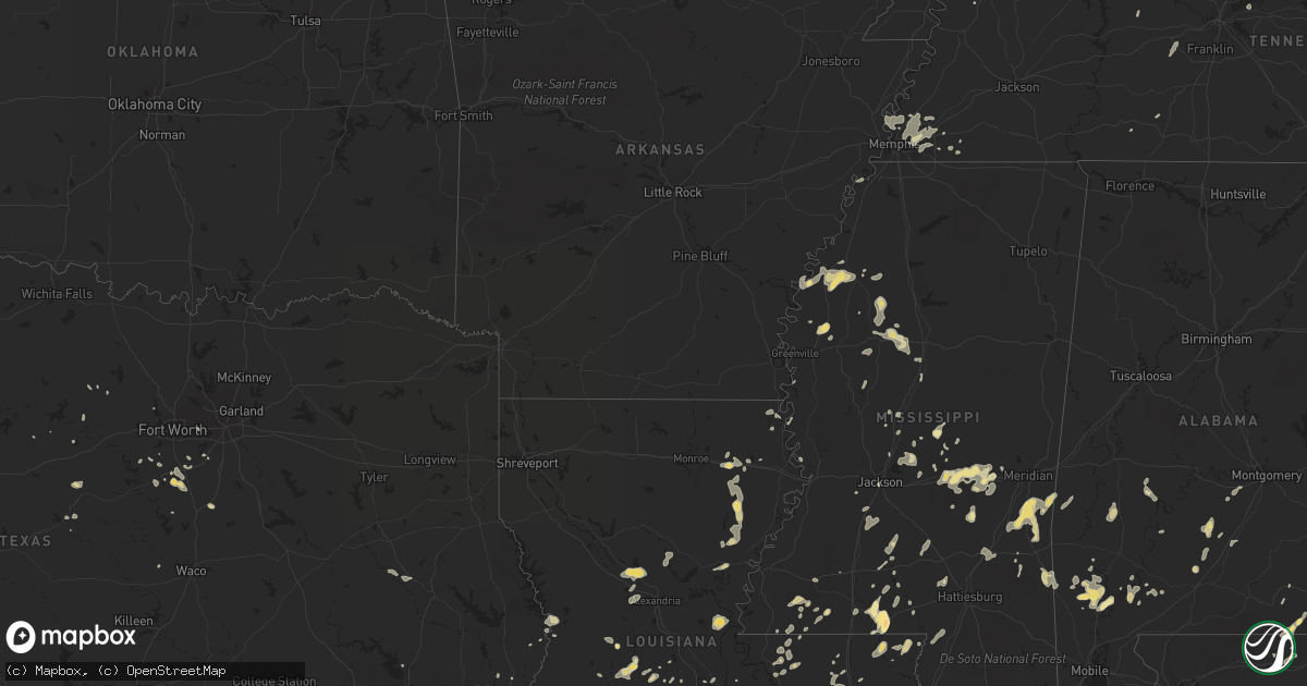
Hail Map in Kentucky on May 31, 2012
Get this storm
May 31 map
$229
one time, instant access
Download today. No call, no setup
Keep the $229
Bought the map and want the full workflow? Apply the entire $229 to a subscription within 7 days. None of it is wasted.
Every map, not just this one
This buys you this map. Subscription and you get every map we run, in the markets you choose from a few cities to whole states to nationwide. Plus real-time alerts the moment a storm fires.
Contact data
Name, contact info, occupancy, even credit band for addresses in the footprint. You go from where it hit to who to call.
Become the source they trust
Unlimited branding weather history reports on demand. You already have the documented answer ready for the property owner, and you are the one who showed up with it.
Property data and RoofTrace estimates
Pull up any address you have got, its value and the exact code rules for that jurisdiction, straight from One Click Code. Then RoofTrace estimates the squares, pitch, and roof value, priced the way you price.
Storm reports in Kentucky
Kentucky
| Date | Description |
|---|---|
| 05/31/20126:17 PM CDT | Half inch hail |
| 05/31/20125:42 PM CDT | Tree down across the western kentucky parkway near pea ridge road. |
| 05/31/20125:18 PM CDT | A local report indicates 1.00 inch wind near IRVINGTON |
| 05/31/20125:07 PM CDT | Six inch diameter branch snapped by thunderstorm winds. |
| 05/31/20125:03 PM CDT | Six inch diameter branch snapped by thunderstorm winds. |
| 05/31/20125:01 PM CDT | Between sample and union star. |
| 05/31/20124:44 PM CDT | Trees down with estimated wind gust 60 to 65 mph. Dime to marble size hail reported. |
| 05/31/20124:33 PM CDT | Emergency management reported three trees down across the county. One fell across midway lane in hawesville. |
All States Impacted by Hail Map on May 31, 2012
Cities Impacted by Hail Map on May 31, 2012
- Defuniak Springs, FL
- Oakdale, LA
- Oberlin, LA
- Mitchell, GA
- Boncarbo, CO
- Weston, CO
- Trinidad, CO
- Sontag, MS
- Monticello, MS
- Dahlonega, GA
- Delhi, LA
- Frisco City, AL
- Chatom, AL
- Sour Lake, TX
- Waynesboro, TN
- Troy, TN
- Obion, TN
- Brunswick, GA
- Hortense, GA
- Carthage, MS
- Elba, AL
- Green Cove Springs, FL
- Live Oak, FL
- Sicily Island, LA
- Milford, TX
- Mccomb, MS
- Jayess, MS
- Tylertown, MS
- Winnsboro, LA
- Gilbert, LA
- Sweet Water, AL
- Dixons Mills, AL
- Trementina, NM
- Clarkton, MO
- Gideon, MO
- Mount Juliet, TN
- Wellborn, FL
- McAlpin, FL
- Lake City, FL
- Horse Branch, KY
- Caneyville, KY
- Gibson, MO
- Campbell, MO
- Piggott, AR
- Portageville, MO
- Holcomb, MO
- Saint Francis, AR
- Lawrence, MS
- Conehatta, MS
- Hickory, MS
- Pulaski, MS
- Forest, MS
- Lake, MS
- Morton, MS
- Newton, MS
- Decatur, MS
- Lowndesboro, AL
- Hayneville, AL
- San Antonio, TX
- Centreville, MS
- Cleburne, TX
- Keene, TX
- Barney, GA
- Adel, GA
- Cleveland, GA
- Alpine, TX
- Cedar Hill, TN
- Springfield, TN
- Cloutierville, LA
- Colfax, LA
- Dry Prong, LA
- Fredonia, KY
- Saint Martinville, LA
- Fort Davis, TX
- Owensboro, KY
- Stephensport, KY
- Hawesville, KY
- Union Star, KY
- Lewisport, KY
- Maceo, KY
- Rockport, IN
- Hardinsburg, KY
- Cannelton, IN
- Webster, KY
- Shelby, MS
- Fitzgerald, GA
- Chrisney, IN
- Richland, IN
- Terry, MS
- Talbotton, GA
- Ferriday, LA
- Jonesville, LA
- Forest Home, AL
- Pine Apple, AL
- Greenville, AL
- Minter, AL
- Alto, TX
- Wells, TX
- Pollok, TX
- Mayfield, KY
- Wagarville, AL
- Sunflower, AL
- McIntosh, AL
- White Oak, GA
- Woodbine, GA
- Belzoni, MS
- Tchula, MS
- East Prairie, MO
- Samson, AL
- Geneva, AL
- Coffee Springs, AL
- Ponce De Leon, FL
- Searcy, AR
- Lyles, TN
- Bon Aqua, TN
- Fairview, TN
- Meridian, MS
- Vossburg, MS
- Shubuta, MS
- Pachuta, MS
- Waynesboro, MS
- Heidelberg, MS
- Lisman, AL
- Butler, AL
- Quitman, MS
- Moscow, TN
- Lafayette, LA
- Scott, LA
- Cordova, TN
- Collierville, TN
- Germantown, TN
- Eads, TN
- Thomasville, GA
- Boston, GA
- Coolidge, GA
- Pavo, GA
- Liberty, MS
- Osyka, MS
- Savannah, GA
- Wagon Mound, NM
- Ocate, NM
- Rosenberg, TX
- Ekron, KY
- Fort Stewart, GA
- Springer, NM
- Black Oak, AR
- Leesville, LA
- Deridder, LA
- Marion, KY
- Clay, KY
- Groveland, FL
- Laurel, MS
- Twin City, GA
- Swainsboro, GA
- Gloster, MS
- Crosby, MS
- Rayville, LA
- Slaughter, LA
- Zachary, LA
- Ethel, LA
- Clinton, LA
- Beaver Dam, KY
- Cromwell, KY
- Morgantown, KY
- Pitkin, LA
- Raton, NM
- Earle, AR
- Anacoco, LA
- Grapeland, TX
- Center Point, TX
- Alvarado, TX
- Venus, TX
- Dawson Springs, KY
- Crofton, KY
- Saint Charles, KY
- Tibbie, AL
- Leroy, AL
- Saint Stephens, AL
- State Line, MS
- Fruitdale, AL
- Millry, AL
- Buckatunna, MS
- Garita, NM
- Orange, TX
- La Vernia, TX
- Ludowici, GA
- Atmore, AL
- Saint Hedwig, TX
- Adkins, TX
- Rose Hill, MS
- Princeton, KY
- Cerulean, KY
- Burkeville, TX
- Uriah, AL
- Bay City, TX
- Port Wentworth, GA
- Ellabell, GA
- Bloomingdale, GA
- Pooler, GA
- Wingo, KY
- Clinton, KY
- Tallahassee, FL
- Moultrie, GA
- Hammond, LA
- Springfield, LA
- Holden, LA
- Drakesboro, KY
- Browder, KY
- Belton, KY
- Saint Augustine, FL
- Trout, LA
- Ellisville, MS
- Norwood, LA
- Wilson, LA
- Williston, TN
- Jackson, LA
- Jbsa Randolph, TX
- Cibolo, TX
- Universal City, TX
- Schertz, TX
- Philipp, MS
- Charleston, MS
- West Columbia, TX
- Sweeny, TX
- Fairdale, KY
- Shaw, MS
- Canton, MS
- El Campo, TX
- Palm Coast, FL
- Hastings, FL
- Evergreen, AL
- Irvington, KY
- Brandenburg, KY
- Guston, KY
- Clayton, LA
- Baskin, LA
- Faunsdale, AL
- Linden, AL
- Milledgeville, GA
- Grandview, TX
- Opelousas, LA
- Quitman, GA
- Morven, GA
- Geneva, FL
- Mims, FL
- Turrell, AR
- Greenwood, MS
- Carrollton, MS
- Coila, MS
- Indianola, MS
- Lake Providence, LA
- McRae Helena, GA
- Minter City, MS
- Clarksdale, MS
- Duncan, MS
- Tutwiler, MS
- Camden, AL
- Fancy Farm, KY
- Jackson, AL
- Memphis, TN
- Jacksonville, FL
- Warrenton, GA
- Alamo, GA
- Deer Park, AL
- Hahira, GA
- Berlin, GA
- Fisherville, KY
- Godley, TX
- Buna, TX
- Boerne, TX
- Bergheim, TX
- Gunnison, MS
- Catherine, AL
- Jacksboro, TX
- Stockdale, TX
- Drew, MS
- Valdosta, GA
- Duson, LA
- Fred, TX
- De Leon Springs, FL
- Maxwell, NM
- Tickfaw, LA
- Independence, LA
- Albany, LA
- Bunnell, FL
- Hollandale, MS
- Greenville, MS
- Crawford, TX
- Valley Mills, TX
- Palo Pinto, TX
- Gordon, TX
- Kirbyville, TX
- Madison, MS
- Bay Springs, MS
- Louin, MS
- Fleming Island, FL
- Orange Park, FL
- Marksville, LA
- Moreauville, LA
- Augusta, AR
- Sumrall, MS
- Garyville, LA
- Quincy, FL
- Pollock, LA
- Graford, TX
- Naylor, GA
- Lexa, AR
- West Helena, AR
- Stephenville, TX
- Gainestown, AL
- Gilmore, AR
- Crawfordsville, AR
- Krotz Springs, LA
- Westlake, LA
- Taylorsville, KY
- Allenhurst, GA
- Tell City, IN
- Troy, IN
- Millington, TN
- Arlington, TN
- Mound Bayou, MS
- Snow Lake, AR
- Alligator, MS
- Boyle, MS
- Perrin, TX
- Lena, MS
- Brandon, MS
- Silver Creek, MS
- Erath, LA
- Thomaston, GA
- Fordoche, LA
- Damon, TX
- Franklinton, LA
- Frankfort, KY
- Mamou, LA
- Livingston, LA
- Eunice, LA
- Galveston, TX
- Heth, AR
- Widener, AR
- West, MS
- Richmond, TX
- Jackson, MS
- Thomasville, AL
- Strawn, TX
- Oak Grove, LA
- Sturgis, KY
- Providence, KY
- Dixon, KY
- Raleigh, MS
- Macclenny, FL
- La Place, LA
- Crystal Springs, MS
- Balmorhea, TX
- New Orleans, LA
- Middleburg, FL
- Ville Platte, LA
- Maurice, LA
- Youngsville, LA
- Rayne, LA
- Elizabeth, IN
- Laconia, IN
- Walnut Grove, MS
- Rolling Fork, MS
- Ray City, GA
- Chunky, MS
- Schlater, MS
- Maurepas, LA
- Howey In The Hills, FL
- Louisville, KY
- Devers, TX
- Summertown, TN
- Lawrenceburg, TN
- Ethridge, TN
- Pierson, FL
- Astor, FL
- Cedar Hill, TX
- Grosse Tete, LA
- Owenton, KY
- Waddy, KY
- Shelbyville, KY
- Hughes, AR
- Hornbeak, TN
- Osteen, FL
- Boyce, LA
- Marion, TX
- Seguin, TX
- Blowing Rock, NC
- Boone, NC
- Kountze, TX
- Kaplan, LA
- Vaiden, MS
- Needville, TX
- Mount Olive, MS
- Prentiss, MS
- Magee, MS
- Kinston, AL
- Sanderson, FL
- Blum, TX
- Westville, FL
- Venice, LA
- Newton, TX
- Eagle Lake, TX
- Meadville, MS
- Bude, MS
- Starke, FL
- Sparta, GA
- Eatonton, GA
- Paulina, LA
- Saint James, LA
- Convent, LA
- Church Point, LA
- Buras, LA
- Conchas Dam, NM
- Chipley, FL
- Saint Amant, LA
- Gonzales, LA
- Pleasant View, TN
- Bluffton, GA
- Ochlocknee, GA
- Angie, LA
- Philpot, KY
- Dry Creek, LA
- Simpsonville, KY
- Finchville, KY
- Smithdale, MS
- Sunset, LA
- Cloverport, KY
- Derby, IN
- Payneville, KY
- Rome, IN
- Battletown, KY
- Mauckport, IN
- Corydon, IN
- Rhodelia, KY
- Harned, KY
- Benton, MS
- Pickens, MS
- Call, TX
- Bainbridge, GA
- Hahnville, LA
- Baton Rouge, LA
- Port Barre, LA
- Washington, LA
- Azle, TX
- Wharton, TX
- Greensburg, LA
- Amite, LA
- Seminary, MS
- Cairo, GA
- Tallulah, LA
- Vine Grove, KY
- Rineyville, KY
- Custer, KY
- Belle Chasse, LA
- Dublin, TX
- Marked Tree, AR
- Tyronza, AR
- Dequincy, LA
- Kokomo, MS
- Foxworth, MS
- Altha, FL
- Longwood, FL
- Oak Vale, MS
- Vicksburg, MS
- Mount Hermon, LA
- White Castle, LA
- Columbia, MS
- Benoit, MS
- Cleveland, MS
- McKenzie, AL
- Georgiana, AL
- Newhebron, MS
- Sycamore, GA
- Chula, GA
- Pelahatchie, MS
- Robinsonville, MS
- Brookhaven, MS
- Livingston, TX
- Junction City, GA
- Loranger, LA
- Granbury, TX
- Sidon, MS
- Itta Bena, MS
- Uniontown, AL
- Junction, TX
- Port Allen, LA
- Ormond Beach, FL
- Radcliff, KY
- Lena, LA
- Bentley, LA
- North Carrollton, MS
- Winona, MS
- Vaughan, MS
- Midlothian, TX
- Erin, TN
- Pinola, MS
- O'Brien, FL
- Harrisonburg, LA
- Meigs, GA
- Lafitte, LA
- Metter, GA
- Rossville, TN
- Butler, GA
- Vance, MS
- Thibodaux, LA
- Nortonville, KY
- Grand Ridge, FL
- Marianna, FL
- Ruth, MS
- Lumberton, MS
- Poplarville, MS
- Atoka, TN
- Sulphur, LA
- La Grange, TX
- Waverly, AL
- Dauphin Island, AL
- Bulverde, TX
- Saint Johns, FL
- Ponte Vedra, FL
- Florence, MS
- Harrisville, MS
- Oakland, TN
- Summit, MS
- Waverly, GA
- Eudora, AR
- Converse, TX
- Blairsville, GA
- Murrayville, GA
- Arlington, TX
- Mount Washington, KY
- Shepherdsville, KY
- Flagler Beach, FL
- Chancellor, AL
- Elmer, LA
- Alexandria, LA
- Ragley, LA
- Raymond, MS
- Jachin, AL
- Hardeeville, SC
- Crowley, TX
- Crestwood, KY
- Joshua, TX
- Abbeville, LA
- Caddo, TX
- Falls Of Rough, KY
- Alberta, AL


