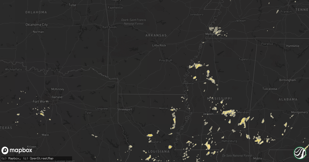
Hail Map in Georgia on May 31, 2012
Get this storm
May 31 map
$229
one time, instant access
Download today. No call, no setup
Keep the $229
Bought the map and want the full workflow? Apply the entire $229 to a subscription within 7 days. None of it is wasted.
Every map, not just this one
This buys you this map. Subscription and you get every map we run, in the markets you choose from a few cities to whole states to nationwide. Plus real-time alerts the moment a storm fires.
Contact data
Name, contact info, occupancy, even credit band for addresses in the footprint. You go from where it hit to who to call.
Become the source they trust
Unlimited branding weather history reports on demand. You already have the documented answer ready for the property owner, and you are the one who showed up with it.
Property data and RoofTrace estimates
Pull up any address you have got, its value and the exact code rules for that jurisdiction, straight from One Click Code. Then RoofTrace estimates the squares, pitch, and roof value, priced the way you price.
Storm reports in Georgia
Georgia
| Date | Description |
|---|---|
| 05/31/20126:50 PM CDT | 911 center reports 5-7 trees down in the thomaston area near highway 19. |
| 05/31/20124:27 PM CDT | Trees down along highway 122. |
| 05/31/20124:10 PM CDT | 911 center reported a tree down blocking u.s. Hwy 1. |
| 05/31/20124:08 PM CDT | 911 center reported a tree down on power lines along moore street. |
| 05/31/20124:05 PM CDT | Trees down around jackson road and highway 76. |
| 05/31/20124:00 PM CDT | Several trees down around coffee and salem roads |
| 05/31/20123:55 PM CDT | Golf ball size hail reported not too far from coolidge |
| 05/31/20123:41 PM CDT | Minor roof damage to mobile home from strong thunderstom winds in thomas county. |
| 05/31/20123:41 PM CDT | 1 3/4 inch hail reported for thomas county 2 miles sw of merrillville. |
| 05/31/20123:40 PM CDT | Quarter sized hail fell on sr 57 1 mile south of the tibet baptist church. Trees also blown down blocking road. |
| 05/31/20123:40 PM CDT | Quarter sized hail fell on sr 57 1 mile south of the tibet baptist church. Trees also blown down blocking road. |
| 05/31/20122:49 PM CDT | Winds reported gusting to 63 mph. Spotter had to pull over on the road. |
| 05/31/20121:11 PM CDT | Tree down across roadway at wildwood drive and smith avenue. Time based on radar. |
| 05/31/201212:57 PM CDT | Quarter sized hail at inersection of highway 30 and highway 21 in port wentworth |
| 05/30/201210:45 PM CDT | 911 call center reported a tree down on liberty church road. |
| 05/30/201210:40 PM CDT | 911 call center reported a tree down near the intersection of gainesville highway and 180e. |
| 05/30/201210:40 PM CDT | 911 call center reported a tree down on dorrell plott road. |
| 05/30/201210:36 PM CDT | Public reported quarter sized hail near hood. |
| 05/30/201210:30 PM CDT | The white county emergency manager reported that a half dozen trees were down in a yard along kellum valley road. |
| 05/30/20128:23 PM CDT | The emergency manager reported that several trees were blown down across southern and southeastern greene county. The trees were all large pine trees...but were either |
| 05/30/20128:18 PM CDT | 911 center reported 1 tree down in the ethridge area. |
| 05/30/20128:03 PM CDT | 911 center reported 1 tree down near the putnam-hancock county line. |
| 05/30/20127:28 PM CDT | 911 center reported several trees and a few power lines down in the city of eatonton. |
| 05/30/20127:15 PM CDT | 911 center reports 1 tree down in concord. |
| 05/30/20127:00 PM CDT | 911 center reports 2 trees down in the molena area. |
All States Impacted by Hail Map on May 31, 2012
Cities Impacted by Hail Map on May 31, 2012
- Defuniak Springs, FL
- Oakdale, LA
- Oberlin, LA
- Mitchell, GA
- Boncarbo, CO
- Weston, CO
- Trinidad, CO
- Sontag, MS
- Monticello, MS
- Dahlonega, GA
- Delhi, LA
- Frisco City, AL
- Chatom, AL
- Sour Lake, TX
- Waynesboro, TN
- Troy, TN
- Obion, TN
- Brunswick, GA
- Hortense, GA
- Carthage, MS
- Elba, AL
- Green Cove Springs, FL
- Live Oak, FL
- Sicily Island, LA
- Milford, TX
- Mccomb, MS
- Jayess, MS
- Tylertown, MS
- Winnsboro, LA
- Gilbert, LA
- Sweet Water, AL
- Dixons Mills, AL
- Trementina, NM
- Clarkton, MO
- Gideon, MO
- Mount Juliet, TN
- Wellborn, FL
- McAlpin, FL
- Lake City, FL
- Horse Branch, KY
- Caneyville, KY
- Gibson, MO
- Campbell, MO
- Piggott, AR
- Portageville, MO
- Holcomb, MO
- Saint Francis, AR
- Lawrence, MS
- Conehatta, MS
- Hickory, MS
- Pulaski, MS
- Forest, MS
- Lake, MS
- Morton, MS
- Newton, MS
- Decatur, MS
- Lowndesboro, AL
- Hayneville, AL
- San Antonio, TX
- Centreville, MS
- Cleburne, TX
- Keene, TX
- Barney, GA
- Adel, GA
- Cleveland, GA
- Alpine, TX
- Cedar Hill, TN
- Springfield, TN
- Cloutierville, LA
- Colfax, LA
- Dry Prong, LA
- Fredonia, KY
- Saint Martinville, LA
- Fort Davis, TX
- Owensboro, KY
- Stephensport, KY
- Hawesville, KY
- Union Star, KY
- Lewisport, KY
- Maceo, KY
- Rockport, IN
- Hardinsburg, KY
- Cannelton, IN
- Webster, KY
- Shelby, MS
- Fitzgerald, GA
- Chrisney, IN
- Richland, IN
- Terry, MS
- Talbotton, GA
- Ferriday, LA
- Jonesville, LA
- Forest Home, AL
- Pine Apple, AL
- Greenville, AL
- Minter, AL
- Alto, TX
- Wells, TX
- Pollok, TX
- Mayfield, KY
- Wagarville, AL
- Sunflower, AL
- McIntosh, AL
- White Oak, GA
- Woodbine, GA
- Belzoni, MS
- Tchula, MS
- East Prairie, MO
- Samson, AL
- Geneva, AL
- Coffee Springs, AL
- Ponce De Leon, FL
- Searcy, AR
- Lyles, TN
- Bon Aqua, TN
- Fairview, TN
- Meridian, MS
- Vossburg, MS
- Shubuta, MS
- Pachuta, MS
- Waynesboro, MS
- Heidelberg, MS
- Lisman, AL
- Butler, AL
- Quitman, MS
- Moscow, TN
- Lafayette, LA
- Scott, LA
- Cordova, TN
- Collierville, TN
- Germantown, TN
- Eads, TN
- Thomasville, GA
- Boston, GA
- Coolidge, GA
- Pavo, GA
- Liberty, MS
- Osyka, MS
- Savannah, GA
- Wagon Mound, NM
- Ocate, NM
- Rosenberg, TX
- Ekron, KY
- Fort Stewart, GA
- Springer, NM
- Black Oak, AR
- Leesville, LA
- Deridder, LA
- Marion, KY
- Clay, KY
- Groveland, FL
- Laurel, MS
- Twin City, GA
- Swainsboro, GA
- Gloster, MS
- Crosby, MS
- Rayville, LA
- Slaughter, LA
- Zachary, LA
- Ethel, LA
- Clinton, LA
- Beaver Dam, KY
- Cromwell, KY
- Morgantown, KY
- Pitkin, LA
- Raton, NM
- Earle, AR
- Anacoco, LA
- Grapeland, TX
- Center Point, TX
- Alvarado, TX
- Venus, TX
- Dawson Springs, KY
- Crofton, KY
- Saint Charles, KY
- Tibbie, AL
- Leroy, AL
- Saint Stephens, AL
- State Line, MS
- Fruitdale, AL
- Millry, AL
- Buckatunna, MS
- Garita, NM
- Orange, TX
- La Vernia, TX
- Ludowici, GA
- Atmore, AL
- Saint Hedwig, TX
- Adkins, TX
- Rose Hill, MS
- Princeton, KY
- Cerulean, KY
- Burkeville, TX
- Uriah, AL
- Bay City, TX
- Port Wentworth, GA
- Ellabell, GA
- Bloomingdale, GA
- Pooler, GA
- Wingo, KY
- Clinton, KY
- Tallahassee, FL
- Moultrie, GA
- Hammond, LA
- Springfield, LA
- Holden, LA
- Drakesboro, KY
- Browder, KY
- Belton, KY
- Saint Augustine, FL
- Trout, LA
- Ellisville, MS
- Norwood, LA
- Wilson, LA
- Williston, TN
- Jackson, LA
- Jbsa Randolph, TX
- Cibolo, TX
- Universal City, TX
- Schertz, TX
- Philipp, MS
- Charleston, MS
- West Columbia, TX
- Sweeny, TX
- Fairdale, KY
- Shaw, MS
- Canton, MS
- El Campo, TX
- Palm Coast, FL
- Hastings, FL
- Evergreen, AL
- Irvington, KY
- Brandenburg, KY
- Guston, KY
- Clayton, LA
- Baskin, LA
- Faunsdale, AL
- Linden, AL
- Milledgeville, GA
- Grandview, TX
- Opelousas, LA
- Quitman, GA
- Morven, GA
- Geneva, FL
- Mims, FL
- Turrell, AR
- Greenwood, MS
- Carrollton, MS
- Coila, MS
- Indianola, MS
- Lake Providence, LA
- McRae Helena, GA
- Minter City, MS
- Clarksdale, MS
- Duncan, MS
- Tutwiler, MS
- Camden, AL
- Fancy Farm, KY
- Jackson, AL
- Memphis, TN
- Jacksonville, FL
- Warrenton, GA
- Alamo, GA
- Deer Park, AL
- Hahira, GA
- Berlin, GA
- Fisherville, KY
- Godley, TX
- Buna, TX
- Boerne, TX
- Bergheim, TX
- Gunnison, MS
- Catherine, AL
- Jacksboro, TX
- Stockdale, TX
- Drew, MS
- Valdosta, GA
- Duson, LA
- Fred, TX
- De Leon Springs, FL
- Maxwell, NM
- Tickfaw, LA
- Independence, LA
- Albany, LA
- Bunnell, FL
- Hollandale, MS
- Greenville, MS
- Crawford, TX
- Valley Mills, TX
- Palo Pinto, TX
- Gordon, TX
- Kirbyville, TX
- Madison, MS
- Bay Springs, MS
- Louin, MS
- Fleming Island, FL
- Orange Park, FL
- Marksville, LA
- Moreauville, LA
- Augusta, AR
- Sumrall, MS
- Garyville, LA
- Quincy, FL
- Pollock, LA
- Graford, TX
- Naylor, GA
- Lexa, AR
- West Helena, AR
- Stephenville, TX
- Gainestown, AL
- Gilmore, AR
- Crawfordsville, AR
- Krotz Springs, LA
- Westlake, LA
- Taylorsville, KY
- Allenhurst, GA
- Tell City, IN
- Troy, IN
- Millington, TN
- Arlington, TN
- Mound Bayou, MS
- Snow Lake, AR
- Alligator, MS
- Boyle, MS
- Perrin, TX
- Lena, MS
- Brandon, MS
- Silver Creek, MS
- Erath, LA
- Thomaston, GA
- Fordoche, LA
- Damon, TX
- Franklinton, LA
- Frankfort, KY
- Mamou, LA
- Livingston, LA
- Eunice, LA
- Galveston, TX
- Heth, AR
- Widener, AR
- West, MS
- Richmond, TX
- Jackson, MS
- Thomasville, AL
- Strawn, TX
- Oak Grove, LA
- Sturgis, KY
- Providence, KY
- Dixon, KY
- Raleigh, MS
- Macclenny, FL
- La Place, LA
- Crystal Springs, MS
- Balmorhea, TX
- New Orleans, LA
- Middleburg, FL
- Ville Platte, LA
- Maurice, LA
- Youngsville, LA
- Rayne, LA
- Elizabeth, IN
- Laconia, IN
- Walnut Grove, MS
- Rolling Fork, MS
- Ray City, GA
- Chunky, MS
- Schlater, MS
- Maurepas, LA
- Howey In The Hills, FL
- Louisville, KY
- Devers, TX
- Summertown, TN
- Lawrenceburg, TN
- Ethridge, TN
- Pierson, FL
- Astor, FL
- Cedar Hill, TX
- Grosse Tete, LA
- Owenton, KY
- Waddy, KY
- Shelbyville, KY
- Hughes, AR
- Hornbeak, TN
- Osteen, FL
- Boyce, LA
- Marion, TX
- Seguin, TX
- Blowing Rock, NC
- Boone, NC
- Kountze, TX
- Kaplan, LA
- Vaiden, MS
- Needville, TX
- Mount Olive, MS
- Prentiss, MS
- Magee, MS
- Kinston, AL
- Sanderson, FL
- Blum, TX
- Westville, FL
- Venice, LA
- Newton, TX
- Eagle Lake, TX
- Meadville, MS
- Bude, MS
- Starke, FL
- Sparta, GA
- Eatonton, GA
- Paulina, LA
- Saint James, LA
- Convent, LA
- Church Point, LA
- Buras, LA
- Conchas Dam, NM
- Chipley, FL
- Saint Amant, LA
- Gonzales, LA
- Pleasant View, TN
- Bluffton, GA
- Ochlocknee, GA
- Angie, LA
- Philpot, KY
- Dry Creek, LA
- Simpsonville, KY
- Finchville, KY
- Smithdale, MS
- Sunset, LA
- Cloverport, KY
- Derby, IN
- Payneville, KY
- Rome, IN
- Battletown, KY
- Mauckport, IN
- Corydon, IN
- Rhodelia, KY
- Harned, KY
- Benton, MS
- Pickens, MS
- Call, TX
- Bainbridge, GA
- Hahnville, LA
- Baton Rouge, LA
- Port Barre, LA
- Washington, LA
- Azle, TX
- Wharton, TX
- Greensburg, LA
- Amite, LA
- Seminary, MS
- Cairo, GA
- Tallulah, LA
- Vine Grove, KY
- Rineyville, KY
- Custer, KY
- Belle Chasse, LA
- Dublin, TX
- Marked Tree, AR
- Tyronza, AR
- Dequincy, LA
- Kokomo, MS
- Foxworth, MS
- Altha, FL
- Longwood, FL
- Oak Vale, MS
- Vicksburg, MS
- Mount Hermon, LA
- White Castle, LA
- Columbia, MS
- Benoit, MS
- Cleveland, MS
- McKenzie, AL
- Georgiana, AL
- Newhebron, MS
- Sycamore, GA
- Chula, GA
- Pelahatchie, MS
- Robinsonville, MS
- Brookhaven, MS
- Livingston, TX
- Junction City, GA
- Loranger, LA
- Granbury, TX
- Sidon, MS
- Itta Bena, MS
- Uniontown, AL
- Junction, TX
- Port Allen, LA
- Ormond Beach, FL
- Radcliff, KY
- Lena, LA
- Bentley, LA
- North Carrollton, MS
- Winona, MS
- Vaughan, MS
- Midlothian, TX
- Erin, TN
- Pinola, MS
- O'Brien, FL
- Harrisonburg, LA
- Meigs, GA
- Lafitte, LA
- Metter, GA
- Rossville, TN
- Butler, GA
- Vance, MS
- Thibodaux, LA
- Nortonville, KY
- Grand Ridge, FL
- Marianna, FL
- Ruth, MS
- Lumberton, MS
- Poplarville, MS
- Atoka, TN
- Sulphur, LA
- La Grange, TX
- Waverly, AL
- Dauphin Island, AL
- Bulverde, TX
- Saint Johns, FL
- Ponte Vedra, FL
- Florence, MS
- Harrisville, MS
- Oakland, TN
- Summit, MS
- Waverly, GA
- Eudora, AR
- Converse, TX
- Blairsville, GA
- Murrayville, GA
- Arlington, TX
- Mount Washington, KY
- Shepherdsville, KY
- Flagler Beach, FL
- Chancellor, AL
- Elmer, LA
- Alexandria, LA
- Ragley, LA
- Raymond, MS
- Jachin, AL
- Hardeeville, SC
- Crowley, TX
- Crestwood, KY
- Joshua, TX
- Abbeville, LA
- Caddo, TX
- Falls Of Rough, KY
- Alberta, AL


