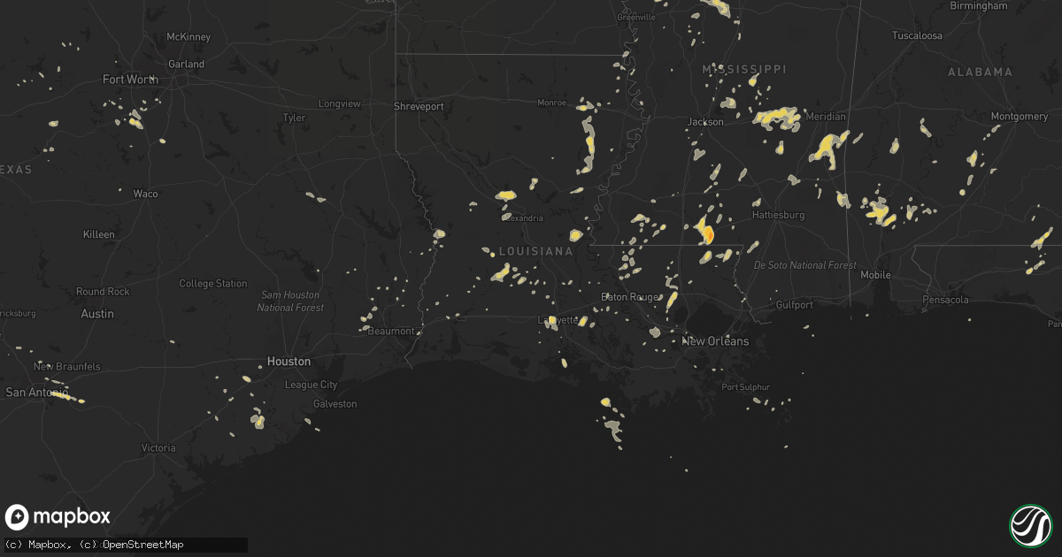
Hail Map on May 31, 2012
Get this storm
May 31 map
$229
one time, instant access
Download today. No call, no setup
Keep the $229
Bought the map and want the full workflow? Apply the entire $229 to a subscription within 7 days. None of it is wasted.
Every map, not just this one
This buys you this map. Subscription and you get every map we run, in the markets you choose from a few cities to whole states to nationwide. Plus real-time alerts the moment a storm fires.
Contact data
Name, contact info, occupancy, even credit band for addresses in the footprint. You go from where it hit to who to call.
Become the source they trust
Unlimited branding weather history reports on demand. You already have the documented answer ready for the property owner, and you are the one who showed up with it.
Property data and RoofTrace estimates
Pull up any address you have got, its value and the exact code rules for that jurisdiction, straight from One Click Code. Then RoofTrace estimates the squares, pitch, and roof value, priced the way you price.
States Impacted by Hail Map on May 31, 2012
Storm reports
Missouri
| Date | Description |
|---|---|
| 05/31/20123:02 PM CDT | A local report indicates 1.00 inch wind near PORTAGEVILLE |
| 05/31/20122:50 PM CDT | A local report indicates 1.00 inch wind near GIDEON |
| 05/31/20122:40 PM CDT | High winds extensively damaged roof of local school. |
Louisiana
| Date | Description |
|---|---|
| 05/31/20123:50 PM CDT | Trees down along hwy 436 near pine |
| 05/31/20123:30 PM CDT | 7 powerlines down on hwy 1 near the valentine bridge. Several trees down. |
| 05/31/20123:08 PM CDT | Co-op observer reported quarter size hail falling in hammond. |
| 05/31/20122:35 PM CDT | Trees down county wide. |
| 05/31/20122:22 PM CDT | A local report indicates 1.00 inch wind near 7 S CLINTON |
| 05/31/20122:19 PM CDT | Powerlines down. Over 2000 customers without power per entergy website. |
| 05/31/20122:16 PM CDT | Powerlines down near kbtr airport |
| 05/31/20121:55 PM CDT | Powerlines down in the area around ferriday. |
| 05/31/20121:24 PM CDT | Large tree limb damaged a car on azalea street in jena. |
| 05/31/20121:21 PM CDT | Report of a tree leaning on power lines at the intersection of elm st and s. 3rd st. |
| 05/31/20121:08 PM CDT | *** 1 inj *** a tree fell on a house on vincent st in opelousas. Along with report there are reports of pea sized hail |
| 05/31/20121:08 PM CDT | Report of a tree leaning on power lines at the intersection of elm st and s. 3rd st. |
| 05/31/201212:54 PM CDT | Sheriff reporting multiple trees down and power lines along hwy 10 |
| 05/31/201212:35 PM CDT | Deputies responded to tree down across roadway. |
| 05/31/201212:23 PM CDT | Multiple trees down in evangeline parish along hwy 104.. Hwy 106... 29 south...beaver rd...oakdale rd |
| 05/31/201212:22 PM CDT | Rapides police relayed report of multiple trees down on cars in alexandria |
| 05/31/201211:58 AM CDT | Trees down across western grant parish |
| 05/31/201211:55 AM CDT | Off duty nws employee reported that a pine tree is down on a power line just north of dequincy la |
| 05/31/201211:37 AM CDT | Report of a few trees down on union church road. |
| 05/31/201211:25 AM CDT | Sheriff reports tree down in singer and pea sized hail just to the south of singer |
Indiana
| Date | Description |
|---|---|
| 05/31/20124:00 PM CDT | A local report indicates 1.00 inch wind near ROCKPORT |
| 05/31/20123:54 PM CDT | A local report indicates 1.00 inch wind near ROCKPORT |
| 05/31/20123:52 PM CDT | A local report indicates 62 MPH wind near ROCKPORT |
Kentucky
| Date | Description |
|---|---|
| 05/31/20126:17 PM CDT | Half inch hail |
| 05/31/20125:42 PM CDT | Tree down across the western kentucky parkway near pea ridge road. |
| 05/31/20125:18 PM CDT | A local report indicates 1.00 inch wind near IRVINGTON |
| 05/31/20125:07 PM CDT | Six inch diameter branch snapped by thunderstorm winds. |
| 05/31/20125:03 PM CDT | Six inch diameter branch snapped by thunderstorm winds. |
| 05/31/20125:01 PM CDT | Between sample and union star. |
| 05/31/20124:44 PM CDT | Trees down with estimated wind gust 60 to 65 mph. Dime to marble size hail reported. |
| 05/31/20124:33 PM CDT | Emergency management reported three trees down across the county. One fell across midway lane in hawesville. |
Arkansas
| Date | Description |
|---|---|
| 05/31/20121:58 PM CDT | Wind gusts 55 to 60 mph on hwy 63. |
| 05/31/20121:47 PM CDT | Estimated 65 mph wind blew out passenger side rear window of car. |
Alabama
| Date | Description |
|---|---|
| 05/31/20126:30 PM CDT | Several trees down. |
| 05/31/20126:15 PM CDT | Shed blown over and rain gutter torn off house on beulah campground rd near excel. |
| 05/31/20124:18 PM CDT | Trees reported down in multiple neighborhoods across montgomery. |
| 05/31/20124:13 PM CDT | On rsa camera in downtown montgomery. |
| 05/31/20123:15 PM CDT | Tree fell on power lines. |
| 05/31/20122:55 PM CDT | Numerous trees down across eastern portion of county. Time estimated by radar. |
New Mexico
| Date | Description |
|---|---|
| 05/30/20129:43 PM CDT | Accumulated over 10 miles of i-25 |
| 05/30/20127:39 PM CDT | A local report indicates 1.50 inch wind near WAGON MOUND |
Georgia
| Date | Description |
|---|---|
| 05/31/20126:50 PM CDT | 911 center reports 5-7 trees down in the thomaston area near highway 19. |
| 05/31/20124:27 PM CDT | Trees down along highway 122. |
| 05/31/20124:10 PM CDT | 911 center reported a tree down blocking u.s. Hwy 1. |
| 05/31/20124:08 PM CDT | 911 center reported a tree down on power lines along moore street. |
| 05/31/20124:05 PM CDT | Trees down around jackson road and highway 76. |
| 05/31/20124:00 PM CDT | Several trees down around coffee and salem roads |
| 05/31/20123:55 PM CDT | Golf ball size hail reported not too far from coolidge |
| 05/31/20123:41 PM CDT | 1 3/4 inch hail reported for thomas county 2 miles sw of merrillville. |
| 05/31/20123:41 PM CDT | Minor roof damage to mobile home from strong thunderstom winds in thomas county. |
| 05/31/20123:40 PM CDT | Quarter sized hail fell on sr 57 1 mile south of the tibet baptist church. Trees also blown down blocking road. |
| 05/31/20123:40 PM CDT | Quarter sized hail fell on sr 57 1 mile south of the tibet baptist church. Trees also blown down blocking road. |
| 05/31/20122:49 PM CDT | Winds reported gusting to 63 mph. Spotter had to pull over on the road. |
| 05/31/20121:11 PM CDT | Tree down across roadway at wildwood drive and smith avenue. Time based on radar. |
| 05/31/201212:57 PM CDT | Quarter sized hail at inersection of highway 30 and highway 21 in port wentworth |
| 05/30/201210:45 PM CDT | 911 call center reported a tree down on liberty church road. |
| 05/30/201210:40 PM CDT | 911 call center reported a tree down on dorrell plott road. |
| 05/30/201210:40 PM CDT | 911 call center reported a tree down near the intersection of gainesville highway and 180e. |
| 05/30/201210:36 PM CDT | Public reported quarter sized hail near hood. |
| 05/30/201210:30 PM CDT | The white county emergency manager reported that a half dozen trees were down in a yard along kellum valley road. |
| 05/30/20128:23 PM CDT | The emergency manager reported that several trees were blown down across southern and southeastern greene county. The trees were all large pine trees...but were either |
| 05/30/20128:18 PM CDT | 911 center reported 1 tree down in the ethridge area. |
| 05/30/20128:03 PM CDT | 911 center reported 1 tree down near the putnam-hancock county line. |
| 05/30/20127:28 PM CDT | 911 center reported several trees and a few power lines down in the city of eatonton. |
| 05/30/20127:15 PM CDT | 911 center reports 1 tree down in concord. |
| 05/30/20127:00 PM CDT | 911 center reports 2 trees down in the molena area. |
Florida
| Date | Description |
|---|---|
| 05/31/20126:25 PM CDT | Several trees were snapped in a very localized area and one tree went into a home. |
| 05/31/20125:54 PM CDT | Powerlines down at south 22nd street and central avenue as well as south 18th street. |
| 05/31/20125:51 PM CDT | Fire rescue reported tree down on seminole woods parkway in southeast palm coast. |
| 05/31/20125:45 PM CDT | Pool enclosure on ocean palm drive destroyed by strong winds. |
| 05/31/20125:30 PM CDT | Resident reported damage to soffits on two homes...landscape structures displaced...and the tops of two trees sheared off. Time of event estimated by radar. |
| 05/31/20123:55 PM CDT | Thunderstorm winds flipped over a carport at ramona blvd and westgate drive. |
| 05/31/20123:30 PM CDT | Broadcast media relayed public report of damage near i-95 and county road 210. Large wooden play house being thrown across yard. Patio furniture thrown into the yard as |
| 05/31/20123:20 PM CDT | Tree down on thomasville road between hermitage blvd and i-10. |
| 05/31/20123:08 PM CDT | Tree fell and blocking the road on durbin creek blvd. Other tree branches and debris on road near davis pond. Time estimated by radar. |
| 05/31/20122:55 PM CDT | Tree fell on a house at mariner street and memorial park road. |
| 05/31/20122:55 PM CDT | Tree down across i-295 just south of i-10. Pea sized hail also reported near pritchard road. |
| 05/31/20122:54 PM CDT | Strong downburst winds downed several trees in a neighborhood just northwest of the i-295 and i-10 intersection. Trees down on homes on mariner street and paschal st. R |
| 05/31/20122:52 PM CDT | Damage to a furniture store on beaver and lane streets with at least a quarter of a tin roof peeled off. |
| 05/31/20122:50 PM CDT | Strong downburst winds removed the roof at the lee and cates glass manufacturing warehouse. Heavy water damage reported inside the facility. Time of event estimated by |
| 05/31/20121:00 PM CDT | Several large oak trees were snapped near the oglesby nursuery on bodiford road...oglesby road and buddy johnson road. There was also roof damage to two of the nursery |
Mississippi
| Date | Description |
|---|---|
| 05/31/20126:03 PM CDT | Reports of trees down countywide. |
| 05/31/20126:00 PM CDT | Trees down in the yard of a house on west gate hill drive |
| 05/31/20125:53 PM CDT | Trees down...one on a house and one on a vehicle. Transformer blown. Occurred near 24th street and 29th ave. |
| 05/31/20125:40 PM CDT | Trees were down on griffis fountain road. |
| 05/31/20125:40 PM CDT | Trees were down on bill addy road. |
| 05/31/20125:26 PM CDT | Trees were down on power lines. |
| 05/31/20125:26 PM CDT | A church had roof damage. |
| 05/31/20125:22 PM CDT | Trees were down on hwy 503 and brand road. |
| 05/31/20125:15 PM CDT | Trees down |
| 05/31/20125:08 PM CDT | Trees were reported down on highway 504 and kennedy road. |
| 05/31/20125:08 PM CDT | Trees were down on gibbstown road. |
| 05/31/20125:08 PM CDT | Tree and powerline down on bill windham road. |
| 05/31/20125:06 PM CDT | Reports of a tree down across hopson trailer road near pearl hodge road. A tree is down on poole creek road and completely blocking the roadway. |
| 05/31/20125:05 PM CDT | Report of a tree down across lynn ray road extension. |
| 05/31/20125:03 PM CDT | Tree down on country circle just off highway 15 with a residential natural gas line ruptured. |
| 05/31/20125:03 PM CDT | Reports of a tree down blocking a roadway across magnolia road at highway 84 east. |
| 05/31/20125:00 PM CDT | Trees down across highway 28 and hines rd in the calhoun community |
| 05/31/20124:59 PM CDT | Report of a tree down blocking roadway in the 800 block of ovett-moselle road. |
| 05/31/20124:55 PM CDT | Trees downed and some shingle damage |
| 05/31/20124:55 PM CDT | Numerous trees down around brooklyn |
| 05/31/20124:52 PM CDT | A few trees and some large tree branches were blown down |
| 05/31/20124:50 PM CDT | Trees down |
| 05/31/20124:50 PM CDT | Trees down on monroe and moselle-seminary roads |
| 05/31/20124:50 PM CDT | A few trees were downed in the city of hattiesburg |
| 05/31/20124:50 PM CDT | Buckatunna building supply store reported quarter size hail. |
| 05/31/20124:41 PM CDT | Reports of several trees down throughout the county. Also pea size hail reported north of lumberton. |
| 05/31/20124:35 PM CDT | Large tree and power lines downed on lott road |
| 05/31/20124:30 PM CDT | Numerous trees down in and around raleigh |
| 05/31/20124:30 PM CDT | Numerous trees down across covington county |
| 05/31/20124:20 PM CDT | Numerous trees down across covington county |
| 05/31/20124:18 PM CDT | Reports of a few trees down in the eupora and mathison area. |
| 05/31/20124:05 PM CDT | Tree down on a garage |
| 05/31/20124:00 PM CDT | Numerous trees down across leake county |
| 05/31/20124:00 PM CDT | Numerous trees and powerlines down around magee. |
| 05/31/20123:50 PM CDT | Reports of a tree down in columbia. Also a building was struck by lightning. |
| 05/31/20123:35 PM CDT | Reported by off duty broadcast meteorologist |
| 05/31/20123:35 PM CDT | 3 trees down inside the monticello city limits. 2 fell on homes. |
| 05/31/20123:33 PM CDT | Tree down on a vehicle...caused minor dmg. |
| 05/31/20123:31 PM CDT | Reports of trees and powerlines down throughout southern copiah county. |
| 05/31/20123:30 PM CDT | *** 4 inj *** numerous trees down in and southwest of hazlehurst. 4 people sustained minor injuries as a branch went through a homes window. |
| 05/31/20123:27 PM CDT | Numerous trees down in and southwest of hazlehurst |
| 05/31/20123:26 PM CDT | Reports of a tree down on rice road. Also pea size to dime size hail reported near liberty park. Power out at traffic lights along rice road. |
| 05/31/20123:22 PM CDT | Reports of a few trees down in canton and in nearby farmhaven. |
| 05/31/20123:20 PM CDT | Tylertown fire dept reported golf ball size hail |
| 05/31/20123:03 PM CDT | Report of a powerline and some small limbs down in winona. |
| 05/31/20122:55 PM CDT | Trees down and part of a metal roof or porch off a building. Also utility company shows powerlines down. |
| 05/31/20122:45 PM CDT | Reports of tree down at the intersection of sweethome road and hillside road. |
| 05/31/20122:30 PM CDT | Trees down across hwy 35 north and south of carrollton. Tree down across powerlines causing powerline to come down. Transformer blown. |
| 05/31/20122:13 PM CDT | Report of a tree down across lakeside drive. |
| 05/31/20122:04 PM CDT | Reports of a tree down on providence road. |
| 05/31/20122:00 PM CDT | Trees and powerlines down |
| 05/31/20121:45 PM CDT | Powerlines down |
Texas
| Date | Description |
|---|---|
| 05/31/20126:44 PM CDT | A local report indicates 2.75 inch wind near 5 NE FORT DAVIS |
| 05/31/20122:00 PM CDT | Quarter sized hail reported on the west side of rosenberg. |
| 05/31/20121:28 PM CDT | Quarter sized hail reported west of rosenberg. |
| 05/30/20127:50 PM CDT | A local report indicates 1.00 inch wind near ALPINE |
| 05/30/20127:33 PM CDT | A local report indicates 1.75 inch wind near 12 SW FORT DAVIS |
Tennessee
| Date | Description |
|---|---|
| 05/31/20123:30 PM CDT | An 8 by 10 shed was blown 30 yards near intersection of walker parkway and edith. |
| 05/31/20123:15 PM CDT | Several trees...6 to 8 inches in diameter down in shelby forest area...walsh road...woodstock cuba road and garnet road. |
| 05/31/20123:00 PM CDT | A few small trees blown over near hwy 14 east of millington. |
| 05/31/20122:48 PM CDT | *** 1 inj *** tree fell on mobile home located on raleigh millington road. 1 minor injury...knot on head. |
| 05/30/20129:10 PM CDT | Some trees blown down throughout county. |
| 05/30/20129:02 PM CDT | Trees down 8 ne of lebanon. |
| 05/30/20128:50 PM CDT | Several trees blown down on north russell street in portland |
| 05/30/20128:47 PM CDT | Multiple trees down in the gallatin area. Power lines down as well with power loss in the city. |
| 05/30/20128:35 PM CDT | Emgr mgr reports tree down across road at 2938 benders ferry rd. |
| 05/30/20128:24 PM CDT | Tree fell on 4 cars at 860 murfreesboro pike. Report by metro nashville oem. |
| 05/30/20128:24 PM CDT | Tree fell on 4 cars at 860 murfreesboro pike. Report by metro nashville oem. |
| 05/30/20128:20 PM CDT | Numerous trees blown down just west of nashville airport including on radford drive...catina drive...and drummond drive |
| 05/30/20128:15 PM CDT | Tree fell on 4 cars at 860 murfreesboro pike in hermitage. Report from metro oem. |
| 05/30/20128:15 PM CDT | Multiple trees and power lines down in metro nashville. Reported by nashville oem. |
| 05/30/20127:05 PM CDT | Dispatch and media reported several trees down across the county. |
Cities Impacted by Hail Map on May 31, 2012
- Defuniak Springs, FL
- Oakdale, LA
- Oberlin, LA
- Mitchell, GA
- Boncarbo, CO
- Weston, CO
- Trinidad, CO
- Sontag, MS
- Monticello, MS
- Dahlonega, GA
- Delhi, LA
- Frisco City, AL
- Chatom, AL
- Sour Lake, TX
- Waynesboro, TN
- Troy, TN
- Obion, TN
- Brunswick, GA
- Hortense, GA
- Carthage, MS
- Elba, AL
- Green Cove Springs, FL
- Live Oak, FL
- Sicily Island, LA
- Milford, TX
- Mccomb, MS
- Jayess, MS
- Tylertown, MS
- Winnsboro, LA
- Gilbert, LA
- Sweet Water, AL
- Dixons Mills, AL
- Trementina, NM
- Clarkton, MO
- Gideon, MO
- Mount Juliet, TN
- Wellborn, FL
- McAlpin, FL
- Lake City, FL
- Horse Branch, KY
- Caneyville, KY
- Gibson, MO
- Campbell, MO
- Piggott, AR
- Portageville, MO
- Holcomb, MO
- Saint Francis, AR
- Lawrence, MS
- Conehatta, MS
- Hickory, MS
- Pulaski, MS
- Forest, MS
- Lake, MS
- Morton, MS
- Newton, MS
- Decatur, MS
- Lowndesboro, AL
- Hayneville, AL
- San Antonio, TX
- Centreville, MS
- Cleburne, TX
- Keene, TX
- Barney, GA
- Adel, GA
- Cleveland, GA
- Alpine, TX
- Cedar Hill, TN
- Springfield, TN
- Cloutierville, LA
- Colfax, LA
- Dry Prong, LA
- Fredonia, KY
- Saint Martinville, LA
- Fort Davis, TX
- Owensboro, KY
- Stephensport, KY
- Hawesville, KY
- Union Star, KY
- Lewisport, KY
- Maceo, KY
- Rockport, IN
- Hardinsburg, KY
- Cannelton, IN
- Webster, KY
- Shelby, MS
- Fitzgerald, GA
- Chrisney, IN
- Richland, IN
- Terry, MS
- Talbotton, GA
- Ferriday, LA
- Jonesville, LA
- Forest Home, AL
- Pine Apple, AL
- Greenville, AL
- Minter, AL
- Alto, TX
- Wells, TX
- Pollok, TX
- Mayfield, KY
- Wagarville, AL
- Sunflower, AL
- McIntosh, AL
- White Oak, GA
- Woodbine, GA
- Belzoni, MS
- Tchula, MS
- East Prairie, MO
- Samson, AL
- Geneva, AL
- Coffee Springs, AL
- Ponce De Leon, FL
- Searcy, AR
- Lyles, TN
- Bon Aqua, TN
- Fairview, TN
- Meridian, MS
- Vossburg, MS
- Shubuta, MS
- Pachuta, MS
- Waynesboro, MS
- Heidelberg, MS
- Lisman, AL
- Butler, AL
- Quitman, MS
- Moscow, TN
- Lafayette, LA
- Scott, LA
- Cordova, TN
- Collierville, TN
- Germantown, TN
- Eads, TN
- Thomasville, GA
- Boston, GA
- Coolidge, GA
- Pavo, GA
- Liberty, MS
- Osyka, MS
- Savannah, GA
- Wagon Mound, NM
- Ocate, NM
- Rosenberg, TX
- Ekron, KY
- Fort Stewart, GA
- Springer, NM
- Black Oak, AR
- Leesville, LA
- Deridder, LA
- Marion, KY
- Clay, KY
- Groveland, FL
- Laurel, MS
- Twin City, GA
- Swainsboro, GA
- Gloster, MS
- Crosby, MS
- Rayville, LA
- Slaughter, LA
- Zachary, LA
- Ethel, LA
- Clinton, LA
- Beaver Dam, KY
- Cromwell, KY
- Morgantown, KY
- Pitkin, LA
- Raton, NM
- Earle, AR
- Anacoco, LA
- Grapeland, TX
- Center Point, TX
- Alvarado, TX
- Venus, TX
- Dawson Springs, KY
- Crofton, KY
- Saint Charles, KY
- Tibbie, AL
- Leroy, AL
- Saint Stephens, AL
- State Line, MS
- Fruitdale, AL
- Millry, AL
- Buckatunna, MS
- Garita, NM
- Orange, TX
- La Vernia, TX
- Ludowici, GA
- Atmore, AL
- Saint Hedwig, TX
- Adkins, TX
- Rose Hill, MS
- Princeton, KY
- Cerulean, KY
- Burkeville, TX
- Uriah, AL
- Bay City, TX
- Port Wentworth, GA
- Ellabell, GA
- Bloomingdale, GA
- Pooler, GA
- Wingo, KY
- Clinton, KY
- Tallahassee, FL
- Moultrie, GA
- Hammond, LA
- Springfield, LA
- Holden, LA
- Drakesboro, KY
- Browder, KY
- Belton, KY
- Saint Augustine, FL
- Trout, LA
- Ellisville, MS
- Norwood, LA
- Wilson, LA
- Williston, TN
- Jackson, LA
- Jbsa Randolph, TX
- Cibolo, TX
- Universal City, TX
- Schertz, TX
- Philipp, MS
- Charleston, MS
- West Columbia, TX
- Sweeny, TX
- Fairdale, KY
- Shaw, MS
- Canton, MS
- El Campo, TX
- Palm Coast, FL
- Hastings, FL
- Evergreen, AL
- Irvington, KY
- Brandenburg, KY
- Guston, KY
- Clayton, LA
- Baskin, LA
- Faunsdale, AL
- Linden, AL
- Milledgeville, GA
- Grandview, TX
- Opelousas, LA
- Quitman, GA
- Morven, GA
- Geneva, FL
- Mims, FL
- Turrell, AR
- Greenwood, MS
- Carrollton, MS
- Coila, MS
- Indianola, MS
- Lake Providence, LA
- McRae Helena, GA
- Minter City, MS
- Clarksdale, MS
- Duncan, MS
- Tutwiler, MS
- Camden, AL
- Fancy Farm, KY
- Jackson, AL
- Memphis, TN
- Jacksonville, FL
- Warrenton, GA
- Alamo, GA
- Deer Park, AL
- Hahira, GA
- Berlin, GA
- Fisherville, KY
- Godley, TX
- Buna, TX
- Boerne, TX
- Bergheim, TX
- Gunnison, MS
- Catherine, AL
- Jacksboro, TX
- Stockdale, TX
- Drew, MS
- Valdosta, GA
- Duson, LA
- Fred, TX
- De Leon Springs, FL
- Maxwell, NM
- Tickfaw, LA
- Independence, LA
- Albany, LA
- Bunnell, FL
- Hollandale, MS
- Greenville, MS
- Crawford, TX
- Valley Mills, TX
- Palo Pinto, TX
- Gordon, TX
- Kirbyville, TX
- Madison, MS
- Bay Springs, MS
- Louin, MS
- Fleming Island, FL
- Orange Park, FL
- Marksville, LA
- Moreauville, LA
- Augusta, AR
- Sumrall, MS
- Garyville, LA
- Quincy, FL
- Pollock, LA
- Graford, TX
- Naylor, GA
- Lexa, AR
- West Helena, AR
- Stephenville, TX
- Gainestown, AL
- Gilmore, AR
- Crawfordsville, AR
- Krotz Springs, LA
- Westlake, LA
- Taylorsville, KY
- Allenhurst, GA
- Tell City, IN
- Troy, IN
- Millington, TN
- Arlington, TN
- Mound Bayou, MS
- Snow Lake, AR
- Alligator, MS
- Boyle, MS
- Perrin, TX
- Lena, MS
- Brandon, MS
- Silver Creek, MS
- Erath, LA
- Thomaston, GA
- Fordoche, LA
- Damon, TX
- Franklinton, LA
- Frankfort, KY
- Mamou, LA
- Livingston, LA
- Eunice, LA
- Galveston, TX
- Heth, AR
- Widener, AR
- West, MS
- Richmond, TX
- Jackson, MS
- Thomasville, AL
- Strawn, TX
- Oak Grove, LA
- Sturgis, KY
- Providence, KY
- Dixon, KY
- Raleigh, MS
- Macclenny, FL
- La Place, LA
- Crystal Springs, MS
- Balmorhea, TX
- New Orleans, LA
- Middleburg, FL
- Ville Platte, LA
- Maurice, LA
- Youngsville, LA
- Rayne, LA
- Elizabeth, IN
- Laconia, IN
- Walnut Grove, MS
- Rolling Fork, MS
- Ray City, GA
- Chunky, MS
- Schlater, MS
- Maurepas, LA
- Howey In The Hills, FL
- Louisville, KY
- Devers, TX
- Summertown, TN
- Lawrenceburg, TN
- Ethridge, TN
- Pierson, FL
- Astor, FL
- Cedar Hill, TX
- Grosse Tete, LA
- Owenton, KY
- Waddy, KY
- Shelbyville, KY
- Hughes, AR
- Hornbeak, TN
- Osteen, FL
- Boyce, LA
- Marion, TX
- Seguin, TX
- Blowing Rock, NC
- Boone, NC
- Kountze, TX
- Kaplan, LA
- Vaiden, MS
- Needville, TX
- Mount Olive, MS
- Prentiss, MS
- Magee, MS
- Kinston, AL
- Sanderson, FL
- Blum, TX
- Westville, FL
- Venice, LA
- Newton, TX
- Eagle Lake, TX
- Meadville, MS
- Bude, MS
- Starke, FL
- Sparta, GA
- Eatonton, GA
- Paulina, LA
- Saint James, LA
- Convent, LA
- Church Point, LA
- Buras, LA
- Conchas Dam, NM
- Chipley, FL
- Saint Amant, LA
- Gonzales, LA
- Pleasant View, TN
- Bluffton, GA
- Ochlocknee, GA
- Angie, LA
- Philpot, KY
- Dry Creek, LA
- Simpsonville, KY
- Finchville, KY
- Smithdale, MS
- Sunset, LA
- Cloverport, KY
- Derby, IN
- Payneville, KY
- Rome, IN
- Battletown, KY
- Mauckport, IN
- Corydon, IN
- Rhodelia, KY
- Harned, KY
- Benton, MS
- Pickens, MS
- Call, TX
- Bainbridge, GA
- Hahnville, LA
- Baton Rouge, LA
- Port Barre, LA
- Washington, LA
- Azle, TX
- Wharton, TX
- Greensburg, LA
- Amite, LA
- Seminary, MS
- Cairo, GA
- Tallulah, LA
- Vine Grove, KY
- Rineyville, KY
- Custer, KY
- Belle Chasse, LA
- Dublin, TX
- Marked Tree, AR
- Tyronza, AR
- Dequincy, LA
- Kokomo, MS
- Foxworth, MS
- Altha, FL
- Longwood, FL
- Oak Vale, MS
- Vicksburg, MS
- Mount Hermon, LA
- White Castle, LA
- Columbia, MS
- Benoit, MS
- Cleveland, MS
- McKenzie, AL
- Georgiana, AL
- Newhebron, MS
- Sycamore, GA
- Chula, GA
- Pelahatchie, MS
- Robinsonville, MS
- Brookhaven, MS
- Livingston, TX
- Junction City, GA
- Loranger, LA
- Granbury, TX
- Sidon, MS
- Itta Bena, MS
- Uniontown, AL
- Junction, TX
- Port Allen, LA
- Ormond Beach, FL
- Radcliff, KY
- Lena, LA
- Bentley, LA
- North Carrollton, MS
- Winona, MS
- Vaughan, MS
- Midlothian, TX
- Erin, TN
- Pinola, MS
- O'Brien, FL
- Harrisonburg, LA
- Meigs, GA
- Lafitte, LA
- Metter, GA
- Rossville, TN
- Butler, GA
- Vance, MS
- Thibodaux, LA
- Nortonville, KY
- Grand Ridge, FL
- Marianna, FL
- Ruth, MS
- Lumberton, MS
- Poplarville, MS
- Atoka, TN
- Sulphur, LA
- La Grange, TX
- Waverly, AL
- Dauphin Island, AL
- Bulverde, TX
- Saint Johns, FL
- Ponte Vedra, FL
- Florence, MS
- Harrisville, MS
- Oakland, TN
- Summit, MS
- Waverly, GA
- Eudora, AR
- Converse, TX
- Blairsville, GA
- Murrayville, GA
- Arlington, TX
- Mount Washington, KY
- Shepherdsville, KY
- Flagler Beach, FL
- Chancellor, AL
- Elmer, LA
- Alexandria, LA
- Ragley, LA
- Raymond, MS
- Jachin, AL
- Hardeeville, SC
- Crowley, TX
- Crestwood, KY
- Joshua, TX
- Abbeville, LA
- Caddo, TX
- Falls Of Rough, KY
- Alberta, AL