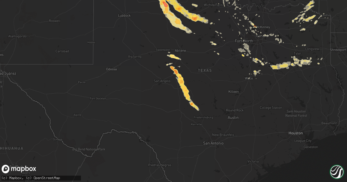
Hail Map in Texas on May 30, 2012
Get this storm
May 30 map
$229
one time, instant access
Download today. No call, no setup
Keep the $229
Bought the map and want the full workflow? Apply the entire $229 to a subscription within 7 days. None of it is wasted.
Every map, not just this one
This buys you this map. Subscription and you get every map we run, in the markets you choose from a few cities to whole states to nationwide. Plus real-time alerts the moment a storm fires.
Contact data
Name, contact info, occupancy, even credit band for addresses in the footprint. You go from where it hit to who to call.
Become the source they trust
Unlimited branding weather history reports on demand. You already have the documented answer ready for the property owner, and you are the one who showed up with it.
Property data and RoofTrace estimates
Pull up any address you have got, its value and the exact code rules for that jurisdiction, straight from One Click Code. Then RoofTrace estimates the squares, pitch, and roof value, priced the way you price.
Storm reports in Texas
Texas
| Date | Description |
|---|---|
| 05/30/20126:56 PM CDT | A local report indicates 60 MPH wind near 1 W PAINT ROCK |
| 05/30/20126:50 PM CDT | A local report indicates 70 MPH wind near 3 W TRUSCOTT |
| 05/30/20126:47 PM CDT | Rain wrapped tornado reported approximately 5 miles ene of paint rock on rural road 1929 |
| 05/30/20126:38 PM CDT | Brief tornado along the runnels and concho county line approximately 2 miles east of us 83. |
| 05/30/20126:33 PM CDT | Dime to quarter size hail near lawn |
| 05/30/20126:28 PM CDT | Storm chaser reported a large rain-wrapped tornado. Location is estimated. |
| 05/30/20126:27 PM CDT | A local report indicates 60 MPH wind near 3 W TRUSCOTT |
| 05/30/20126:27 PM CDT | A local report indicates 1.75 inch wind near 3 E OVALO |
| 05/30/20126:25 PM CDT | A local report indicates 1.75 inch wind near TUSCOLA |
| 05/30/20126:10 PM CDT | Pea to quarter size hail in town |
| 05/30/20126:08 PM CDT | A local report indicates 1.75 inch wind near BALLINGER |
| 05/30/20126:05 PM CDT | A local report indicates 2.75 inch wind near BALLINGER |
| 05/30/20126:00 PM CDT | Golf ball size hail at abilene state park |
| 05/30/20126:00 PM CDT | Report relayed through local broadcast media |
| 05/30/20125:59 PM CDT | Estimated 80-90 mph winds in paducah. Power is out and several reports of trees down. |
| 05/30/20125:59 PM CDT | Reports of full trees uprooted...sheet metal flying through air...possible combination straight line winds and gustnado |
| 05/30/20125:58 PM CDT | A local report indicates 1.75 inch wind near 10 S CHILDRESS |
| 05/30/20125:49 PM CDT | A local report indicates 4.50 inch wind near 6 NE PADUCAH |
| 05/30/20125:42 PM CDT | Hail reported at prison southwest of childress |
| 05/30/20125:40 PM CDT | A local report indicates 2.75 inch wind near 7 NE PADUCAH |
| 05/30/20125:31 PM CDT | A local report indicates 1.75 inch wind near 12 W BUFFALO GAP |
| 05/30/20125:30 PM CDT | A local report indicates 2.75 inch wind near 5 NE NORTON |
| 05/30/20125:28 PM CDT | Quarter to baseball size hail at coronado camp at the junction of us 277 and rural road 89 |
| 05/30/20125:27 PM CDT | A local report indicates 4.50 inch wind near 12 N PADUCAH |
| 05/30/20125:22 PM CDT | Quarter size hail along highway 83 north of paducah |
| 05/30/20125:20 PM CDT | Reported on highway 287 near the hall and childress county line |
| 05/30/20125:10 PM CDT | Nickel to quarter size hail falling. |
| 05/30/20124:55 PM CDT | A local report indicates 1.00 inch wind near 16 N MCLEAN |
| 05/30/20124:50 PM CDT | A local report indicates 1.50 inch wind near 18 N HEDLEY |
| 05/30/20124:36 PM CDT | A local report indicates 3.00 inch wind near 5 NNW ESTELLINE |
| 05/30/20124:25 PM CDT | Barns damaged...power lines down...home with roof removed...trailers blown over. No injuries. |
| 05/30/20124:12 PM CDT | A local report indicates 2.75 inch wind near 1 N LEFORS |
| 05/30/20124:01 PM CDT | A local report indicates 1.00 inch wind near 5 S HEDLEY |
| 05/30/20124:00 PM CDT | A local report indicates 1.00 inch wind near HEDLEY |
| 05/30/20124:00 PM CDT | A local report indicates 2.00 inch wind near 7 S LELIA LAKE |
| 05/30/20123:58 PM CDT | A local report indicates 1.75 inch wind near 7 S HEDLEY |
| 05/30/20123:17 PM CDT | Along hwy 380 between crossroads and prosper |
| 05/30/201210:40 AM CDT | Dime to quarter sized hail fell for several minutes at the intersection of hwy 377 and industrial park |
| 05/30/20127:00 AM CDT | Ping pong to golfball size hail reported in and west of cleburne |
| 05/30/201212:15 AM CDT | A local report indicates 1.25 inch wind near FATE |
| 05/30/201212:15 AM CDT | A local report indicates 1.00 inch wind near ROYSE CITY |
| 05/29/201210:20 PM CDT | Large trees downed in mineral wells knocked power out to s.e. Side of town |
| 05/29/201210:00 PM CDT | A local report indicates 2.75 inch wind near 6 WSW MASON |
| 05/29/20129:58 PM CDT | Trained spotter estimates 60 mph winds east of loving near jermyn. |
| 05/29/20129:55 PM CDT | Measured at krph |
| 05/29/20129:47 PM CDT | Near the county line |
| 05/29/20129:47 PM CDT | A local report indicates 60 MPH wind near OLNEY |
| 05/29/20129:44 PM CDT | A local report indicates 60 MPH wind near WESTOVER |
| 05/29/20129:44 PM CDT | A local report indicates 1.25 inch wind near WESTOVER |
| 05/29/20129:43 PM CDT | A local report indicates 1.50 inch wind near 4 SW MASON |
| 05/29/20129:31 PM CDT | A local report indicates 60 MPH wind near OLNEY |
| 05/29/20129:31 PM CDT | A local report indicates 1.00 inch wind near OLNEY |
| 05/29/20129:25 PM CDT | A local report indicates 77 MPH wind near 1 NNW HASKELL |
| 05/29/20129:00 PM CDT | Golf ball to tennis ball size hail near the intersection of us 190 and ranch road 1311 |
| 05/29/20129:00 PM CDT | Hail is mostly around the size of quarters with larger stones mixed in. Hail is ongoing. |
| 05/29/20128:59 PM CDT | A local report indicates 1.00 inch wind near KNOX CITY |
| 05/29/20128:45 PM CDT | Quarter size hail reported along highway 183 near throckmorton and baylor county line. |
| 05/29/20128:45 PM CDT | A local report indicates 2.75 inch wind near 12 SSE SEYMOUR |
| 05/29/20128:32 PM CDT | Corn crops stripped. |
| 05/29/20128:30 PM CDT | Wind driven baseball size hail produced extensive damage in melvin. East facing windows were all blown in on several residences |
| 05/29/20128:30 PM CDT | Wind driven baseball size hail produced extensive damage in melvin. East facing windows were all blown in on several residences |
| 05/29/20128:30 PM CDT | Roof damage was sustained at at least one residence near melvin. Damage occurred just east of ranch road 2028 approximately 3 mile south of melvin. |
| 05/29/20128:19 PM CDT | Located along highway 82 east of the intersection with state highway 222 |
| 05/29/20128:10 PM CDT | A local report indicates 60 MPH wind near BOMARTON |
| 05/29/20128:10 PM CDT | A local report indicates 1.75 inch wind near BOMARTON |
| 05/29/20128:05 PM CDT | Wall cloud observed in addition to golf ball size hail |
| 05/29/20127:55 PM CDT | Also reports of very strong winds but no speed estimate |
| 05/29/20127:46 PM CDT | A local report indicates 58 MPH wind near SHEPPARD AFB |
| 05/29/20127:43 PM CDT | Golfball to baseball size hail falling |
| 05/29/20127:40 PM CDT | A local report indicates 4.50 inch wind near 10 S PADUCAH |
| 05/29/20127:32 PM CDT | A local report indicates 2.75 inch wind near 10 S PADUCAH |
| 05/29/20127:30 PM CDT | West texas mesonet station |
| 05/29/20127:30 PM CDT | Broken skylights and limbs 1-2 inches healthy pecan tree. |
| 05/29/20127:26 PM CDT | A local report indicates 2.75 inch wind near 6 SW PADUCAH |
| 05/29/20127:24 PM CDT | A local report indicates 2.75 inch wind near 3 W TRUSCOTT |
| 05/29/20127:20 PM CDT | A local report indicates 2.75 inch wind near 5 W PADUCAH |
| 05/29/20127:20 PM CDT | Several road signs blown over in the millersview area. |
| 05/29/20127:20 PM CDT | Brief touchdown |
| 05/29/20127:18 PM CDT | Brief tornado developed and dissipated just south of highway 62 |
| 05/29/20127:17 PM CDT | A local report indicates 2.75 inch wind near MILLERSVIEW |
| 05/29/20127:15 PM CDT | West texas mesonet station |
| 05/29/20127:00 PM CDT | Nickel to baseball size hail near the rural road 1929 bridge |
All States Impacted by Hail Map on May 30, 2012
Cities Impacted by Hail Map on May 30, 2012
- Wilson, OK
- Braman, OK
- Medford, OK
- Caldwell, KS
- South Haven, KS
- Rozel, KS
- Mobile, AL
- Ryan, OK
- Long Branch, TX
- Gary, TX
- Roe, AR
- Clarendon, AR
- Holly Grove, AR
- Nelson, NE
- Ruskin, NE
- Idabel, OK
- Ballinger, TX
- Norton, TX
- Winters, TX
- Jacksonville, TX
- Wellfleet, NE
- North Platte, NE
- Hershey, NE
- Wynona, OK
- Ramona, OK
- Shidler, OK
- Burbank, OK
- Ochelata, OK
- Barnsdall, OK
- Pawhuska, OK
- Bartlesville, OK
- Juniata, NE
- Victoria, KS
- Colby, KS
- Levant, KS
- Brewster, KS
- Winona, KS
- Paducah, TX
- Pampa, TX
- Maize, KS
- Wichita, KS
- Little Elm, TX
- Lawrence, NE
- Deweese, NE
- Hutchinson, KS
- Humnoke, AR
- Stuttgart, AR
- Ulm, AR
- Carlisle, AR
- De Valls Bluff, AR
- Republic, MO
- Billings, MO
- Collyer, KS
- Delhi, LA
- Newellton, LA
- Winnsboro, LA
- Brookville, KS
- Geneseo, KS
- Bushton, KS
- Lorraine, KS
- Holyrood, KS
- Lyons, KS
- Seymour, TX
- Mcpherson, KS
- Coolidge, TX
- Carterville, MO
- Webb City, MO
- Oronogo, MO
- Jasper, MO
- Joplin, MO
- Alba, MO
- Carthage, MO
- Purcell, MO
- Big Sandy, TX
- Mankato, KS
- Webber, KS
- Ellis, KS
- Scott City, KS
- Leoti, KS
- Electra, TX
- Benton, KS
- Andale, KS
- Colwich, KS
- Mount Hope, KS
- Russell, KS
- Ellsworth, KS
- Lincoln, KS
- Sylvan Grove, KS
- Wilson, KS
- Kanopolis, KS
- Okemah, OK
- Mount Calm, TX
- Axtell, TX
- Mclean, TX
- Chunchula, AL
- Saraland, AL
- Mount Vernon, AL
- Minneapolis, KS
- Miltonvale, KS
- Clay Center, KS
- Watson, AR
- Esbon, KS
- Downs, KS
- Deerfield, KS
- Theodore, AL
- Brownell, KS
- Alexander, KS
- La Crosse, KS
- Nekoma, KS
- Ness City, KS
- Rush Center, KS
- Bazine, KS
- Wellington, KS
- Liberal, KS
- Hugoton, KS
- Strawn, TX
- Coldwater, KS
- Oakley, KS
- Haven, KS
- Atwood, KS
- Oberlin, KS
- Buhler, KS
- Bullard, TX
- Tyler, TX
- Troup, TX
- Flint, TX
- Canton, KS
- Lexington, NE
- Elwood, NE
- Rockwall, TX
- Otis, KS
- Childress, TX
- Quanah, TX
- Crowell, TX
- Wingate, TX
- Tuscola, TX
- Merkel, TX
- Westmoreland, KS
- Minden, NE
- Old Glory, TX
- Medicine Lodge, KS
- Hunter, KS
- Melvin, TX
- Brady, TX
- Gate, OK
- Forgan, OK
- Memphis, TX
- Hawthorne, FL
- Citra, FL
- Fort McCoy, FL
- Holdrege, NE
- Loomis, NE
- Bertrand, NE
- Jetmore, KS
- Barnes, KS
- Waterville, KS
- Randolph, KS
- Greenleaf, KS
- Olsburg, KS
- Blue Rapids, KS
- Millersview, TX
- Burdett, KS
- Simmesport, LA
- Maywood, NE
- Abilene, TX
- Lawn, TX
- Ovalo, TX
- Pratt, KS
- Belpre, KS
- Haviland, KS
- Lewis, KS
- Byers, KS
- Hubbard, TX
- Fort Worth, TX
- Bronte, TX
- Tulsa, OK
- Sapulpa, OK
- Sand Springs, OK
- Aubrey, TX
- Milo, MO
- Nevada, MO
- Gorham, KS
- Liebenthal, KS
- Bison, KS
- Hays, KS
- Schoenchen, KS
- Pfeifer, KS
- Cruger, MS
- Lexington, MS
- Red Rock, OK
- McCracken, KS
- Ransom, KS
- Wright, KS
- Saint Jo, TX
- Nocona, TX
- Wills Point, TX
- Terrell, TX
- Quinlan, TX
- Highlandville, MO
- Ponce De Leon, MO
- Galena, MO
- Ozark, MO
- Spokane, MO
- Reeds Spring, MO
- Eden, TX
- Moss Point, MS
- Upland, NE
- Hildreth, NE
- Campbell, NE
- Larned, KS
- Roanoke, TX
- O'Brien, FL
- McAlpin, FL
- Live Oak, FL
- De Kalb, TX
- Burrton, KS
- Axtell, NE
- Cleburne, TX
- Wagoner, OK
- Vidalia, LA
- Delphos, KS
- Glasco, KS
- Concordia, KS
- Aurora, KS
- Wesson, MS
- Yazoo City, MS
- Reeds, MO
- Sarcoxie, MO
- Talala, OK
- Hooker, OK
- Paint Rock, TX
- Hominy, OK
- Frisco, TX
- Hendley, NE
- Beaver City, NE
- Vicksburg, MS
- Sondheimer, LA
- Valley Park, MS
- Tallulah, LA
- Mayersville, MS
- Sawyer, KS
- Barnard, KS
- Mason, TX
- Tyrone, OK
- Wickes, AR
- Grannis, AR
- Ellinwood, KS
- Hudson, KS
- Loving, TX
- Holcomb, KS
- Royse City, TX
- Tennessee Colony, TX
- Athens, TX
- Montalba, TX
- Palestine, TX
- Streetman, TX
- Fairfield, TX
- Spearville, KS
- Beeler, KS
- Hanston, KS
- Hillsboro, KS
- Eustis, NE
- Geary, OK
- Cimarron, KS
- Inman, KS
- Nickerson, KS
- Moundridge, KS
- Belle Plaine, KS
- Cozad, NE
- Deport, TX
- Indianola, NE
- Lebanon, NE
- McCook, NE
- Culbertson, NE
- Bethany, OK
- Oklahoma City, OK
- Dodge City, KS
- Eight Mile, AL
- Lyndon, KS
- Green, KS
- Morganville, KS
- Guide Rock, NE
- Funk, NE
- Beckville, TX
- Panama City, FL
- Youngstown, FL
- Marienthal, KS
- Voss, TX
- Rowena, TX
- Hext, TX
- Lohn, TX
- Cambridge, KS
- St John, KS
- Macksville, KS
- Sanger, TX
- Valley View, TX
- Pilot Point, TX
- Bogata, TX
- Luray, KS
- Leon, KS
- Blue Hill, NE
- Rosedale, MS
- Park, KS
- Hoxie, KS
- Quinter, KS
- Protection, KS
- Ashland, KS
- Axis, AL
- Sparta, MO
- Seymour, MO
- Butler, AL
- Silver Springs, FL
- Halstead, KS
- Andover, KS
- Derby, KS
- Goddard, KS
- Bentley, KS
- Mcconnell Afb, KS
- Sedgwick, KS
- Augusta, KS
- Valley Center, KS
- Garden Plain, KS
- Rose Hill, KS
- Randall, KS
- Beloit, KS
- Throckmorton, TX
- Frederick, OK
- Soperton, GA
- Rochester, TX
- O'Brien, TX
- Knox City, TX
- Barry, TX
- Purdon, TX
- Silver Lake, KS
- Topeka, KS
- Simms, TX
- Waukomis, OK
- Englewood, KS
- McDonald, KS
- Laneville, TX
- Ensign, KS
- Winfield, KS
- Rock, KS
- Plano, TX
- Richardson, TX
- Homer, LA
- Wauneta, NE
- Hayes Center, NE
- Palisade, NE
- Monument, KS
- Hastings, OK
- Temple, OK
- Randlett, OK
- Walters, OK
- Waurika, OK
- Byers, TX
- Chipley, FL
- Olney, TX
- Lakeview, TX
- Munday, TX
- Goree, TX
- Holliday, TX
- Newcastle, TX
- Tell, TX
- Tichnor, AR
- Florence, MS
- Partridge, KS
- Harper, KS
- Spivey, KS
- Frankston, TX
- Windom, KS
- Sterling, KS
- Douglass, KS
- El Dorado, KS
- Peck, KS
- Hesston, KS
- Galva, KS
- Little River, KS
- Haysville, KS
- Clearwater, KS
- Towanda, KS
- Atlanta, KS
- Newton, KS
- Natchez, MS
- Jacksboro, TX
- Bryson, TX
- Mingus, TX
- Great Bend, KS
- Roxie, MS
- Burr Oak, KS
- Gothenburg, NE
- Avery, TX
- Annona, TX
- Wallace, KS
- Chickasha, OK
- Marquette, KS
- Frisco City, AL
- Waco, TX
- Elm Mott, TX
- Gaylord, KS
- Belzoni, MS
- Brookhaven, MS
- Iuka, KS
- Clarksville, TX
- Meade, KS
- Viola, KS
- Cheney, KS
- Superior, NE
- Branson, MO
- Larue, TX
- Selden, KS
- Jewell, KS
- Olmitz, KS
- Bunker Hill, KS
- Hoisington, KS
- Haworth, OK
- Broken Bow, OK
- Garvin, OK
- Montezuma, KS
- Milford, TX
- Frost, TX
- Italy, TX
- Henderson, TX
- Stamford, TX
- Brady, NE
- Prue, OK
- Skiatook, OK
- Osage, OK
- Wichita Falls, TX
- Defuniak Springs, FL
- Clarendon, TX
- Hedley, TX
- Almyra, AR
- Rose Bud, AR
- Quitman, AR
- Weir, KS
- Fowler, KS
- Gilbertown, AL
- Needham, AL
- Toxey, AL
- Carl Junction, MO
- Golden City, MO
- Galena, KS
- Neck City, MO
- Tryon, NE
- Henrietta, TX
- Haskell, TX
- Holbrook, NE
- Smithfield, NE
- Overton, NE
- De Witt, AR
- Bogue Chitto, MS
- Lindsborg, KS
- Falun, KS
- Franklin, NE
- Robertsdale, AL
- Hennessey, OK
- Price, TX
- Diamond, MO
- Searcy, AR
- Blooming Grove, TX
- Abilene, KS
- Solomon, KS
- Anthony, FL
- Ocala, FL
- Franklin, AR
- Violet Hill, AR
- Newkirk, OK
- La Russell, MO
- Miller, MO
- Perry, OK
- Colony, OK
- Hydro, OK
- Corn, OK
- Chattahoochee, FL
- Quincy, FL
- Weinert, TX
- Rule, TX
- Wilcox, NE
- Bladen, NE
- Elm Creek, NE
- Farnam, NE
- Holstein, NE
- Talco, TX
- Mount Pleasant, TX
- Rowlett, TX
- Forsyth, MO
- Fort Cobb, OK
- Gracemont, OK
- Hamburg, AR
- Claflin, KS
- Wilmer, AL
- Semmes, AL
- Valentine, NE
- Corsicana, TX
- Thedford, NE
- Ingalls, KS
- Sunset, TX
- Stotts City, MO
- Edgewood, TX
- Fruitvale, TX
- Bellevue, TX
- Bowie, TX
- Inglis, FL
- Hazen, AR
- Zenda, KS
- Gilmer, TX
- Walnut Shade, MO
- Rosston, OK
- Swifton, AR
- Tuckerman, AR
- Saffell, AR
- Cord, AR
- Elk City, KS
- Davenport, NE
- Alva, OK
- Freedom, OK
- Roseland, NE
- Wellington, TX
- Lakin, KS
- Jamestown, KS
- Tallahassee, FL
- Alachua, FL
- Lake Butler, FL
- Caddo, TX
- Freeport, FL
- Wylie, TX
- Stapleton, NE
- Minneola, KS
- Hardtner, KS
- Kiowa, KS
- Winfield, TX
- Mount Vernon, TX
- Sweetwater, TX
- Rio Vista, TX
- Grandview, TX
- Sopchoppy, FL
- Panacea, FL
- Chestnutridge, MO
- Bloomington, NE
- Naponee, NE
- Shattuck, OK
- Tonkawa, OK
- Wilmore, KS
- Lindale, TX
- Newhebron, MS
- Sulphur Bluff, TX
- Stephenville, TX
- Perryton, TX
- Garland, TX
- Kismet, KS
- Plains, KS
- Shickley, NE
- Rogersville, MO
- Springfield, MO
- Omaha, TX
- Naples, TX
- Kearney, NE
- Shamrock, TX
- Rolling Fork, MS
- Burlington, OK
- Lucedale, MS
- Hooks, TX
- Nolan, TX
- Alvarado, TX
- Mansfield, TX
- Lillian, TX
- Burleson, TX
- Assaria, KS
- Gypsum, KS
- Burden, KS
- Welch, OK
- Graford, TX
- Shell Knob, MO
- Glenvil, NE
- Ayr, NE
- Itasca, TX
- Oak, NE
- Doole, TX
- Thomasville, AL
- Charleston, MS
- Gordon, TX
- Overton, TX
- Attica, KS
- Ashdown, AR
- Whitesboro, TX
- Collinsville, TX
- Weatherford, OK
- Mullen, NE
- Lake Creek, TX
- Detroit, TX
- Lake City, KS
- Minco, OK
- Pocasset, OK
- New Boston, TX
- Linn, KS
- Talpa, TX
- Benoit, MS
- Itta Bena, MS
- Ringling, OK
- Cordell, OK
- Gotebo, OK
- Calumet, OK
- Cawker City, KS
- Belvue, KS
- Wamego, KS
- Glen Allan, MS
- Cherryvale, KS
- Independence, KS
- Curtis, NE
- Daytona Beach, FL
- Ormond Beach, FL
- Chandler, TX
- Lookeba, OK
- Lamont, OK
- De Witt, NE
- Chase, KS
- Atlanta, NE
- Willow Island, NE
- Odessa, NE
- Howe, TX
- Bunnell, FL
- Palm Coast, FL
- Conway Springs, KS
- Quenemo, KS
- Sweet Water, AL
- Mineral Wells, TX
- Chattanooga, OK
- Simpson, KS
- Leland, MS
- Dorrance, KS
- Lucas, KS
- Carthage, TX
- Matador, TX
- Healy, KS
- Grinnell, KS
- Ford, KS
- Canute, OK
- Atlanta, TX
- The Colony, TX
- Lewisville, TX
- Carrollton, TX
- Carnegie, OK
- Mount Vernon, MO
- Indianola, MS
- Sperry, OK
- Loup City, NE
- Greenville, MS
- Addison, TX
- Dallas, TX
- Utica, MS
- Hazlehurst, MS
- Shaw, MS
- Byram, MS
- Balko, OK
- Haynesville, LA
- Burns, KS
- Forestburg, TX
- Inverness, MS
- Moorhead, MS
- Isola, MS
- Denton, TX
- Ponder, TX
- Edgar, NE
- Terlton, OK
- Citronelle, AL
- Vinegar Bend, AL
- Muenster, TX
- Gainesville, TX
- Elberta, AL
- Lake Dallas, TX
- Joshua, TX
- Walton, KS
- Ponca City, OK
- Ardmore, OK
- Marietta, OK
- Turpin, OK
- Pretty Prairie, KS
- Utica, KS
- Keene, TX
- Godley, TX
- Lampe, MO
- Kimberling City, MO
- Devol, OK
- Livingston, AL
- York, AL
- Azle, TX
- Coats, KS
- Brookline, MO
- Nixa, MO
- Moreauville, LA
- Leonardville, KS
- Herndon, KS
- Mertens, TX
- Era, TX
- Sumner, NE
- Strafford, MO
- Maypearl, TX
- Kennedale, TX
- Arlington, TX
- Venus, TX
- Marion, KS
- Crescent City, FL
- Pomona Park, FL
- Billings, OK
- Mound Valley, KS
- Parsons, KS
- Dennis, KS
- Altamont, KS
- Texarkana, TX
- Terral, OK
- South Hutchinson, KS
- Georgetown, MS
- Blackwell, TX
- Laverne, OK
- Glen Elder, KS
- Altoona, FL
- Abbyville, KS
- Mulvane, KS
- Kechi, KS
- Marvell, AR
- Porter, OK
- Altus, OK
- Nashville, KS
- Argyle, TX
- Waldron, KS
- Terry, MS
- Justin, TX
- El Dorado Springs, MO
- Peabody, KS
- Loveland, OK
- Phillipsburg, KS
- Pensacola, FL
- Bagwell, TX
- Anadarko, OK
- Montague, TX
- Courtland, KS
- Norway, KS
- El Reno, OK
- Rush Springs, OK
- Gillett, AR
- Republican City, NE
- Chadwick, MO
- Geuda Springs, KS
- Arkansas City, KS
- Dexter, KS
- Cedar Vale, KS
- Ocklawaha, FL
- Sun City, KS
- Wisner, LA
- Rhome, TX
- Newark, TX
- Oldfield, MO
- Kinsley, KS
- Miller, NE
- Saint Marys, KS
- Marionville, MO
- Grainfield, KS
- Orleans, NE
- Alma, NE
- Stamford, NE
- Long Island, KS
- Boyle, MS
- Elk City, OK
- Decatur, TX
- Lake City, FL
- Amherst, NE
- Benton, MS
- Paradise, TX
- Howard, KS
- Hollandale, MS
- Chatham, MS
- Jet, OK
- Salina, KS
- Mart, TX
- Edson, KS
- Prosper, TX
- Yukon, OK


