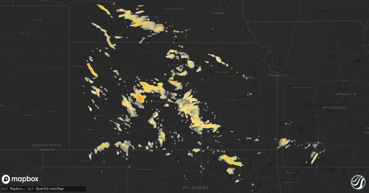
Hail Map in Kansas on May 30, 2012
Get this storm
May 30 map
$229
one time, instant access
Download today. No call, no setup
Keep the $229
Bought the map and want the full workflow? Apply the entire $229 to a subscription within 7 days. None of it is wasted.
Every map, not just this one
This buys you this map. Subscription and you get every map we run, in the markets you choose from a few cities to whole states to nationwide. Plus real-time alerts the moment a storm fires.
Contact data
Name, contact info, occupancy, even credit band for addresses in the footprint. You go from where it hit to who to call.
Become the source they trust
Unlimited branding weather history reports on demand. You already have the documented answer ready for the property owner, and you are the one who showed up with it.
Property data and RoofTrace estimates
Pull up any address you have got, its value and the exact code rules for that jurisdiction, straight from One Click Code. Then RoofTrace estimates the squares, pitch, and roof value, priced the way you price.
Storm reports in Kansas
Kansas
| Date | Description |
|---|---|
| 05/30/20126:59 PM CDT | A local report indicates 1.00 inch wind near 6 S EL DORADO |
| 05/30/20126:59 PM CDT | Trained spotter reported 50 to 60 mph winds in nickerson. |
| 05/30/20126:55 PM CDT | 6 to 7 inch tree limbs downed in the city |
| 05/30/20126:53 PM CDT | Inch and a half in diameter tree limbs down |
| 05/30/20126:52 PM CDT | Major tree damage throughout city with numerous power poles downed. Power out across city. |
| 05/30/20126:50 PM CDT | A local report indicates 1.00 inch wind near 5 SE ALEXANDER |
| 05/30/20126:47 PM CDT | A local report indicates 1.00 inch wind near 8 N JETMORE |
| 05/30/20126:45 PM CDT | At the emergency operations center. |
| 05/30/20126:44 PM CDT | Small cottonwood limbs up to an inch in diameter down. |
| 05/30/20126:43 PM CDT | A local report indicates 1.75 inch wind near AUGUSTA |
| 05/30/20126:41 PM CDT | A local report indicates 2.50 inch wind near 1 S ALEXANDER |
| 05/30/20126:39 PM CDT | On highway 54. |
| 05/30/20126:38 PM CDT | A local report indicates 1.00 inch wind near 9 N JETMORE |
| 05/30/20126:36 PM CDT | The ground was covered with hail. |
| 05/30/20126:35 PM CDT | Individual reported that hail from pea to golfball size fell for 40 minutes at his location south of inman. |
| 05/30/20126:34 PM CDT | A local report indicates 60 MPH wind near 2 SE WESTMORELAND |
| 05/30/20126:33 PM CDT | A local report indicates 60 MPH wind near 4 WSW WESTMORELAND |
| 05/30/20126:32 PM CDT | A local report indicates 60 MPH wind near 4 E HOISINGTON |
| 05/30/20126:29 PM CDT | A local report indicates 60 MPH wind near 7 SSW WESTMORELAND |
| 05/30/20126:27 PM CDT | A local report indicates 1.75 inch wind near 1 S SCOTT STATE LAKE |
| 05/30/20126:21 PM CDT | A local report indicates 60 MPH wind near 2 WNW OLSBURG |
| 05/30/20126:20 PM CDT | A local report indicates 1.00 inch wind near ANDOVER |
| 05/30/20126:17 PM CDT | Andover road and kellog |
| 05/30/20126:17 PM CDT | A local report indicates 1.75 inch wind near 3 SE EAST WICHITA |
| 05/30/20126:16 PM CDT | Slide was blown off wooden playset and trampoline was wrapped around the neighbors fence. Tree damage also reported in the area |
| 05/30/20126:15 PM CDT | A local report indicates 1.25 inch wind near 6 N MODOC |
| 05/30/20126:15 PM CDT | A local report indicates 60 MPH wind near 1 WSW OLSBURG |
| 05/30/20126:14 PM CDT | A local report indicates 1.75 inch wind near 1 N HUTCHINSON |
| 05/30/20126:10 PM CDT | Near central and rock road. |
| 05/30/20126:10 PM CDT | Spotter reported golf ball size hail 3 miles south of andover on butler road. |
| 05/30/20126:07 PM CDT | Quarter to half dollar sized hail. Minor damage to cars. |
| 05/30/20126:05 PM CDT | A local report indicates 60 MPH wind near 4 NNW RANDOLPH |
| 05/30/20126:03 PM CDT | A local report indicates 2.00 inch wind near 12 SSW NESS CITY |
| 05/30/20126:02 PM CDT | Time estimated by radar |
| 05/30/20126:02 PM CDT | Time estimated by radar |
| 05/30/20126:01 PM CDT | Spotter reported near hillside and east kellogg. |
| 05/30/20126:00 PM CDT | Near douglas and hillside spotter reported 1 1/2 to 2 inches. |
| 05/30/20125:57 PM CDT | A local report indicates 1.75 inch wind near 11 SW NESS CITY |
| 05/30/20125:57 PM CDT | Delayed report. |
| 05/30/20125:55 PM CDT | A local report indicates 1.75 inch wind near 5 S MUNJOR |
| 05/30/20125:53 PM CDT | Douglas and hillside |
| 05/30/20125:50 PM CDT | Mainly pea size but a few were golfball size. |
| 05/30/20125:50 PM CDT | Spotter was near lincoln and hillside |
| 05/30/20125:50 PM CDT | A local report indicates 1.00 inch wind near 5 S MARQUETTE |
| 05/30/20125:50 PM CDT | At greenwich and kellogg. |
| 05/30/20125:46 PM CDT | A local report indicates 1.75 inch wind near 6 SSE ANTONINO |
| 05/30/20125:41 PM CDT | A local report indicates 1.50 inch wind near MCPHERSON |
| 05/30/20125:40 PM CDT | Off duty nws employee. |
| 05/30/20125:39 PM CDT | A local report indicates 2.00 inch wind near MCPHERSON |
| 05/30/20125:36 PM CDT | A local report indicates 1.50 inch wind near 3 NNW DOWNTOWN WICHITA |
| 05/30/20125:36 PM CDT | Off duty nws employee. Hillside and douglas. |
| 05/30/20125:35 PM CDT | 1 inch hail at the eoc downtown |
| 05/30/20125:35 PM CDT | Spotter reported minor damage to vehicles and small plants. The hail lasted for about 2 minutes. |
| 05/30/20125:33 PM CDT | At 13th and west. |
| 05/30/20125:30 PM CDT | Off duty nws employee. Near 21st and maize. |
| 05/30/20125:28 PM CDT | Near 235 and zoo blvd |
| 05/30/20125:25 PM CDT | A local report indicates 1.25 inch wind near 3 W MONUMENT |
| 05/30/20125:24 PM CDT | A local report indicates 2.50 inch wind near 1 E ALEXANDER |
| 05/30/20125:24 PM CDT | A local report indicates 2.00 inch wind near ALEXANDER |
| 05/30/20125:23 PM CDT | A local report indicates 1.00 inch wind near 8 NE ELLSWORTH |
| 05/30/20125:23 PM CDT | A local report indicates 1.00 inch wind near 3 SSW MAIZE |
| 05/30/20125:22 PM CDT | 800 main street downtown. |
| 05/30/20125:21 PM CDT | At maple and west street. |
| 05/30/20125:20 PM CDT | A local report indicates 1.75 inch wind near 10 NNW WINONA |
| 05/30/20125:19 PM CDT | Spotter reported 1 west of cow town |
| 05/30/20125:19 PM CDT | Central and tyler roads. |
| 05/30/20125:19 PM CDT | A local report indicates 1.75 inch wind near 3 W DOWNTOWN WICHITA |
| 05/30/20125:18 PM CDT | Wind estimated 60 to 70 mph. Significant crop damage from wind and hail but no estimated hail size. Time estimated. |
| 05/30/20125:12 PM CDT | A local report indicates 1.50 inch wind near 5 NNE PFEIFER |
| 05/30/20125:12 PM CDT | A local report indicates 1.75 inch wind near 1 S ALEXANDER |
| 05/30/20125:11 PM CDT | Mostly penny to nickle with some golf ball size |
| 05/30/20125:10 PM CDT | 119th and maple st |
| 05/30/20125:09 PM CDT | A local report indicates 1.00 inch wind near 2 WSW WEST WICHITA |
| 05/30/20125:07 PM CDT | At 135th and central. |
| 05/30/20125:00 PM CDT | A local report indicates 1.00 inch wind near 4 SE ALEXANDER |
| 05/30/20124:59 PM CDT | A local report indicates 1.00 inch wind near 8 SE BEELER |
| 05/30/20124:56 PM CDT | A local report indicates 1.75 inch wind near 1 S GORHAM |
| 05/30/20124:53 PM CDT | A local report indicates 1.00 inch wind near 7 N GLASCO |
| 05/30/20124:50 PM CDT | A local report indicates 1.50 inch wind near 3 NW SUSANK |
| 05/30/20124:50 PM CDT | A local report indicates 65 MPH wind near 7 N GLASCO |
| 05/30/20124:44 PM CDT | A local report indicates 1.00 inch wind near 12 SSE RUSSELL |
| 05/30/20124:44 PM CDT | A local report indicates 1.75 inch wind near 5 NE PFEIFER |
| 05/30/20124:44 PM CDT | A local report indicates 1.00 inch wind near 14 SE LUDELL |
| 05/30/20124:43 PM CDT | A local report indicates 1.00 inch wind near 3 W GARDEN PLAIN |
| 05/30/20124:42 PM CDT | A local report indicates 2.50 inch wind near 5 NE PFEIFER |
| 05/30/20124:40 PM CDT | Mostly quarter sized hail with a few larger stones. |
| 05/30/20124:39 PM CDT | A local report indicates 1.75 inch wind near 5 NE PFEIFER |
| 05/30/20124:37 PM CDT | A local report indicates 1.00 inch wind near 5 SW ALEXANDER |
| 05/30/20124:36 PM CDT | A local report indicates 1.00 inch wind near 3 N BREWSTER |
| 05/30/20124:30 PM CDT | A local report indicates 1.00 inch wind near 11 NNW LEVANT |
| 05/30/20124:29 PM CDT | 50 to 60 mph winds on the north side of beloit. |
| 05/30/20124:28 PM CDT | A local report indicates 1.75 inch wind near 1 W HAYS |
| 05/30/20124:25 PM CDT | A local report indicates 1.00 inch wind near 7 SSW JEWELL |
| 05/30/20124:20 PM CDT | A local report indicates 1.50 inch wind near NNW HAYS |
| 05/30/20124:18 PM CDT | A local report indicates 2.00 inch wind near 5 N ANTONINO |
| 05/30/20124:17 PM CDT | A local report indicates 2.00 inch wind near 5 S SYLVAN GROVE |
| 05/30/20124:14 PM CDT | A local report indicates 1.00 inch wind near MILBERGER |
| 05/30/20124:13 PM CDT | A local report indicates 1.75 inch wind near 4 ESE RUSSELL |
| 05/30/20124:10 PM CDT | Hail covered one half to three quarters of the ground. |
| 05/30/20124:00 PM CDT | Employee reported a small landspout tornado that was on the ground until 320 pm mdt. |
| 05/30/20124:00 PM CDT | A local report indicates 2.00 inch wind near 5 S MUNJOR |
| 05/30/20123:45 PM CDT | A local report indicates 1.25 inch wind near RUSSELL |
| 05/29/20129:35 PM CDT | Three inch diameter tree limbs blown down. Wind driven hail broke out a window on a pickup topper. Hail size unknown. |
| 05/29/20129:13 PM CDT | Law enforcement reported quarter size hail at north west 40th avenue and north west 150th road. |
| 05/29/20129:11 PM CDT | A local report indicates 60 MPH wind near 6 SSE SAWYER |
| 05/29/20129:01 PM CDT | A local report indicates 1.00 inch wind near 9 NW ENGLEWOOD |
| 05/29/20128:51 PM CDT | A local report indicates 70 MPH wind near 1 NE COLDWATER |
| 05/29/20128:50 PM CDT | A local report indicates 60 MPH wind near 2 SE LEON |
| 05/29/20128:39 PM CDT | Fire department reports 1.5 miles of power poles snapped off along 55th street south between maize and tyler. |
| 05/29/20128:35 PM CDT | Measured 63 mph winds on highway 77. |
| 05/29/20128:33 PM CDT | A local report indicates 65 MPH wind near 3 W UDALL |
| 05/29/20128:30 PM CDT | 8 inch diameter tree limbs down and a large sign blown down in rose hill. |
| 05/29/20128:30 PM CDT | There were five power poles down and winds estimated at 70 mph. |
| 05/29/20128:24 PM CDT | A local report indicates 1.00 inch wind near 4 SW ENSIGN |
| 05/29/20128:18 PM CDT | A local report indicates 70 MPH wind near 3 N BENTON |
| 05/29/20128:14 PM CDT | Andover fire department reports winds of 60 to 70 mph. |
| 05/29/20128:14 PM CDT | A local report indicates 70 MPH wind near 1 N ROSE HILL |
| 05/29/20128:13 PM CDT | A local report indicates 74 MPH wind near 6 ENE FORD |
| 05/29/20128:13 PM CDT | A local report indicates 59 MPH wind near SE MCCONNELL AIR FORCE |
| 05/29/20128:13 PM CDT | A local report indicates 65 MPH wind near CLEARWATER |
| 05/29/20128:12 PM CDT | A local report indicates 62 MPH wind near NW NORTHEAST WICHITA |
| 05/29/20128:08 PM CDT | Near wibw studios off of wanamaker road. |
| 05/29/20128:08 PM CDT | Near 45th and k15. |
| 05/29/20128:06 PM CDT | A local report indicates 58 MPH wind near SE MCCONNELL AIR FORCE |
| 05/29/20128:06 PM CDT | Relayed by wibw studios |
| 05/29/20128:03 PM CDT | Off duty national weather service employee reported winds of 60 to 70 mph. |
| 05/29/20128:01 PM CDT | Carport blown into a tree near central and andover road. |
| 05/29/20128:00 PM CDT | A local report indicates 70 MPH wind near 3 S BELLEFONT |
| 05/29/20128:00 PM CDT | A local report indicates 70 MPH wind near 3 E BELLEFONT |
| 05/29/20128:00 PM CDT | A local report indicates 1.00 inch wind near 6 NNW DODGE CITY |
| 05/29/20127:59 PM CDT | Winds were estimated at 60 to 70 mph. |
| 05/29/20127:58 PM CDT | A local report indicates 60 MPH wind near 3 NW WEST WICHITA |
| 05/29/20127:56 PM CDT | A local report indicates 60 MPH wind near 3 WSW PARK CITY |
| 05/29/20127:55 PM CDT | A local report indicates 1.00 inch wind near BENTON |
| 05/29/20127:52 PM CDT | A local report indicates 60 MPH wind near VALLEY CENTER |
| 05/29/20127:52 PM CDT | A framed building under construction was blown completely to the ground. Time estimated based on reports and radar. |
| 05/29/20127:51 PM CDT | A local report indicates 70 MPH wind near ELBING |
| 05/29/20127:50 PM CDT | Off duty nws employee reported. |
| 05/29/20127:45 PM CDT | Gusts estimated up to 60 mph |
| 05/29/20127:44 PM CDT | Numerous tree limbs down in sedgwick |
| 05/29/20127:40 PM CDT | Power outage in the city of cheney. |
| 05/29/20127:38 PM CDT | Also reporting 60 mph winds. |
| 05/29/20127:38 PM CDT | Also reported golfball sized hail. |
| 05/29/20127:37 PM CDT | A local report indicates 1.00 inch wind near 5 NW HANSTON |
| 05/29/20127:35 PM CDT | Widespread tree and powerline damage was reported in hanston along with a few damaged out buildings in and around town. There were also numerous downed power poles espe |
| 05/29/20127:35 PM CDT | Power lines and trees were downed and roofs were damaged. |
| 05/29/20127:30 PM CDT | A local report indicates 1.75 inch wind near 11 N LAKIN |
| 05/29/20127:28 PM CDT | Numerous limbs down across town in addition to a few trees |
| 05/29/20127:28 PM CDT | Small branches down. |
| 05/29/20127:28 PM CDT | A local report indicates 1.00 inch wind near 1 S NEWTON |
| 05/29/20127:27 PM CDT | 3 inch limbs down. |
| 05/29/20127:25 PM CDT | A local report indicates 1.00 inch wind near LEON |
| 05/29/20127:25 PM CDT | A local report indicates 1.75 inch wind near 6 S NEKOMA |
| 05/29/20127:24 PM CDT | A local report indicates 70 MPH wind near 11 N JETMORE |
| 05/29/20127:24 PM CDT | A local report indicates 1.00 inch wind near 11 N JETMORE |
| 05/29/20127:15 PM CDT | A local report indicates 1.75 inch wind near 11 N LAKIN |
| 05/29/20127:10 PM CDT | Trained spotter reports 7 trees snapped at the base or uprooted with the largest tree being 2 feet at the base. Lots of damage at a trailer park and limbs down in many |
| 05/29/20127:07 PM CDT | A local report indicates 60 MPH wind near 3 N HUTCHINSON |
| 05/29/20127:07 PM CDT | There are reports of power poles and power lines down with power outages in a large portion of hutchinson. |
| 05/29/20127:06 PM CDT | 1 mile north of leon on bluestem road. |
| 05/29/20127:03 PM CDT | A local report indicates 60 MPH wind near BUHLER |
| 05/29/20127:03 PM CDT | Power lines and power poles down. Winds estimated at 60 mph. |
| 05/29/20127:03 PM CDT | Near 23rd and main street at fire station number 2. |
| 05/29/20127:02 PM CDT | On the north side of town. |
All States Impacted by Hail Map on May 30, 2012
Cities Impacted by Hail Map on May 30, 2012
- Wilson, OK
- Braman, OK
- Medford, OK
- Caldwell, KS
- South Haven, KS
- Rozel, KS
- Mobile, AL
- Ryan, OK
- Long Branch, TX
- Gary, TX
- Roe, AR
- Clarendon, AR
- Holly Grove, AR
- Nelson, NE
- Ruskin, NE
- Idabel, OK
- Ballinger, TX
- Norton, TX
- Winters, TX
- Jacksonville, TX
- Wellfleet, NE
- North Platte, NE
- Hershey, NE
- Wynona, OK
- Ramona, OK
- Shidler, OK
- Burbank, OK
- Ochelata, OK
- Barnsdall, OK
- Pawhuska, OK
- Bartlesville, OK
- Juniata, NE
- Victoria, KS
- Colby, KS
- Levant, KS
- Brewster, KS
- Winona, KS
- Paducah, TX
- Pampa, TX
- Maize, KS
- Wichita, KS
- Little Elm, TX
- Lawrence, NE
- Deweese, NE
- Hutchinson, KS
- Humnoke, AR
- Stuttgart, AR
- Ulm, AR
- Carlisle, AR
- De Valls Bluff, AR
- Republic, MO
- Billings, MO
- Collyer, KS
- Delhi, LA
- Newellton, LA
- Winnsboro, LA
- Brookville, KS
- Geneseo, KS
- Bushton, KS
- Lorraine, KS
- Holyrood, KS
- Lyons, KS
- Seymour, TX
- Mcpherson, KS
- Coolidge, TX
- Carterville, MO
- Webb City, MO
- Oronogo, MO
- Jasper, MO
- Joplin, MO
- Alba, MO
- Carthage, MO
- Purcell, MO
- Big Sandy, TX
- Mankato, KS
- Webber, KS
- Ellis, KS
- Scott City, KS
- Leoti, KS
- Electra, TX
- Benton, KS
- Andale, KS
- Colwich, KS
- Mount Hope, KS
- Russell, KS
- Ellsworth, KS
- Lincoln, KS
- Sylvan Grove, KS
- Wilson, KS
- Kanopolis, KS
- Okemah, OK
- Mount Calm, TX
- Axtell, TX
- Mclean, TX
- Chunchula, AL
- Saraland, AL
- Mount Vernon, AL
- Minneapolis, KS
- Miltonvale, KS
- Clay Center, KS
- Watson, AR
- Esbon, KS
- Downs, KS
- Deerfield, KS
- Theodore, AL
- Brownell, KS
- Alexander, KS
- La Crosse, KS
- Nekoma, KS
- Ness City, KS
- Rush Center, KS
- Bazine, KS
- Wellington, KS
- Liberal, KS
- Hugoton, KS
- Strawn, TX
- Coldwater, KS
- Oakley, KS
- Haven, KS
- Atwood, KS
- Oberlin, KS
- Buhler, KS
- Bullard, TX
- Tyler, TX
- Troup, TX
- Flint, TX
- Canton, KS
- Lexington, NE
- Elwood, NE
- Rockwall, TX
- Otis, KS
- Childress, TX
- Quanah, TX
- Crowell, TX
- Wingate, TX
- Tuscola, TX
- Merkel, TX
- Westmoreland, KS
- Minden, NE
- Old Glory, TX
- Medicine Lodge, KS
- Hunter, KS
- Melvin, TX
- Brady, TX
- Gate, OK
- Forgan, OK
- Memphis, TX
- Hawthorne, FL
- Citra, FL
- Fort McCoy, FL
- Holdrege, NE
- Loomis, NE
- Bertrand, NE
- Jetmore, KS
- Barnes, KS
- Waterville, KS
- Randolph, KS
- Greenleaf, KS
- Olsburg, KS
- Blue Rapids, KS
- Millersview, TX
- Burdett, KS
- Simmesport, LA
- Maywood, NE
- Abilene, TX
- Lawn, TX
- Ovalo, TX
- Pratt, KS
- Belpre, KS
- Haviland, KS
- Lewis, KS
- Byers, KS
- Hubbard, TX
- Fort Worth, TX
- Bronte, TX
- Tulsa, OK
- Sapulpa, OK
- Sand Springs, OK
- Aubrey, TX
- Milo, MO
- Nevada, MO
- Gorham, KS
- Liebenthal, KS
- Bison, KS
- Hays, KS
- Schoenchen, KS
- Pfeifer, KS
- Cruger, MS
- Lexington, MS
- Red Rock, OK
- McCracken, KS
- Ransom, KS
- Wright, KS
- Saint Jo, TX
- Nocona, TX
- Wills Point, TX
- Terrell, TX
- Quinlan, TX
- Highlandville, MO
- Ponce De Leon, MO
- Galena, MO
- Ozark, MO
- Spokane, MO
- Reeds Spring, MO
- Eden, TX
- Moss Point, MS
- Upland, NE
- Hildreth, NE
- Campbell, NE
- Larned, KS
- Roanoke, TX
- O'Brien, FL
- McAlpin, FL
- Live Oak, FL
- De Kalb, TX
- Burrton, KS
- Axtell, NE
- Cleburne, TX
- Wagoner, OK
- Vidalia, LA
- Delphos, KS
- Glasco, KS
- Concordia, KS
- Aurora, KS
- Wesson, MS
- Yazoo City, MS
- Reeds, MO
- Sarcoxie, MO
- Talala, OK
- Hooker, OK
- Paint Rock, TX
- Hominy, OK
- Frisco, TX
- Hendley, NE
- Beaver City, NE
- Vicksburg, MS
- Sondheimer, LA
- Valley Park, MS
- Tallulah, LA
- Mayersville, MS
- Sawyer, KS
- Barnard, KS
- Mason, TX
- Tyrone, OK
- Wickes, AR
- Grannis, AR
- Ellinwood, KS
- Hudson, KS
- Loving, TX
- Holcomb, KS
- Royse City, TX
- Tennessee Colony, TX
- Athens, TX
- Montalba, TX
- Palestine, TX
- Streetman, TX
- Fairfield, TX
- Spearville, KS
- Beeler, KS
- Hanston, KS
- Hillsboro, KS
- Eustis, NE
- Geary, OK
- Cimarron, KS
- Inman, KS
- Nickerson, KS
- Moundridge, KS
- Belle Plaine, KS
- Cozad, NE
- Deport, TX
- Indianola, NE
- Lebanon, NE
- McCook, NE
- Culbertson, NE
- Bethany, OK
- Oklahoma City, OK
- Dodge City, KS
- Eight Mile, AL
- Lyndon, KS
- Green, KS
- Morganville, KS
- Guide Rock, NE
- Funk, NE
- Beckville, TX
- Panama City, FL
- Youngstown, FL
- Marienthal, KS
- Voss, TX
- Rowena, TX
- Hext, TX
- Lohn, TX
- Cambridge, KS
- St John, KS
- Macksville, KS
- Sanger, TX
- Valley View, TX
- Pilot Point, TX
- Bogata, TX
- Luray, KS
- Leon, KS
- Blue Hill, NE
- Rosedale, MS
- Park, KS
- Hoxie, KS
- Quinter, KS
- Protection, KS
- Ashland, KS
- Axis, AL
- Sparta, MO
- Seymour, MO
- Butler, AL
- Silver Springs, FL
- Halstead, KS
- Andover, KS
- Derby, KS
- Goddard, KS
- Bentley, KS
- Mcconnell Afb, KS
- Sedgwick, KS
- Augusta, KS
- Valley Center, KS
- Garden Plain, KS
- Rose Hill, KS
- Randall, KS
- Beloit, KS
- Throckmorton, TX
- Frederick, OK
- Soperton, GA
- Rochester, TX
- O'Brien, TX
- Knox City, TX
- Barry, TX
- Purdon, TX
- Silver Lake, KS
- Topeka, KS
- Simms, TX
- Waukomis, OK
- Englewood, KS
- McDonald, KS
- Laneville, TX
- Ensign, KS
- Winfield, KS
- Rock, KS
- Plano, TX
- Richardson, TX
- Homer, LA
- Wauneta, NE
- Hayes Center, NE
- Palisade, NE
- Monument, KS
- Hastings, OK
- Temple, OK
- Randlett, OK
- Walters, OK
- Waurika, OK
- Byers, TX
- Chipley, FL
- Olney, TX
- Lakeview, TX
- Munday, TX
- Goree, TX
- Holliday, TX
- Newcastle, TX
- Tell, TX
- Tichnor, AR
- Florence, MS
- Partridge, KS
- Harper, KS
- Spivey, KS
- Frankston, TX
- Windom, KS
- Sterling, KS
- Douglass, KS
- El Dorado, KS
- Peck, KS
- Hesston, KS
- Galva, KS
- Little River, KS
- Haysville, KS
- Clearwater, KS
- Towanda, KS
- Atlanta, KS
- Newton, KS
- Natchez, MS
- Jacksboro, TX
- Bryson, TX
- Mingus, TX
- Great Bend, KS
- Roxie, MS
- Burr Oak, KS
- Gothenburg, NE
- Avery, TX
- Annona, TX
- Wallace, KS
- Chickasha, OK
- Marquette, KS
- Frisco City, AL
- Waco, TX
- Elm Mott, TX
- Gaylord, KS
- Belzoni, MS
- Brookhaven, MS
- Iuka, KS
- Clarksville, TX
- Meade, KS
- Viola, KS
- Cheney, KS
- Superior, NE
- Branson, MO
- Larue, TX
- Selden, KS
- Jewell, KS
- Olmitz, KS
- Bunker Hill, KS
- Hoisington, KS
- Haworth, OK
- Broken Bow, OK
- Garvin, OK
- Montezuma, KS
- Milford, TX
- Frost, TX
- Italy, TX
- Henderson, TX
- Stamford, TX
- Brady, NE
- Prue, OK
- Skiatook, OK
- Osage, OK
- Wichita Falls, TX
- Defuniak Springs, FL
- Clarendon, TX
- Hedley, TX
- Almyra, AR
- Rose Bud, AR
- Quitman, AR
- Weir, KS
- Fowler, KS
- Gilbertown, AL
- Needham, AL
- Toxey, AL
- Carl Junction, MO
- Golden City, MO
- Galena, KS
- Neck City, MO
- Tryon, NE
- Henrietta, TX
- Haskell, TX
- Holbrook, NE
- Smithfield, NE
- Overton, NE
- De Witt, AR
- Bogue Chitto, MS
- Lindsborg, KS
- Falun, KS
- Franklin, NE
- Robertsdale, AL
- Hennessey, OK
- Price, TX
- Diamond, MO
- Searcy, AR
- Blooming Grove, TX
- Abilene, KS
- Solomon, KS
- Anthony, FL
- Ocala, FL
- Franklin, AR
- Violet Hill, AR
- Newkirk, OK
- La Russell, MO
- Miller, MO
- Perry, OK
- Colony, OK
- Hydro, OK
- Corn, OK
- Chattahoochee, FL
- Quincy, FL
- Weinert, TX
- Rule, TX
- Wilcox, NE
- Bladen, NE
- Elm Creek, NE
- Farnam, NE
- Holstein, NE
- Talco, TX
- Mount Pleasant, TX
- Rowlett, TX
- Forsyth, MO
- Fort Cobb, OK
- Gracemont, OK
- Hamburg, AR
- Claflin, KS
- Wilmer, AL
- Semmes, AL
- Valentine, NE
- Corsicana, TX
- Thedford, NE
- Ingalls, KS
- Sunset, TX
- Stotts City, MO
- Edgewood, TX
- Fruitvale, TX
- Bellevue, TX
- Bowie, TX
- Inglis, FL
- Hazen, AR
- Zenda, KS
- Gilmer, TX
- Walnut Shade, MO
- Rosston, OK
- Swifton, AR
- Tuckerman, AR
- Saffell, AR
- Cord, AR
- Elk City, KS
- Davenport, NE
- Alva, OK
- Freedom, OK
- Roseland, NE
- Wellington, TX
- Lakin, KS
- Jamestown, KS
- Tallahassee, FL
- Alachua, FL
- Lake Butler, FL
- Caddo, TX
- Freeport, FL
- Wylie, TX
- Stapleton, NE
- Minneola, KS
- Hardtner, KS
- Kiowa, KS
- Winfield, TX
- Mount Vernon, TX
- Sweetwater, TX
- Rio Vista, TX
- Grandview, TX
- Sopchoppy, FL
- Panacea, FL
- Chestnutridge, MO
- Bloomington, NE
- Naponee, NE
- Shattuck, OK
- Tonkawa, OK
- Wilmore, KS
- Lindale, TX
- Newhebron, MS
- Sulphur Bluff, TX
- Stephenville, TX
- Perryton, TX
- Garland, TX
- Kismet, KS
- Plains, KS
- Shickley, NE
- Rogersville, MO
- Springfield, MO
- Omaha, TX
- Naples, TX
- Kearney, NE
- Shamrock, TX
- Rolling Fork, MS
- Burlington, OK
- Lucedale, MS
- Hooks, TX
- Nolan, TX
- Alvarado, TX
- Mansfield, TX
- Lillian, TX
- Burleson, TX
- Assaria, KS
- Gypsum, KS
- Burden, KS
- Welch, OK
- Graford, TX
- Shell Knob, MO
- Glenvil, NE
- Ayr, NE
- Itasca, TX
- Oak, NE
- Doole, TX
- Thomasville, AL
- Charleston, MS
- Gordon, TX
- Overton, TX
- Attica, KS
- Ashdown, AR
- Whitesboro, TX
- Collinsville, TX
- Weatherford, OK
- Mullen, NE
- Lake Creek, TX
- Detroit, TX
- Lake City, KS
- Minco, OK
- Pocasset, OK
- New Boston, TX
- Linn, KS
- Talpa, TX
- Benoit, MS
- Itta Bena, MS
- Ringling, OK
- Cordell, OK
- Gotebo, OK
- Calumet, OK
- Cawker City, KS
- Belvue, KS
- Wamego, KS
- Glen Allan, MS
- Cherryvale, KS
- Independence, KS
- Curtis, NE
- Daytona Beach, FL
- Ormond Beach, FL
- Chandler, TX
- Lookeba, OK
- Lamont, OK
- De Witt, NE
- Chase, KS
- Atlanta, NE
- Willow Island, NE
- Odessa, NE
- Howe, TX
- Bunnell, FL
- Palm Coast, FL
- Conway Springs, KS
- Quenemo, KS
- Sweet Water, AL
- Mineral Wells, TX
- Chattanooga, OK
- Simpson, KS
- Leland, MS
- Dorrance, KS
- Lucas, KS
- Carthage, TX
- Matador, TX
- Healy, KS
- Grinnell, KS
- Ford, KS
- Canute, OK
- Atlanta, TX
- The Colony, TX
- Lewisville, TX
- Carrollton, TX
- Carnegie, OK
- Mount Vernon, MO
- Indianola, MS
- Sperry, OK
- Loup City, NE
- Greenville, MS
- Addison, TX
- Dallas, TX
- Utica, MS
- Hazlehurst, MS
- Shaw, MS
- Byram, MS
- Balko, OK
- Haynesville, LA
- Burns, KS
- Forestburg, TX
- Inverness, MS
- Moorhead, MS
- Isola, MS
- Denton, TX
- Ponder, TX
- Edgar, NE
- Terlton, OK
- Citronelle, AL
- Vinegar Bend, AL
- Muenster, TX
- Gainesville, TX
- Elberta, AL
- Lake Dallas, TX
- Joshua, TX
- Walton, KS
- Ponca City, OK
- Ardmore, OK
- Marietta, OK
- Turpin, OK
- Pretty Prairie, KS
- Utica, KS
- Keene, TX
- Godley, TX
- Lampe, MO
- Kimberling City, MO
- Devol, OK
- Livingston, AL
- York, AL
- Azle, TX
- Coats, KS
- Brookline, MO
- Nixa, MO
- Moreauville, LA
- Leonardville, KS
- Herndon, KS
- Mertens, TX
- Era, TX
- Sumner, NE
- Strafford, MO
- Maypearl, TX
- Kennedale, TX
- Arlington, TX
- Venus, TX
- Marion, KS
- Crescent City, FL
- Pomona Park, FL
- Billings, OK
- Mound Valley, KS
- Parsons, KS
- Dennis, KS
- Altamont, KS
- Texarkana, TX
- Terral, OK
- South Hutchinson, KS
- Georgetown, MS
- Blackwell, TX
- Laverne, OK
- Glen Elder, KS
- Altoona, FL
- Abbyville, KS
- Mulvane, KS
- Kechi, KS
- Marvell, AR
- Porter, OK
- Altus, OK
- Nashville, KS
- Argyle, TX
- Waldron, KS
- Terry, MS
- Justin, TX
- El Dorado Springs, MO
- Peabody, KS
- Loveland, OK
- Phillipsburg, KS
- Pensacola, FL
- Bagwell, TX
- Anadarko, OK
- Montague, TX
- Courtland, KS
- Norway, KS
- El Reno, OK
- Rush Springs, OK
- Gillett, AR
- Republican City, NE
- Chadwick, MO
- Geuda Springs, KS
- Arkansas City, KS
- Dexter, KS
- Cedar Vale, KS
- Ocklawaha, FL
- Sun City, KS
- Wisner, LA
- Rhome, TX
- Newark, TX
- Oldfield, MO
- Kinsley, KS
- Miller, NE
- Saint Marys, KS
- Marionville, MO
- Grainfield, KS
- Orleans, NE
- Alma, NE
- Stamford, NE
- Long Island, KS
- Boyle, MS
- Elk City, OK
- Decatur, TX
- Lake City, FL
- Amherst, NE
- Benton, MS
- Paradise, TX
- Howard, KS
- Hollandale, MS
- Chatham, MS
- Jet, OK
- Salina, KS
- Mart, TX
- Edson, KS
- Prosper, TX
- Yukon, OK


