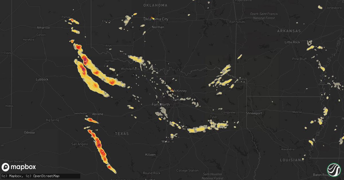
Hail Map on May 30, 2012
Get this storm
May 30 map
$229
one time, instant access
Download today. No call, no setup
Keep the $229
Bought the map and want the full workflow? Apply the entire $229 to a subscription within 7 days. None of it is wasted.
Every map, not just this one
This buys you this map. Subscription and you get every map we run, in the markets you choose from a few cities to whole states to nationwide. Plus real-time alerts the moment a storm fires.
Contact data
Name, contact info, occupancy, even credit band for addresses in the footprint. You go from where it hit to who to call.
Become the source they trust
Unlimited branding weather history reports on demand. You already have the documented answer ready for the property owner, and you are the one who showed up with it.
Property data and RoofTrace estimates
Pull up any address you have got, its value and the exact code rules for that jurisdiction, straight from One Click Code. Then RoofTrace estimates the squares, pitch, and roof value, priced the way you price.
States Impacted by Hail Map on May 30, 2012
Storm reports
Nebraska
| Date | Description |
|---|---|
| 05/30/20125:43 PM CDT | A local report indicates 1.00 inch wind near 4 E CULBERTSON |
| 05/30/20124:58 PM CDT | Considerable damage done to a new convertible from the hail. |
| 05/30/20124:57 PM CDT | A local report indicates 1.00 inch wind near 6 S HAYES CENTER |
| 05/30/20124:55 PM CDT | A local report indicates 1.75 inch wind near 17 SSW NORTH PLATTE |
| 05/30/20124:50 PM CDT | A local report indicates 1.00 inch wind near 3 S HAYES CENTER |
| 05/30/20122:52 PM CDT | A local report indicates 1.00 inch wind near 7 NNW HOLDREGE |
| 05/30/20122:30 PM CDT | A local report indicates 1.00 inch wind near 2 NE DAVENPORT |
| 05/30/20122:26 PM CDT | A local report indicates 1.75 inch wind near BERTRAND |
| 05/30/20121:35 PM CDT | A local report indicates 1.00 inch wind near HOLDREGE |
| 05/30/201212:38 PM CDT | A local report indicates 1.00 inch wind near 3 S LEXINGTON |
| 05/30/201212:27 PM CDT | Water covering the road as well. |
| 05/30/201212:27 PM CDT | Report came from nssl shave program |
| 05/30/201211:43 AM CDT | A local report indicates 1.75 inch wind near 2 SE COZAD |
| 05/30/201211:41 AM CDT | A local report indicates 1.25 inch wind near 1 E COZAD |
| 05/30/201211:39 AM CDT | A local report indicates 1.00 inch wind near 1 E COZAD |
| 05/30/201211:25 AM CDT | Winds from the south |
| 05/30/201211:24 AM CDT | A local report indicates 1.00 inch wind near 5 WNW LEXINGTON AIRPORT |
| 05/30/201210:58 AM CDT | A local report indicates 1.00 inch wind near COZAD |
| 05/30/201210:54 AM CDT | A local report indicates 1.00 inch wind near 3 S WILLOW ISLAND |
| 05/30/201210:54 AM CDT | Hail beginning to cover the ground. |
| 05/30/201210:49 AM CDT | Very heavy rainfall also reported. |
| 05/30/201210:39 AM CDT | Heavy rainfall associated with this storm. |
| 05/30/201210:32 AM CDT | 55 to 60 mph winds from the south. |
| 05/30/201210:17 AM CDT | A local report indicates 1.00 inch wind near JOHNSON LAKE |
| 05/30/201210:12 AM CDT | Quarter size hail covered the ground. |
North Carolina
| Date | Description |
|---|---|
| 05/30/20129:43 AM CDT | Possible tornado just southwest of peletier near little kinston road and morse road. Multiple homes possibly damaged. |
| 05/30/20129:34 AM CDT | Confirmed ef1 tornado with winds of 110 mph located 1.5 miles west of peletier near little kinston road and buster road. Approximately 67 homes were damages and 3 modul |
Oklahoma
| Date | Description |
|---|---|
| 05/30/20127:00 AM CDT | Time estimated |
| 05/30/201212:50 AM CDT | Large tree limbs down |
| 05/30/201212:41 AM CDT | A local report indicates 61 MPH wind near SPERRY |
| 05/30/201212:35 AM CDT | Tree down near 61st and trenton. |
| 05/30/201212:00 AM CDT | A local report indicates 74 MPH wind near 2 NNW NINNEKAH |
| 05/29/201211:55 PM CDT | Trees and power lines down on west side of hominy |
| 05/29/201211:55 PM CDT | Several large limbs down. |
| 05/29/201211:54 PM CDT | A local report indicates 59 MPH wind near WILL ROGERS AIRPORT |
| 05/29/201211:50 PM CDT | Large dumpster blown over and moved about 1/2 block. |
| 05/29/201211:49 PM CDT | A local report indicates 65 MPH wind near YUKON |
| 05/29/201211:40 PM CDT | Estimated 60 mph wind gust and quarter size hail. Relayed through media. |
| 05/29/201211:40 PM CDT | A local report indicates 68 MPH wind near 2 SSW MINCO |
| 05/29/201211:32 PM CDT | Large tree down over road |
| 05/29/201211:30 PM CDT | Large tree down over road |
| 05/29/201211:25 PM CDT | A local report indicates 61 MPH wind near 5 WNW EL RENO |
| 05/29/201211:10 PM CDT | A local report indicates 65 MPH wind near 4 WSW WEATHERFORD |
| 05/29/201211:05 PM CDT | Spotter reported thunderstorm wind gust to 60 mph. Branches downed by winds. |
| 05/29/201211:03 PM CDT | Media estimated 60 mph winds near pershing. |
| 05/29/201211:00 PM CDT | A local report indicates 60 MPH wind near 12 W OKARCHE |
| 05/29/201210:55 PM CDT | A local report indicates 59 MPH wind near VANCE AIR FORCE BASE |
| 05/29/201210:53 PM CDT | A local report indicates 64 MPH wind near 4 SSW SPRINGER |
| 05/29/201210:51 PM CDT | A local report indicates 60 MPH wind near 4 SSW SPRINGER |
| 05/29/201210:40 PM CDT | A local report indicates 58 MPH wind near 3 N PUTNAM |
| 05/29/201210:07 PM CDT | Power poles blown down. Reported by harper county emergency mgt. |
| 05/29/20129:47 PM CDT | A local report indicates 60 MPH wind near NEWKIRK |
| 05/29/20129:45 PM CDT | A local report indicates 62 MPH wind near 2 S ALVA |
| 05/29/20129:45 PM CDT | A local report indicates 63 MPH wind near 7 SSW ALVA |
| 05/29/20129:35 PM CDT | A local report indicates 60 MPH wind near 1 SW BUFFALO |
| 05/29/20129:30 PM CDT | Widespread damage across the town. Up to three foot diameter tree limbs downed. Most of the town without electricity. Reported by alfalfa county emergmgr. |
| 05/29/20129:30 PM CDT | A local report indicates 65 MPH wind near 1 SW BUFFALO |
| 05/29/20128:58 PM CDT | A local report indicates 60 MPH wind near 6 NNW COURTNEY |
| 05/29/20128:12 PM CDT | A local report indicates 1.00 inch wind near 6 NW KNOWLES |
| 05/29/20128:00 PM CDT | A local report indicates 60 MPH wind near 4 ENE WAURIKA |
| 05/29/20127:15 PM CDT | A local report indicates 60 MPH wind near COOKIETOWN |
| 05/29/20127:02 PM CDT | A local report indicates 1.50 inch wind near 2 N GEARY |
| 05/29/20127:00 PM CDT | Dime to quarter hail covering ground |
Kansas
| Date | Description |
|---|---|
| 05/30/20126:59 PM CDT | A local report indicates 1.00 inch wind near 6 S EL DORADO |
| 05/30/20126:59 PM CDT | Trained spotter reported 50 to 60 mph winds in nickerson. |
| 05/30/20126:55 PM CDT | 6 to 7 inch tree limbs downed in the city |
| 05/30/20126:53 PM CDT | Inch and a half in diameter tree limbs down |
| 05/30/20126:52 PM CDT | Major tree damage throughout city with numerous power poles downed. Power out across city. |
| 05/30/20126:50 PM CDT | A local report indicates 1.00 inch wind near 5 SE ALEXANDER |
| 05/30/20126:47 PM CDT | A local report indicates 1.00 inch wind near 8 N JETMORE |
| 05/30/20126:45 PM CDT | At the emergency operations center. |
| 05/30/20126:44 PM CDT | Small cottonwood limbs up to an inch in diameter down. |
| 05/30/20126:43 PM CDT | A local report indicates 1.75 inch wind near AUGUSTA |
| 05/30/20126:41 PM CDT | A local report indicates 2.50 inch wind near 1 S ALEXANDER |
| 05/30/20126:39 PM CDT | On highway 54. |
| 05/30/20126:38 PM CDT | A local report indicates 1.00 inch wind near 9 N JETMORE |
| 05/30/20126:36 PM CDT | The ground was covered with hail. |
| 05/30/20126:35 PM CDT | Individual reported that hail from pea to golfball size fell for 40 minutes at his location south of inman. |
| 05/30/20126:34 PM CDT | A local report indicates 60 MPH wind near 2 SE WESTMORELAND |
| 05/30/20126:33 PM CDT | A local report indicates 60 MPH wind near 4 WSW WESTMORELAND |
| 05/30/20126:32 PM CDT | A local report indicates 60 MPH wind near 4 E HOISINGTON |
| 05/30/20126:29 PM CDT | A local report indicates 60 MPH wind near 7 SSW WESTMORELAND |
| 05/30/20126:27 PM CDT | A local report indicates 1.75 inch wind near 1 S SCOTT STATE LAKE |
| 05/30/20126:21 PM CDT | A local report indicates 60 MPH wind near 2 WNW OLSBURG |
| 05/30/20126:20 PM CDT | A local report indicates 1.00 inch wind near ANDOVER |
| 05/30/20126:17 PM CDT | Andover road and kellog |
| 05/30/20126:17 PM CDT | A local report indicates 1.75 inch wind near 3 SE EAST WICHITA |
| 05/30/20126:16 PM CDT | Slide was blown off wooden playset and trampoline was wrapped around the neighbors fence. Tree damage also reported in the area |
| 05/30/20126:15 PM CDT | A local report indicates 60 MPH wind near 1 WSW OLSBURG |
| 05/30/20126:15 PM CDT | A local report indicates 1.25 inch wind near 6 N MODOC |
| 05/30/20126:14 PM CDT | A local report indicates 1.75 inch wind near 1 N HUTCHINSON |
| 05/30/20126:10 PM CDT | Near central and rock road. |
| 05/30/20126:10 PM CDT | Spotter reported golf ball size hail 3 miles south of andover on butler road. |
| 05/30/20126:07 PM CDT | Quarter to half dollar sized hail. Minor damage to cars. |
| 05/30/20126:05 PM CDT | A local report indicates 60 MPH wind near 4 NNW RANDOLPH |
| 05/30/20126:03 PM CDT | A local report indicates 2.00 inch wind near 12 SSW NESS CITY |
| 05/30/20126:02 PM CDT | Time estimated by radar |
| 05/30/20126:02 PM CDT | Time estimated by radar |
| 05/30/20126:01 PM CDT | Spotter reported near hillside and east kellogg. |
| 05/30/20126:00 PM CDT | Near douglas and hillside spotter reported 1 1/2 to 2 inches. |
| 05/30/20125:57 PM CDT | Delayed report. |
| 05/30/20125:57 PM CDT | A local report indicates 1.75 inch wind near 11 SW NESS CITY |
| 05/30/20125:55 PM CDT | A local report indicates 1.75 inch wind near 5 S MUNJOR |
| 05/30/20125:53 PM CDT | Douglas and hillside |
| 05/30/20125:50 PM CDT | Spotter was near lincoln and hillside |
| 05/30/20125:50 PM CDT | At greenwich and kellogg. |
| 05/30/20125:50 PM CDT | A local report indicates 1.00 inch wind near 5 S MARQUETTE |
| 05/30/20125:50 PM CDT | Mainly pea size but a few were golfball size. |
| 05/30/20125:46 PM CDT | A local report indicates 1.75 inch wind near 6 SSE ANTONINO |
| 05/30/20125:41 PM CDT | A local report indicates 1.50 inch wind near MCPHERSON |
| 05/30/20125:40 PM CDT | Off duty nws employee. |
| 05/30/20125:39 PM CDT | A local report indicates 2.00 inch wind near MCPHERSON |
| 05/30/20125:36 PM CDT | A local report indicates 1.50 inch wind near 3 NNW DOWNTOWN WICHITA |
| 05/30/20125:36 PM CDT | Off duty nws employee. Hillside and douglas. |
| 05/30/20125:35 PM CDT | Spotter reported minor damage to vehicles and small plants. The hail lasted for about 2 minutes. |
| 05/30/20125:35 PM CDT | 1 inch hail at the eoc downtown |
| 05/30/20125:33 PM CDT | At 13th and west. |
| 05/30/20125:30 PM CDT | Off duty nws employee. Near 21st and maize. |
| 05/30/20125:28 PM CDT | Near 235 and zoo blvd |
| 05/30/20125:25 PM CDT | A local report indicates 1.25 inch wind near 3 W MONUMENT |
| 05/30/20125:24 PM CDT | A local report indicates 2.50 inch wind near 1 E ALEXANDER |
| 05/30/20125:24 PM CDT | A local report indicates 2.00 inch wind near ALEXANDER |
| 05/30/20125:23 PM CDT | A local report indicates 1.00 inch wind near 8 NE ELLSWORTH |
| 05/30/20125:23 PM CDT | A local report indicates 1.00 inch wind near 3 SSW MAIZE |
| 05/30/20125:22 PM CDT | 800 main street downtown. |
| 05/30/20125:21 PM CDT | At maple and west street. |
| 05/30/20125:20 PM CDT | A local report indicates 1.75 inch wind near 10 NNW WINONA |
| 05/30/20125:19 PM CDT | Central and tyler roads. |
| 05/30/20125:19 PM CDT | Spotter reported 1 west of cow town |
| 05/30/20125:19 PM CDT | A local report indicates 1.75 inch wind near 3 W DOWNTOWN WICHITA |
| 05/30/20125:18 PM CDT | Wind estimated 60 to 70 mph. Significant crop damage from wind and hail but no estimated hail size. Time estimated. |
| 05/30/20125:12 PM CDT | A local report indicates 1.75 inch wind near 1 S ALEXANDER |
| 05/30/20125:12 PM CDT | A local report indicates 1.50 inch wind near 5 NNE PFEIFER |
| 05/30/20125:11 PM CDT | Mostly penny to nickle with some golf ball size |
| 05/30/20125:10 PM CDT | 119th and maple st |
| 05/30/20125:09 PM CDT | A local report indicates 1.00 inch wind near 2 WSW WEST WICHITA |
| 05/30/20125:07 PM CDT | At 135th and central. |
| 05/30/20125:00 PM CDT | A local report indicates 1.00 inch wind near 4 SE ALEXANDER |
| 05/30/20124:59 PM CDT | A local report indicates 1.00 inch wind near 8 SE BEELER |
| 05/30/20124:56 PM CDT | A local report indicates 1.75 inch wind near 1 S GORHAM |
| 05/30/20124:53 PM CDT | A local report indicates 1.00 inch wind near 7 N GLASCO |
| 05/30/20124:50 PM CDT | A local report indicates 1.50 inch wind near 3 NW SUSANK |
| 05/30/20124:50 PM CDT | A local report indicates 65 MPH wind near 7 N GLASCO |
| 05/30/20124:44 PM CDT | A local report indicates 1.00 inch wind near 12 SSE RUSSELL |
| 05/30/20124:44 PM CDT | A local report indicates 1.75 inch wind near 5 NE PFEIFER |
| 05/30/20124:44 PM CDT | A local report indicates 1.00 inch wind near 14 SE LUDELL |
| 05/30/20124:43 PM CDT | A local report indicates 1.00 inch wind near 3 W GARDEN PLAIN |
| 05/30/20124:42 PM CDT | A local report indicates 2.50 inch wind near 5 NE PFEIFER |
| 05/30/20124:40 PM CDT | Mostly quarter sized hail with a few larger stones. |
| 05/30/20124:39 PM CDT | A local report indicates 1.75 inch wind near 5 NE PFEIFER |
| 05/30/20124:37 PM CDT | A local report indicates 1.00 inch wind near 5 SW ALEXANDER |
| 05/30/20124:36 PM CDT | A local report indicates 1.00 inch wind near 3 N BREWSTER |
| 05/30/20124:30 PM CDT | A local report indicates 1.00 inch wind near 11 NNW LEVANT |
| 05/30/20124:29 PM CDT | 50 to 60 mph winds on the north side of beloit. |
| 05/30/20124:28 PM CDT | A local report indicates 1.75 inch wind near 1 W HAYS |
| 05/30/20124:25 PM CDT | A local report indicates 1.00 inch wind near 7 SSW JEWELL |
| 05/30/20124:20 PM CDT | A local report indicates 1.50 inch wind near NNW HAYS |
| 05/30/20124:18 PM CDT | A local report indicates 2.00 inch wind near 5 N ANTONINO |
| 05/30/20124:17 PM CDT | A local report indicates 2.00 inch wind near 5 S SYLVAN GROVE |
| 05/30/20124:14 PM CDT | A local report indicates 1.00 inch wind near MILBERGER |
| 05/30/20124:13 PM CDT | A local report indicates 1.75 inch wind near 4 ESE RUSSELL |
| 05/30/20124:10 PM CDT | Hail covered one half to three quarters of the ground. |
| 05/30/20124:00 PM CDT | A local report indicates 2.00 inch wind near 5 S MUNJOR |
| 05/30/20124:00 PM CDT | Employee reported a small landspout tornado that was on the ground until 320 pm mdt. |
| 05/30/20123:45 PM CDT | A local report indicates 1.25 inch wind near RUSSELL |
| 05/29/20129:35 PM CDT | Three inch diameter tree limbs blown down. Wind driven hail broke out a window on a pickup topper. Hail size unknown. |
| 05/29/20129:13 PM CDT | Law enforcement reported quarter size hail at north west 40th avenue and north west 150th road. |
| 05/29/20129:11 PM CDT | A local report indicates 60 MPH wind near 6 SSE SAWYER |
| 05/29/20129:01 PM CDT | A local report indicates 1.00 inch wind near 9 NW ENGLEWOOD |
| 05/29/20128:51 PM CDT | A local report indicates 70 MPH wind near 1 NE COLDWATER |
| 05/29/20128:50 PM CDT | A local report indicates 60 MPH wind near 2 SE LEON |
| 05/29/20128:39 PM CDT | Fire department reports 1.5 miles of power poles snapped off along 55th street south between maize and tyler. |
| 05/29/20128:35 PM CDT | Measured 63 mph winds on highway 77. |
| 05/29/20128:33 PM CDT | A local report indicates 65 MPH wind near 3 W UDALL |
| 05/29/20128:30 PM CDT | There were five power poles down and winds estimated at 70 mph. |
| 05/29/20128:30 PM CDT | 8 inch diameter tree limbs down and a large sign blown down in rose hill. |
| 05/29/20128:24 PM CDT | A local report indicates 1.00 inch wind near 4 SW ENSIGN |
| 05/29/20128:18 PM CDT | A local report indicates 70 MPH wind near 3 N BENTON |
| 05/29/20128:14 PM CDT | Andover fire department reports winds of 60 to 70 mph. |
| 05/29/20128:14 PM CDT | A local report indicates 70 MPH wind near 1 N ROSE HILL |
| 05/29/20128:13 PM CDT | A local report indicates 65 MPH wind near CLEARWATER |
| 05/29/20128:13 PM CDT | A local report indicates 74 MPH wind near 6 ENE FORD |
| 05/29/20128:13 PM CDT | A local report indicates 59 MPH wind near SE MCCONNELL AIR FORCE |
| 05/29/20128:12 PM CDT | A local report indicates 62 MPH wind near NW NORTHEAST WICHITA |
| 05/29/20128:08 PM CDT | Near 45th and k15. |
| 05/29/20128:08 PM CDT | Near wibw studios off of wanamaker road. |
| 05/29/20128:06 PM CDT | A local report indicates 58 MPH wind near SE MCCONNELL AIR FORCE |
| 05/29/20128:06 PM CDT | Relayed by wibw studios |
| 05/29/20128:03 PM CDT | Off duty national weather service employee reported winds of 60 to 70 mph. |
| 05/29/20128:01 PM CDT | Carport blown into a tree near central and andover road. |
| 05/29/20128:00 PM CDT | A local report indicates 70 MPH wind near 3 E BELLEFONT |
| 05/29/20128:00 PM CDT | A local report indicates 70 MPH wind near 3 S BELLEFONT |
| 05/29/20128:00 PM CDT | A local report indicates 1.00 inch wind near 6 NNW DODGE CITY |
| 05/29/20127:59 PM CDT | Winds were estimated at 60 to 70 mph. |
| 05/29/20127:58 PM CDT | A local report indicates 60 MPH wind near 3 NW WEST WICHITA |
| 05/29/20127:56 PM CDT | A local report indicates 60 MPH wind near 3 WSW PARK CITY |
| 05/29/20127:55 PM CDT | A local report indicates 1.00 inch wind near BENTON |
| 05/29/20127:52 PM CDT | A local report indicates 60 MPH wind near VALLEY CENTER |
| 05/29/20127:52 PM CDT | A framed building under construction was blown completely to the ground. Time estimated based on reports and radar. |
| 05/29/20127:51 PM CDT | A local report indicates 70 MPH wind near ELBING |
| 05/29/20127:50 PM CDT | Off duty nws employee reported. |
| 05/29/20127:45 PM CDT | Gusts estimated up to 60 mph |
| 05/29/20127:44 PM CDT | Numerous tree limbs down in sedgwick |
| 05/29/20127:40 PM CDT | Power outage in the city of cheney. |
| 05/29/20127:38 PM CDT | Also reported golfball sized hail. |
| 05/29/20127:38 PM CDT | Also reporting 60 mph winds. |
| 05/29/20127:37 PM CDT | A local report indicates 1.00 inch wind near 5 NW HANSTON |
| 05/29/20127:35 PM CDT | Power lines and trees were downed and roofs were damaged. |
| 05/29/20127:35 PM CDT | Widespread tree and powerline damage was reported in hanston along with a few damaged out buildings in and around town. There were also numerous downed power poles espe |
| 05/29/20127:30 PM CDT | A local report indicates 1.75 inch wind near 11 N LAKIN |
| 05/29/20127:28 PM CDT | A local report indicates 1.00 inch wind near 1 S NEWTON |
| 05/29/20127:28 PM CDT | Small branches down. |
| 05/29/20127:28 PM CDT | Numerous limbs down across town in addition to a few trees |
| 05/29/20127:27 PM CDT | 3 inch limbs down. |
| 05/29/20127:25 PM CDT | A local report indicates 1.75 inch wind near 6 S NEKOMA |
| 05/29/20127:25 PM CDT | A local report indicates 1.00 inch wind near LEON |
| 05/29/20127:24 PM CDT | A local report indicates 70 MPH wind near 11 N JETMORE |
| 05/29/20127:24 PM CDT | A local report indicates 1.00 inch wind near 11 N JETMORE |
| 05/29/20127:15 PM CDT | A local report indicates 1.75 inch wind near 11 N LAKIN |
| 05/29/20127:10 PM CDT | Trained spotter reports 7 trees snapped at the base or uprooted with the largest tree being 2 feet at the base. Lots of damage at a trailer park and limbs down in many |
| 05/29/20127:07 PM CDT | There are reports of power poles and power lines down with power outages in a large portion of hutchinson. |
| 05/29/20127:07 PM CDT | A local report indicates 60 MPH wind near 3 N HUTCHINSON |
| 05/29/20127:06 PM CDT | 1 mile north of leon on bluestem road. |
| 05/29/20127:03 PM CDT | A local report indicates 60 MPH wind near BUHLER |
| 05/29/20127:03 PM CDT | Near 23rd and main street at fire station number 2. |
| 05/29/20127:03 PM CDT | Power lines and power poles down. Winds estimated at 60 mph. |
| 05/29/20127:02 PM CDT | On the north side of town. |
Florida
| Date | Description |
|---|---|
| 05/30/20124:31 PM CDT | Trees down on powerlines on old kings road in bulow. |
| 05/30/20124:31 PM CDT | 1 inch hail near old jolly bay rd. And 331. Also a funnel cloud was reported and lightning struck a sheriff substation causing fires in the area. |
| 05/30/20124:21 PM CDT | Trees down on powerlines on old kings road in bulow. |
| 05/30/20123:29 PM CDT | Large tree fell on a house on northeast 166th terrace. No injuries were reported. Residents were not home at the time. Numerous trees and powerlines were reported down |
| 05/30/20123:25 PM CDT | Numerous trees and powerlines were reported down along a 1 to 2 mile stretch of county road 314a from the 3700 to 6000 block. |
Texas
| Date | Description |
|---|---|
| 05/30/20126:56 PM CDT | A local report indicates 60 MPH wind near 1 W PAINT ROCK |
| 05/30/20126:50 PM CDT | A local report indicates 70 MPH wind near 3 W TRUSCOTT |
| 05/30/20126:47 PM CDT | Rain wrapped tornado reported approximately 5 miles ene of paint rock on rural road 1929 |
| 05/30/20126:38 PM CDT | Brief tornado along the runnels and concho county line approximately 2 miles east of us 83. |
| 05/30/20126:33 PM CDT | Dime to quarter size hail near lawn |
| 05/30/20126:28 PM CDT | Storm chaser reported a large rain-wrapped tornado. Location is estimated. |
| 05/30/20126:27 PM CDT | A local report indicates 1.75 inch wind near 3 E OVALO |
| 05/30/20126:27 PM CDT | A local report indicates 60 MPH wind near 3 W TRUSCOTT |
| 05/30/20126:25 PM CDT | A local report indicates 1.75 inch wind near TUSCOLA |
| 05/30/20126:10 PM CDT | Pea to quarter size hail in town |
| 05/30/20126:08 PM CDT | A local report indicates 1.75 inch wind near BALLINGER |
| 05/30/20126:05 PM CDT | A local report indicates 2.75 inch wind near BALLINGER |
| 05/30/20126:00 PM CDT | Report relayed through local broadcast media |
| 05/30/20126:00 PM CDT | Golf ball size hail at abilene state park |
| 05/30/20125:59 PM CDT | Reports of full trees uprooted...sheet metal flying through air...possible combination straight line winds and gustnado |
| 05/30/20125:59 PM CDT | Estimated 80-90 mph winds in paducah. Power is out and several reports of trees down. |
| 05/30/20125:58 PM CDT | A local report indicates 1.75 inch wind near 10 S CHILDRESS |
| 05/30/20125:49 PM CDT | A local report indicates 4.50 inch wind near 6 NE PADUCAH |
| 05/30/20125:42 PM CDT | Hail reported at prison southwest of childress |
| 05/30/20125:40 PM CDT | A local report indicates 2.75 inch wind near 7 NE PADUCAH |
| 05/30/20125:31 PM CDT | A local report indicates 1.75 inch wind near 12 W BUFFALO GAP |
| 05/30/20125:30 PM CDT | A local report indicates 2.75 inch wind near 5 NE NORTON |
| 05/30/20125:28 PM CDT | Quarter to baseball size hail at coronado camp at the junction of us 277 and rural road 89 |
| 05/30/20125:27 PM CDT | A local report indicates 4.50 inch wind near 12 N PADUCAH |
| 05/30/20125:22 PM CDT | Quarter size hail along highway 83 north of paducah |
| 05/30/20125:20 PM CDT | Reported on highway 287 near the hall and childress county line |
| 05/30/20125:10 PM CDT | Nickel to quarter size hail falling. |
| 05/30/20124:55 PM CDT | A local report indicates 1.00 inch wind near 16 N MCLEAN |
| 05/30/20124:50 PM CDT | A local report indicates 1.50 inch wind near 18 N HEDLEY |
| 05/30/20124:36 PM CDT | A local report indicates 3.00 inch wind near 5 NNW ESTELLINE |
| 05/30/20124:25 PM CDT | Barns damaged...power lines down...home with roof removed...trailers blown over. No injuries. |
| 05/30/20124:12 PM CDT | A local report indicates 2.75 inch wind near 1 N LEFORS |
| 05/30/20124:01 PM CDT | A local report indicates 1.00 inch wind near 5 S HEDLEY |
| 05/30/20124:00 PM CDT | A local report indicates 2.00 inch wind near 7 S LELIA LAKE |
| 05/30/20124:00 PM CDT | A local report indicates 1.00 inch wind near HEDLEY |
| 05/30/20123:58 PM CDT | A local report indicates 1.75 inch wind near 7 S HEDLEY |
| 05/30/20123:17 PM CDT | Along hwy 380 between crossroads and prosper |
| 05/30/201210:40 AM CDT | Dime to quarter sized hail fell for several minutes at the intersection of hwy 377 and industrial park |
| 05/30/20127:00 AM CDT | Ping pong to golfball size hail reported in and west of cleburne |
| 05/30/201212:15 AM CDT | A local report indicates 1.00 inch wind near ROYSE CITY |
| 05/30/201212:15 AM CDT | A local report indicates 1.25 inch wind near FATE |
| 05/29/201210:20 PM CDT | Large trees downed in mineral wells knocked power out to s.e. Side of town |
| 05/29/201210:00 PM CDT | A local report indicates 2.75 inch wind near 6 WSW MASON |
| 05/29/20129:58 PM CDT | Trained spotter estimates 60 mph winds east of loving near jermyn. |
| 05/29/20129:55 PM CDT | Measured at krph |
| 05/29/20129:47 PM CDT | Near the county line |
| 05/29/20129:47 PM CDT | A local report indicates 60 MPH wind near OLNEY |
| 05/29/20129:44 PM CDT | A local report indicates 1.25 inch wind near WESTOVER |
| 05/29/20129:44 PM CDT | A local report indicates 60 MPH wind near WESTOVER |
| 05/29/20129:43 PM CDT | A local report indicates 1.50 inch wind near 4 SW MASON |
| 05/29/20129:31 PM CDT | A local report indicates 1.00 inch wind near OLNEY |
| 05/29/20129:31 PM CDT | A local report indicates 60 MPH wind near OLNEY |
| 05/29/20129:25 PM CDT | A local report indicates 77 MPH wind near 1 NNW HASKELL |
| 05/29/20129:00 PM CDT | Hail is mostly around the size of quarters with larger stones mixed in. Hail is ongoing. |
| 05/29/20129:00 PM CDT | Golf ball to tennis ball size hail near the intersection of us 190 and ranch road 1311 |
| 05/29/20128:59 PM CDT | A local report indicates 1.00 inch wind near KNOX CITY |
| 05/29/20128:45 PM CDT | Quarter size hail reported along highway 183 near throckmorton and baylor county line. |
| 05/29/20128:45 PM CDT | A local report indicates 2.75 inch wind near 12 SSE SEYMOUR |
| 05/29/20128:32 PM CDT | Corn crops stripped. |
| 05/29/20128:30 PM CDT | Roof damage was sustained at at least one residence near melvin. Damage occurred just east of ranch road 2028 approximately 3 mile south of melvin. |
| 05/29/20128:30 PM CDT | Wind driven baseball size hail produced extensive damage in melvin. East facing windows were all blown in on several residences |
| 05/29/20128:30 PM CDT | Wind driven baseball size hail produced extensive damage in melvin. East facing windows were all blown in on several residences |
| 05/29/20128:19 PM CDT | Located along highway 82 east of the intersection with state highway 222 |
| 05/29/20128:10 PM CDT | A local report indicates 60 MPH wind near BOMARTON |
| 05/29/20128:10 PM CDT | A local report indicates 1.75 inch wind near BOMARTON |
| 05/29/20128:05 PM CDT | Wall cloud observed in addition to golf ball size hail |
| 05/29/20127:55 PM CDT | Also reports of very strong winds but no speed estimate |
| 05/29/20127:46 PM CDT | A local report indicates 58 MPH wind near SHEPPARD AFB |
| 05/29/20127:43 PM CDT | Golfball to baseball size hail falling |
| 05/29/20127:40 PM CDT | A local report indicates 4.50 inch wind near 10 S PADUCAH |
| 05/29/20127:32 PM CDT | A local report indicates 2.75 inch wind near 10 S PADUCAH |
| 05/29/20127:30 PM CDT | Broken skylights and limbs 1-2 inches healthy pecan tree. |
| 05/29/20127:30 PM CDT | West texas mesonet station |
| 05/29/20127:26 PM CDT | A local report indicates 2.75 inch wind near 6 SW PADUCAH |
| 05/29/20127:24 PM CDT | A local report indicates 2.75 inch wind near 3 W TRUSCOTT |
| 05/29/20127:20 PM CDT | A local report indicates 2.75 inch wind near 5 W PADUCAH |
| 05/29/20127:20 PM CDT | Several road signs blown over in the millersview area. |
| 05/29/20127:20 PM CDT | Brief touchdown |
| 05/29/20127:18 PM CDT | Brief tornado developed and dissipated just south of highway 62 |
| 05/29/20127:17 PM CDT | A local report indicates 2.75 inch wind near MILLERSVIEW |
| 05/29/20127:15 PM CDT | West texas mesonet station |
| 05/29/20127:00 PM CDT | Nickel to baseball size hail near the rural road 1929 bridge |
New York
| Date | Description |
|---|---|
| 05/30/20121:02 PM CDT | Trees down across route 191. Also... 0.29 inches of rain in 15 minutes in hancock |
Arkansas
| Date | Description |
|---|---|
| 05/30/201212:30 PM CDT | Large limbs were reported down in holly grove and electricity is out. |
Louisiana
| Date | Description |
|---|---|
| 05/30/20124:35 PM CDT | Reports of a few powerlines down on highway 128 near fort necessity. |
Mississippi
| Date | Description |
|---|---|
| 05/30/20126:15 PM CDT | Trees down around lake lincoln. |
| 05/30/20125:40 PM CDT | Reports of a tree down on logue circle. |
| 05/30/20125:33 PM CDT | A few trees down on church road due to outflow...reported by wtok-tv |
| 05/30/20125:30 PM CDT | Trees down on n washington st and on east ave. |
| 05/30/20125:30 PM CDT | Tree limbs down in newton. |
| 05/30/20125:30 PM CDT | Trees down on n washington st and on east ave. |
| 05/30/20124:45 PM CDT | Powerlines down |
| 05/30/20124:29 PM CDT | Trees and powerlines down...reported by peterson country store |
| 05/30/20124:11 PM CDT | Roofs blown off of a few sheds |
| 05/30/20122:57 PM CDT | A local report indicates 1.00 inch wind near 2 NE TCHULA |
| 05/30/20122:05 PM CDT | A local report indicates 1.00 inch wind near MOORHEAD |
| 05/30/20121:52 PM CDT | Reports of light poles blown down. Also reports of pea size hail and a tree struck by lightning in nearby morehead at ms delta community college. |
| 05/30/20121:32 PM CDT | Power and traffic lights out in city due to down tree limbs on power lines. |
| 05/30/20121:30 PM CDT | Power and traffic lights out in city due to down tree limbs on power lines. |
| 05/30/20121:25 PM CDT | Reports that a tree fell on a house in boyle and a tree was down in cleveland. |
| 05/29/20127:00 PM CDT | 10 to 15 trees down county wide in jasper co. |
Alabama
| Date | Description |
|---|---|
| 05/30/20125:30 PM CDT | Several trees down in the community of boyd. |
| 05/30/20125:07 PM CDT | Monroe county em reported quarter size hail in frisco city. |
| 05/30/20123:20 PM CDT | Half dollar size hail reported on lakeside drive in mobile. |
| 05/30/20123:18 PM CDT | High winds from a thunderstorm downed down a fence...blew patio furnature across the yard and ripped off siding. |
| 05/30/20123:15 PM CDT | Nws employee reported nickel to larger than quarter size hail at residence 8 sw of downtown mobile. |
| 05/30/20123:00 PM CDT | Quarter size hail reported in tillmans corner. |
Cities Impacted by Hail Map on May 30, 2012
- Wilson, OK
- Braman, OK
- Medford, OK
- Caldwell, KS
- South Haven, KS
- Rozel, KS
- Mobile, AL
- Ryan, OK
- Long Branch, TX
- Gary, TX
- Roe, AR
- Clarendon, AR
- Holly Grove, AR
- Nelson, NE
- Ruskin, NE
- Idabel, OK
- Ballinger, TX
- Norton, TX
- Winters, TX
- Jacksonville, TX
- Wellfleet, NE
- North Platte, NE
- Hershey, NE
- Wynona, OK
- Ramona, OK
- Shidler, OK
- Burbank, OK
- Ochelata, OK
- Barnsdall, OK
- Pawhuska, OK
- Bartlesville, OK
- Juniata, NE
- Victoria, KS
- Colby, KS
- Levant, KS
- Brewster, KS
- Winona, KS
- Paducah, TX
- Pampa, TX
- Maize, KS
- Wichita, KS
- Little Elm, TX
- Lawrence, NE
- Deweese, NE
- Hutchinson, KS
- Humnoke, AR
- Stuttgart, AR
- Ulm, AR
- Carlisle, AR
- De Valls Bluff, AR
- Republic, MO
- Billings, MO
- Collyer, KS
- Delhi, LA
- Newellton, LA
- Winnsboro, LA
- Brookville, KS
- Geneseo, KS
- Bushton, KS
- Lorraine, KS
- Holyrood, KS
- Lyons, KS
- Seymour, TX
- Mcpherson, KS
- Coolidge, TX
- Carterville, MO
- Webb City, MO
- Oronogo, MO
- Jasper, MO
- Joplin, MO
- Alba, MO
- Carthage, MO
- Purcell, MO
- Big Sandy, TX
- Mankato, KS
- Webber, KS
- Ellis, KS
- Scott City, KS
- Leoti, KS
- Electra, TX
- Benton, KS
- Andale, KS
- Colwich, KS
- Mount Hope, KS
- Russell, KS
- Ellsworth, KS
- Lincoln, KS
- Sylvan Grove, KS
- Wilson, KS
- Kanopolis, KS
- Okemah, OK
- Mount Calm, TX
- Axtell, TX
- Mclean, TX
- Chunchula, AL
- Saraland, AL
- Mount Vernon, AL
- Minneapolis, KS
- Miltonvale, KS
- Clay Center, KS
- Watson, AR
- Esbon, KS
- Downs, KS
- Deerfield, KS
- Theodore, AL
- Brownell, KS
- Alexander, KS
- La Crosse, KS
- Nekoma, KS
- Ness City, KS
- Rush Center, KS
- Bazine, KS
- Wellington, KS
- Liberal, KS
- Hugoton, KS
- Strawn, TX
- Coldwater, KS
- Oakley, KS
- Haven, KS
- Atwood, KS
- Oberlin, KS
- Buhler, KS
- Bullard, TX
- Tyler, TX
- Troup, TX
- Flint, TX
- Canton, KS
- Lexington, NE
- Elwood, NE
- Rockwall, TX
- Otis, KS
- Childress, TX
- Quanah, TX
- Crowell, TX
- Wingate, TX
- Tuscola, TX
- Merkel, TX
- Westmoreland, KS
- Minden, NE
- Old Glory, TX
- Medicine Lodge, KS
- Hunter, KS
- Melvin, TX
- Brady, TX
- Gate, OK
- Forgan, OK
- Memphis, TX
- Hawthorne, FL
- Citra, FL
- Fort McCoy, FL
- Holdrege, NE
- Loomis, NE
- Bertrand, NE
- Jetmore, KS
- Barnes, KS
- Waterville, KS
- Randolph, KS
- Greenleaf, KS
- Olsburg, KS
- Blue Rapids, KS
- Millersview, TX
- Burdett, KS
- Simmesport, LA
- Maywood, NE
- Abilene, TX
- Lawn, TX
- Ovalo, TX
- Pratt, KS
- Belpre, KS
- Haviland, KS
- Lewis, KS
- Byers, KS
- Hubbard, TX
- Fort Worth, TX
- Bronte, TX
- Tulsa, OK
- Sapulpa, OK
- Sand Springs, OK
- Aubrey, TX
- Milo, MO
- Nevada, MO
- Gorham, KS
- Liebenthal, KS
- Bison, KS
- Hays, KS
- Schoenchen, KS
- Pfeifer, KS
- Cruger, MS
- Lexington, MS
- Red Rock, OK
- McCracken, KS
- Ransom, KS
- Wright, KS
- Saint Jo, TX
- Nocona, TX
- Wills Point, TX
- Terrell, TX
- Quinlan, TX
- Highlandville, MO
- Ponce De Leon, MO
- Galena, MO
- Ozark, MO
- Spokane, MO
- Reeds Spring, MO
- Eden, TX
- Moss Point, MS
- Upland, NE
- Hildreth, NE
- Campbell, NE
- Larned, KS
- Roanoke, TX
- O'Brien, FL
- McAlpin, FL
- Live Oak, FL
- De Kalb, TX
- Burrton, KS
- Axtell, NE
- Cleburne, TX
- Wagoner, OK
- Vidalia, LA
- Delphos, KS
- Glasco, KS
- Concordia, KS
- Aurora, KS
- Wesson, MS
- Yazoo City, MS
- Reeds, MO
- Sarcoxie, MO
- Talala, OK
- Hooker, OK
- Paint Rock, TX
- Hominy, OK
- Frisco, TX
- Hendley, NE
- Beaver City, NE
- Vicksburg, MS
- Sondheimer, LA
- Valley Park, MS
- Tallulah, LA
- Mayersville, MS
- Sawyer, KS
- Barnard, KS
- Mason, TX
- Tyrone, OK
- Wickes, AR
- Grannis, AR
- Ellinwood, KS
- Hudson, KS
- Loving, TX
- Holcomb, KS
- Royse City, TX
- Tennessee Colony, TX
- Athens, TX
- Montalba, TX
- Palestine, TX
- Streetman, TX
- Fairfield, TX
- Spearville, KS
- Beeler, KS
- Hanston, KS
- Hillsboro, KS
- Eustis, NE
- Geary, OK
- Cimarron, KS
- Inman, KS
- Nickerson, KS
- Moundridge, KS
- Belle Plaine, KS
- Cozad, NE
- Deport, TX
- Indianola, NE
- Lebanon, NE
- McCook, NE
- Culbertson, NE
- Bethany, OK
- Oklahoma City, OK
- Dodge City, KS
- Eight Mile, AL
- Lyndon, KS
- Green, KS
- Morganville, KS
- Guide Rock, NE
- Funk, NE
- Beckville, TX
- Panama City, FL
- Youngstown, FL
- Marienthal, KS
- Voss, TX
- Rowena, TX
- Hext, TX
- Lohn, TX
- Cambridge, KS
- St John, KS
- Macksville, KS
- Sanger, TX
- Valley View, TX
- Pilot Point, TX
- Bogata, TX
- Luray, KS
- Leon, KS
- Blue Hill, NE
- Rosedale, MS
- Park, KS
- Hoxie, KS
- Quinter, KS
- Protection, KS
- Ashland, KS
- Axis, AL
- Sparta, MO
- Seymour, MO
- Butler, AL
- Silver Springs, FL
- Halstead, KS
- Andover, KS
- Derby, KS
- Goddard, KS
- Bentley, KS
- Mcconnell Afb, KS
- Sedgwick, KS
- Augusta, KS
- Valley Center, KS
- Garden Plain, KS
- Rose Hill, KS
- Randall, KS
- Beloit, KS
- Throckmorton, TX
- Frederick, OK
- Soperton, GA
- Rochester, TX
- O'Brien, TX
- Knox City, TX
- Barry, TX
- Purdon, TX
- Silver Lake, KS
- Topeka, KS
- Simms, TX
- Waukomis, OK
- Englewood, KS
- McDonald, KS
- Laneville, TX
- Ensign, KS
- Winfield, KS
- Rock, KS
- Plano, TX
- Richardson, TX
- Homer, LA
- Wauneta, NE
- Hayes Center, NE
- Palisade, NE
- Monument, KS
- Hastings, OK
- Temple, OK
- Randlett, OK
- Walters, OK
- Waurika, OK
- Byers, TX
- Chipley, FL
- Olney, TX
- Lakeview, TX
- Munday, TX
- Goree, TX
- Holliday, TX
- Newcastle, TX
- Tell, TX
- Tichnor, AR
- Florence, MS
- Partridge, KS
- Harper, KS
- Spivey, KS
- Frankston, TX
- Windom, KS
- Sterling, KS
- Douglass, KS
- El Dorado, KS
- Peck, KS
- Hesston, KS
- Galva, KS
- Little River, KS
- Haysville, KS
- Clearwater, KS
- Towanda, KS
- Atlanta, KS
- Newton, KS
- Natchez, MS
- Jacksboro, TX
- Bryson, TX
- Mingus, TX
- Great Bend, KS
- Roxie, MS
- Burr Oak, KS
- Gothenburg, NE
- Avery, TX
- Annona, TX
- Wallace, KS
- Chickasha, OK
- Marquette, KS
- Frisco City, AL
- Waco, TX
- Elm Mott, TX
- Gaylord, KS
- Belzoni, MS
- Brookhaven, MS
- Iuka, KS
- Clarksville, TX
- Meade, KS
- Viola, KS
- Cheney, KS
- Superior, NE
- Branson, MO
- Larue, TX
- Selden, KS
- Jewell, KS
- Olmitz, KS
- Bunker Hill, KS
- Hoisington, KS
- Haworth, OK
- Broken Bow, OK
- Garvin, OK
- Montezuma, KS
- Milford, TX
- Frost, TX
- Italy, TX
- Henderson, TX
- Stamford, TX
- Brady, NE
- Prue, OK
- Skiatook, OK
- Osage, OK
- Wichita Falls, TX
- Defuniak Springs, FL
- Clarendon, TX
- Hedley, TX
- Almyra, AR
- Rose Bud, AR
- Quitman, AR
- Weir, KS
- Fowler, KS
- Gilbertown, AL
- Needham, AL
- Toxey, AL
- Carl Junction, MO
- Golden City, MO
- Galena, KS
- Neck City, MO
- Tryon, NE
- Henrietta, TX
- Haskell, TX
- Holbrook, NE
- Smithfield, NE
- Overton, NE
- De Witt, AR
- Bogue Chitto, MS
- Lindsborg, KS
- Falun, KS
- Franklin, NE
- Robertsdale, AL
- Hennessey, OK
- Price, TX
- Diamond, MO
- Searcy, AR
- Blooming Grove, TX
- Abilene, KS
- Solomon, KS
- Anthony, FL
- Ocala, FL
- Franklin, AR
- Violet Hill, AR
- Newkirk, OK
- La Russell, MO
- Miller, MO
- Perry, OK
- Colony, OK
- Hydro, OK
- Corn, OK
- Chattahoochee, FL
- Quincy, FL
- Weinert, TX
- Rule, TX
- Wilcox, NE
- Bladen, NE
- Elm Creek, NE
- Farnam, NE
- Holstein, NE
- Talco, TX
- Mount Pleasant, TX
- Rowlett, TX
- Forsyth, MO
- Fort Cobb, OK
- Gracemont, OK
- Hamburg, AR
- Claflin, KS
- Wilmer, AL
- Semmes, AL
- Valentine, NE
- Corsicana, TX
- Thedford, NE
- Ingalls, KS
- Sunset, TX
- Stotts City, MO
- Edgewood, TX
- Fruitvale, TX
- Bellevue, TX
- Bowie, TX
- Inglis, FL
- Hazen, AR
- Zenda, KS
- Gilmer, TX
- Walnut Shade, MO
- Rosston, OK
- Swifton, AR
- Tuckerman, AR
- Saffell, AR
- Cord, AR
- Elk City, KS
- Davenport, NE
- Alva, OK
- Freedom, OK
- Roseland, NE
- Wellington, TX
- Lakin, KS
- Jamestown, KS
- Tallahassee, FL
- Alachua, FL
- Lake Butler, FL
- Caddo, TX
- Freeport, FL
- Wylie, TX
- Stapleton, NE
- Minneola, KS
- Hardtner, KS
- Kiowa, KS
- Winfield, TX
- Mount Vernon, TX
- Sweetwater, TX
- Rio Vista, TX
- Grandview, TX
- Sopchoppy, FL
- Panacea, FL
- Chestnutridge, MO
- Bloomington, NE
- Naponee, NE
- Shattuck, OK
- Tonkawa, OK
- Wilmore, KS
- Lindale, TX
- Newhebron, MS
- Sulphur Bluff, TX
- Stephenville, TX
- Perryton, TX
- Garland, TX
- Kismet, KS
- Plains, KS
- Shickley, NE
- Rogersville, MO
- Springfield, MO
- Omaha, TX
- Naples, TX
- Kearney, NE
- Shamrock, TX
- Rolling Fork, MS
- Burlington, OK
- Lucedale, MS
- Hooks, TX
- Nolan, TX
- Alvarado, TX
- Mansfield, TX
- Lillian, TX
- Burleson, TX
- Assaria, KS
- Gypsum, KS
- Burden, KS
- Welch, OK
- Graford, TX
- Shell Knob, MO
- Glenvil, NE
- Ayr, NE
- Itasca, TX
- Oak, NE
- Doole, TX
- Thomasville, AL
- Charleston, MS
- Gordon, TX
- Overton, TX
- Attica, KS
- Ashdown, AR
- Whitesboro, TX
- Collinsville, TX
- Weatherford, OK
- Mullen, NE
- Lake Creek, TX
- Detroit, TX
- Lake City, KS
- Minco, OK
- Pocasset, OK
- New Boston, TX
- Linn, KS
- Talpa, TX
- Benoit, MS
- Itta Bena, MS
- Ringling, OK
- Cordell, OK
- Gotebo, OK
- Calumet, OK
- Cawker City, KS
- Belvue, KS
- Wamego, KS
- Glen Allan, MS
- Cherryvale, KS
- Independence, KS
- Curtis, NE
- Daytona Beach, FL
- Ormond Beach, FL
- Chandler, TX
- Lookeba, OK
- Lamont, OK
- De Witt, NE
- Chase, KS
- Atlanta, NE
- Willow Island, NE
- Odessa, NE
- Howe, TX
- Bunnell, FL
- Palm Coast, FL
- Conway Springs, KS
- Quenemo, KS
- Sweet Water, AL
- Mineral Wells, TX
- Chattanooga, OK
- Simpson, KS
- Leland, MS
- Dorrance, KS
- Lucas, KS
- Carthage, TX
- Matador, TX
- Healy, KS
- Grinnell, KS
- Ford, KS
- Canute, OK
- Atlanta, TX
- The Colony, TX
- Lewisville, TX
- Carrollton, TX
- Carnegie, OK
- Mount Vernon, MO
- Indianola, MS
- Sperry, OK
- Loup City, NE
- Greenville, MS
- Addison, TX
- Dallas, TX
- Utica, MS
- Hazlehurst, MS
- Shaw, MS
- Byram, MS
- Balko, OK
- Haynesville, LA
- Burns, KS
- Forestburg, TX
- Inverness, MS
- Moorhead, MS
- Isola, MS
- Denton, TX
- Ponder, TX
- Edgar, NE
- Terlton, OK
- Citronelle, AL
- Vinegar Bend, AL
- Muenster, TX
- Gainesville, TX
- Elberta, AL
- Lake Dallas, TX
- Joshua, TX
- Walton, KS
- Ponca City, OK
- Ardmore, OK
- Marietta, OK
- Turpin, OK
- Pretty Prairie, KS
- Utica, KS
- Keene, TX
- Godley, TX
- Lampe, MO
- Kimberling City, MO
- Devol, OK
- Livingston, AL
- York, AL
- Azle, TX
- Coats, KS
- Brookline, MO
- Nixa, MO
- Moreauville, LA
- Leonardville, KS
- Herndon, KS
- Mertens, TX
- Era, TX
- Sumner, NE
- Strafford, MO
- Maypearl, TX
- Kennedale, TX
- Arlington, TX
- Venus, TX
- Marion, KS
- Crescent City, FL
- Pomona Park, FL
- Billings, OK
- Mound Valley, KS
- Parsons, KS
- Dennis, KS
- Altamont, KS
- Texarkana, TX
- Terral, OK
- South Hutchinson, KS
- Georgetown, MS
- Blackwell, TX
- Laverne, OK
- Glen Elder, KS
- Altoona, FL
- Abbyville, KS
- Mulvane, KS
- Kechi, KS
- Marvell, AR
- Porter, OK
- Altus, OK
- Nashville, KS
- Argyle, TX
- Waldron, KS
- Terry, MS
- Justin, TX
- El Dorado Springs, MO
- Peabody, KS
- Loveland, OK
- Phillipsburg, KS
- Pensacola, FL
- Bagwell, TX
- Anadarko, OK
- Montague, TX
- Courtland, KS
- Norway, KS
- El Reno, OK
- Rush Springs, OK
- Gillett, AR
- Republican City, NE
- Chadwick, MO
- Geuda Springs, KS
- Arkansas City, KS
- Dexter, KS
- Cedar Vale, KS
- Ocklawaha, FL
- Sun City, KS
- Wisner, LA
- Rhome, TX
- Newark, TX
- Oldfield, MO
- Kinsley, KS
- Miller, NE
- Saint Marys, KS
- Marionville, MO
- Grainfield, KS
- Orleans, NE
- Alma, NE
- Stamford, NE
- Long Island, KS
- Boyle, MS
- Elk City, OK
- Decatur, TX
- Lake City, FL
- Amherst, NE
- Benton, MS
- Paradise, TX
- Howard, KS
- Hollandale, MS
- Chatham, MS
- Jet, OK
- Salina, KS
- Mart, TX
- Edson, KS
- Prosper, TX
- Yukon, OK