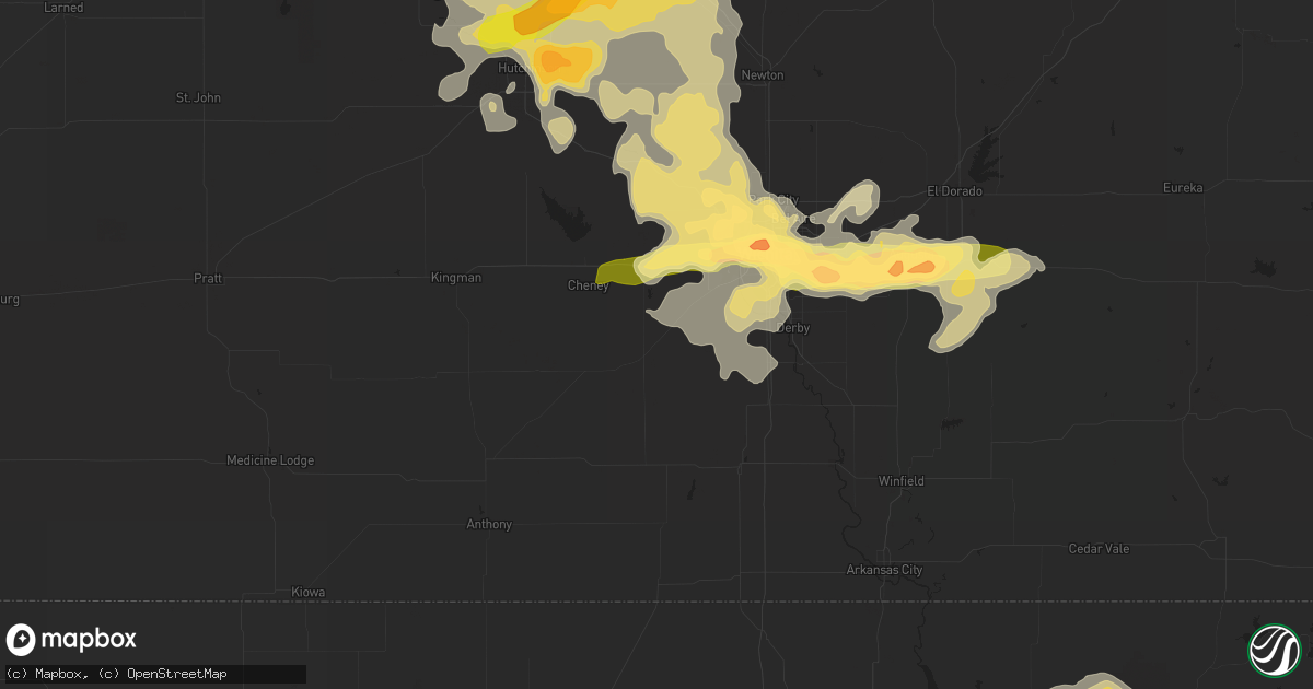
Hail Map in Hutchinson, KS on May 30, 2012
Get this storm
May 30 map
$229
one time, instant access
Download today. No call, no setup
Keep the $229
Bought the map and want the full workflow? Apply the entire $229 to a subscription within 7 days. None of it is wasted.
Every map, not just this one
This buys you this map. Subscription and you get every map we run, in the markets you choose from a few cities to whole states to nationwide. Plus real-time alerts the moment a storm fires.
Contact data
Name, contact info, occupancy, even credit band for addresses in the footprint. You go from where it hit to who to call.
Become the source they trust
Unlimited branding weather history reports on demand. You already have the documented answer ready for the property owner, and you are the one who showed up with it.
Property data and RoofTrace estimates
Pull up any address you have got, its value and the exact code rules for that jurisdiction, straight from One Click Code. Then RoofTrace estimates the squares, pitch, and roof value, priced the way you price.
Storm reports in Hutchinson, KS
Hutchinson, KS
| Date | Description |
|---|---|
| 05/30/20126:14 PM CDT | A local report indicates 1.75 inch wind near 1 N HUTCHINSON |
| 05/29/20127:07 PM CDT | There are reports of power poles and power lines down with power outages in a large portion of hutchinson. |
| 05/29/20127:07 PM CDT | A local report indicates 60 MPH wind near 3 N HUTCHINSON |
| 05/29/20127:03 PM CDT | Near 23rd and main street at fire station number 2. |
| 05/29/20127:03 PM CDT | Power lines and power poles down. Winds estimated at 60 mph. |
| 05/29/20127:02 PM CDT | On the north side of town. |
All States Impacted by Hail Map on May 30, 2012
All Cities Impacted by Hail Map on May 30, 2012
- Wilson, OK
- Braman, OK
- Medford, OK
- Caldwell, KS
- South Haven, KS
- Rozel, KS
- Mobile, AL
- Ryan, OK
- Long Branch, TX
- Gary, TX
- Roe, AR
- Clarendon, AR
- Holly Grove, AR
- Nelson, NE
- Ruskin, NE
- Idabel, OK
- Ballinger, TX
- Norton, TX
- Winters, TX
- Jacksonville, TX
- Wellfleet, NE
- North Platte, NE
- Hershey, NE
- Wynona, OK
- Ramona, OK
- Shidler, OK
- Burbank, OK
- Ochelata, OK
- Barnsdall, OK
- Pawhuska, OK
- Bartlesville, OK
- Juniata, NE
- Victoria, KS
- Colby, KS
- Levant, KS
- Brewster, KS
- Winona, KS
- Paducah, TX
- Pampa, TX
- Maize, KS
- Wichita, KS
- Little Elm, TX
- Lawrence, NE
- Deweese, NE
- Hutchinson, KS
- Humnoke, AR
- Stuttgart, AR
- Ulm, AR
- Carlisle, AR
- De Valls Bluff, AR
- Republic, MO
- Billings, MO
- Collyer, KS
- Delhi, LA
- Newellton, LA
- Winnsboro, LA
- Brookville, KS
- Geneseo, KS
- Bushton, KS
- Lorraine, KS
- Holyrood, KS
- Lyons, KS
- Seymour, TX
- Mcpherson, KS
- Coolidge, TX
- Carterville, MO
- Webb City, MO
- Oronogo, MO
- Jasper, MO
- Joplin, MO
- Alba, MO
- Carthage, MO
- Purcell, MO
- Big Sandy, TX
- Mankato, KS
- Webber, KS
- Ellis, KS
- Scott City, KS
- Leoti, KS
- Electra, TX
- Benton, KS
- Andale, KS
- Colwich, KS
- Mount Hope, KS
- Russell, KS
- Ellsworth, KS
- Lincoln, KS
- Sylvan Grove, KS
- Wilson, KS
- Kanopolis, KS
- Okemah, OK
- Mount Calm, TX
- Axtell, TX
- Mclean, TX
- Chunchula, AL
- Saraland, AL
- Mount Vernon, AL
- Minneapolis, KS
- Miltonvale, KS
- Clay Center, KS
- Watson, AR
- Esbon, KS
- Downs, KS
- Deerfield, KS
- Theodore, AL
- Brownell, KS
- Alexander, KS
- La Crosse, KS
- Nekoma, KS
- Ness City, KS
- Rush Center, KS
- Bazine, KS
- Wellington, KS
- Liberal, KS
- Hugoton, KS
- Strawn, TX
- Coldwater, KS
- Oakley, KS
- Haven, KS
- Atwood, KS
- Oberlin, KS
- Buhler, KS
- Bullard, TX
- Tyler, TX
- Troup, TX
- Flint, TX
- Canton, KS
- Lexington, NE
- Elwood, NE
- Rockwall, TX
- Otis, KS
- Childress, TX
- Quanah, TX
- Crowell, TX
- Wingate, TX
- Tuscola, TX
- Merkel, TX
- Westmoreland, KS
- Minden, NE
- Old Glory, TX
- Medicine Lodge, KS
- Hunter, KS
- Melvin, TX
- Brady, TX
- Gate, OK
- Forgan, OK
- Memphis, TX
- Hawthorne, FL
- Citra, FL
- Fort McCoy, FL
- Holdrege, NE
- Loomis, NE
- Bertrand, NE
- Jetmore, KS
- Barnes, KS
- Waterville, KS
- Randolph, KS
- Greenleaf, KS
- Olsburg, KS
- Blue Rapids, KS
- Millersview, TX
- Burdett, KS
- Simmesport, LA
- Maywood, NE
- Abilene, TX
- Lawn, TX
- Ovalo, TX
- Pratt, KS
- Belpre, KS
- Haviland, KS
- Lewis, KS
- Byers, KS
- Hubbard, TX
- Fort Worth, TX
- Bronte, TX
- Tulsa, OK
- Sapulpa, OK
- Sand Springs, OK
- Aubrey, TX
- Milo, MO
- Nevada, MO
- Gorham, KS
- Liebenthal, KS
- Bison, KS
- Hays, KS
- Schoenchen, KS
- Pfeifer, KS
- Cruger, MS
- Lexington, MS
- Red Rock, OK
- McCracken, KS
- Ransom, KS
- Wright, KS
- Saint Jo, TX
- Nocona, TX
- Wills Point, TX
- Terrell, TX
- Quinlan, TX
- Highlandville, MO
- Ponce De Leon, MO
- Galena, MO
- Ozark, MO
- Spokane, MO
- Reeds Spring, MO
- Eden, TX
- Moss Point, MS
- Upland, NE
- Hildreth, NE
- Campbell, NE
- Larned, KS
- Roanoke, TX
- O'Brien, FL
- McAlpin, FL
- Live Oak, FL
- De Kalb, TX
- Burrton, KS
- Axtell, NE
- Cleburne, TX
- Wagoner, OK
- Vidalia, LA
- Delphos, KS
- Glasco, KS
- Concordia, KS
- Aurora, KS
- Wesson, MS
- Yazoo City, MS
- Reeds, MO
- Sarcoxie, MO
- Talala, OK
- Hooker, OK
- Paint Rock, TX
- Hominy, OK
- Frisco, TX
- Hendley, NE
- Beaver City, NE
- Vicksburg, MS
- Sondheimer, LA
- Valley Park, MS
- Tallulah, LA
- Mayersville, MS
- Sawyer, KS
- Barnard, KS
- Mason, TX
- Tyrone, OK
- Wickes, AR
- Grannis, AR
- Ellinwood, KS
- Hudson, KS
- Loving, TX
- Holcomb, KS
- Royse City, TX
- Tennessee Colony, TX
- Athens, TX
- Montalba, TX
- Palestine, TX
- Streetman, TX
- Fairfield, TX
- Spearville, KS
- Beeler, KS
- Hanston, KS
- Hillsboro, KS
- Eustis, NE
- Geary, OK
- Cimarron, KS
- Inman, KS
- Nickerson, KS
- Moundridge, KS
- Belle Plaine, KS
- Cozad, NE
- Deport, TX
- Indianola, NE
- Lebanon, NE
- McCook, NE
- Culbertson, NE
- Bethany, OK
- Oklahoma City, OK
- Dodge City, KS
- Eight Mile, AL
- Lyndon, KS
- Green, KS
- Morganville, KS
- Guide Rock, NE
- Funk, NE
- Beckville, TX
- Panama City, FL
- Youngstown, FL
- Marienthal, KS
- Voss, TX
- Rowena, TX
- Hext, TX
- Lohn, TX
- Cambridge, KS
- St John, KS
- Macksville, KS
- Sanger, TX
- Valley View, TX
- Pilot Point, TX
- Bogata, TX
- Luray, KS
- Leon, KS
- Blue Hill, NE
- Rosedale, MS
- Park, KS
- Hoxie, KS
- Quinter, KS
- Protection, KS
- Ashland, KS
- Axis, AL
- Sparta, MO
- Seymour, MO
- Butler, AL
- Silver Springs, FL
- Halstead, KS
- Andover, KS
- Derby, KS
- Goddard, KS
- Bentley, KS
- Mcconnell Afb, KS
- Sedgwick, KS
- Augusta, KS
- Valley Center, KS
- Garden Plain, KS
- Rose Hill, KS
- Randall, KS
- Beloit, KS
- Throckmorton, TX
- Frederick, OK
- Soperton, GA
- Rochester, TX
- O'Brien, TX
- Knox City, TX
- Barry, TX
- Purdon, TX
- Silver Lake, KS
- Topeka, KS
- Simms, TX
- Waukomis, OK
- Englewood, KS
- McDonald, KS
- Laneville, TX
- Ensign, KS
- Winfield, KS
- Rock, KS
- Plano, TX
- Richardson, TX
- Homer, LA
- Wauneta, NE
- Hayes Center, NE
- Palisade, NE
- Monument, KS
- Hastings, OK
- Temple, OK
- Randlett, OK
- Walters, OK
- Waurika, OK
- Byers, TX
- Chipley, FL
- Olney, TX
- Lakeview, TX
- Munday, TX
- Goree, TX
- Holliday, TX
- Newcastle, TX
- Tell, TX
- Tichnor, AR
- Florence, MS
- Partridge, KS
- Harper, KS
- Spivey, KS
- Frankston, TX
- Windom, KS
- Sterling, KS
- Douglass, KS
- El Dorado, KS
- Peck, KS
- Hesston, KS
- Galva, KS
- Little River, KS
- Haysville, KS
- Clearwater, KS
- Towanda, KS
- Atlanta, KS
- Newton, KS
- Natchez, MS
- Jacksboro, TX
- Bryson, TX
- Mingus, TX
- Great Bend, KS
- Roxie, MS
- Burr Oak, KS
- Gothenburg, NE
- Avery, TX
- Annona, TX
- Wallace, KS
- Chickasha, OK
- Marquette, KS
- Frisco City, AL
- Waco, TX
- Elm Mott, TX
- Gaylord, KS
- Belzoni, MS
- Brookhaven, MS
- Iuka, KS
- Clarksville, TX
- Meade, KS
- Viola, KS
- Cheney, KS
- Superior, NE
- Branson, MO
- Larue, TX
- Selden, KS
- Jewell, KS
- Olmitz, KS
- Bunker Hill, KS
- Hoisington, KS
- Haworth, OK
- Broken Bow, OK
- Garvin, OK
- Montezuma, KS
- Milford, TX
- Frost, TX
- Italy, TX
- Henderson, TX
- Stamford, TX
- Brady, NE
- Prue, OK
- Skiatook, OK
- Osage, OK
- Wichita Falls, TX
- Defuniak Springs, FL
- Clarendon, TX
- Hedley, TX
- Almyra, AR
- Rose Bud, AR
- Quitman, AR
- Weir, KS
- Fowler, KS
- Gilbertown, AL
- Needham, AL
- Toxey, AL
- Carl Junction, MO
- Golden City, MO
- Galena, KS
- Neck City, MO
- Tryon, NE
- Henrietta, TX
- Haskell, TX
- Holbrook, NE
- Smithfield, NE
- Overton, NE
- De Witt, AR
- Bogue Chitto, MS
- Lindsborg, KS
- Falun, KS
- Franklin, NE
- Robertsdale, AL
- Hennessey, OK
- Price, TX
- Diamond, MO
- Searcy, AR
- Blooming Grove, TX
- Abilene, KS
- Solomon, KS
- Anthony, FL
- Ocala, FL
- Franklin, AR
- Violet Hill, AR
- Newkirk, OK
- La Russell, MO
- Miller, MO
- Perry, OK
- Colony, OK
- Hydro, OK
- Corn, OK
- Chattahoochee, FL
- Quincy, FL
- Weinert, TX
- Rule, TX
- Wilcox, NE
- Bladen, NE
- Elm Creek, NE
- Farnam, NE
- Holstein, NE
- Talco, TX
- Mount Pleasant, TX
- Rowlett, TX
- Forsyth, MO
- Fort Cobb, OK
- Gracemont, OK
- Hamburg, AR
- Claflin, KS
- Wilmer, AL
- Semmes, AL
- Valentine, NE
- Corsicana, TX
- Thedford, NE
- Ingalls, KS
- Sunset, TX
- Stotts City, MO
- Edgewood, TX
- Fruitvale, TX
- Bellevue, TX
- Bowie, TX
- Inglis, FL
- Hazen, AR
- Zenda, KS
- Gilmer, TX
- Walnut Shade, MO
- Rosston, OK
- Swifton, AR
- Tuckerman, AR
- Saffell, AR
- Cord, AR
- Elk City, KS
- Davenport, NE
- Alva, OK
- Freedom, OK
- Roseland, NE
- Wellington, TX
- Lakin, KS
- Jamestown, KS
- Tallahassee, FL
- Alachua, FL
- Lake Butler, FL
- Caddo, TX
- Freeport, FL
- Wylie, TX
- Stapleton, NE
- Minneola, KS
- Hardtner, KS
- Kiowa, KS
- Winfield, TX
- Mount Vernon, TX
- Sweetwater, TX
- Rio Vista, TX
- Grandview, TX
- Sopchoppy, FL
- Panacea, FL
- Chestnutridge, MO
- Bloomington, NE
- Naponee, NE
- Shattuck, OK
- Tonkawa, OK
- Wilmore, KS
- Lindale, TX
- Newhebron, MS
- Sulphur Bluff, TX
- Stephenville, TX
- Perryton, TX
- Garland, TX
- Kismet, KS
- Plains, KS
- Shickley, NE
- Rogersville, MO
- Springfield, MO
- Omaha, TX
- Naples, TX
- Kearney, NE
- Shamrock, TX
- Rolling Fork, MS
- Burlington, OK
- Lucedale, MS
- Hooks, TX
- Nolan, TX
- Alvarado, TX
- Mansfield, TX
- Lillian, TX
- Burleson, TX
- Assaria, KS
- Gypsum, KS
- Burden, KS
- Welch, OK
- Graford, TX
- Shell Knob, MO
- Glenvil, NE
- Ayr, NE
- Itasca, TX
- Oak, NE
- Doole, TX
- Thomasville, AL
- Charleston, MS
- Gordon, TX
- Overton, TX
- Attica, KS
- Ashdown, AR
- Whitesboro, TX
- Collinsville, TX
- Weatherford, OK
- Mullen, NE
- Lake Creek, TX
- Detroit, TX
- Lake City, KS
- Minco, OK
- Pocasset, OK
- New Boston, TX
- Linn, KS
- Talpa, TX
- Benoit, MS
- Itta Bena, MS
- Ringling, OK
- Cordell, OK
- Gotebo, OK
- Calumet, OK
- Cawker City, KS
- Belvue, KS
- Wamego, KS
- Glen Allan, MS
- Cherryvale, KS
- Independence, KS
- Curtis, NE
- Daytona Beach, FL
- Ormond Beach, FL
- Chandler, TX
- Lookeba, OK
- Lamont, OK
- De Witt, NE
- Chase, KS
- Atlanta, NE
- Willow Island, NE
- Odessa, NE
- Howe, TX
- Bunnell, FL
- Palm Coast, FL
- Conway Springs, KS
- Quenemo, KS
- Sweet Water, AL
- Mineral Wells, TX
- Chattanooga, OK
- Simpson, KS
- Leland, MS
- Dorrance, KS
- Lucas, KS
- Carthage, TX
- Matador, TX
- Healy, KS
- Grinnell, KS
- Ford, KS
- Canute, OK
- Atlanta, TX
- The Colony, TX
- Lewisville, TX
- Carrollton, TX
- Carnegie, OK
- Mount Vernon, MO
- Indianola, MS
- Sperry, OK
- Loup City, NE
- Greenville, MS
- Addison, TX
- Dallas, TX
- Utica, MS
- Hazlehurst, MS
- Shaw, MS
- Byram, MS
- Balko, OK
- Haynesville, LA
- Burns, KS
- Forestburg, TX
- Inverness, MS
- Moorhead, MS
- Isola, MS
- Denton, TX
- Ponder, TX
- Edgar, NE
- Terlton, OK
- Citronelle, AL
- Vinegar Bend, AL
- Muenster, TX
- Gainesville, TX
- Elberta, AL
- Lake Dallas, TX
- Joshua, TX
- Walton, KS
- Ponca City, OK
- Ardmore, OK
- Marietta, OK
- Turpin, OK
- Pretty Prairie, KS
- Utica, KS
- Keene, TX
- Godley, TX
- Lampe, MO
- Kimberling City, MO
- Devol, OK
- Livingston, AL
- York, AL
- Azle, TX
- Coats, KS
- Brookline, MO
- Nixa, MO
- Moreauville, LA
- Leonardville, KS
- Herndon, KS
- Mertens, TX
- Era, TX
- Sumner, NE
- Strafford, MO
- Maypearl, TX
- Kennedale, TX
- Arlington, TX
- Venus, TX
- Marion, KS
- Crescent City, FL
- Pomona Park, FL
- Billings, OK
- Mound Valley, KS
- Parsons, KS
- Dennis, KS
- Altamont, KS
- Texarkana, TX
- Terral, OK
- South Hutchinson, KS
- Georgetown, MS
- Blackwell, TX
- Laverne, OK
- Glen Elder, KS
- Altoona, FL
- Abbyville, KS
- Mulvane, KS
- Kechi, KS
- Marvell, AR
- Porter, OK
- Altus, OK
- Nashville, KS
- Argyle, TX
- Waldron, KS
- Terry, MS
- Justin, TX
- El Dorado Springs, MO
- Peabody, KS
- Loveland, OK
- Phillipsburg, KS
- Pensacola, FL
- Bagwell, TX
- Anadarko, OK
- Montague, TX
- Courtland, KS
- Norway, KS
- El Reno, OK
- Rush Springs, OK
- Gillett, AR
- Republican City, NE
- Chadwick, MO
- Geuda Springs, KS
- Arkansas City, KS
- Dexter, KS
- Cedar Vale, KS
- Ocklawaha, FL
- Sun City, KS
- Wisner, LA
- Rhome, TX
- Newark, TX
- Oldfield, MO
- Kinsley, KS
- Miller, NE
- Saint Marys, KS
- Marionville, MO
- Grainfield, KS
- Orleans, NE
- Alma, NE
- Stamford, NE
- Long Island, KS
- Boyle, MS
- Elk City, OK
- Decatur, TX
- Lake City, FL
- Amherst, NE
- Benton, MS
- Paradise, TX
- Howard, KS
- Hollandale, MS
- Chatham, MS
- Jet, OK
- Salina, KS
- Mart, TX
- Edson, KS
- Prosper, TX
- Yukon, OK


