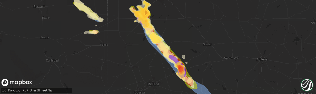
Hail Map in Lamesa, TX on May 29, 2025
The weather event in Lamesa, TX on May 29, 2025 includes Hail, Wind, and Tornado maps. 12 states and 280 cities were impacted and suffered possible damage. The total estimated number of properties impacted is 5,336.
Hail
Wind
Tornado
5,336
Estimated number of impacted properties by a 1.00" hail or larger5,184
Estimated number of impacted properties by a 1.75" hail or larger0
Estimated number of impacted properties by a 2.50" hail or largerStorm reports in Lamesa, TX
Lamesa, TX
| Date | Description |
|---|---|
| 05/29/20256:46 PM CDT | This was the estimated path of a brief tornado in the vicinity of sparenberg to the southeast of lamesa. Irrigation pivots were found lying towards the southeast. This |
| 05/29/20256:34 PM CDT | Mesonet station 18 lamesa 2se. |
| 05/29/20256:32 PM CDT | There were reports of damage to signs... Power poles... And trees in the town of lamesa. Time is estimated from radar. |
| 05/29/20256:32 PM CDT | There were reports of damage to signs... Power poles... And trees in the town of lamesa. Time is estimated from radar. |
| 05/29/20256:22 PM CDT | A metal irrigation spool was thrown 20 yards towards the south-southeast. Spool weighs approximately 200 lbs. Time is estimated from radar. |
All States Impacted by Hail Map on May 29, 2025
All Cities Impacted by Hail Map on May 29, 2025
- Livingston, LA
- Lone Wolf, OK
- Mangum, OK
- Loveland, OK
- Walters, OK
- Chattanooga, OK
- Randlett, OK
- Grandfield, OK
- Blair, OK
- Temple, OK
- Devol, OK
- Byers, TX
- Petrolia, TX
- Ryan, OK
- Henrietta, TX
- Terral, OK
- Mobile, AL
- Semmes, AL
- Ringgold, TX
- Nocona, TX
- Daphne, AL
- Fairhope, AL
- Silverhill, AL
- Loxley, AL
- Robertsdale, AL
- Indiahoma, OK
- Comanche, OK
- Cache, OK
- Duncan, OK
- Faxon, OK
- Waurika, OK
- Yemassee, SC
- Inverness, FL
- Pineville, SC
- Hernando, FL
- Dunnellon, FL
- Savannah, GA
- Lake Panasoffkee, FL
- Georgetown, SC
- Nesmith, SC
- Hemingway, SC
- Hardeeville, SC
- Ocala, FL
- Jackson Springs, NC
- Newington, GA
- Capitan, NM
- Silver Springs, FL
- Orangeburg, SC
- Carthage, NC
- West End, NC
- Pinehurst, NC
- Gaston, SC
- Cloudcroft, NM
- Vass, NC
- Southern Pines, NC
- Eastover, SC
- Gadsden, SC
- Floral City, FL
- Elk City, OK
- Canute, OK
- Ridge Spring, SC
- Alachua, FL
- Cameron, SC
- Palatka, FL
- Bushnell, FL
- Lake Butler, FL
- Van Horn, TX
- Corona, NM
- Interlachen, FL
- Guyton, GA
- Cameron, NC
- Immokalee, FL
- Naples, FL
- Salt Flat, TX
- Batesburg, SC
- Leesville, SC
- Gilbert, SC
- Lexington, SC
- Labelle, FL
- Green Cove Springs, FL
- Foss, OK
- Webster, FL
- West Columbia, SC
- Ropesville, TX
- Levelland, TX
- Pecos, TX
- Saint Augustine, FL
- Cordell, OK
- Saint Johns, FL
- Meadow, TX
- Clarendon, AR
- Bessie, OK
- Groveland, FL
- Jacksonville, FL
- Lovington, NM
- Ponte Vedra, FL
- Saint Matthews, SC
- Citra, FL
- Reddick, FL
- Palm Coast, FL
- Roswell, NM
- Tatum, NM
- Brownfield, TX
- Springer, NM
- Carnegie, OK
- Holly Grove, AR
- Bartow, FL
- Deland, FL
- Cimarron, NM
- Gracemont, OK
- Fort Cobb, OK
- Miami, NM
- Carrizozo, NM
- Lake Helen, FL
- Elloree, SC
- Anadarko, OK
- Dover, NC
- Fort McCoy, FL
- Hawthorne, FL
- Verden, OK
- Chickasha, OK
- Barstow, TX
- Pyote, TX
- Lake Placid, FL
- Wagon Mound, NM
- Seagraves, TX
- Cement, OK
- Ninnekah, OK
- Davenport, FL
- Daytona Beach, FL
- New Smyrna Beach, FL
- Deltona, FL
- Welch, TX
- Mills, NM
- Lindsay, OK
- Alex, OK
- Blanchard, OK
- Troy, NC
- Star, NC
- Kissimmee, FL
- Coyanosa, TX
- Vanceboro, NC
- Osteen, FL
- Saint Cloud, FL
- Intercession City, FL
- Mcdonald, NM
- Lamesa, TX
- Bradley, OK
- Purcell, OK
- Merkel, TX
- Tye, TX
- Ackerly, TX
- Christmas, FL
- Abilene, TX
- Maysville, OK
- Seminole, TX
- Lenorah, TX
- Elmore City, OK
- Pauls Valley, OK
- Big Spring, TX
- Knott, TX
- Sulphur, OK
- Wynnewood, OK
- Stratford, OK
- Davis, OK
- Gail, TX
- Roff, OK
- Buffalo Gap, TX
- Hawley, TX
- Mill Creek, OK
- Colorado City, TX
- Tishomingo, OK
- Stanton, TX
- Kalispell, MT
- Essex, MT
- Tuscola, TX
- Albany, TX
- Stonewall, OK
- Coahoma, TX
- Milburn, OK
- Coleman, OK
- Wapanucka, OK
- Tupelo, OK
- Atoka, OK
- Kenefic, OK
- Wingate, TX
- Westbrook, TX
- Caddo, OK
- Midland, TX
- Ocate, NM
- Ovalo, TX
- Winters, TX
- Lawn, TX
- Goldsboro, TX
- Watrous, NM
- Garden City, TX
- Alpine, TX
- Sterling City, TX
- Talpa, TX
- Ballinger, TX
- Coleman, TX
- Novice, TX
- Augusta, MT
- Wolf Creek, MT
- Fort Shaw, MT
- Cascade, MT
- Simms, MT
- Sun River, MT
- Great Falls, MT
- Vaughn, MT
- Ulm, MT
- Fort Stockton, TX
- Bronte, TX
- Carlsbad, TX
- Robert Lee, TX
- Caney, OK
- Marathon, TX
- San Angelo, TX
- Goodfellow Afb, TX
- Mertzon, TX
- Christoval, TX
- Atlantic Beach, NC
- Rising Star, TX
- Brownwood, TX
- Burneyville, OK
- Vancourt, TX
- Eldorado, TX
- May, TX
- Eden, TX
- Menard, TX
- Sonora, TX
- Cross Plains, TX
- Burkett, TX
- Blanket, TX
- Early, TX
- Bangs, TX
- Santa Anna, TX
- Zephyr, TX
- Mullin, TX
- Rochelle, TX
- Brookesmith, TX
- Melvin, TX
- Brady, TX
- Fort McKavett, TX
- Junction, TX
- Paint Rock, TX
- Hext, TX
- London, TX
- Roosevelt, TX
- Goldthwaite, TX
- Richland Springs, TX
- Gainesville, TX
- Valley View, TX
- Arthur City, TX
- Sherman, TX
- Denison, TX
- Pottsboro, TX
- Paris, TX
- Sumner, TX
- Powderly, TX
- Bells, TX
- Comstock, TX
- Rocksprings, TX
- Del Rio, TX
- Barksdale, TX
- Camp Wood, TX
- Brackettville, TX
- Marble Falls, TX
- Kingsland, TX
- Quemado, TX
- Uvalde, TX
- Eagle Pass, TX
- Crystal City, TX
- Grapeland, TX
- Howe, TX
- Trent, TX
- Sweetwater, TX
- Sadler, TX
- Magnolia, KY
- Springfield, KY


