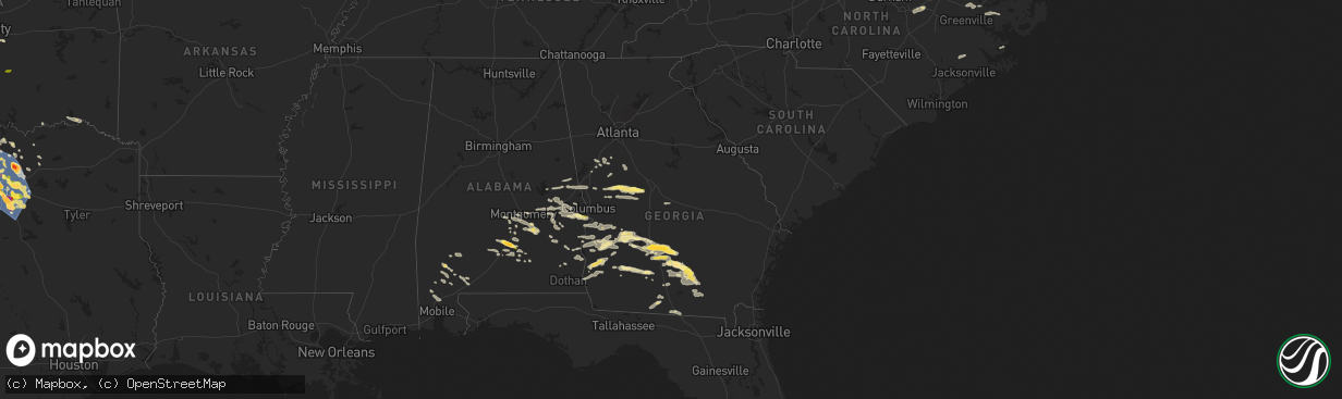
Hail Map in Georgia on May 27, 2024
The weather event in Georgia on May 27, 2024 includes Hail, Wind, and Tornado maps. 21 states and 946 cities were impacted and suffered possible damage. The total estimated number of properties impacted is 8,671.
Want more than just the map?
Turn this storm into a full workflow.
- Owner + property data so you know who to knock
- OnDemand branded weather history reports to win the "did we even have hail?" argument
- RoofTrace estimate so reps stop guessing numbers at the door
Bought this map? Upgrade within 7 days and we'll credit the $230. (10-15 min setup call)
Hail
Wind
Tornado
8,671
Estimated number of impacted properties by a 1.00" hail or larger135
Estimated number of impacted properties by a 1.75" hail or larger0
Estimated number of impacted properties by a 2.50" hail or largerStorm reports in Georgia
Georgia
| Date | Description |
|---|---|
| 05/27/20246:38 PM CDT | Trees down and powerlines down by bridgetown rd and old columbus rd. Time estimated by radar. |
| 05/27/20246:38 PM CDT | Trees down and powerlines down by mora rd. And bridgetown rd. Time estimated by radar. |
| 05/27/20246:35 PM CDT | Tree down on home off of bostwick st. Time estimated by radar. |
| 05/27/20246:20 PM CDT | The berrien county 911 dispatch reported a tree down on a home along wycliff roberts road. |
| 05/27/20245:55 PM CDT | The irwin county 911 dispatch reported several trees and powerlines down across the county. |
| 05/27/20245:45 PM CDT | A lot of trees and power lines down across the north end of berrien county... Especially from the irwin county line to alapaha. |
| 05/27/20245:39 PM CDT | Trees down near intersection of ferry lake rd and club house rd. |
| 05/27/20245:30 PM CDT | Trees down near ferry lake road and us hwy 319. |
| 05/27/20245:30 PM CDT | Member of the public reported lots of hail the size of at least quarters near w roanoke dr and jeff david hwy on the southwest side of fitzgerald. |
| 05/27/20245:30 PM CDT | The ben hill 911 dispatch reported several trees and powerlines down across the county. |
| 05/27/20245:25 PM CDT | Utility lines were reported down in the 900 block of the hwy 85 connector. |
| 05/27/20245:22 PM CDT | Trees down on a power line on nb side of i-75 at mm 71... Causing power lines to catch on fire. |
| 05/27/20245:20 PM CDT | Numerous trees and power lines down throughout ben hill county... West of town... In town... East of town. |
| 05/27/20245:18 PM CDT | Numerous downed trees and power lines throughout irwin county... With greatest concentration in western county. Power crews working to restore power. |
| 05/27/20245:05 PM CDT | Trees down along state hwy 107... Just west of the irwin county line. |
| 05/27/20245:02 PM CDT | Pictures of hail from the rebecca area. |
| 05/27/20245:01 PM CDT | A local report indicates 1.50 inch wind near Rebecca |
| 05/27/20244:59 PM CDT | Tree limb down in dawson. Also a power outage in the dawson area via ga power outage map. |
| 05/27/20244:45 PM CDT | A local report indicates 1.75 inch wind near Dakota |
| 05/27/20244:41 PM CDT | Quarter hail reported via ham radio in north turner county. |
| 05/27/20244:40 PM CDT | Hail estimated around quarter size. |
| 05/27/20244:35 PM CDT | Multiple trees and power lines down across the west side of turner county. |
| 05/27/20244:11 PM CDT | Trees down on scenic route south of georgia veterans state park. |
| 05/27/20244:00 PM CDT | Trees down at intersection of us-280 and bishop johnson circle road. |
| 05/27/20243:13 PM CDT | Trees down at intersection of us-280 and ga-49. |
| 05/27/202412:47 PM CDT | Trees down on oak grove church road roughly 3 miles south of musella. |
| 05/27/202412:45 PM CDT | Large tree limbs and branches greater than 2 inches in diameter down along carl sutton road. |
| 05/27/202412:40 PM CDT | Trees down at the intersection of hwy 80 and sandy point road. |
| 05/27/202412:33 PM CDT | Trees down at the intersection of hwy 80 and hopewell road. |
| 05/27/202412:33 PM CDT | Trees and powerlines down at montfort road and jeff young road. |
| 05/27/202412:30 PM CDT | Trees snapped and uprooted on oak grove church road a mile west of hwy 341. |
| 05/27/202412:16 PM CDT | Several trees down on powerlines near john b. Gordon rd and john gordon spur. |
| 05/27/202411:58 AM CDT | Several trees and powerlines reported down in the pleasant valley rd / manchester hwy area in woodland. |
| 05/27/202411:39 AM CDT | Trees down at intersection of manchester highway and pleasant valley road. |
| 05/27/202411:39 AM CDT | Trees down at intersection of manchester highway and pleasant valley road. |
| 05/27/202411:36 AM CDT | Two trees reported down near the intersection of judson bulloch rd and margaret ln. |
| 05/27/202411:15 AM CDT | Trees down along hwy 18 near nelson road. |
| 05/27/202411:06 AM CDT | Trees down along hwy 219 near mm14. Possible tornado. |
| 05/27/202410:48 AM CDT | Tree reported down at the intersection of smokey rd and briley rd. |
| 05/27/20247:53 AM CDT | Tree on house on james street. |
| 05/27/20247:50 AM CDT | Wires were reported down in the 1400 block of redwine rd. |
| 05/27/20247:50 AM CDT | Wires were downed on hwy 92 at peeples rd. |
| 05/27/20247:45 AM CDT | Wires were reported down in the 200 block of lee street. |
| 05/27/20247:45 AM CDT | Utility wires were reported down on ebenezer church rd at bridger point rd. |
| 05/27/20247:40 AM CDT | Tree reported down near the 500 block of maxham rd. |
| 05/27/20247:40 AM CDT | Wires were reported down on tyrone rd at ellison rd. |
| 05/27/20247:35 AM CDT | Public reports multiple trees down |
| 05/27/20247:35 AM CDT | Corrects previous tstm wnd dmg report from 3 ene thomas crossroads to include neighborhood name: highland park estates. Public reports multiple trees down |
| 05/27/20247:23 AM CDT | A brief tornado began near payton rd and boone rd in northwest coweta county just east of chattahoochee bend state park... Downing trees... Several falling on homes. Th |
| 05/27/20247:00 AM CDT | Tree reported down at the intersection of cole rd and liberty rd. |
| 05/26/202411:35 PM CDT | Tree down near 5335 second drive. |
| 05/26/202411:25 PM CDT | Tree down near the intersection of orr road and skipper bridge road. |
| 05/26/202411:21 PM CDT | Lanier county 911 reports power lines down on hwy 221. |
| 05/26/202411:20 PM CDT | Lanier county 911 reports a tree down on e burnt church rd. |
| 05/26/202411:10 PM CDT | The berrien county 911 dispatch reported a tree down on powerlines along ga hwy 168 between seaborn boyd rd and ba warren rd. |
| 05/26/20247:30 PM CDT | Tree down near the intersection of roberts road and wilbanks ave. |
All States Impacted by Hail Map on May 27, 2024
Cities Impacted by Hail Map on May 27, 2024
- Paducah, KY
- Ledbetter, KY
- Calvert City, KY
- Benton, KY
- Smithland, KY
- Grand Rivers, KY
- Paragould, AR
- Marmaduke, AR
- Success, AR
- Corning, AR
- Maynard, AR
- Yellville, AR
- Green Forest, AR
- Berryville, AR
- Alpena, AR
- Fairmount, GA
- Ranger, GA
- Talking Rock, GA
- Jasper, GA
- Chatsworth, GA
- Ellijay, GA
- Waleska, GA
- Canton, GA
- Rydal, GA
- White, GA
- Marble Hill, GA
- Tate, GA
- Ball Ground, GA
- Peachtree Corners, GA
- Duluth, GA
- Alpharetta, GA
- Norcross, GA
- Roswell, GA
- Dawsonville, GA
- Cumming, GA
- Woodstock, GA
- Marietta, GA
- Atlanta, GA
- Lawrenceville, GA
- Buford, GA
- Suwanee, GA
- Snellville, GA
- Lilburn, GA
- Grayson, GA
- Dacula, GA
- Loganville, GA
- Sanford, NC
- Moncure, NC
- Camp Hill, AL
- Waverly, AL
- Dadeville, AL
- Lafayette, AL
- Cusseta, AL
- Lanett, AL
- West Point, GA
- Valley, AL
- Pine Mountain, GA
- Hamilton, GA
- Trenton, NC
- Pine Mountain Valley, GA
- Shiloh, GA
- Woodland, GA
- Talbotton, GA
- Thomaston, GA
- Harrellsville, NC
- Cofield, NC
- Hobbsville, NC
- Gatesville, NC
- Sunbury, NC
- Culloden, GA
- Musella, GA
- Roberta, GA
- Shorter, AL
- Tallassee, AL
- Butler, GA
- Knoxville, GA
- Merritt, NC
- Lizella, GA
- Tuskegee, AL
- Auburn, AL
- Box Springs, GA
- New Ulm, MN
- Fairmont, MN
- Granada, MN
- Chillicothe, MO
- Hale, MO
- Nicollet, MN
- Junction City, GA
- Byron, GA
- Mapleton, MN
- Good Thunder, MN
- Amboy, MN
- Hamburg, MN
- Reynolds, GA
- Eufaula, AL
- Hatchechubbee, AL
- Union Springs, AL
- Seale, AL
- Waldorf, MN
- Abbeville, AL
- Fort Valley, GA
- Silver Lake, MN
- Pemberton, MN
- Morris, GA
- Easton, MN
- Minnesota Lake, MN
- Winsted, MN
- Lumpkin, GA
- Georgetown, GA
- Whitakers, NC
- Cuthbert, GA
- New Richland, MN
- Preston, GA
- Richland, GA
- Enfield, NC
- Cochran, GA
- Hurtsboro, AL
- Wendell, NC
- Clayton, NC
- Zebulon, NC
- Pittsview, AL
- Middlesex, NC
- Danville, GA
- Omaha, GA
- Laurel, IA
- Melbourne, IA
- Haverhill, IA
- Buena Vista, GA
- Parrott, GA
- Weston, GA
- Fort Mitchell, AL
- Plains, GA
- Dawson, GA
- Americus, GA
- Pleasant Hill, NC
- Garysburg, NC
- Walker, IA
- Brandon, IA
- Rowley, IA
- Gilman, IA
- Grinnell, IA
- Marshalltown, IA
- Battleboro, NC
- Kellogg, IA
- Pleasantville, IA
- Knoxville, IA
- Smithville, GA
- Emporia, VA
- Seaboard, NC
- Hope Hull, AL
- Montgomery, AL
- Cusseta, GA
- Central City, IA
- Center Point, IA
- Waverly, IA
- Leslie, GA
- De Soto, GA
- Alburnett, IA
- Excelsior, MN
- Minnetonka, MN
- Brooklyn, IA
- Deep River, IA
- Minneapolis, MN
- Madison Lake, MN
- Mankato, MN
- Waterloo, IA
- Chanhassen, MN
- Wayzata, MN
- Scotland Neck, NC
- Bussey, IA
- Tracy, IA
- Cobb, GA
- Hudson, IA
- Guernsey, IA
- Springville, IA
- Hamilton, IA
- Green Isle, MN
- Long Lake, MN
- Leakey, TX
- Robersonville, NC
- Bethel, NC
- Anamosa, IA
- Cordele, GA
- Shorterville, AL
- Fort Gaines, GA
- Martelle, IA
- Maple Grove, MN
- Dallas, TX
- Dunkerton, IA
- Dewar, IA
- Ramer, AL
- Pike Road, AL
- Mathews, AL
- Forest Home, AL
- Eagle Lake, MN
- Jesup, IA
- Kasota, MN
- Olin, IA
- La Porte City, IA
- Independence, IA
- Greenville, AL
- Warwick, GA
- Arabi, GA
- Ashburn, GA
- Shellman, GA
- Castell, TX
- Llano, TX
- Williamsburg, VA
- Hunt, TX
- Richardson, TX
- Garland, TX
- Caney, KS
- Atchison, KS
- Oskaloosa, KS
- Calera, OK
- Copan, OK
- Coleman, OK
- Le Roy, KS
- Wapanucka, OK
- Pomona, KS
- Holdenville, OK
- Valley Falls, KS
- Buffalo, KS
- Weleetka, OK
- Independence, KS
- Kenefic, OK
- Sperry, OK
- Okemah, OK
- Okmulgee, OK
- Bartlesville, OK
- Mckinney, TX
- Van Alstyne, TX
- Westphalia, KS
- Tupelo, OK
- Allen, OK
- Plano, TX
- Yates Center, KS
- Williamsburg, KS
- Milburn, OK
- Dewey, OK
- Sapulpa, OK
- Celina, TX
- Mead, OK
- Durant, OK
- Anna, TX
- Beggs, OK
- Wann, OK
- Melvern, KS
- Calvin, OK
- Overbrook, KS
- Winchester, KS
- Neosho Falls, KS
- Wetumka, OK
- Colbert, OK
- Waverly, KS
- Fredonia, KS
- Sherman, TX
- Centrahoma, OK
- Skiatook, OK
- Cummings, KS
- Mounds, OK
- Perry, KS
- Tulsa, OK
- Allen, TX
- Altoona, KS
- Atwood, OK
- Tyro, KS
- Nortonville, KS
- Lecompton, KS
- Lancaster, KS
- Neodesha, KS
- Ochelata, OK
- Benedict, KS
- Howe, TX
- Lawrence, KS
- Denison, TX
- Kiefer, OK
- Quenemo, KS
- Ramona, OK
- Vanderpool, TX
- Winthrop, IA
- Oxford Junction, IA
- Clarence, IA
- Irving, TX
- Halifax, NC
- Williamston, NC
- Fitzpatrick, AL
- Littleton, NC
- Wyoming, IA
- Lost Nation, IA
- Wheatland, IA
- Lowden, IA
- Barksdale, TX
- Whatley, AL
- Gloucester, VA
- North, VA
- Notasulga, AL
- Rebecca, GA
- Medina, TX
- Pontotoc, TX
- Sumner, GA
- Honoraville, AL
- Troy, AL
- Grady, AL
- Bloomfield, IA
- Ottumwa, IA
- Drakesville, IA
- Leroy, AL
- Saint Stephens, AL
- Grove Hill, AL
- Albertville, MN
- Elk River, MN
- Janesville, IA
- New Hartford, IA
- Cedar Falls, IA
- Valley Spring, TX
- Franklin, AL
- Chula, GA
- Tifton, GA
- Sycamore, GA
- Jackson, AL
- Jamesville, NC
- Floris, IA
- Evansdale, IA
- Raymond, IA
- Lowndesboro, AL
- Senoia, GA
- Frederick, MD
- Ijamsville, MD
- Rochelle, GA
- Fitzgerald, GA
- Sylvester, GA
- Poulan, GA
- Camp Wood, TX
- Shell Rock, IA
- Fairbank, IA
- Gilbertville, IA
- Quasqueton, IA
- Ryan, IA
- Manchester, IA
- Masonville, IA
- Coggon, IA
- Vinton, IA
- Urbana, IA
- Monticello, IA
- Hopkinton, IA
- Prairieburg, IA
- Marion, IA
- Monmouth, IA
- Onslow, IA
- Cascade, IA
- Langworthy, IA
- Center Junction, IA
- Fredericksburg, TX
- Monrovia, MD
- Damascus, MD
- Hutchins, TX
- Mount Airy, MD
- Pine Apple, AL
- Georgiana, AL
- Bluffton, GA
- Coleman, GA
- Blakely, GA
- Luverne, AL
- Windsor, NC
- Ocilla, GA
- Willow City, TX
- Lancaster, TX
- Wilmer, TX
- Seagoville, TX
- Sharpsburg, GA
- Salem, AL
- Opelika, AL
- Hertford, NC
- Elizabeth City, NC
- Banks, AL
- Milton, IA
- Douds, IA
- Cantril, IA
- Arlington, GA
- Pinetown, NC
- Plymouth, NC
- Edison, GA
- Uriah, AL
- Princeton, IA
- Long Grove, IA
- Ferris, TX
- Crandall, TX
- Forney, TX
- Hayneville, AL
- Ashburn, VA
- Pantego, NC
- Enigma, GA
- Louisville, AL
- Clayton, AL
- Tuskegee Institute, AL
- Kerrville, TX
- Arbela, MO
- Luray, MO
- Rutledge, AL
- Wagarville, AL
- Ingram, TX
- Mount Sterling, IA
- Port Byron, IL
- Morgan, GA
- Marriottsville, MD
- Randallstown, MD
- Woodstock, MD
- Owings Mills, MD
- Comfort, TX
- Blakesburg, IA
- Kahoka, MO
- Pulaski, IA
- Portsmouth, VA
- Norfolk, VA
- Virginia Beach, VA
- Alapaha, GA
- Round Mountain, TX
- San Saba, TX
- Richland Springs, TX
- Winston Salem, NC
- Cedar Park, TX
- Carrollton, VA
- Bryson City, NC
- Chickamauga, GA
- Sylva, NC
- Winona, MS
- Oak Grove, LA
- Collinston, LA
- Cohutta, GA
- Haleyville, AL
- Hiddenite, NC
- Elon, NC
- Nebo, NC
- Eupora, MS
- Choudrant, LA
- Clemmons, NC
- Hutto, TX
- Ivor, VA
- Canton, NC
- Lenoir, NC
- Tunnel Hill, GA
- La Crosse, VA
- Copperhill, TN
- Crockett, TX
- Sidon, MS
- Crandall, GA
- Lewisville, NC
- Ider, AL
- Murphy, NC
- Tenaha, TX
- Nacogdoches, TX
- Old Fort, NC
- Capron, VA
- Amory, MS
- Rising Fawn, GA
- Woodville, AL
- Normangee, TX
- Reidsville, NC
- Cruger, MS
- Cedarbluff, MS
- Hollandale, MS
- Union Grove, AL
- Prairie, MS
- Morganton, NC
- Roxboro, NC
- Oxford, NC
- Bullock, NC
- Centerville, TX
- Guin, AL
- Rock Spring, GA
- Turtletown, TN
- Taylorsville, NC
- Round Rock, TX
- Gibsonville, NC
- Oak Ridge, NC
- Gasburg, VA
- Ebony, VA
- West Point, MS
- Douglass, TX
- Topton, NC
- Sedley, VA
- Cameron, TX
- Greensboro, NC
- Brilliant, AL
- Smithfield, VA
- Vinemont, AL
- Candler, NC
- Andrews, NC
- Sterlington, LA
- Downsville, LA
- Boydton, VA
- Yanceyville, NC
- Yadkinville, NC
- White Plains, VA
- Rockdale, TX
- Hudson, NC
- Walkertown, NC
- Addison, AL
- Waynesville, NC
- Kernersville, NC
- Garrison, TX
- Windsor, VA
- Marion, NC
- Austin, TX
- Falkville, AL
- Leasburg, NC
- Kilmichael, MS
- Black Mountain, NC
- Dalton, GA
- Swannanoa, NC
- Grand Cane, LA
- Scottsboro, AL
- Woodland, MS
- Mer Rouge, LA
- Somerville, AL
- Hamilton, AL
- Eva, AL
- Bastrop, LA
- Asheville, NC
- Double Springs, AL
- Lawrenceville, VA
- Greenwood Springs, MS
- Franklin, TX
- Harmony, NC
- Dutton, AL
- Joaquin, TX
- Summerfield, NC
- Pisgah, AL
- Sulligent, AL
- Granite Falls, NC
- Olin, NC
- Henderson, NC
- Leander, TX
- Grapeland, TX
- Brodnax, VA
- Logansport, LA
- Ruston, LA
- Courtland, VA
- Zuni, VA
- Ringgold, GA
- Balsam, NC
- Browns Summit, NC
- Alto, TX
- Mantee, MS
- Whittier, NC
- Spicewood, TX
- Statesville, NC
- Grant, AL
- Bracey, VA
- Mocksville, NC
- Aberdeen, MS
- Coila, MS
- Mansfield, LA
- Willacoochee, GA
- Justin, TX
- Southlake, TX
- Grapevine, TX
- Argyle, TX
- Flower Mound, TX
- Lewisville, TX
- Roanoke, TX
- Wray, GA
- Sterling, VA
- Hillsdale, IL
- Ennis, TX
- Mason, TX
- Windsor Mill, MD
- Pikesville, MD
- Fort Worth, TX
- Griffin, GA
- Milner, GA
- Ambrose, GA
- Great Falls, VA
- Potomac, MD
- Baltimore, MD
- Stevenson, MD
- Palmer, TX
- Geneseo, IL
- Erie, IL
- Prophetstown, IL
- Horseshoe Bay, TX
- Atmore, AL
- Woodbury, GA
- Brantley, AL
- Nashville, GA
- Lenox, GA
- Bronwood, GA
- Fort Deposit, AL
- Letohatchee, AL
- Saint Patrick, MO
- Tampico, IL
- Hooppole, IL
- Annawan, IL
- Mineral, IL
- Sheffield, IL
- Marble Falls, TX
- Goldthwaite, TX
- Keller, TX
- Molena, GA
- Kingsland, TX
- Stockton, AL
- Rocksprings, TX
- Little River, AL
- Red Oak, TX
- Johnson City, TX
- Harper, TX
- McIntosh, AL
- Dozier, AL
- Pearson, GA
- Chatham, LA
- Mendenhall, MS
- Bienville, LA
- Ringgold, LA
- Winnsboro, LA
- Elba, AL
- Sale City, GA
- Jamestown, LA
- Jonesboro, LA
- Ozark, AL
- Coffeeville, AL
- Heidelberg, MS
- Kaufman, TX
- Bay Springs, MS
- Gilbertown, AL
- Grayson, LA
- Shreveport, LA
- Tatum, TX
- Kemp, TX
- Newville, AL
- Magee, MS
- Lower Peach Tree, AL
- Utica, MS
- Scurry, TX
- Tyler, TX
- Elm Grove, LA
- Terry, MS
- Dickinson, AL
- Leary, GA
- Norman Park, GA
- Crystal Springs, MS
- Columbia, LA
- Newton, GA
- Keithville, LA
- Headland, AL
- Braxton, MS
- Taylorsville, MS
- Kilgore, TX
- Longview, TX
- Raleigh, MS
- Mize, MS
- Shubuta, MS
- Port Gibson, MS
- Mabank, TX
- Beatrice, AL
- Marshall, TX
- Vossburg, MS
- Florence, MS
- Ben Wheeler, TX
- De Berry, TX
- Moultrie, GA
- Canton, TX
- Stonewall, LA
- Jack, AL
- Peterman, AL
- Bethany, LA
- Hardaway, AL
- Colleyville, TX
- North Richland Hills, TX
- Herndon, VA
- Center Point, TX
- Mountain Home, TX
- Hurst, TX
- Lometa, TX
- Gwynn Oak, MD
- Glenwood, AL
- Burnet, TX
- Bedford, TX
- Euless, TX
- Lapine, AL
- Barnesville, GA
- Laredo, TX
- Adel, GA
- Lakeland, GA
- Vienna, VA
- Reston, VA
- Albany, GA
- Luthersville, GA
- Grand Prairie, TX
- Arlington, TX
- Grantville, GA
- Moreland, GA
- Yatesville, GA
- Homerville, GA
- Midway, AL
- Citronelle, AL
- Chunchula, AL
- Highland Home, AL
- Brooks, GA
- Baconton, GA
- McNabb, IL
- Lostant, IL
- Axis, AL
- Duncanville, TX
- Mansfield, TX
- Doerun, GA
- Saraland, AL
- Creola, AL
- Plainville, IL
- Hogansville, GA
- Greenville, GA
- Kinderhook, IL
- Barry, IL
- Cedar Hill, TX
- Leesburg, GA
- Du Pont, GA
- Quitman, GA
- Dixie, GA
- New Canton, IL
- Camilla, GA
- Omega, GA
- Haslet, TX
- Rhome, TX
- Roma, TX
- Sykesville, MD
- Boyds, MD
- Germantown, MD
- Oakfield, GA
- New Market, MD
- Sullivan City, TX
- Decatur, TX
- Ponder, TX
- Rio Grande City, TX
- Grulla, TX
- Springtown, TX
- Zapata, TX
- Krum, TX
- Mission, TX
- Edinburg, TX
- Damascus, GA
- Valdosta, GA
- Perrin, TX
- Whitt, TX
- Guerra, TX
- Denton, TX
- Sanger, TX
- Lake Park, GA
- Jacksboro, TX
- Graford, TX
- Jennings, FL
- Bryson, TX
- Morven, GA
- Barney, GA
- Bennington, OK
- Willow Spring, NC
- Nashville, NC
- Garner, NC
- Rocky Mount, NC
- Wagram, NC
- Laurel Hill, NC
- Wallace, SC
- Lillington, NC
- Spring Hope, NC
- Marston, NC
- Raeford, NC
- Spring Lake, NC
- Angier, NC
- Cheraw, SC
- Bennettsville, SC
- Bunnlevel, NC
- Fort Bragg, NC
- Woodbine, MD
- Seymour, TX
- Towson, MD
- Waurika, OK
- Ryan, OK
- Throckmorton, TX
- Electra, TX
- Temple, OK
- Walters, OK
- Comanche, OK
- Kulm, ND
- Harrold, TX
- Tallahassee, FL
- Havana, FL
- Ringling, OK
- Chillicothe, TX
- Edgeley, ND
- Grandfield, OK
- Faxon, OK
- Lawton, OK
- Loveland, OK
- Forbes, ND
- Loco, OK
- Duncan, OK
- Geronimo, OK
- Oklaunion, TX
- Frederick, OK
- Davidson, OK
- Healdton, OK
- Ratliff City, OK
- Graham, OK
- Chattanooga, OK
- Hastings, OK
- Marlow, OK
- Foster, OK
- Hennepin, OK
- Tussy, OK
- Springer, OK
- Elmore City, OK
- Elmer, OK
- Apache, OK
- Davis, OK
- Elgin, OK
- Iowa Park, TX
- Wichita Falls, TX
- Wynnewood, OK
- Lindsay, OK
- Vernon, TX
- Fletcher, OK
- Rush Springs, OK
- Mountain View, OK
- Henrietta, TX
- Roosevelt, OK
- Indiahoma, OK
- Snyder, OK
- Ringgold, TX
- Hollis, OK
- Carnegie, OK
- Wellington, TX
- Wilson, OK
- Gainesville, TX
- Sulphur, OK
- Carter, OK
- Rocky, OK
- Whitesboro, TX
- Thackerville, OK
- Marietta, OK
- Sentinel, OK
- Burneyville, OK
- Roff, OK
- Dill City, OK
- Hobart, OK
- Bellevue, TX
- Lone Wolf, OK
- Byers, TX
- Petrolia, TX
- Bowie, TX
- Nocona, TX
- Gotebo, OK
- Maud, OK
- Gould, OK
- Tecumseh, OK
- Collinsville, TX
- Earlsboro, OK
- Shawnee, OK
- Burkburnett, TX
- Devol, OK
- Randlett, OK
- Sunset, TX
- Chico, TX
- Seminole, OK
- Tioga, TX
- Valley View, TX
- Alvord, TX
- Forestburg, TX
- Hugo, OK
- Saint Jo, TX
- Duke, OK
- Aubrey, TX
- Pilot Point, TX
- Gunter, TX
- Grant, OK
- Fort Towson, OK
- Bridgeport, TX
- Olustee, OK
- Paradise, TX
- Rosston, TX
- Sawyer, OK
- Detroit, TX
- Prosper, TX
- Frisco, TX
- Mountain Park, OK
- Little Elm, TX
- Princeton, TX
- Altus, OK
- Headrick, OK
- Cache, OK
- Boyd, TX
- Lake Dallas, TX
- The Colony, TX
- Bonham, TX
- Newark, TX
- Carrollton, TX
- St John, KS
- Tipton, OK
- Blue Ridge, TX
- Hollister, OK
- Addison, TX
- Coppell, TX
- Azle, TX
- Pawnee Rock, KS
- Greenville, TX
- Melissa, TX
- Farmersville, TX
- Caddo Mills, TX
- Sachse, TX
- Royse City, TX
- Lavon, TX
- Naval Air Station Jrb, TX
- Nevada, TX
- Wylie, TX
- Haltom City, TX
- Rockwall, TX
- Rowlett, TX
- Alexander, KS
- Wolfe City, TX
- Mesquite, TX
- Sunnyvale, TX
- Midlothian, TX
- Desoto, TX
- Balch Springs, TX
- Montague, TX
- Era, TX
- Muenster, TX
- Whitewright, TX
- Rush Center, KS
- Terrell, TX
- Waxahachie, TX
- Larned, KS
- Leonard, TX
- Celeste, TX
- Rosser, TX
- Rice, TX
- Holliday, TX
- Olney, TX
- Windthorst, TX
- Chatfield, TX
- Trinidad, TX
- Powell, TX
- Kerens, TX
- Eustace, TX
- Malakoff, TX
- Ada, OK
- Barnesville, PA
- Anadarko, OK


