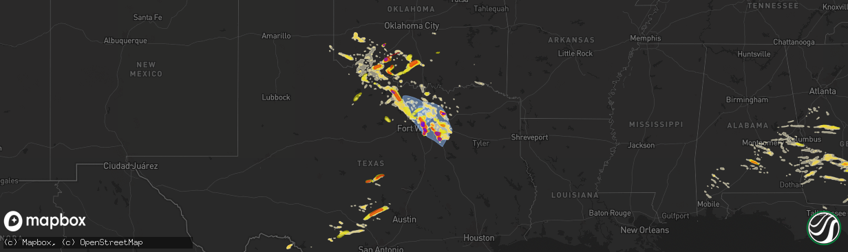
Hail Map on May 27, 2024
The weather event on May 27, 2024 includes Hail, Wind, and Tornado maps. 21 states and 946 cities were impacted and suffered possible damage. The total estimated number of properties impacted is 424,554.
Want more than just the map?
Turn this storm into a full workflow.
- Owner + property data so you know who to knock
- OnDemand branded weather history reports to win the "did we even have hail?" argument
- RoofTrace estimate so reps stop guessing numbers at the door
Bought this map? Upgrade within 7 days and we'll credit the $230. (10-15 min setup call)
Hail
Wind
Tornado
424,554
Estimated number of impacted properties by a 1.00" hail or larger189,832
Estimated number of impacted properties by a 1.75" hail or larger114,483
Estimated number of impacted properties by a 2.50" hail or largerStates Impacted by Hail Map on May 27, 2024
Storm reports
Georgia
| Date | Description |
|---|---|
| 05/27/20246:38 PM CDT | Trees down and powerlines down by mora rd. And bridgetown rd. Time estimated by radar. |
| 05/27/20246:38 PM CDT | Trees down and powerlines down by bridgetown rd and old columbus rd. Time estimated by radar. |
| 05/27/20246:35 PM CDT | Tree down on home off of bostwick st. Time estimated by radar. |
| 05/27/20246:20 PM CDT | The berrien county 911 dispatch reported a tree down on a home along wycliff roberts road. |
| 05/27/20245:55 PM CDT | The irwin county 911 dispatch reported several trees and powerlines down across the county. |
| 05/27/20245:45 PM CDT | A lot of trees and power lines down across the north end of berrien county... Especially from the irwin county line to alapaha. |
| 05/27/20245:39 PM CDT | Trees down near intersection of ferry lake rd and club house rd. |
| 05/27/20245:30 PM CDT | Member of the public reported lots of hail the size of at least quarters near w roanoke dr and jeff david hwy on the southwest side of fitzgerald. |
| 05/27/20245:30 PM CDT | The ben hill 911 dispatch reported several trees and powerlines down across the county. |
| 05/27/20245:30 PM CDT | Trees down near ferry lake road and us hwy 319. |
| 05/27/20245:25 PM CDT | Utility lines were reported down in the 900 block of the hwy 85 connector. |
| 05/27/20245:22 PM CDT | Trees down on a power line on nb side of i-75 at mm 71... Causing power lines to catch on fire. |
| 05/27/20245:20 PM CDT | Numerous trees and power lines down throughout ben hill county... West of town... In town... East of town. |
| 05/27/20245:18 PM CDT | Numerous downed trees and power lines throughout irwin county... With greatest concentration in western county. Power crews working to restore power. |
| 05/27/20245:05 PM CDT | Trees down along state hwy 107... Just west of the irwin county line. |
| 05/27/20245:02 PM CDT | Pictures of hail from the rebecca area. |
| 05/27/20245:01 PM CDT | A local report indicates 1.50 inch wind near Rebecca |
| 05/27/20244:59 PM CDT | Tree limb down in dawson. Also a power outage in the dawson area via ga power outage map. |
| 05/27/20244:45 PM CDT | A local report indicates 1.75 inch wind near Dakota |
| 05/27/20244:41 PM CDT | Quarter hail reported via ham radio in north turner county. |
| 05/27/20244:40 PM CDT | Hail estimated around quarter size. |
| 05/27/20244:35 PM CDT | Multiple trees and power lines down across the west side of turner county. |
| 05/27/20244:11 PM CDT | Trees down on scenic route south of georgia veterans state park. |
| 05/27/20244:00 PM CDT | Trees down at intersection of us-280 and bishop johnson circle road. |
| 05/27/20243:13 PM CDT | Trees down at intersection of us-280 and ga-49. |
| 05/27/202412:47 PM CDT | Trees down on oak grove church road roughly 3 miles south of musella. |
| 05/27/202412:45 PM CDT | Large tree limbs and branches greater than 2 inches in diameter down along carl sutton road. |
| 05/27/202412:40 PM CDT | Trees down at the intersection of hwy 80 and sandy point road. |
| 05/27/202412:33 PM CDT | Trees down at the intersection of hwy 80 and hopewell road. |
| 05/27/202412:33 PM CDT | Trees and powerlines down at montfort road and jeff young road. |
| 05/27/202412:30 PM CDT | Trees snapped and uprooted on oak grove church road a mile west of hwy 341. |
| 05/27/202412:16 PM CDT | Several trees down on powerlines near john b. Gordon rd and john gordon spur. |
| 05/27/202411:58 AM CDT | Several trees and powerlines reported down in the pleasant valley rd / manchester hwy area in woodland. |
| 05/27/202411:39 AM CDT | Trees down at intersection of manchester highway and pleasant valley road. |
| 05/27/202411:39 AM CDT | Trees down at intersection of manchester highway and pleasant valley road. |
| 05/27/202411:36 AM CDT | Two trees reported down near the intersection of judson bulloch rd and margaret ln. |
| 05/27/202411:15 AM CDT | Trees down along hwy 18 near nelson road. |
| 05/27/202411:06 AM CDT | Trees down along hwy 219 near mm14. Possible tornado. |
| 05/27/202410:48 AM CDT | Tree reported down at the intersection of smokey rd and briley rd. |
| 05/27/20247:53 AM CDT | Tree on house on james street. |
| 05/27/20247:50 AM CDT | Wires were reported down in the 1400 block of redwine rd. |
| 05/27/20247:50 AM CDT | Wires were downed on hwy 92 at peeples rd. |
| 05/27/20247:45 AM CDT | Utility wires were reported down on ebenezer church rd at bridger point rd. |
| 05/27/20247:45 AM CDT | Wires were reported down in the 200 block of lee street. |
| 05/27/20247:40 AM CDT | Wires were reported down on tyrone rd at ellison rd. |
| 05/27/20247:40 AM CDT | Tree reported down near the 500 block of maxham rd. |
| 05/27/20247:35 AM CDT | Public reports multiple trees down |
| 05/27/20247:35 AM CDT | Corrects previous tstm wnd dmg report from 3 ene thomas crossroads to include neighborhood name: highland park estates. Public reports multiple trees down |
| 05/27/20247:23 AM CDT | A brief tornado began near payton rd and boone rd in northwest coweta county just east of chattahoochee bend state park... Downing trees... Several falling on homes. Th |
| 05/27/20247:00 AM CDT | Tree reported down at the intersection of cole rd and liberty rd. |
| 05/26/202411:35 PM CDT | Tree down near 5335 second drive. |
| 05/26/202411:25 PM CDT | Tree down near the intersection of orr road and skipper bridge road. |
| 05/26/202411:21 PM CDT | Lanier county 911 reports power lines down on hwy 221. |
| 05/26/202411:20 PM CDT | Lanier county 911 reports a tree down on e burnt church rd. |
| 05/26/202411:10 PM CDT | The berrien county 911 dispatch reported a tree down on powerlines along ga hwy 168 between seaborn boyd rd and ba warren rd. |
| 05/26/20247:30 PM CDT | Tree down near the intersection of roberts road and wilbanks ave. |
Mississippi
| Date | Description |
|---|---|
| 05/27/202412:18 AM CDT | Mesonet station ptbm6 petit bois is |
Missouri
| Date | Description |
|---|---|
| 05/27/20246:20 PM CDT | Corrects previous tstm wnd dmg report from kahoka. 911 dispatch center reported one large tree down in the town of kahoka. Time estimated by radar. There was also lots |
| 05/27/20246:20 PM CDT | 911 dispatch center reported one large tree down in the town of kahoka. Time estimated by radar. There was also lots of small hail with the largest size being the size |
| 05/27/20246:00 PM CDT | Time estimated by radar. |
| 05/27/20245:45 PM CDT | Damage to cars... Outbuildings and trees... And debris driven into siding of house. Swirl marks noted in grass. Possible brief tornado. |
| 05/27/20245:45 PM CDT | Wind damage was also noted from this storm to sheds... Houses... And trees. |
| 05/27/20245:45 PM CDT | Time estimated from radar. |
| 05/27/20245:45 PM CDT | Wind damage was also noted from this storm to sheds... Houses... And trees. |
| 05/27/20244:28 PM CDT | Tree down that took power lines down... Time estimated by radar. |
| 05/27/20244:28 PM CDT | Tree down that took power lines down... Time estimated by radar. D one large tree down in the town of kahoka. Time estimated by r |
| 05/27/20244:20 PM CDT | Tree down over a roadway... Time estimated by radar. |
| 05/27/20244:15 PM CDT | Tree fell on power lines... Time estimated by radar. |
| 05/27/20243:17 PM CDT | Large tree fell across electric lines... Time estimated from radar. |
| 05/27/20243:17 PM CDT | Large tree down pulled live power lines on to home... Time estimated by radar. |
Oklahoma
| Date | Description |
|---|---|
| 05/27/20245:10 AM CDT | A local report indicates 1.00 inch wind near Duke |
| 05/27/20244:00 AM CDT | A local report indicates 1.00 inch wind near 1 SW Ada |
| 05/27/20243:17 AM CDT | A local report indicates 2.50 inch wind near Retrop |
| 05/27/20242:20 AM CDT | Time estimated from radar. |
| 05/27/20242:15 AM CDT | Delayed report. Social media image. Caliper measurement of melted hailstone with 2.4 inch diameter. Radar estimated time. |
| 05/27/20242:10 AM CDT | Power poles snapped... Tree limbs broken. Time estimated from radar. |
| 05/27/20242:05 AM CDT | Time estimated from radar. |
| 05/27/20241:46 AM CDT | Report from mping: quarter |
| 05/27/20241:46 AM CDT | A local report indicates 1.50 inch wind near Ratliff City |
| 05/27/20241:45 AM CDT | Delayed report. Relayed image. |
| 05/27/20241:40 AM CDT | Also reported a cracked window and dents in vehicle. |
| 05/27/20241:20 AM CDT | Report from mping: golf ball |
Maryland
| Date | Description |
|---|---|
| 05/27/20246:49 PM CDT | Several trees and wires blew down around four corners. |
| 05/27/20246:47 PM CDT | Several trees and wires blew down around kensington. |
| 05/27/20246:44 PM CDT | Several trees and wires down near i-270 near rockville. |
| 05/27/20246:40 PM CDT | Trees blew down along us-40 baltimore national pike between pebble beach drive and frederick road. |
| 05/27/20246:35 PM CDT | Large tree limbs blew down in the 400 block of old home road. |
| 05/27/20246:28 PM CDT | Several trees and wires blew down near potomac. |
| 05/27/20246:24 PM CDT | A couple of trees and wires blew down and a house was struck by lightning on malvern court. |
| 05/27/20246:10 PM CDT | Trees blew down along northbound i-83 prior to i-695 baltimore beltway. |
| 05/27/20246:07 PM CDT | Several trees and large tree limbs blew down along md-144 frederick road near woodbine. |
| 05/27/20244:54 PM CDT | Quarter size hail was observed near mount airy. |
| 05/26/20248:55 PM CDT | Report of a tree down on powerlines. Time estimated from radar. Looks to have occurred with outflow boundary. |
| 05/26/20248:34 PM CDT | Report of trees down on powerlines in ridgely. Time estimated from radar. |
| 05/26/20247:34 PM CDT | Trees blew down along md-564 lanham severn road near santa cruz street. |
Virginia
| Date | Description |
|---|---|
| 05/27/20245:18 PM CDT | Reports of power lines down near bookers lane and route 14. Relayed via social media. |
| 05/27/20245:11 PM CDT | Awos station kngu norfolk nas cham. |
| 05/27/20245:09 PM CDT | Large tree was knocked down on commodore drive in the commodore park neighborhood of norfolk. Pictures relayed via social media and time is estimated from radar. |
| 05/27/20245:06 PM CDT | Relayed via social media. |
| 05/27/20245:05 PM CDT | Wires down on florence and milton drive in hampton. Time estimated. |
| 05/27/20244:58 PM CDT | Corrects previous tstm wnd dmg report from northampton. Wires down on florence and milton drive in hampton. Time estimated. |
| 05/27/20244:45 PM CDT | Tree down on mill creek rd in zuni. |
| 05/26/20247:03 PM CDT | Several trees blew down in clifton... Including near the intersection of va-612 old yates ford road and va-643 henderson road. |
Pennsylvania
| Date | Description |
|---|---|
| 05/27/20246:42 PM CDT | Multiple trees down. Possible tornado damage. |
| 05/27/20246:42 PM CDT | Roof damage to high school. |
| 05/27/20246:38 PM CDT | Ef1 tornado confirmed in mahanoy city. Estimated max wind 90mph. Width estimated at 75 yds. Length of 1.5 mi. |
| 05/26/20248:33 PM CDT | Report of a trees down in smithfield twp. |
| 05/26/20248:21 PM CDT | Report of a few trees down in stroud twp. |
| 05/26/20248:18 PM CDT | A few trees down spread throughout hamilton twp. |
| 05/26/20248:11 PM CDT | Report of a tree down in jackson twp. |
| 05/26/20247:35 PM CDT | Tree down. |
Illinois
| Date | Description |
|---|---|
| 05/27/20246:30 PM CDT | Atleast 60 mph winds. |
| 05/27/20246:22 PM CDT | Report gathered from social media of a few three inch diameter tree branches downed by the thunderstorm winds. Time estimated by radar. |
| 05/26/20247:40 PM CDT | A large tree was blown onto a car and power lines. |
| 05/26/20247:20 PM CDT | 8 inch diameter tree limb broke off of a tree and took down a powerline. Reported from a trained spotter on social media... With time estimated by radar. |
| 05/26/20247:20 PM CDT | Report on social media from a trained spotter of a large tree limb down across the road. At least 8 to 10 inches in diameter. Time estimated by radar. |
| 05/26/20247:20 PM CDT | 12 inch diameter tree down across illinois highway 26. Time estimated by radar. |
North Carolina
| Date | Description |
|---|---|
| 05/27/20246:30 PM CDT | Delayed report. Large tree limbs blown down. A funnel cloud was noted at this location as well. |
| 05/27/20246:15 PM CDT | Weather station at first flight park reported a 53 knot wind gusts. |
| 05/27/20246:15 PM CDT | Weather station at first flight park reported a 53 knot wind gusts. |
| 05/27/20246:15 PM CDT | Dominion power reported outages near manteo due to thunderstorm winds. Time estimated by radar. |
| 05/27/20246:14 PM CDT | Trees down in manteo. Time estimated by radar. |
| 05/27/20246:13 PM CDT | Dominion power reported outages near nags head due to thunderstorm winds. Time estimated by radar. |
| 05/27/20246:11 PM CDT | Trees down in nags head. |
| 05/27/20246:01 PM CDT | Cluster of 50 power outages just nw of harbinger... Nc. Time estimated. |
| 05/27/20245:23 PM CDT | Dominion power reported outages near pea ridge due to thunderstorm winds. |
| 05/27/20245:23 PM CDT | Corrects previous tstm wnd dmg report from 4 nw scuppernong. Dominion power reported outages near pea ridge due to thunderstorm winds. Time estimated by radar. |
| 05/27/20245:22 PM CDT | Tree down. |
| 05/27/20245:15 PM CDT | Multiple power outages just southwest of hertford due to storm. Time estimated. |
| 05/27/20244:40 PM CDT | Large tree down in williamston. Time estimated by radar. |
| 05/27/20244:30 PM CDT | Power outages reported in and around powellsville. Roughly 500 dominion customers without power. |
| 05/27/20244:25 PM CDT | Multiple clusters of power outages between ahoskie and cofield. Over 600 dominion customers without power. |
| 05/27/20244:10 PM CDT | Large tree down in hamilton. Time estimated by radar. |
| 05/27/20244:00 PM CDT | Multiple power outages due to storm in kelford. Time estimated. |
| 05/27/20243:52 PM CDT | Trees down along hwy 97. |
| 05/27/20243:47 PM CDT | Trees and powerlines down on downing dr. Radar estimated time. |
| 05/27/20243:25 PM CDT | Tree down on hwy 97 near tarboro rd. |
| 05/27/20243:08 PM CDT | Utility company reports several hundred outages due to fallen trees on lines. |
| 05/27/20242:40 PM CDT | Large tree limbs down at mattox st and old zebulon rd. |
| 05/27/20242:37 PM CDT | Tree down east of wendell along 3rd street. |
| 05/27/20242:33 PM CDT | A local report indicates 1.00 inch wind near 4 WNW Enfield |
| 05/27/20242:32 PM CDT | Utility company reports power outage for 1k people caused by fallen trees on lines. |
| 05/27/20247:45 AM CDT | A large tree was uprooted and fell across scott rd and onto adjacent power lines. Time estimated from radar. |
| 05/27/20247:42 AM CDT | Duke energy reported an outage caused by fallen trees or limbs damaging equipment. Time estimated from radar. |
Minnesota
| Date | Description |
|---|---|
| 05/27/20243:56 PM CDT | A local report indicates 1.00 inch wind near 3 W Madison Lake |
New York
| Date | Description |
|---|---|
| 05/27/20246:35 PM CDT | Trees and wires reported down on franklin street. |
| 05/27/20243:20 PM CDT | Downed powerlines |
| 05/27/20242:57 PM CDT | Downed tree into powerlines |
| 05/27/20242:40 PM CDT | Large maple do |
| 05/27/20242:40 PM CDT | Large maple down on powerline with broken pole... Rerouting traffic on route 10. Via county dispatch feed. Exact time and location estimated. |
| 05/27/20242:02 PM CDT | Tree down. |
| 05/26/20247:37 PM CDT | Report of a tree down on a house. Unknown if there are any injuries. Time is based on radar. |
Florida
| Date | Description |
|---|---|
| 05/27/20241:28 AM CDT | A tree resulted in a power outage via the talquin electric outage map. |
| 05/27/20241:26 AM CDT | Large tree down near meridian rd and bradford rd. Time estimated by radar. |
Texas
| Date | Description |
|---|---|
| 05/27/20246:59 PM CDT | Report from mping: quarter |
| 05/27/20246:58 PM CDT | Report from mping: quarter |
| 05/27/20246:56 PM CDT | Report from mping: quarter |
| 05/27/20246:53 PM CDT | Quarter size hail grapevine. |
| 05/27/20246:52 PM CDT | Report from mping: quarter |
| 05/27/20246:46 PM CDT | Report from mping: quarter |
| 05/27/20246:46 PM CDT | Golf ball size hail in mills. |
| 05/27/20246:46 PM CDT | Report from mping: quarter |
| 05/27/20246:39 PM CDT | Report from mping: quarter |
| 05/27/20246:37 PM CDT | Report from mping: quarter |
| 05/27/20246:34 PM CDT | Golf ball sized hail east of palmer 2 miles on rd 813. |
| 05/27/20246:32 PM CDT | Delayed report. Public reported ping pong to golf ball hail just west of double oak. Time estimated by radar. |
| 05/27/20246:31 PM CDT | Marble to ping pong ball hail seventeen lakes. |
| 05/27/20246:29 PM CDT | Ping pong ball sized hail in roanoke. |
| 05/27/20246:27 PM CDT | Delayed report. Public reported 2 inch hail stone just north of roanoke; hailed for approx. 4 minutes. Time estimated by radar. |
| 05/27/20246:26 PM CDT | Report from mping: quarter |
| 05/27/20246:25 PM CDT | Report from mping: ping pong ball |
| 05/27/20246:25 PM CDT | Trained spotter reported half dollar hail sized. |
| 05/27/20246:25 PM CDT | 2 in hail palmer. |
| 05/27/20246:24 PM CDT | Report from mping: quarter |
| 05/27/20246:15 PM CDT | Report from mping: quarter |
| 05/27/20246:12 PM CDT | Report from mping: half dollar |
| 05/27/20245:39 PM CDT | 2 in hail between hutchins and wilmer. |
| 05/27/20245:02 PM CDT | Half dollar hail marsalis and kiest. |
| 05/27/20245:02 PM CDT | Half dollar hail marsalis and kiest. |
| 05/27/20244:56 PM CDT | Report from mping: half dollar |
| 05/27/20244:54 PM CDT | Report from mping: quarter |
| 05/27/20244:47 PM CDT | Report from mping: golf ball |
| 05/27/20244:46 PM CDT | Report from mping: quarter |
| 05/27/20244:44 PM CDT | Report from mping: quarter |
| 05/27/20244:37 PM CDT | Report from mping: quarter |
| 05/27/20244:30 PM CDT | Report from mping: quarter |
| 05/27/20244:23 PM CDT | 1.8 in hail downtown dallas. |
| 05/27/20244:23 PM CDT | Report from mping: quarter |
| 05/27/20246:52 AM CDT | Delayed report. Public reports minor roof damage at platinum chrysler west of terrell. Time estimated by radar. |
| 05/27/20246:51 AM CDT | Mesquite airport measured 62 mph gust at 6:35 am. |
| 05/27/20246:45 AM CDT | Damage to a large madix warehouse building. Side blown in and partial roof collapse. Time estimated. |
| 05/27/20246:45 AM CDT | Two houses with damage from fallen trees near parker rd and independence pkwy in plano. |
| 05/27/20246:43 AM CDT | Report from mping: quarter 1.00 in. |
| 05/27/20246:38 AM CDT | Trained spotter reported trees 12-24 inches in diameter uprooted/split between i-20 and hwy-64 just north of canton. Time estimated by radar. |
| 05/27/20246:37 AM CDT | Partial roof collapse in pleasant grove. |
| 05/27/20246:36 AM CDT | A local report indicates 76 MPH wind near Lavon |
| 05/27/20246:35 AM CDT | Two rvs overturned at the rusted rail rv park between crandall and kaufman. Time estimated from radar. |
| 05/27/20246:35 AM CDT | Lancaster airport measured 58 mph gust at 6:35 am. |
| 05/27/20246:34 AM CDT | Delayed report. Large split trees; many downed branches in lost creek estates neighborhood in talty. Time estimated by radar. |
| 05/27/20246:30 AM CDT | Collin college plano campus was closed due to tree damage on the property. |
| 05/27/20246:29 AM CDT | Treed down around downtown denton. |
| 05/27/20246:25 AM CDT | Trees down on multiple roads in carrollton. |
| 05/27/20246:25 AM CDT | Roof damage to the o reilly auto parts. |
| 05/27/20246:25 AM CDT | Report from mping: half dollar 1.25 in. |
| 05/27/20246:25 AM CDT | Public reported damage on property in forney. Multiple tree branches broken off... Shed blown over... And portion of fence blown over. Time estimated by radar. |
| 05/27/20246:24 AM CDT | Several trees reported down around belt line and uptown blvd in cedar hill. |
| 05/27/20246:23 AM CDT | Report from mping: ping pong ball 1.50 in. |
| 05/27/20246:21 AM CDT | Public reports tree limbs down in forney. Time estimated by radar. |
| 05/27/20246:20 AM CDT | Multiple large trees down near an apartment building in dallas. |
| 05/27/20246:19 AM CDT | Corrects previous tstm wnd gst report from 3 se arlington. Arlington municipal airport kgky measured 77 mph gust. |
| 05/27/20246:18 AM CDT | Overturned 18 wheeler on 121 and overturned rv at a park. Multiple downed tree and high water reports. |
| 05/27/20246:18 AM CDT | Measured 73 mph with reported tree and roof damage in sachse. |
| 05/27/20246:15 AM CDT | Spotter reported roof torn from a comercial building at keller springs and midway. |
| 05/27/20246:15 AM CDT | Public reported damage around neighborhood. Trees and fences down. In reporters yard... Unknown damaged metal building is now in front yard. Time estimated by radar. |
| 05/27/20246:15 AM CDT | Public report of estimated wind gust 70 mph. Time estimated by radar. |
| 05/27/20246:12 AM CDT | Trained spotter reports tree limbs of 1-1.5 inch and 2.5-3 inch diameter down in yard... And stop sign out of ground at intersection of rufe snow and georgia ave. Time |
| 05/27/20246:12 AM CDT | Report from mping: half dollar 1.25 in. |
| 05/27/20246:10 AM CDT | Delayed report. Nws employee reported broken tree limbs outside nws office. Time estimated by radar. |
| 05/27/20246:10 AM CDT | Trained spotter reports tree limbs 10 to 15 inches in diameter down in country meadows neighborhood in mesquite. Time estimated by radar. |
| 05/27/20246:08 AM CDT | Social media reported multiple trees and power poles down in garland. Time estimated by radar. |
| 05/27/20246:08 AM CDT | Dallas love field airport measured 75 mph gust. |
| 05/27/20246:07 AM CDT | Krbd measured a 60 mph wind gust. |
| 05/27/20246:06 AM CDT | Fire dept measured 2.75 inch hail in lowry crossing. |
| 05/27/20246:05 AM CDT | Amateur radio reported 70 mph gust at w arapaho rd and us 75. |
| 05/27/20246:05 AM CDT | Public reported tree down in murphy. Per pictures... Trunk is snapped. Time estimated by radar. |
| 05/27/20246:05 AM CDT | Large trees uprooted in the northrich area of richardson. A few trees or large tree branches fell on homes. |
| 05/27/20246:04 AM CDT | Delayed report. Em reported measured 83 mph wind gust from methodist richardson. Time taken from weather station report. |
| 05/27/20246:04 AM CDT | Arlington municipal airport kgky measured 58 mph gust. |
| 05/27/20246:03 AM CDT | A local report indicates 72 MPH wind near 2 SSE Richardson |
| 05/27/20246:03 AM CDT | Delayed report. Snapped tree on corral dr. In carrolton. Time estimated by radar. |
| 05/27/20246:03 AM CDT | Delayed report. Social media report of loss of exterior wall covering at prestonwood baptist church. Time estimated by radar. |
| 05/27/20246:02 AM CDT | Corrects previous hail report from 1 w lowry crossing. Fire dept measured 2.75 inch hail in lowry crossing. |
| 05/27/20246:00 AM CDT | A 71 mph wind gust was measured in irving. Widespread tree damage and roof damage was reported in the city. |
| 05/27/20245:58 AM CDT | Em reports multiple areas of damage across irving - tree limbs down and damaged small metal structure. Time estimated by radar. |
| 05/27/20245:58 AM CDT | Delayed report. Public reported large 70 year old live oak tree uprooted onto home... Causing roof damage. Additional tree damage and fence damage was also reported. Ti |
| 05/27/20245:56 AM CDT | Estimated 80 mph winds in valley ranch. |
| 05/27/20245:51 AM CDT | A local report indicates 62 MPH wind near Haslet |
| 05/27/20245:50 AM CDT | Amateur radio reported 2 ft diameter tree and light poles down in legacy dr and independence pkwy. |
| 05/27/20245:48 AM CDT | A weather station at pier 121 on lake lewisville recorded an 83 mph wind gust. |
| 05/27/20245:47 AM CDT | A local report indicates 77 MPH wind near DFW Airport |
| 05/27/20245:45 AM CDT | Trees and powerlines down in the city of lewisville. One collapsed structure. Overturned 18 wheeler hwy 121 and josey. Multiple wrecks on i-35 north and south. Time est |
| 05/27/20245:45 AM CDT | Delayed report. Em reported measured wind gust of 95 mph from ham tower weather station. |
| 05/27/20245:45 AM CDT | Kafw measured a 61 mph wind gust. |
| 05/27/20245:40 AM CDT | Multiple homes with shingles torn off by thunderstorm wind gusts. |
| 05/27/20245:39 AM CDT | Em estimates 65-70 mph winds in the colony. |
| 05/27/20245:36 AM CDT | Guinn hall in twu... Denton gusted 83 mph. |
| 05/27/20245:35 AM CDT | A local report indicates 1.25 inch wind near Corinth |
| 05/27/20245:33 AM CDT | A local report indicates 77 MPH wind near Little Elm |
| 05/27/20245:33 AM CDT | . |
| 05/27/20245:32 AM CDT | Corrected location for the 77 mph wind report in little elm. |
| 05/27/20245:32 AM CDT | A 59 mph wind gust was measured three miles west of the i-35w and 114 exchange. |
| 05/27/20245:30 AM CDT | A local report indicates 1.00 inch wind near 2 S Celina |
| 05/27/20245:25 AM CDT | Kdto reported a 68 mph wind gust. |
| 05/27/20245:24 AM CDT | 66 mph wind gust at twu. |
| 05/27/20245:15 AM CDT | 61 mph wind gust measured at twu. |
| 05/27/20245:09 AM CDT | Report from mping: half dollar |
| 05/27/20244:27 AM CDT | A local report indicates 1.00 inch wind near Southmayd |
| 05/27/20244:19 AM CDT | Report from mping: quarter |
| 05/27/20243:25 AM CDT | Delayed report. |
| 05/27/20242:44 AM CDT | Report from mping: quarter |
| 05/27/20242:13 AM CDT | A local report indicates 1.00 inch wind near Iowa Park |
| 05/26/202411:49 PM CDT | A local report indicates 1.00 inch wind near Seymour |
| 05/26/20249:40 PM CDT | Emergency management reports trees down in mission... Tx near solar and francisco. Radar estimated time. |
| 05/26/20249:15 PM CDT | Quarter size hail at smith road and hwy 380 via social media. |
| 05/26/20248:23 PM CDT | Report from mping: golf ball |
| 05/26/20248:14 PM CDT | Report from mping: half dollar |
| 05/26/20248:13 PM CDT | 2 in arlington. (fwd |
| 05/26/20248:13 PM CDT | 2 in arlington. |
| 05/26/20248:07 PM CDT | Delayed report. Public reported 2 inch hail in mansfield. Damage to fences. Skylights... Windows... And attic vents broken. Time estimated by radar. |
| 05/26/20248:07 PM CDT | Report from mping: quarter |
| 05/26/20248:04 PM CDT | Report from mping: quarter |
| 05/26/20248:03 PM CDT | Delayed report photo of 2.1 inch hail in mansfield. Time estimated by radar. |
| 05/26/20248:03 PM CDT | 1.5 in hail mansfield. |
| 05/26/20248:02 PM CDT | Report from mping: quarter |
| 05/26/20248:00 PM CDT | Delayed report of measured wind gust of 62 mph in mansfield. |
| 05/26/20247:57 PM CDT | Report from mping: ping pong ball |
| 05/26/20247:54 PM CDT | Near at&t stadium. |
| 05/26/20247:50 PM CDT | Golf ball size hail carrier and highway 20. |
| 05/26/20247:50 PM CDT | Report from mping: half dollar |
| 05/26/20247:45 PM CDT | Report from mping: quarter |
| 05/26/20247:43 PM CDT | Report from mping: half dollar |
| 05/26/20247:43 PM CDT | Report from mping: golf ball |
| 05/26/20247:43 PM CDT | Report from mping: baseball+ |
| 05/26/20247:40 PM CDT | Quarters in arlington. |
| 05/26/20247:38 PM CDT | Report from mping: quarter |
| 05/26/20247:36 PM CDT | Report from mping: quarter |
| 05/26/20247:35 PM CDT | Report from mping: quarter |
| 05/26/20247:34 PM CDT | Report from mping: ping pong ball |
| 05/26/20247:29 PM CDT | Report from mping: hen egg |
| 05/26/20247:29 PM CDT | Report from mping: golf ball |
| 05/26/20247:28 PM CDT | Report from mping: half dollar |
| 05/26/20247:27 PM CDT | Baseball size hail euless. |
| 05/26/20247:26 PM CDT | Report from mping: baseball |
| 05/26/20247:25 PM CDT | Delayed report. Trained spotter reports tree limbs down in arlington. Time estimated by radar. |
| 05/26/20247:25 PM CDT | Golf ball in hurst. |
| 05/26/20247:24 PM CDT | Quarter/half dollar sized hail in north richland hills. |
| 05/26/20247:22 PM CDT | Report from mping: hen egg |
| 05/26/20247:21 PM CDT | Report from mping: golf ball |
| 05/26/20247:18 PM CDT | Report from mping: quarter |
| 05/26/20247:17 PM CDT | Report from mping: quarter |
| 05/26/20247:17 PM CDT | Golf ball size hail colleyville. |
| 05/26/20247:17 PM CDT | Report from mping: quarter |
| 05/26/20247:17 PM CDT | Delayed report. Em reports around 2 inch hail in the morrisdale neighborhood. Time estimated by radar. |
| 05/26/20247:13 PM CDT | Report from mping: quarter |
| 05/26/20247:13 PM CDT | Delayed report from trained spotter of large trees split in richland hills. Time estimated by radar. |
| 05/26/20247:12 PM CDT | Report from mping: quarter |
| 05/26/20247:12 PM CDT | Baseball size hail bedford. |
| 05/26/20247:11 PM CDT | Report from mping: quarter |
| 05/26/20247:11 PM CDT | Half dollars size hail sw grapevine. |
| 05/26/20247:11 PM CDT | Report from mping: quarter |
| 05/26/20247:09 PM CDT | Ping pong ball colleyville. |
| 05/26/20247:08 PM CDT | Report from mping: golf ball |
| 05/26/20247:06 PM CDT | Dime to quarter size hail grapevine. |
| 05/26/20247:06 PM CDT | Report from mping: quarter |
| 05/26/20247:05 PM CDT | Report from mping: quarter |
| 05/26/20247:03 PM CDT | Half dollar in north richland hills. |
| 05/26/20247:03 PM CDT | Quarters in north richland hills. |
| 05/26/20247:01 PM CDT | Delayed report. Retired nws employee reports measured hail up to 2 inches in diameter just west of intersection of davis blvd and north tarrant pkwy. Time estimated by |
| 05/26/20247:00 PM CDT | Report from mping: half dollar |
Alabama
| Date | Description |
|---|---|
| 05/27/20244:45 PM CDT | Ping pong size hail estimated from photo. |
| 05/27/20242:41 PM CDT | Tree down along walker rd. |
| 05/27/20242:15 PM CDT | Quarter-size hail reported along highway 169 near seale. |
Iowa
| Date | Description |
|---|---|
| 05/27/20245:42 PM CDT | Time estimated by radar. |
| 05/27/20245:34 PM CDT | Large branch down. |
| 05/27/20244:55 PM CDT | Personal weather station. Time estimated from radar. |
| 05/27/20244:46 PM CDT | Large tree limb downed by thunderstorm wind gusts. |
| 05/27/20244:25 PM CDT | Social media report of several trees down in the town of rowley. Time estimated by radar. |
| 05/27/20244:10 PM CDT | Report from social media estimating quarter sized hail... Along with a bunch of accumulating small hail. |
| 05/27/20244:02 PM CDT | Report relayed via facebook. Time estimated by radar. |
| 05/27/20243:57 PM CDT | County 911 dispatch reported a downed tree with wind speeds that were estimated to be 50 to 60 mph. Time estimated by radar. |
| 05/27/20243:42 PM CDT | A local report indicates 61 MPH wind near Waterloo Regional Airpo |
| 05/27/20243:40 PM CDT | Time estimated from radar. |
| 05/27/20243:31 PM CDT | Dime to quarter sized hail. |
| 05/27/20243:06 PM CDT | Delayed report: several trees down in town. In addition... Up to 2 inches in depth of one-half to three-quarter inch diameter hail. Time estimated from radar. |
| 05/27/20243:00 PM CDT | Time and location estimated from a public report received on facebook. |
Cities Impacted by Hail Map on May 27, 2024
- Paducah, KY
- Ledbetter, KY
- Calvert City, KY
- Benton, KY
- Smithland, KY
- Grand Rivers, KY
- Paragould, AR
- Marmaduke, AR
- Success, AR
- Corning, AR
- Maynard, AR
- Yellville, AR
- Green Forest, AR
- Berryville, AR
- Alpena, AR
- Fairmount, GA
- Ranger, GA
- Talking Rock, GA
- Jasper, GA
- Chatsworth, GA
- Ellijay, GA
- Waleska, GA
- Canton, GA
- Rydal, GA
- White, GA
- Marble Hill, GA
- Tate, GA
- Ball Ground, GA
- Peachtree Corners, GA
- Duluth, GA
- Alpharetta, GA
- Norcross, GA
- Roswell, GA
- Dawsonville, GA
- Cumming, GA
- Woodstock, GA
- Marietta, GA
- Atlanta, GA
- Lawrenceville, GA
- Buford, GA
- Suwanee, GA
- Snellville, GA
- Lilburn, GA
- Grayson, GA
- Dacula, GA
- Loganville, GA
- Sanford, NC
- Moncure, NC
- Camp Hill, AL
- Waverly, AL
- Dadeville, AL
- Lafayette, AL
- Cusseta, AL
- Lanett, AL
- West Point, GA
- Valley, AL
- Pine Mountain, GA
- Hamilton, GA
- Trenton, NC
- Pine Mountain Valley, GA
- Shiloh, GA
- Woodland, GA
- Talbotton, GA
- Thomaston, GA
- Harrellsville, NC
- Cofield, NC
- Hobbsville, NC
- Gatesville, NC
- Sunbury, NC
- Culloden, GA
- Musella, GA
- Roberta, GA
- Shorter, AL
- Tallassee, AL
- Butler, GA
- Knoxville, GA
- Merritt, NC
- Lizella, GA
- Tuskegee, AL
- Auburn, AL
- Box Springs, GA
- New Ulm, MN
- Fairmont, MN
- Granada, MN
- Chillicothe, MO
- Hale, MO
- Nicollet, MN
- Junction City, GA
- Byron, GA
- Mapleton, MN
- Good Thunder, MN
- Amboy, MN
- Hamburg, MN
- Reynolds, GA
- Eufaula, AL
- Hatchechubbee, AL
- Union Springs, AL
- Seale, AL
- Waldorf, MN
- Abbeville, AL
- Fort Valley, GA
- Silver Lake, MN
- Pemberton, MN
- Morris, GA
- Easton, MN
- Minnesota Lake, MN
- Winsted, MN
- Lumpkin, GA
- Georgetown, GA
- Whitakers, NC
- Cuthbert, GA
- New Richland, MN
- Preston, GA
- Richland, GA
- Enfield, NC
- Cochran, GA
- Hurtsboro, AL
- Wendell, NC
- Clayton, NC
- Zebulon, NC
- Pittsview, AL
- Middlesex, NC
- Danville, GA
- Omaha, GA
- Laurel, IA
- Melbourne, IA
- Haverhill, IA
- Buena Vista, GA
- Parrott, GA
- Weston, GA
- Fort Mitchell, AL
- Plains, GA
- Dawson, GA
- Americus, GA
- Pleasant Hill, NC
- Garysburg, NC
- Walker, IA
- Brandon, IA
- Rowley, IA
- Gilman, IA
- Grinnell, IA
- Marshalltown, IA
- Battleboro, NC
- Kellogg, IA
- Pleasantville, IA
- Knoxville, IA
- Smithville, GA
- Emporia, VA
- Seaboard, NC
- Hope Hull, AL
- Montgomery, AL
- Cusseta, GA
- Central City, IA
- Center Point, IA
- Waverly, IA
- Leslie, GA
- De Soto, GA
- Alburnett, IA
- Excelsior, MN
- Minnetonka, MN
- Brooklyn, IA
- Deep River, IA
- Minneapolis, MN
- Madison Lake, MN
- Mankato, MN
- Waterloo, IA
- Chanhassen, MN
- Wayzata, MN
- Scotland Neck, NC
- Bussey, IA
- Tracy, IA
- Cobb, GA
- Hudson, IA
- Guernsey, IA
- Springville, IA
- Hamilton, IA
- Green Isle, MN
- Long Lake, MN
- Leakey, TX
- Robersonville, NC
- Bethel, NC
- Anamosa, IA
- Cordele, GA
- Shorterville, AL
- Fort Gaines, GA
- Martelle, IA
- Maple Grove, MN
- Dallas, TX
- Dunkerton, IA
- Dewar, IA
- Ramer, AL
- Pike Road, AL
- Mathews, AL
- Forest Home, AL
- Eagle Lake, MN
- Jesup, IA
- Kasota, MN
- Olin, IA
- La Porte City, IA
- Independence, IA
- Greenville, AL
- Warwick, GA
- Arabi, GA
- Ashburn, GA
- Shellman, GA
- Castell, TX
- Llano, TX
- Williamsburg, VA
- Hunt, TX
- Richardson, TX
- Garland, TX
- Caney, KS
- Atchison, KS
- Oskaloosa, KS
- Calera, OK
- Copan, OK
- Coleman, OK
- Le Roy, KS
- Wapanucka, OK
- Pomona, KS
- Holdenville, OK
- Valley Falls, KS
- Buffalo, KS
- Weleetka, OK
- Independence, KS
- Kenefic, OK
- Sperry, OK
- Okemah, OK
- Okmulgee, OK
- Bartlesville, OK
- Mckinney, TX
- Van Alstyne, TX
- Westphalia, KS
- Tupelo, OK
- Allen, OK
- Plano, TX
- Yates Center, KS
- Williamsburg, KS
- Milburn, OK
- Dewey, OK
- Sapulpa, OK
- Celina, TX
- Mead, OK
- Durant, OK
- Anna, TX
- Beggs, OK
- Wann, OK
- Melvern, KS
- Calvin, OK
- Overbrook, KS
- Winchester, KS
- Neosho Falls, KS
- Wetumka, OK
- Colbert, OK
- Waverly, KS
- Fredonia, KS
- Sherman, TX
- Centrahoma, OK
- Skiatook, OK
- Cummings, KS
- Mounds, OK
- Perry, KS
- Tulsa, OK
- Allen, TX
- Altoona, KS
- Atwood, OK
- Tyro, KS
- Nortonville, KS
- Lecompton, KS
- Lancaster, KS
- Neodesha, KS
- Ochelata, OK
- Benedict, KS
- Howe, TX
- Lawrence, KS
- Denison, TX
- Kiefer, OK
- Quenemo, KS
- Ramona, OK
- Vanderpool, TX
- Winthrop, IA
- Oxford Junction, IA
- Clarence, IA
- Irving, TX
- Halifax, NC
- Williamston, NC
- Fitzpatrick, AL
- Littleton, NC
- Wyoming, IA
- Lost Nation, IA
- Wheatland, IA
- Lowden, IA
- Barksdale, TX
- Whatley, AL
- Gloucester, VA
- North, VA
- Notasulga, AL
- Rebecca, GA
- Medina, TX
- Pontotoc, TX
- Sumner, GA
- Honoraville, AL
- Troy, AL
- Grady, AL
- Bloomfield, IA
- Ottumwa, IA
- Drakesville, IA
- Leroy, AL
- Saint Stephens, AL
- Grove Hill, AL
- Albertville, MN
- Elk River, MN
- Janesville, IA
- New Hartford, IA
- Cedar Falls, IA
- Valley Spring, TX
- Franklin, AL
- Chula, GA
- Tifton, GA
- Sycamore, GA
- Jackson, AL
- Jamesville, NC
- Floris, IA
- Evansdale, IA
- Raymond, IA
- Lowndesboro, AL
- Senoia, GA
- Frederick, MD
- Ijamsville, MD
- Rochelle, GA
- Fitzgerald, GA
- Sylvester, GA
- Poulan, GA
- Camp Wood, TX
- Shell Rock, IA
- Fairbank, IA
- Gilbertville, IA
- Quasqueton, IA
- Ryan, IA
- Manchester, IA
- Masonville, IA
- Coggon, IA
- Vinton, IA
- Urbana, IA
- Monticello, IA
- Hopkinton, IA
- Prairieburg, IA
- Marion, IA
- Monmouth, IA
- Onslow, IA
- Cascade, IA
- Langworthy, IA
- Center Junction, IA
- Fredericksburg, TX
- Monrovia, MD
- Damascus, MD
- Hutchins, TX
- Mount Airy, MD
- Pine Apple, AL
- Georgiana, AL
- Bluffton, GA
- Coleman, GA
- Blakely, GA
- Luverne, AL
- Windsor, NC
- Ocilla, GA
- Willow City, TX
- Lancaster, TX
- Wilmer, TX
- Seagoville, TX
- Sharpsburg, GA
- Salem, AL
- Opelika, AL
- Hertford, NC
- Elizabeth City, NC
- Banks, AL
- Milton, IA
- Douds, IA
- Cantril, IA
- Arlington, GA
- Pinetown, NC
- Plymouth, NC
- Edison, GA
- Uriah, AL
- Princeton, IA
- Long Grove, IA
- Ferris, TX
- Crandall, TX
- Forney, TX
- Hayneville, AL
- Ashburn, VA
- Pantego, NC
- Enigma, GA
- Louisville, AL
- Clayton, AL
- Tuskegee Institute, AL
- Kerrville, TX
- Arbela, MO
- Luray, MO
- Rutledge, AL
- Wagarville, AL
- Ingram, TX
- Mount Sterling, IA
- Port Byron, IL
- Morgan, GA
- Marriottsville, MD
- Randallstown, MD
- Woodstock, MD
- Owings Mills, MD
- Comfort, TX
- Blakesburg, IA
- Kahoka, MO
- Pulaski, IA
- Portsmouth, VA
- Norfolk, VA
- Virginia Beach, VA
- Alapaha, GA
- Round Mountain, TX
- San Saba, TX
- Richland Springs, TX
- Winston Salem, NC
- Cedar Park, TX
- Carrollton, VA
- Bryson City, NC
- Chickamauga, GA
- Sylva, NC
- Winona, MS
- Oak Grove, LA
- Collinston, LA
- Cohutta, GA
- Haleyville, AL
- Hiddenite, NC
- Elon, NC
- Nebo, NC
- Eupora, MS
- Choudrant, LA
- Clemmons, NC
- Hutto, TX
- Ivor, VA
- Canton, NC
- Lenoir, NC
- Tunnel Hill, GA
- La Crosse, VA
- Copperhill, TN
- Crockett, TX
- Sidon, MS
- Crandall, GA
- Lewisville, NC
- Ider, AL
- Murphy, NC
- Tenaha, TX
- Nacogdoches, TX
- Old Fort, NC
- Capron, VA
- Amory, MS
- Rising Fawn, GA
- Woodville, AL
- Normangee, TX
- Reidsville, NC
- Cruger, MS
- Cedarbluff, MS
- Hollandale, MS
- Union Grove, AL
- Prairie, MS
- Morganton, NC
- Roxboro, NC
- Oxford, NC
- Bullock, NC
- Centerville, TX
- Guin, AL
- Rock Spring, GA
- Turtletown, TN
- Taylorsville, NC
- Round Rock, TX
- Gibsonville, NC
- Oak Ridge, NC
- Gasburg, VA
- Ebony, VA
- West Point, MS
- Douglass, TX
- Topton, NC
- Sedley, VA
- Cameron, TX
- Greensboro, NC
- Brilliant, AL
- Smithfield, VA
- Vinemont, AL
- Candler, NC
- Andrews, NC
- Sterlington, LA
- Downsville, LA
- Boydton, VA
- Yanceyville, NC
- Yadkinville, NC
- White Plains, VA
- Rockdale, TX
- Hudson, NC
- Walkertown, NC
- Addison, AL
- Waynesville, NC
- Kernersville, NC
- Garrison, TX
- Windsor, VA
- Marion, NC
- Austin, TX
- Falkville, AL
- Leasburg, NC
- Kilmichael, MS
- Black Mountain, NC
- Dalton, GA
- Swannanoa, NC
- Grand Cane, LA
- Scottsboro, AL
- Woodland, MS
- Mer Rouge, LA
- Somerville, AL
- Hamilton, AL
- Eva, AL
- Bastrop, LA
- Asheville, NC
- Double Springs, AL
- Lawrenceville, VA
- Greenwood Springs, MS
- Franklin, TX
- Harmony, NC
- Dutton, AL
- Joaquin, TX
- Summerfield, NC
- Pisgah, AL
- Sulligent, AL
- Granite Falls, NC
- Olin, NC
- Henderson, NC
- Leander, TX
- Grapeland, TX
- Brodnax, VA
- Logansport, LA
- Ruston, LA
- Courtland, VA
- Zuni, VA
- Ringgold, GA
- Balsam, NC
- Browns Summit, NC
- Alto, TX
- Mantee, MS
- Whittier, NC
- Spicewood, TX
- Statesville, NC
- Grant, AL
- Bracey, VA
- Mocksville, NC
- Aberdeen, MS
- Coila, MS
- Mansfield, LA
- Willacoochee, GA
- Justin, TX
- Southlake, TX
- Grapevine, TX
- Argyle, TX
- Flower Mound, TX
- Lewisville, TX
- Roanoke, TX
- Wray, GA
- Sterling, VA
- Hillsdale, IL
- Ennis, TX
- Mason, TX
- Windsor Mill, MD
- Pikesville, MD
- Fort Worth, TX
- Griffin, GA
- Milner, GA
- Ambrose, GA
- Great Falls, VA
- Potomac, MD
- Baltimore, MD
- Stevenson, MD
- Palmer, TX
- Geneseo, IL
- Erie, IL
- Prophetstown, IL
- Horseshoe Bay, TX
- Atmore, AL
- Woodbury, GA
- Brantley, AL
- Nashville, GA
- Lenox, GA
- Bronwood, GA
- Fort Deposit, AL
- Letohatchee, AL
- Saint Patrick, MO
- Tampico, IL
- Hooppole, IL
- Annawan, IL
- Mineral, IL
- Sheffield, IL
- Marble Falls, TX
- Goldthwaite, TX
- Keller, TX
- Molena, GA
- Kingsland, TX
- Stockton, AL
- Rocksprings, TX
- Little River, AL
- Red Oak, TX
- Johnson City, TX
- Harper, TX
- McIntosh, AL
- Dozier, AL
- Pearson, GA
- Chatham, LA
- Mendenhall, MS
- Bienville, LA
- Ringgold, LA
- Winnsboro, LA
- Elba, AL
- Sale City, GA
- Jamestown, LA
- Jonesboro, LA
- Ozark, AL
- Coffeeville, AL
- Heidelberg, MS
- Kaufman, TX
- Bay Springs, MS
- Gilbertown, AL
- Grayson, LA
- Shreveport, LA
- Tatum, TX
- Kemp, TX
- Newville, AL
- Magee, MS
- Lower Peach Tree, AL
- Utica, MS
- Scurry, TX
- Tyler, TX
- Elm Grove, LA
- Terry, MS
- Dickinson, AL
- Leary, GA
- Norman Park, GA
- Crystal Springs, MS
- Columbia, LA
- Newton, GA
- Keithville, LA
- Headland, AL
- Braxton, MS
- Taylorsville, MS
- Kilgore, TX
- Longview, TX
- Raleigh, MS
- Mize, MS
- Shubuta, MS
- Port Gibson, MS
- Mabank, TX
- Beatrice, AL
- Marshall, TX
- Vossburg, MS
- Florence, MS
- Ben Wheeler, TX
- De Berry, TX
- Moultrie, GA
- Canton, TX
- Stonewall, LA
- Jack, AL
- Peterman, AL
- Bethany, LA
- Hardaway, AL
- Colleyville, TX
- North Richland Hills, TX
- Herndon, VA
- Center Point, TX
- Mountain Home, TX
- Hurst, TX
- Lometa, TX
- Gwynn Oak, MD
- Glenwood, AL
- Burnet, TX
- Bedford, TX
- Euless, TX
- Lapine, AL
- Barnesville, GA
- Laredo, TX
- Adel, GA
- Lakeland, GA
- Vienna, VA
- Reston, VA
- Albany, GA
- Luthersville, GA
- Grand Prairie, TX
- Arlington, TX
- Grantville, GA
- Moreland, GA
- Yatesville, GA
- Homerville, GA
- Midway, AL
- Citronelle, AL
- Chunchula, AL
- Highland Home, AL
- Brooks, GA
- Baconton, GA
- McNabb, IL
- Lostant, IL
- Axis, AL
- Duncanville, TX
- Mansfield, TX
- Doerun, GA
- Saraland, AL
- Creola, AL
- Plainville, IL
- Hogansville, GA
- Greenville, GA
- Kinderhook, IL
- Barry, IL
- Cedar Hill, TX
- Leesburg, GA
- Du Pont, GA
- Quitman, GA
- Dixie, GA
- New Canton, IL
- Camilla, GA
- Omega, GA
- Haslet, TX
- Rhome, TX
- Roma, TX
- Sykesville, MD
- Boyds, MD
- Germantown, MD
- Oakfield, GA
- New Market, MD
- Sullivan City, TX
- Decatur, TX
- Ponder, TX
- Rio Grande City, TX
- Grulla, TX
- Springtown, TX
- Zapata, TX
- Krum, TX
- Mission, TX
- Edinburg, TX
- Damascus, GA
- Valdosta, GA
- Perrin, TX
- Whitt, TX
- Guerra, TX
- Denton, TX
- Sanger, TX
- Lake Park, GA
- Jacksboro, TX
- Graford, TX
- Jennings, FL
- Bryson, TX
- Morven, GA
- Barney, GA
- Bennington, OK
- Willow Spring, NC
- Nashville, NC
- Garner, NC
- Rocky Mount, NC
- Wagram, NC
- Laurel Hill, NC
- Wallace, SC
- Lillington, NC
- Spring Hope, NC
- Marston, NC
- Raeford, NC
- Spring Lake, NC
- Angier, NC
- Cheraw, SC
- Bennettsville, SC
- Bunnlevel, NC
- Fort Bragg, NC
- Woodbine, MD
- Seymour, TX
- Towson, MD
- Waurika, OK
- Ryan, OK
- Throckmorton, TX
- Electra, TX
- Temple, OK
- Walters, OK
- Comanche, OK
- Kulm, ND
- Harrold, TX
- Tallahassee, FL
- Havana, FL
- Ringling, OK
- Chillicothe, TX
- Edgeley, ND
- Grandfield, OK
- Faxon, OK
- Lawton, OK
- Loveland, OK
- Forbes, ND
- Loco, OK
- Duncan, OK
- Geronimo, OK
- Oklaunion, TX
- Frederick, OK
- Davidson, OK
- Healdton, OK
- Ratliff City, OK
- Graham, OK
- Chattanooga, OK
- Hastings, OK
- Marlow, OK
- Foster, OK
- Hennepin, OK
- Tussy, OK
- Springer, OK
- Elmore City, OK
- Elmer, OK
- Apache, OK
- Davis, OK
- Elgin, OK
- Iowa Park, TX
- Wichita Falls, TX
- Wynnewood, OK
- Lindsay, OK
- Vernon, TX
- Fletcher, OK
- Rush Springs, OK
- Mountain View, OK
- Henrietta, TX
- Roosevelt, OK
- Indiahoma, OK
- Snyder, OK
- Ringgold, TX
- Hollis, OK
- Carnegie, OK
- Wellington, TX
- Wilson, OK
- Gainesville, TX
- Sulphur, OK
- Carter, OK
- Rocky, OK
- Whitesboro, TX
- Thackerville, OK
- Marietta, OK
- Sentinel, OK
- Burneyville, OK
- Roff, OK
- Dill City, OK
- Hobart, OK
- Bellevue, TX
- Lone Wolf, OK
- Byers, TX
- Petrolia, TX
- Bowie, TX
- Nocona, TX
- Gotebo, OK
- Maud, OK
- Gould, OK
- Tecumseh, OK
- Collinsville, TX
- Earlsboro, OK
- Shawnee, OK
- Burkburnett, TX
- Devol, OK
- Randlett, OK
- Sunset, TX
- Chico, TX
- Seminole, OK
- Tioga, TX
- Valley View, TX
- Alvord, TX
- Forestburg, TX
- Hugo, OK
- Saint Jo, TX
- Duke, OK
- Aubrey, TX
- Pilot Point, TX
- Gunter, TX
- Grant, OK
- Fort Towson, OK
- Bridgeport, TX
- Olustee, OK
- Paradise, TX
- Rosston, TX
- Sawyer, OK
- Detroit, TX
- Prosper, TX
- Frisco, TX
- Mountain Park, OK
- Little Elm, TX
- Princeton, TX
- Altus, OK
- Headrick, OK
- Cache, OK
- Boyd, TX
- Lake Dallas, TX
- The Colony, TX
- Bonham, TX
- Newark, TX
- Carrollton, TX
- St John, KS
- Tipton, OK
- Blue Ridge, TX
- Hollister, OK
- Addison, TX
- Coppell, TX
- Azle, TX
- Pawnee Rock, KS
- Greenville, TX
- Melissa, TX
- Farmersville, TX
- Caddo Mills, TX
- Sachse, TX
- Royse City, TX
- Lavon, TX
- Naval Air Station Jrb, TX
- Nevada, TX
- Wylie, TX
- Haltom City, TX
- Rockwall, TX
- Rowlett, TX
- Alexander, KS
- Wolfe City, TX
- Mesquite, TX
- Sunnyvale, TX
- Midlothian, TX
- Desoto, TX
- Balch Springs, TX
- Montague, TX
- Era, TX
- Muenster, TX
- Whitewright, TX
- Rush Center, KS
- Terrell, TX
- Waxahachie, TX
- Larned, KS
- Leonard, TX
- Celeste, TX
- Rosser, TX
- Rice, TX
- Holliday, TX
- Olney, TX
- Windthorst, TX
- Chatfield, TX
- Trinidad, TX
- Powell, TX
- Kerens, TX
- Eustace, TX
- Malakoff, TX
- Ada, OK
- Barnesville, PA
- Anadarko, OK