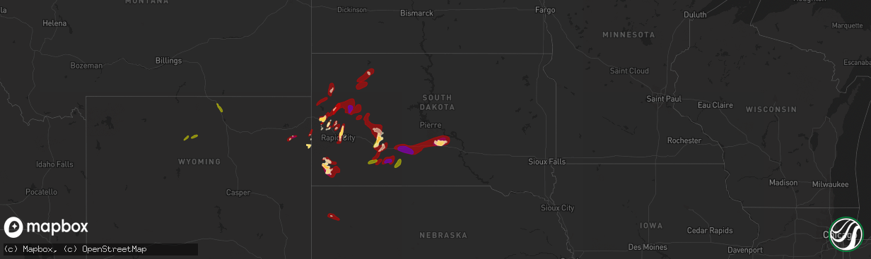
Hail Map in South Dakota on May 27, 2013
The weather event in South Dakota on May 27, 2013 includes Hail map. 8 states and 184 cities were impacted and suffered possible damage. The total estimated number of properties impacted is 2,861.
Want more than just the map?
Turn this storm into a full workflow.
- Owner + property data so you know who to knock
- OnDemand branded weather history reports to win the "did we even have hail?" argument
- RoofTrace estimate so reps stop guessing numbers at the door
Bought this map? Upgrade within 7 days and we'll credit the $230. (10-15 min setup call)
Hail
2,861
Estimated number of impacted properties by a 1.00" hail or larger20,317
Estimated number of impacted properties by a 1.75" hail or larger0
Estimated number of impacted properties by a 2.50" hail or largerStorm reports in South Dakota
South Dakota
| Date | Description |
|---|---|
| 05/27/20136:30 PM CDT | Nickel-sized hail also |
| 05/27/20135:50 PM CDT | 0.69 in of rain along with the hail |
| 05/27/20134:25 PM CDT | A local report indicates 1.00 inch wind near MEADOW |
| 05/27/20133:26 PM CDT | A local report indicates 1.50 inch wind near 5 S DOWNTOWN STURGIS |
| 05/27/20133:10 PM CDT | Mostly pea-sized with a few quarters |
| 05/27/20132:45 PM CDT | A local report indicates 1.00 inch wind near 4 ENE NEWELL |
| 05/27/20131:25 PM CDT | A local report indicates 1.00 inch wind near 6 W HOOVER |
| 05/27/201312:44 PM CDT | A local report indicates 1.75 inch wind near 1 ENE DEADWOOD |
| 05/27/201312:40 PM CDT | A local report indicates 1.00 inch wind near 2 SSW SAINT ONGE |
| 05/27/201311:25 AM CDT | A local report indicates 1.75 inch wind near 3 NNW ELLSWORTH AFB |
| 05/27/201312:00 AM CDT | A local report indicates 70 MPH wind near CHAMBERLAIN |
| 05/26/201311:55 PM CDT | A local report indicates 79 MPH wind near 2 W OACOMA |
| 05/26/201311:24 PM CDT | A local report indicates 62 MPH wind near WINNER |
| 05/26/201311:20 PM CDT | Wind stripped shingles and paper off roof heavy rain seeped through and destroyed the interior ceilings of home |
| 05/26/201311:05 PM CDT | Very strong winds accompaniied storm leaves are stripped from all the trees |
| 05/26/201310:57 PM CDT | Wind system at presho airport |
| 05/26/201310:57 PM CDT | Camper blown over and heating unit at school blown over. |
| 05/26/20139:40 PM CDT | A local report indicates 61 MPH wind near 10 NE BELVIDERE |
| 05/26/20138:40 PM CDT | A local report indicates 1.00 inch wind near 4 WSW WANBLEE |
| 05/26/20138:08 PM CDT | Hail mostly marble sized... But a few as large as quarters. |
| 05/26/20138:00 PM CDT | A local report indicates 1.75 inch wind near 10 SW DOWNTOWN HOT SPRI |
| 05/26/20137:31 PM CDT | A local report indicates 1.75 inch wind near 8 W DOWNTOWN HOT SPRING |
| 05/26/20137:20 PM CDT | A local report indicates 1.25 inch wind near 1 S PRINGLE |
All States Impacted by Hail Map on May 27, 2013
Cities Impacted by Hail Map on May 27, 2013
- Post, TX
- Dickens, TX
- Alma, NE
- Kadoka, SD
- Rapid City, SD
- Ellsworth Afb, SD
- Piedmont, SD
- Republican City, NE
- Webber, KS
- Formoso, KS
- Courtland, KS
- Jewell, KS
- Esbon, KS
- Burr Oak, KS
- Mankato, KS
- Philip, SD
- Mcadoo, TX
- Matador, TX
- Roaring Springs, TX
- Afton, TX
- Quinn, SD
- Whitewood, SD
- Sturgis, SD
- Newcastle, WY
- Box Elder, SD
- Childress, TX
- Kensington, KS
- Hot Springs, SD
- Spearfish, SD
- Saint Onge, SD
- Funk, NE
- Andrews, TX
- Sterling, CO
- Naponee, NE
- Upton, WY
- Moorcroft, WY
- Oakwood, OK
- Presho, SD
- Kennebec, SD
- Deadwood, SD
- Lead, SD
- Fort Meade, SD
- Paducah, TX
- Elm Creek, NE
- Holdrege, NE
- Oral, SD
- Belvidere, SD
- Foss, OK
- Canute, OK
- Dill City, OK
- Amherst, NE
- Kearney, NE
- Faith, SD
- Nemo, SD
- Stratton, CO
- Bethune, CO
- Bessie, OK
- Corn, OK
- Clinton, OK
- Milesville, SD
- Howes, SD
- Wall, SD
- Interior, SD
- Edgemont, SD
- Custer, SD
- Tell, TX
- Imperial, TX
- Sentinel, OK
- Rocky, OK
- Canton, OK
- Union Center, SD
- Weatherford, OK
- Wilcox, NE
- Mud Butte, SD
- Axtell, NE
- Wanblee, SD
- Buffalo Gap, SD
- Lower Brule, SD
- Cherry Creek, SD
- Cordell, OK
- Deweese, NE
- Lawrence, NE
- Fairfield, NE
- Glenvil, NE
- Blue Hill, NE
- Sundance, WY
- Belle Fourche, SD
- Fort Stockton, TX
- Newell, SD
- Odessa, NE
- Riverdale, NE
- Holcomb, KS
- Garden City, KS
- White Owl, SD
- Big Lake, TX
- Hemingford, NE
- Taloga, OK
- White River, SD
- Pringle, SD
- Carter, OK
- Superior, NE
- Floydada, TX
- Elk City, OK
- Meadow, SD
- Hardy, NE
- Enning, SD
- Dighton, KS
- Fleming, CO
- Peetz, CO
- Iliff, CO
- Padroni, CO
- New Underwood, SD
- Nisland, SD
- Buffalo, SD
- Vale, SD
- Bison, SD
- Lemmon, SD
- Wasta, SD
- Oelrichs, SD
- Smithwick, SD
- Kyle, SD
- Long Valley, SD
- Murdo, SD
- Draper, SD
- Vivian, SD
- Okaton, SD
- Maxwell, NE
- North Platte, NE
- Brady, NE
- Lodgepole, NE
- Sidney, NE
- Harrison, NE
- Geary, OK
- Lone Wolf, OK
- Vinson, OK
- Granite, OK
- Willow, OK
- Mangum, OK
- Cee Vee, TX
- Hollis, OK
- Crosbyton, TX
- Spur, TX
- Yuma, CO
- Akron, CO
- Otis, CO
- Cheyenne Wells, CO
- Arapahoe, CO
- Burlington, CO
- Hitchcock, OK
- Watonga, OK
- Putnam, OK
- Seiling, OK
- Custer City, OK
- Fay, OK
- Lebanon, KS
- Belleville, KS
- Scandia, KS
- Republic, KS
- Bloomington, NE
- Guide Rock, NE
- Chester, NE
- Hubbell, NE
- Hebron, NE
- Byron, NE
- Ruskin, NE
- Nelson, NE
- Deshler, NE
- Blue Rapids, KS
- Greenleaf, KS
- Palmer, KS
- Frankfort, KS
- Barnes, KS
- Waterville, KS
- Verdon, NE
- Fairfax, MO
- Rock Port, MO
- Shubert, NE
- Falls City, NE
- Nemaha, NE
- Worland, WY
- Banner, WY
- Sheridan, WY
- Tarzan, TX
- Marathon, TX


