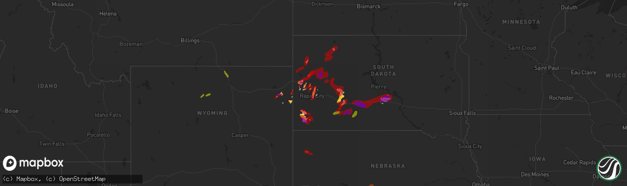
Hail Map on May 27, 2013
The weather event on May 27, 2013 includes Hail map. 8 states and 184 cities were impacted and suffered possible damage. The total estimated number of properties impacted is 38,727.
Want more than just the map?
Turn this storm into a full workflow.
- Owner + property data so you know who to knock
- OnDemand branded weather history reports to win the "did we even have hail?" argument
- RoofTrace estimate so reps stop guessing numbers at the door
Bought this map? Upgrade within 7 days and we'll credit the $230. (10-15 min setup call)
Hail
38,727
Estimated number of impacted properties by a 1.00" hail or larger34,383
Estimated number of impacted properties by a 1.75" hail or larger3,708
Estimated number of impacted properties by a 2.50" hail or largerStates Impacted by Hail Map on May 27, 2013
Storm reports
Texas
| Date | Description |
|---|---|
| 05/27/20136:30 PM CDT | A local report indicates 1.00 inch wind near 3 E AFTON |
| 05/27/20136:26 PM CDT | A local report indicates 1.75 inch wind near POST |
| 05/27/20136:10 PM CDT | Wind gusts estimated at 50-60 mph |
| 05/27/20136:10 PM CDT | A local report indicates 1.75 inch wind near 5 N DICKENS |
| 05/27/20135:50 PM CDT | Hail mostly quarter size with a few as large as golf balls |
| 05/27/20135:46 PM CDT | A local report indicates 1.00 inch wind near 14 N DICKENS |
| 05/27/20135:45 PM CDT | Relayed report of up to baseball size hail |
| 05/27/20135:45 PM CDT | Nickel to golf ball size hail in town |
South Dakota
| Date | Description |
|---|---|
| 05/27/20136:30 PM CDT | Nickel-sized hail also |
| 05/27/20135:50 PM CDT | 0.69 in of rain along with the hail |
| 05/27/20134:25 PM CDT | A local report indicates 1.00 inch wind near MEADOW |
| 05/27/20133:26 PM CDT | A local report indicates 1.50 inch wind near 5 S DOWNTOWN STURGIS |
| 05/27/20133:10 PM CDT | Mostly pea-sized with a few quarters |
| 05/27/20132:45 PM CDT | A local report indicates 1.00 inch wind near 4 ENE NEWELL |
| 05/27/20131:25 PM CDT | A local report indicates 1.00 inch wind near 6 W HOOVER |
| 05/27/201312:44 PM CDT | A local report indicates 1.75 inch wind near 1 ENE DEADWOOD |
| 05/27/201312:40 PM CDT | A local report indicates 1.00 inch wind near 2 SSW SAINT ONGE |
| 05/27/201311:25 AM CDT | A local report indicates 1.75 inch wind near 3 NNW ELLSWORTH AFB |
| 05/27/201312:00 AM CDT | A local report indicates 70 MPH wind near CHAMBERLAIN |
| 05/26/201311:55 PM CDT | A local report indicates 79 MPH wind near 2 W OACOMA |
| 05/26/201311:24 PM CDT | A local report indicates 62 MPH wind near WINNER |
| 05/26/201311:20 PM CDT | Wind stripped shingles and paper off roof heavy rain seeped through and destroyed the interior ceilings of home |
| 05/26/201311:05 PM CDT | Very strong winds accompaniied storm leaves are stripped from all the trees |
| 05/26/201310:57 PM CDT | Camper blown over and heating unit at school blown over. |
| 05/26/201310:57 PM CDT | Wind system at presho airport |
| 05/26/20139:40 PM CDT | A local report indicates 61 MPH wind near 10 NE BELVIDERE |
| 05/26/20138:40 PM CDT | A local report indicates 1.00 inch wind near 4 WSW WANBLEE |
| 05/26/20138:08 PM CDT | Hail mostly marble sized... But a few as large as quarters. |
| 05/26/20138:00 PM CDT | A local report indicates 1.75 inch wind near 10 SW DOWNTOWN HOT SPRI |
| 05/26/20137:31 PM CDT | A local report indicates 1.75 inch wind near 8 W DOWNTOWN HOT SPRING |
| 05/26/20137:20 PM CDT | A local report indicates 1.25 inch wind near 1 S PRINGLE |
Oklahoma
| Date | Description |
|---|---|
| 05/27/20136:58 PM CDT | A local report indicates 60 MPH wind near SAYRE |
| 05/27/20136:55 PM CDT | A local report indicates 58 MPH wind near 4 ESE ERICK |
| 05/27/20136:50 PM CDT | A local report indicates 60 MPH wind near 4 ESE ERICK |
| 05/27/20136:45 PM CDT | A local report indicates 65 MPH wind near 4 ESE ERICK |
| 05/27/20136:33 PM CDT | A local report indicates 1.00 inch wind near REED |
| 05/27/20136:30 PM CDT | A local report indicates 70 MPH wind near 7 N REED |
| 05/26/20138:12 PM CDT | Quarter to half dollar sized hail at the oakwood fire dept. |
| 05/26/20137:55 PM CDT | A local report indicates 78 MPH wind near 2 NE CLINTON |
| 05/26/20137:42 PM CDT | Minor damage to a hangar at clk airpark. Time est. |
| 05/26/20137:42 PM CDT | Two trees around 10 inches in diameter were snapped. Time est. |
| 05/26/20137:42 PM CDT | 5 power poles down 1 mi north of i40 near exit 71. |
| 05/26/20137:40 PM CDT | A local report indicates 1.75 inch wind near 3 N BESSIE |
| 05/26/20137:36 PM CDT | A 60x30 ft metal roof was removed from the whitedog hill restaurant near i40 mile marker 70. A billboard was also damaged near this location. Time est. |
| 05/26/20137:26 PM CDT | A local report indicates 1.25 inch wind near 3 E BURNS FLAT |
| 05/26/20137:22 PM CDT | A local report indicates 1.75 inch wind near BURNS FLAT |
| 05/26/20137:18 PM CDT | A local report indicates 70 MPH wind near 4 ENE CLINTON |
| 05/26/20137:18 PM CDT | Measured by clinton-sherman asos |
| 05/26/20137:17 PM CDT | A local report indicates 1.75 inch wind near 6 W DILL CITY |
| 05/26/20137:15 PM CDT | Roof blown off of barn southwest of canute. |
| 05/26/20137:10 PM CDT | A local report indicates 64 MPH wind near 6 SW CHEYENNE |
Colorado
| Date | Description |
|---|---|
| 05/27/20136:58 PM CDT | A local report indicates 1.00 inch wind near 1 E REIRADON HILL |
| 05/27/20136:33 PM CDT | A local report indicates 1.50 inch wind near STERLING |
| 05/27/20136:27 PM CDT | A local report indicates 1.25 inch wind near NW STERLING |
| 05/27/20135:45 PM CDT | Landspout observed on storm chaser streaming video. |
| 05/27/20135:20 PM CDT | A local report indicates 60 MPH wind near WSW PEETZ |
| 05/27/20135:15 PM CDT | Time estimated by radar. |
| 05/27/20134:54 PM CDT | Landspout reported approximately 15 miles northeast of cheyenne wells. |
| 05/27/20134:52 PM CDT | A local report indicates 1.00 inch wind near 9 W PEETZ |
| 05/27/20134:45 PM CDT | A local report indicates 1.00 inch wind near NNW PEETZ |
| 05/27/20133:54 PM CDT | One inch diameter hail found on the ground at county road 43 and county road g. Time estimated by radar. |
| 05/27/20133:05 PM CDT | A local report indicates 1.25 inch wind near 7 S STRATTON |
Illinois
| Date | Description |
|---|---|
| 05/27/20134:00 PM CDT | Large tree down. Relayed via wcia facebook page |
| 05/27/20133:52 PM CDT | Large tree branch snapped off. Relayed via wand facebook page |
| 05/27/20133:35 PM CDT | A local report indicates 61 MPH wind near DECATUR |
| 05/27/20133:35 PM CDT | Multiple tree limbs down on regal avenue. Time estimated. |
| 05/27/20133:34 PM CDT | Large tree snapped off low at the base. Relayed via wand facebook page |
| 05/27/20133:33 PM CDT | Windows blown out at best buy. Piece of roof torn off lowes. Relayed via wand and public posting on facebook |
| 05/27/20133:20 PM CDT | Power poles and power lines down. Machine shed roof torn off. Late report. |
| 05/27/20133:16 PM CDT | Large tree down on a truck. Relayed via wand and public posting on facebook |
| 05/27/20133:15 PM CDT | Large tree snapped at the base. Received on wand facebook page |
| 05/27/20133:00 PM CDT | Additional updated information at 625 pm from county oem official...damage occurred at lincoln place mobile home park...located at 1236 oak lane road. 48 mobile homes w |
| 05/27/20133:00 PM CDT | 3 trees down in town. Late report. |
| 05/27/20132:58 PM CDT | A local report indicates 65 MPH wind near ROCHESTER |
| 05/27/20132:55 PM CDT | Numerous large trees down along west lake dr. And near hanson robinson zoo. Swop report. |
| 05/27/20132:55 PM CDT | Estimated 50 to 60 mph downtown. |
| 05/27/20132:55 PM CDT | Tree blown down near brenden gardens retirment home. Public report. |
| 05/27/20132:54 PM CDT | Tree limb down. Power pole snapped. Reported via wics facebook page |
| 05/27/20132:53 PM CDT | Report of shingle damage to multiple homes. |
| 05/27/20132:52 PM CDT | Large tree limbs down on reservoir street. Relayed via wics facebook page |
| 05/27/20132:48 PM CDT | Shed destroyed near the intersection of ash and macarthur. Relayed via wand facebook page |
| 05/27/20132:47 PM CDT | Tree down near krell drive. |
| 05/27/20132:45 PM CDT | Large tree limbs blown down. |
| 05/27/20132:43 PM CDT | Tree branch snapped off. Relayed via wics facebook page |
| 05/27/20132:37 PM CDT | 3 foot diameter tree blon down at route 4 and curran rd. |
Nebraska
| Date | Description |
|---|---|
| 05/27/20136:30 PM CDT | Few golf balls mixed with slightly smaller hail. |
| 05/27/20136:22 PM CDT | A local report indicates 1.00 inch wind near 8 SE CRAWFORD |
| 05/27/20136:20 PM CDT | A few quarters mixed in with mostly nickels. |
| 05/27/20135:55 PM CDT | Ongoing. |
| 05/27/20135:47 PM CDT | Hail up to quarter size...most smaller |
| 05/27/20135:37 PM CDT | A local report indicates 1.75 inch wind near 5 S ODESSA |
| 05/27/20135:26 PM CDT | A local report indicates 1.50 inch wind near 6 NW FUNK |
| 05/27/20135:20 PM CDT | Half inch to quarter sized hail. Grass is covered with hail. 0.5 inches of new rainfall. |
| 05/27/20135:05 PM CDT | A local report indicates a tornado near 18 W HEMINGFORD |
| 05/27/20134:55 PM CDT | A few stones up to quarter size |
| 05/27/20134:53 PM CDT | A local report indicates 1.00 inch wind near SIDNEY |
| 05/27/20134:50 PM CDT | And rain over an inch. |
| 05/27/20134:44 PM CDT | Law enforcement reported a tornado on the ground 15 to 20 miles southeast of harrison. Reporter was on highway 71 looking south. |
| 05/27/20133:28 PM CDT | Tornado has now lifted. |
| 05/27/20133:25 PM CDT | Relayed via kimball warning point. Deputy has visual on tornado. |
| 05/27/20133:15 PM CDT | Spotter reports two tornadoes on the ground. |
| 05/27/20133:05 PM CDT | Several reports relayed by kimball warning point as well. |
| 05/26/201311:03 PM CDT | A local report indicates 58 MPH wind near FALLS CITY |
| 05/26/201311:00 PM CDT | Power lines downed. |
| 05/26/20139:25 PM CDT | A local report indicates 60 MPH wind near BEATRICE |
| 05/26/20139:04 PM CDT | Possible tornado. Buildings damaged. Deputies reported power lines down and boards impaled in buildings on highway 103 between 713 and 714 road. Time estimated by radar |
| 05/26/20138:30 PM CDT | Five inch tree limbs down...gas station sign blown over...grain elevator spouts bent. |
| 05/26/20138:30 PM CDT | A local report indicates 70 MPH wind near 2 N STRANG |
| 05/26/20138:22 PM CDT | 2 grain bins blown down by ball fields. Time estimated from radar data. |
| 05/26/20138:20 PM CDT | A local report indicates 1.00 inch wind near NORTH PLATTE |
| 05/26/20138:10 PM CDT | A local report indicates 60 MPH wind near 2 W CARLETON |
| 05/26/20138:00 PM CDT | A local report indicates 78 MPH wind near 2 NNE DAVENPORT |
| 05/26/20138:00 PM CDT | Uprooted trees and damaged chicken house reported in extreme southwest fillmore county along road y. Time estimated from radar. |
| 05/26/20137:59 PM CDT | Corrected to measured instead of estimated |
| 05/26/20137:35 PM CDT | Report of downed power lines and overturned pivots in the edgar area. Time estimated from radar data. |
| 05/26/20137:35 PM CDT | A local report indicates 58 MPH wind near 1 W OGALLALA |
| 05/26/20137:32 PM CDT | Brief tornado reported just west of edgar |
| 05/26/20137:32 PM CDT | A local report indicates 74 MPH wind near 8 ESE AYR |
| 05/26/20137:30 PM CDT | Estimated 50-60 mph winds at hwy 14 and edgar spur |
| 05/26/20137:16 PM CDT | Time corrected from original 732 pm |
Wyoming
| Date | Description |
|---|---|
| 05/27/20135:45 PM CDT | A local report indicates 1.75 inch wind near DOWNTOWN NEWCASTLE |
| 05/27/20135:43 PM CDT | A local report indicates 1.50 inch wind near 1 WSW DOWNTOWN NEWCASTL |
| 05/27/20135:18 PM CDT | Max hail size 2 inches. Mostly golfball size. |
| 05/27/20134:55 PM CDT | A local report indicates 1.25 inch wind near UPTON |
| 05/27/20133:00 PM CDT | Numerous reports of hail ranging from the size of peas to quarters in and around sheridan beginning at 200 pm and continuing until around 215 pm. |
| 05/27/20132:36 PM CDT | A few quarter size hail stones fell. The rest were smaller and slushy. |
| 05/27/20132:00 PM CDT | Largest hail one inch in diameter. Average hail size one half inch. |
| 05/27/201311:58 AM CDT | Tornado lifted back up into the cloud by 1119am |
Kansas
| Date | Description |
|---|---|
| 05/27/20136:50 PM CDT | Weak tornado on the ground for approximately 5-6 minutes 3 miles north of highway 36 ending at 650 cdt. |
| 05/27/20136:46 PM CDT | A local report indicates 1.00 inch wind near 3 NE SMITH CENTER |
| 05/27/20136:29 PM CDT | Weak tornado with brief touchdown reported approximately 3-4 miles northwest of smith center. Lasted for less than one minute. |
| 05/27/20136:04 PM CDT | Estimated in rear flank downdraft area of storm |
| 05/26/20139:42 PM CDT | Damage to john deere dealership |
| 05/26/20139:40 PM CDT | A local report indicates a tornado near 1 NW MARYSVILLE |
| 05/26/20139:40 PM CDT | A local report indicates a tornado near 2 W MARYSVILLE |
| 05/26/20138:36 PM CDT | Tennis ball sized hail lasted 3-4 minutes and ended at approximately 833 pm cdt. Golf ball sized hail still ongoing. |
| 05/26/20138:30 PM CDT | 2.25 inch hail reported by media. |
| 05/26/20138:25 PM CDT | Largest hail stone measured 5.25 inches. Numerous stones 3.5 to 4 inches. |
| 05/26/20138:24 PM CDT | A local report indicates 2.00 inch wind near MANKATO |
| 05/26/20138:10 PM CDT | A local report indicates 2.50 inch wind near MANKATO |
| 05/26/20138:10 PM CDT | Measured 2.1 hail at 810 pm cdt. |
| 05/26/20138:02 PM CDT | Ongoing. |
| 05/26/20137:48 PM CDT | A local report indicates 1.00 inch wind near 6 N ESBON |
| 05/26/20137:32 PM CDT | A local report indicates 1.00 inch wind near 4 WNW BELOIT |
| 05/26/20137:15 PM CDT | Three houses were damaged from about 4 miles northwest of esbon to about 2 miles north northeast of esbon. |
| 05/26/20137:10 PM CDT | Delayed report of large tornado at least one-half mile wide...from social media post. Time aided by radar estimation. No known damage at this time. |
Indiana
| Date | Description |
|---|---|
| 05/27/20135:08 PM CDT | Report relayed by ema. Three power poles broken and several others leaning. One or more poles described as being major poles. Located at 500 west and 1000 north. |
| 05/27/20134:45 PM CDT | Report relayed by ema. Three power poles broken and several others leaning. One or more poles described as being major poles. Located at 500 west and 1000 north. |
| 05/27/20134:35 PM CDT | Utility poles down in downtown by hospital at sr 9 and sr 28. Sr 9 will be closed due to sparking lines on the road and poles leaning into roadway. Time estimated from |
Missouri
| Date | Description |
|---|---|
| 05/27/20132:38 AM CDT | A local report indicates 66 MPH wind near 5 S KIRKSVILLE |
| 05/26/201311:35 PM CDT | Delayed report. Winds estimated at 60 to 65 mph causing 3 willow and cottonwood tree trunks about 10 to 12 inches in diameter to snap. |
| 05/26/201311:18 PM CDT | Power outage in fairfax. |
| 05/26/201311:14 PM CDT | Lasted between 5-10 minutes. |
| 05/26/201311:10 PM CDT | Tree uprooted and buildings damaged. |
| 05/26/201310:51 PM CDT | Reported west of fairfax. |
Cities Impacted by Hail Map on May 27, 2013
- Post, TX
- Dickens, TX
- Alma, NE
- Kadoka, SD
- Rapid City, SD
- Ellsworth Afb, SD
- Piedmont, SD
- Republican City, NE
- Webber, KS
- Formoso, KS
- Courtland, KS
- Jewell, KS
- Esbon, KS
- Burr Oak, KS
- Mankato, KS
- Philip, SD
- Mcadoo, TX
- Matador, TX
- Roaring Springs, TX
- Afton, TX
- Quinn, SD
- Whitewood, SD
- Sturgis, SD
- Newcastle, WY
- Box Elder, SD
- Childress, TX
- Kensington, KS
- Hot Springs, SD
- Spearfish, SD
- Saint Onge, SD
- Funk, NE
- Andrews, TX
- Sterling, CO
- Naponee, NE
- Upton, WY
- Moorcroft, WY
- Oakwood, OK
- Presho, SD
- Kennebec, SD
- Deadwood, SD
- Lead, SD
- Fort Meade, SD
- Paducah, TX
- Elm Creek, NE
- Holdrege, NE
- Oral, SD
- Belvidere, SD
- Foss, OK
- Canute, OK
- Dill City, OK
- Amherst, NE
- Kearney, NE
- Faith, SD
- Nemo, SD
- Stratton, CO
- Bethune, CO
- Bessie, OK
- Corn, OK
- Clinton, OK
- Milesville, SD
- Howes, SD
- Wall, SD
- Interior, SD
- Edgemont, SD
- Custer, SD
- Tell, TX
- Imperial, TX
- Sentinel, OK
- Rocky, OK
- Canton, OK
- Union Center, SD
- Weatherford, OK
- Wilcox, NE
- Mud Butte, SD
- Axtell, NE
- Wanblee, SD
- Buffalo Gap, SD
- Lower Brule, SD
- Cherry Creek, SD
- Cordell, OK
- Deweese, NE
- Lawrence, NE
- Fairfield, NE
- Glenvil, NE
- Blue Hill, NE
- Sundance, WY
- Belle Fourche, SD
- Fort Stockton, TX
- Newell, SD
- Odessa, NE
- Riverdale, NE
- Holcomb, KS
- Garden City, KS
- White Owl, SD
- Big Lake, TX
- Hemingford, NE
- Taloga, OK
- White River, SD
- Pringle, SD
- Carter, OK
- Superior, NE
- Floydada, TX
- Elk City, OK
- Meadow, SD
- Hardy, NE
- Enning, SD
- Dighton, KS
- Fleming, CO
- Peetz, CO
- Iliff, CO
- Padroni, CO
- New Underwood, SD
- Nisland, SD
- Buffalo, SD
- Vale, SD
- Bison, SD
- Lemmon, SD
- Wasta, SD
- Oelrichs, SD
- Smithwick, SD
- Kyle, SD
- Long Valley, SD
- Murdo, SD
- Draper, SD
- Vivian, SD
- Okaton, SD
- Maxwell, NE
- North Platte, NE
- Brady, NE
- Lodgepole, NE
- Sidney, NE
- Harrison, NE
- Geary, OK
- Lone Wolf, OK
- Vinson, OK
- Granite, OK
- Willow, OK
- Mangum, OK
- Cee Vee, TX
- Hollis, OK
- Crosbyton, TX
- Spur, TX
- Yuma, CO
- Akron, CO
- Otis, CO
- Cheyenne Wells, CO
- Arapahoe, CO
- Burlington, CO
- Hitchcock, OK
- Watonga, OK
- Putnam, OK
- Seiling, OK
- Custer City, OK
- Fay, OK
- Lebanon, KS
- Belleville, KS
- Scandia, KS
- Republic, KS
- Bloomington, NE
- Guide Rock, NE
- Chester, NE
- Hubbell, NE
- Hebron, NE
- Byron, NE
- Ruskin, NE
- Nelson, NE
- Deshler, NE
- Blue Rapids, KS
- Greenleaf, KS
- Palmer, KS
- Frankfort, KS
- Barnes, KS
- Waterville, KS
- Verdon, NE
- Fairfax, MO
- Rock Port, MO
- Shubert, NE
- Falls City, NE
- Nemaha, NE
- Worland, WY
- Banner, WY
- Sheridan, WY
- Tarzan, TX
- Marathon, TX