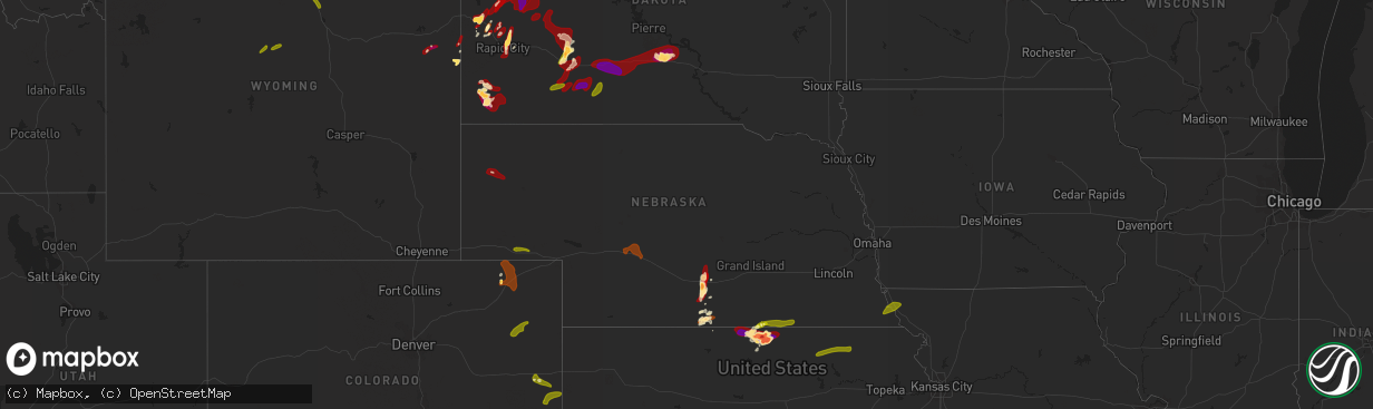
Hail Map in Nebraska on May 27, 2013
The weather event in Nebraska on May 27, 2013 includes Hail map. 8 states and 184 cities were impacted and suffered possible damage. The total estimated number of properties impacted is 13,935.
Want more than just the map?
Turn this storm into a full workflow.
- Owner + property data so you know who to knock
- OnDemand branded weather history reports to win the "did we even have hail?" argument
- RoofTrace estimate so reps stop guessing numbers at the door
Bought this map? Upgrade within 7 days and we'll credit the $230. (10-15 min setup call)
Hail
13,935
Estimated number of impacted properties by a 1.00" hail or larger2,727
Estimated number of impacted properties by a 1.75" hail or larger0
Estimated number of impacted properties by a 2.50" hail or largerStorm reports in Nebraska
Nebraska
| Date | Description |
|---|---|
| 05/27/20136:30 PM CDT | Few golf balls mixed with slightly smaller hail. |
| 05/27/20136:22 PM CDT | A local report indicates 1.00 inch wind near 8 SE CRAWFORD |
| 05/27/20136:20 PM CDT | A few quarters mixed in with mostly nickels. |
| 05/27/20135:55 PM CDT | Ongoing. |
| 05/27/20135:47 PM CDT | Hail up to quarter size...most smaller |
| 05/27/20135:37 PM CDT | A local report indicates 1.75 inch wind near 5 S ODESSA |
| 05/27/20135:26 PM CDT | A local report indicates 1.50 inch wind near 6 NW FUNK |
| 05/27/20135:20 PM CDT | Half inch to quarter sized hail. Grass is covered with hail. 0.5 inches of new rainfall. |
| 05/27/20135:05 PM CDT | A local report indicates a tornado near 18 W HEMINGFORD |
| 05/27/20134:55 PM CDT | A few stones up to quarter size |
| 05/27/20134:53 PM CDT | A local report indicates 1.00 inch wind near SIDNEY |
| 05/27/20134:50 PM CDT | And rain over an inch. |
| 05/27/20134:44 PM CDT | Law enforcement reported a tornado on the ground 15 to 20 miles southeast of harrison. Reporter was on highway 71 looking south. |
| 05/27/20133:28 PM CDT | Tornado has now lifted. |
| 05/27/20133:25 PM CDT | Relayed via kimball warning point. Deputy has visual on tornado. |
| 05/27/20133:15 PM CDT | Spotter reports two tornadoes on the ground. |
| 05/27/20133:05 PM CDT | Several reports relayed by kimball warning point as well. |
| 05/26/201311:03 PM CDT | A local report indicates 58 MPH wind near FALLS CITY |
| 05/26/201311:00 PM CDT | Power lines downed. |
| 05/26/20139:25 PM CDT | A local report indicates 60 MPH wind near BEATRICE |
| 05/26/20139:04 PM CDT | Possible tornado. Buildings damaged. Deputies reported power lines down and boards impaled in buildings on highway 103 between 713 and 714 road. Time estimated by radar |
| 05/26/20138:30 PM CDT | A local report indicates 70 MPH wind near 2 N STRANG |
| 05/26/20138:30 PM CDT | Five inch tree limbs down...gas station sign blown over...grain elevator spouts bent. |
| 05/26/20138:22 PM CDT | 2 grain bins blown down by ball fields. Time estimated from radar data. |
| 05/26/20138:20 PM CDT | A local report indicates 1.00 inch wind near NORTH PLATTE |
| 05/26/20138:10 PM CDT | A local report indicates 60 MPH wind near 2 W CARLETON |
| 05/26/20138:00 PM CDT | Uprooted trees and damaged chicken house reported in extreme southwest fillmore county along road y. Time estimated from radar. |
| 05/26/20138:00 PM CDT | A local report indicates 78 MPH wind near 2 NNE DAVENPORT |
| 05/26/20137:59 PM CDT | Corrected to measured instead of estimated |
| 05/26/20137:35 PM CDT | A local report indicates 58 MPH wind near 1 W OGALLALA |
| 05/26/20137:35 PM CDT | Report of downed power lines and overturned pivots in the edgar area. Time estimated from radar data. |
| 05/26/20137:32 PM CDT | A local report indicates 74 MPH wind near 8 ESE AYR |
| 05/26/20137:32 PM CDT | Brief tornado reported just west of edgar |
| 05/26/20137:30 PM CDT | Estimated 50-60 mph winds at hwy 14 and edgar spur |
| 05/26/20137:16 PM CDT | Time corrected from original 732 pm |
All States Impacted by Hail Map on May 27, 2013
Cities Impacted by Hail Map on May 27, 2013
- Post, TX
- Dickens, TX
- Alma, NE
- Kadoka, SD
- Rapid City, SD
- Ellsworth Afb, SD
- Piedmont, SD
- Republican City, NE
- Webber, KS
- Formoso, KS
- Courtland, KS
- Jewell, KS
- Esbon, KS
- Burr Oak, KS
- Mankato, KS
- Philip, SD
- Mcadoo, TX
- Matador, TX
- Roaring Springs, TX
- Afton, TX
- Quinn, SD
- Whitewood, SD
- Sturgis, SD
- Newcastle, WY
- Box Elder, SD
- Childress, TX
- Kensington, KS
- Hot Springs, SD
- Spearfish, SD
- Saint Onge, SD
- Funk, NE
- Andrews, TX
- Sterling, CO
- Naponee, NE
- Upton, WY
- Moorcroft, WY
- Oakwood, OK
- Presho, SD
- Kennebec, SD
- Deadwood, SD
- Lead, SD
- Fort Meade, SD
- Paducah, TX
- Elm Creek, NE
- Holdrege, NE
- Oral, SD
- Belvidere, SD
- Foss, OK
- Canute, OK
- Dill City, OK
- Amherst, NE
- Kearney, NE
- Faith, SD
- Nemo, SD
- Stratton, CO
- Bethune, CO
- Bessie, OK
- Corn, OK
- Clinton, OK
- Milesville, SD
- Howes, SD
- Wall, SD
- Interior, SD
- Edgemont, SD
- Custer, SD
- Tell, TX
- Imperial, TX
- Sentinel, OK
- Rocky, OK
- Canton, OK
- Union Center, SD
- Weatherford, OK
- Wilcox, NE
- Mud Butte, SD
- Axtell, NE
- Wanblee, SD
- Buffalo Gap, SD
- Lower Brule, SD
- Cherry Creek, SD
- Cordell, OK
- Deweese, NE
- Lawrence, NE
- Fairfield, NE
- Glenvil, NE
- Blue Hill, NE
- Sundance, WY
- Belle Fourche, SD
- Fort Stockton, TX
- Newell, SD
- Odessa, NE
- Riverdale, NE
- Holcomb, KS
- Garden City, KS
- White Owl, SD
- Big Lake, TX
- Hemingford, NE
- Taloga, OK
- White River, SD
- Pringle, SD
- Carter, OK
- Superior, NE
- Floydada, TX
- Elk City, OK
- Meadow, SD
- Hardy, NE
- Enning, SD
- Dighton, KS
- Fleming, CO
- Peetz, CO
- Iliff, CO
- Padroni, CO
- New Underwood, SD
- Nisland, SD
- Buffalo, SD
- Vale, SD
- Bison, SD
- Lemmon, SD
- Wasta, SD
- Oelrichs, SD
- Smithwick, SD
- Kyle, SD
- Long Valley, SD
- Murdo, SD
- Draper, SD
- Vivian, SD
- Okaton, SD
- Maxwell, NE
- North Platte, NE
- Brady, NE
- Lodgepole, NE
- Sidney, NE
- Harrison, NE
- Geary, OK
- Lone Wolf, OK
- Vinson, OK
- Granite, OK
- Willow, OK
- Mangum, OK
- Cee Vee, TX
- Hollis, OK
- Crosbyton, TX
- Spur, TX
- Yuma, CO
- Akron, CO
- Otis, CO
- Cheyenne Wells, CO
- Arapahoe, CO
- Burlington, CO
- Hitchcock, OK
- Watonga, OK
- Putnam, OK
- Seiling, OK
- Custer City, OK
- Fay, OK
- Lebanon, KS
- Belleville, KS
- Scandia, KS
- Republic, KS
- Bloomington, NE
- Guide Rock, NE
- Chester, NE
- Hubbell, NE
- Hebron, NE
- Byron, NE
- Ruskin, NE
- Nelson, NE
- Deshler, NE
- Blue Rapids, KS
- Greenleaf, KS
- Palmer, KS
- Frankfort, KS
- Barnes, KS
- Waterville, KS
- Verdon, NE
- Fairfax, MO
- Rock Port, MO
- Shubert, NE
- Falls City, NE
- Nemaha, NE
- Worland, WY
- Banner, WY
- Sheridan, WY
- Tarzan, TX
- Marathon, TX


