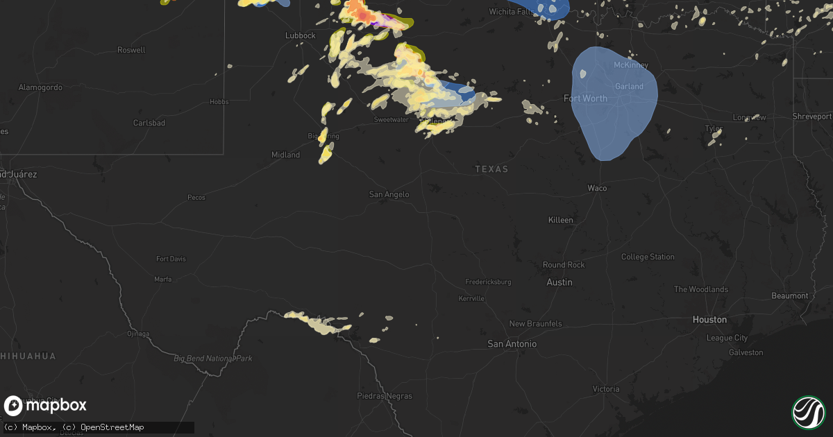
Hail Map in Texas on May 25, 2025
Get this storm
May 25 map
$229
one time, instant access
Download today. No call, no setup
Keep the $229
Bought the map and want the full workflow? Apply the entire $229 to a subscription within 7 days. None of it is wasted.
Every map, not just this one
This buys you this map. Subscription and you get every map we run, in the markets you choose from a few cities to whole states to nationwide. Plus real-time alerts the moment a storm fires.
Contact data
Name, contact info, occupancy, even credit band for addresses in the footprint. You go from where it hit to who to call.
Become the source they trust
Unlimited branding weather history reports on demand. You already have the documented answer ready for the property owner, and you are the one who showed up with it.
Property data and RoofTrace estimates
Pull up any address you have got, its value and the exact code rules for that jurisdiction, straight from One Click Code. Then RoofTrace estimates the squares, pitch, and roof value, priced the way you price.
Storm reports in Texas
Texas
| Date | Description |
|---|---|
| 05/25/20256:53 PM CDT | Report from mping: quarter |
| 05/25/20256:40 PM CDT | Report from mping: ping pong ball |
| 05/25/20256:35 PM CDT | Social media picture. |
| 05/25/20256:28 PM CDT | A local report indicates 1.00 inch wind near 4 E Mackenzie Reservoir |
| 05/25/20256:21 PM CDT | Report of multiple downed powerlines. |
| 05/25/20256:19 PM CDT | Report from mping: golf ball |
| 05/25/20256:17 PM CDT | A local report indicates 1.50 inch wind near 2 SW Big Spring |
| 05/25/20256:13 PM CDT | A local report indicates 1.75 inch wind near 3 NW Elbow |
| 05/25/20256:04 PM CDT | Power poles broken along us-83. Time and location estimated from radar. |
| 05/25/20256:04 PM CDT | A local report indicates 66 MPH wind near 3 NE Aspermont |
| 05/25/20255:59 PM CDT | A local report indicates 65 MPH wind near 3 NE Aspermont |
| 05/25/20255:58 PM CDT | Social media picture. |
| 05/25/20255:24 PM CDT | Report from mping: grapefruit |
| 05/25/20255:17 PM CDT | Gr2 report. |
| 05/25/20255:12 PM CDT | Icechip report. |
| 05/25/20255:09 PM CDT | Social media picture. |
| 05/25/20255:07 PM CDT | Icechip report. |
| 05/25/20255:04 PM CDT | Icechip report. |
| 05/25/20254:56 PM CDT | Report from mping: grapefruit |
| 05/25/20254:53 PM CDT | Picture posted on social media. |
| 05/25/20254:52 PM CDT | Icechip report. Hail found on roadside after storm. Time estimated from radar. |
| 05/25/20254:52 PM CDT | Report from mping: baseball++ |
| 05/25/20254:50 PM CDT | Report from mping: baseball+ |
| 05/25/20254:49 PM CDT | Corrects time of previous hail report from 2 nne afton. Social media picture. |
| 05/25/20254:46 PM CDT | Report from mping: golf ball |
| 05/25/20254:45 PM CDT | Corrects time of previous hail report from afton. Report from mping: grapefruit |
| 05/25/20254:40 PM CDT | Icechip report. Hail found on roadside after storm. Time estimated from radar. |
| 05/25/20254:40 PM CDT | Icechip report. Hail found on roadside after storm. Time estimated from radar. |
| 05/25/20254:38 PM CDT | Partially melted hailstone about the size of a ballcap. Time estimated from radar. |
| 05/25/20254:32 PM CDT | A local report indicates 1.75 inch wind near Roaring Springs |
| 05/25/20254:26 PM CDT | Icechip report. |
| 05/25/20254:15 PM CDT | A local report indicates 1.50 inch wind near 1 NE Matador |
| 05/25/20254:09 PM CDT | Icechip report. |
| 05/25/20254:04 PM CDT | Report from mping: ping pong ball |
| 05/25/20254:02 PM CDT | Report from mping: quarter |
| 05/25/20253:49 PM CDT | Icechip report. |
| 05/25/20253:49 PM CDT | Report from mping: tennis ball |
| 05/25/20253:47 PM CDT | Report from mping: hen egg |
| 05/25/20253:43 PM CDT | Report from mping: baseball |
| 05/25/20253:24 PM CDT | Icechip report. |
| 05/25/20253:11 PM CDT | Report from mping: hen egg |
| 05/25/20253:10 PM CDT | Icechip report. |
| 05/25/20253:10 PM CDT | A local report indicates 1.00 inch wind near 7 WSW Matador |
| 05/25/20253:05 PM CDT | Report from mping: hen egg |
| 05/25/20253:04 PM CDT | Report from mping: tea cup |
| 05/25/20253:04 PM CDT | Corrects previous hail report from 6 ene dougherty. Icechip report. |
| 05/25/20252:28 PM CDT | A local report indicates 1.00 inch wind near 9 SE Flomot |
| 05/25/20252:11 PM CDT | A local report indicates 1.50 inch wind near 9 NW Matador |
| 05/25/20252:08 PM CDT | Report from mping: ping pong ball |
| 05/25/20252:07 PM CDT | Report from mping: quarter |
| 05/25/20256:43 AM CDT | Flooding near intersection of us highway 271 and loop 323. Report of car stuck in flood waters. |
| 05/25/20256:43 AM CDT | Flooding ne |
| 05/25/20256:43 AM CDT | Flooding near inters |
| 05/25/20256:29 AM CDT | Report of tree down across both lanes on old palestine rd near the gresham community. (sh |
| 05/25/20256:29 AM CDT | Report of tree down across both lanes on old palestine rd near the gresham community. |
| 05/25/20256:25 AM CDT | Widespread reports of trees and powerlines down across the county. |
| 05/25/20256:15 AM CDT | Tree across the road on county road 115 in southern smith county. |
| 05/25/20256:09 AM CDT | Delayed report. Shiloh vfd reported downed tree blocking roadway on lcr 456 just before the railroad. Time estimated via radar. |
| 05/25/20256:09 AM CDT | Delayed report. Shiloh vfd reported downed tree blocking roadway on lcr 456 just before the railroad. Time |
| 05/25/20255:25 AM CDT | Delayed report. Tree damage reported in the lake kiowa community. Time estimated via radar. |
| 05/25/20255:13 AM CDT | Multiple trees down on top of powerlines near the intersection of county road 129 and fm road 756 in the antioch community. |
| 05/25/20254:50 AM CDT | Trained spotter reports measured 62 mph wind gust near the juniper cove marina. |
| 05/25/20253:05 AM CDT | Arlington airport gusted to 58 mph. |
| 05/25/20252:45 AM CDT | Spotter reports 7 in tree limb broken in allen. |
| 05/25/20252:35 AM CDT | Estimated 60 mph gusts and large broken tree limbs. |
| 05/25/20252:29 AM CDT | Dal airport measured 60 mph wind gusts. |
| 05/25/20252:18 AM CDT | Mckinney airport gust to 68 mph. |
| 05/25/20252:13 AM CDT | Measured 59 mph gust in white settlement. |
| 05/25/20251:59 AM CDT | Cwop site in little elm gusted to 64 mph. |
| 05/25/20251:58 AM CDT | Mckinney airport gusted to 61 mph. |
| 05/25/202512:42 AM CDT | Delayed report. Several trees down in neighborhood in central mckinney. Time estimated via radar. |
| 05/25/202512:25 AM CDT | Corrects previous tstm wnd dmg report from 6 w collinsville. Delayed report. Tree damage reported in the lake kiowa community. Time estimated via radar. |
| 05/25/202512:00 AM CDT | Received picture of metal roof on home peeled up and displaced. |
| 05/24/202511:17 PM CDT | Measured 62 mph gust from the texas tech mesonet site near albany. |
| 05/24/202511:17 PM CDT | A local report indicates 1.00 inch wind near 6 SSW Abilene |
| 05/24/202511:12 PM CDT | A local report indicates 1.00 inch wind near 6 SSW Abilene |
| 05/24/20259:15 PM CDT | A local report indicates 1.25 inch wind near Anson |
| 05/24/20259:12 PM CDT | Report from mping: ping pong ball |
| 05/24/20259:04 PM CDT | Report of a powerline down in maud. |
| 05/24/20258:58 PM CDT | 76 mph wind gust recorded at the west texas mesonet near anson. |
| 05/24/20258:57 PM CDT | Reports of trees blown down south side of stamford. |
| 05/24/20258:55 PM CDT | Social media photo shows several hailstones about half the size of a dollar bill. Time estimated from radar. |
| 05/24/20258:47 PM CDT | 80+ mph winds and ping pong ball size hail reported. |
| 05/24/20258:45 PM CDT | Report of a powerline down in redwater. |
| 05/24/20258:42 PM CDT | Estimated 10 power poles broken. |
| 05/24/20258:41 PM CDT | Report from mping: golf ball |
| 05/24/20258:35 PM CDT | Corrects location of previous hail report from 9 e olton. |
| 05/24/20258:35 PM CDT | Report from mping: quarter |
| 05/24/20258:35 PM CDT | Report from mping: hen egg |
| 05/24/20258:32 PM CDT | A local report indicates 58 MPH wind near 6 S Olton |
| 05/24/20258:30 PM CDT | Viewer gave report to media. |
| 05/24/20258:23 PM CDT | A local report indicates 1.75 inch wind near 2 SE White River Lake |
| 05/24/20258:15 PM CDT | Delayed report from social media. Picture of a smashed windshield was included. |
| 05/24/20258:06 PM CDT | Report from mping: quarter |
| 05/24/20258:05 PM CDT | Brief tornado touchdown. |
| 05/24/20257:54 PM CDT | A local report indicates 1.75 inch wind near 7 N Stamford |
| 05/24/20257:47 PM CDT | Brief tornado touchdown. |
| 05/24/20257:43 PM CDT | A local report indicates 81 MPH wind near 1 NE Amherst |
| 05/24/20257:39 PM CDT | Multiple reports of 2 brief tornado touchdowns. |
| 05/24/20257:37 PM CDT | Rain wrapped tornado reported on gr2. |
| 05/24/20257:27 PM CDT | Report from mping: ping pong ball |
| 05/24/20257:18 PM CDT | Report from mping: half dollar |
| 05/24/20257:15 PM CDT | A local report indicates 1.00 inch wind near 3 SE South Haven |
| 05/24/20257:11 PM CDT | Report from mping: ping pong ball |
All States Impacted by Hail Map on May 25, 2025
Cities Impacted by Hail Map on May 25, 2025
- Anthony, KS
- Burrton, KS
- Buhler, KS
- Haven, KS
- Hutchinson, KS
- Sterling, KS
- South Hutchinson, KS
- Nickerson, KS
- Kingman, KS
- Arlington, KS
- Pretty Prairie, KS
- Partridge, KS
- Cheney, KS
- Murdock, KS
- Spivey, KS
- Harper, KS
- Norwich, KS
- Milton, KS
- Natural Dam, AR
- Stilwell, OK
- Danville, KS
- Conway Springs, KS
- Viola, KS
- Lincoln, AR
- Summers, AR
- Argonia, KS
- Prairie Grove, AR
- Wellington, KS
- Clearwater, KS
- Farmington, AR
- Belle Plaine, KS
- Oxford, KS
- West Fork, AR
- Udall, KS
- Winfield, KS
- Burden, KS
- Ridgeland, SC
- Edisto Island, SC
- Beaufort, SC
- Johns Island, SC
- Cedarville, AR
- Hardeeville, SC
- Coolidge, GA
- Hazlehurst, GA
- Jonesboro, AR
- Haskell, OK
- Ozark, AR
- Denton, GA
- Proctor, OK
- Pettigrew, AR
- Oark, AR
- Tahlequah, OK
- Fort Gibson, OK
- Bluffton, SC
- Park Hill, OK
- Hagarville, AR
- Mulberry, AR
- Mountainburg, AR
- Chester, AR
- Winslow, AR
- Statesboro, GA
- Brooklet, GA
- Pembroke, GA
- Deer, AR
- Leslie, AR
- Ozone, AR
- Davis, OK
- Arlington, TN
- Eads, TN
- Oakland, TN
- Rossville, TN
- Williston, TN
- Moscow, TN
- Collierville, TN
- Cordova, TN
- Memphis, TN
- Wynnewood, OK
- Savannah, GA
- Sulphur, OK
- Canal Point, FL
- Darien, GA
- Townsend, GA
- Hartshorne, OK
- Wilburton, OK
- Mobile, AL
- Matador, TX
- Saint Augustine, FL
- Hartford, AR
- Okolona, AR
- Walden, CO
- Huntington, AR
- Mansfield, AR
- Brunswick, GA
- Flomot, TX
- Red Oak, OK
- Edwards, MS
- Waldron, AR
- Roff, OK
- Floydada, TX
- Deland, FL
- Okeechobee, FL
- Bolton, MS
- Raymond, MS
- Stratford, OK
- Cash, AR
- Simmesport, LA
- De Leon Springs, FL
- Wister, OK
- Elmore City, OK
- Waverly, GA
- Lyon, MS
- Moreauville, LA
- Marks, MS
- Utica, MS
- Jefferson, CO
- Heavener, OK
- Flora, MS
- Woodbine, GA
- Mcadoo, TX
- Bigelow, AR
- Lexington, OK
- Cimarron, NM
- Pauls Valley, OK
- Rison, AR
- Mena, AR
- Kingsland, GA
- Roaring Springs, TX
- Roland, AR
- Perryville, AR
- Thornton, AR
- Saint Marys, GA
- Bentonia, MS
- Vilonia, AR
- Yulee, FL
- Walker, LA
- Livingston, LA
- Denham Springs, LA
- Raton, NM
- Afton, TX
- Dickens, TX
- Pickens, MS
- Immokalee, FL
- Old Glory, TX
- Sims, AR
- Vaughan, MS
- Plainview, AR
- Ada, OK
- Bearden, AR
- Mount Ida, AR
- Paducah, TX
- Benton, MS
- Gurdon, AR
- Aspermont, TX
- Pocasset, OK
- Guntown, MS
- Mantachie, MS
- Saltillo, MS
- Groveland, FL
- Pope, MS
- Courtland, MS
- Rociada, NM
- Sapello, NM
- Talihina, OK
- Greensburg, LA
- Goodman, MS
- Minco, OK
- Buena Vista, NM
- Lindsay, OK
- Smithville, OK
- Oden, AR
- Pencil Bluff, AR
- Blue Springs, MS
- Ecru, MS
- New Albany, MS
- White Hall, AR
- Stevenson, AL
- Labelle, FL
- Clewiston, FL
- Traskwood, AR
- Malvern, AR
- Batesville, MS
- Tupelo, MS
- Springer, NM
- Fulton, MS
- Mulberry, TN
- Lynchburg, TN
- Winchester, TN
- Tullahoma, TN
- Huntland, TN
- Belvidere, TN
- Flintville, TN
- Estill Springs, TN
- Cowan, TN
- Tracy City, TN
- Monteagle, TN
- Pelham, TN
- Decherd, TN
- Sewanee, TN
- Sequatchie, TN
- South Pittsburg, TN
- Sherwood, TN
- Bridgeport, AL
- Hollywood, AL
- Fackler, AL
- Jasper, TN
- Scottsboro, AL
- Estillfork, AL
- Tuttle, OK
- Haines City, FL
- Oklahoma City, OK
- Pine Bluff, AR
- Glenwood, AR
- Amity, AR
- Monticello, AR
- Lockney, TX
- Poyen, AR
- Mora, NM
- Star City, AR
- Sallis, MS
- Water Valley, MS
- Newcastle, OK
- Blanchard, OK
- Amber, OK
- McCall Creek, MS
- Brookhaven, MS
- England, AR
- Quitaque, TX
- Lonoke, AR
- Carlisle, AR
- Story, AR
- Crosbyton, TX
- Purcell, OK
- Vaiden, MS
- Norman, OK
- Taiban, NM
- Happy, TX
- Prattsville, AR
- Sheridan, AR
- Maxwell, NM
- Fort Sumner, NM
- Banks, AR
- Roswell, NM
- Pisgah, AL
- Mentone, AL
- Rising Fawn, GA
- Henagar, AL
- Guild, TN
- Flat Rock, AL
- Summerville, GA
- Higdon, AL
- Valley Head, AL
- La Fayette, GA
- Ider, AL
- Chickamauga, GA
- Bryant, AL
- Trenton, GA
- Menlo, GA
- Chattanooga, TN
- Whitwell, TN
- Lookout Mountain, TN
- Rossville, GA
- Tunnel Hill, GA
- Lookout Mountain, GA
- Rocky Face, GA
- Wildwood, GA
- Fort Oglethorpe, GA
- Trion, GA
- Rock Spring, GA
- Flintstone, GA
- Ringgold, GA
- Elida, NM
- Floyd, NM
- Ocate, NM
- Boynton, OK
- Council Hill, OK
- Camden, AR
- Ashdown, AR
- Holly Grove, AR
- Silverton, TX
- Clarendon, AR
- Choctaw, OK
- West, MS
- Nashoba, OK
- Morris, OK
- Bristow, OK
- French Camp, MS
- De Witt, AR
- Washington, OK
- Prescott, AR
- Felda, FL
- Grapevine, AR
- Elaine, AR
- Eudora, AR
- New Boston, TX
- Spur, TX
- Yukon, OK
- Mustang, OK
- Ethel, AR
- Mooreville, MS
- Senatobia, MS
- Stewart, MS
- Kilmichael, MS
- Okmulgee, OK
- Ethel, MS
- McCaskill, AR
- Nashville, AR
- Lake Village, AR
- Warren, AR
- Hermanville, MS
- Wilmar, AR
- Ackerman, MS
- Eupora, MS
- Anadarko, OK
- Verden, OK
- Fulton, AR
- Delight, AR
- Tulia, TX
- Dimmitt, TX
- Chickasha, OK
- Clarksdale, MS
- Greenville, MS
- Mathiston, MS
- Ozan, AR
- Armuchee, GA
- Calhoun, GA
- Rochester, TX
- O'Brien, TX
- Dundee, MS
- Taft, OK
- Murfreesboro, AR
- Bonnerdale, AR
- Sparkman, AR
- Hamilton, MS
- West Point, MS
- Columbus, MS
- De Kalb, TX
- Coldwater, MS
- Oktaha, OK
- Aberdeen, MS
- Blevins, AR
- Portales, NM
- Maben, MS
- House, NM
- Mcalister, NM
- Mantee, MS
- De Queen, AR
- Edmond, OK
- Chidester, AR
- Oakland, MS
- Lambert, MS
- Plainville, GA
- Adairsville, GA
- Foreman, AR
- Garden City, TX
- Meridian, OK
- Guthrie, OK
- Big Spring, TX
- Arcadia, OK
- Luther, OK
- Caledonia, MS
- Hooks, TX
- Walthall, MS
- Bluff City, AR
- Dierks, AR
- Noble, OK
- Crawford, MS
- Alpine, AL
- Como, MS
- Hope, AR
- Tillatoba, MS
- Wagarville, AL
- Gillham, AR
- Woodland, MS
- Dalton, GA
- Sugar Valley, GA
- Chatsworth, GA
- Resaca, GA
- Rule, TX
- Fairmount, GA
- Ranger, GA
- Talking Rock, GA
- Ellijay, GA
- Jasper, GA
- Dryden, TX
- Hampton, AR
- Nettleton, MS
- Gunnison, MS
- Duncan, MS
- Wellston, OK
- Sardis, MS
- Ethelsville, AL
- Kirby, AR
- Tillar, AR
- Arkansas City, AR
- Rohwer, AR
- Amherst, TX
- Pontotoc, MS
- Houlka, MS
- Winthrop, AR
- Tibbie, AL
- Tutwiler, MS
- McGehee, AR
- Coffeeville, MS
- Vance, MS
- Lockesburg, AR
- Des Moines, NM
- Gladstone, NM
- Clarendon, TX
- Claude, TX
- Sudan, TX
- Philipp, MS
- Shaw, MS
- Boyle, MS
- Beulah, MS
- Benoit, MS
- Houston, MS
- Prairie, MS
- Muskogee, OK
- Rosston, AR
- Emmet, AR
- Bruce, MS
- Kress, TX
- Montrose, AR
- Cartersville, GA
- White, GA
- Hermitage, AR
- Leroy, AL
- Charleston, MS
- Dermott, AR
- Porter, OK
- Schlater, MS
- Cashion, OK
- Merigold, MS
- Cleveland, MS
- Fountain Hill, AR
- Enid, MS
- Drew, MS
- Newalla, OK
- Pheba, MS
- Gail, TX
- Muleshoe, TX
- Okolona, MS
- Acworth, GA
- Grove Hill, AL
- Jackson, AL
- Talladega, AL
- Grenville, NM
- Coyle, OK
- Doddsville, MS
- Minter City, MS
- Haworth, OK
- Earth, TX
- Holcomb, MS
- Steens, MS
- Scobey, MS
- Perkins, OK
- Carney, OK
- Woodstock, GA
- Carrollton, AL
- Canton, GA
- Ruleville, MS
- Kennesaw, GA
- Clovis, NM
- Cannon Afb, NM
- Marietta, GA
- Tryon, OK
- Roswell, GA
- Columbus, AR
- Idabel, OK
- Greenwood, MS
- Anniston, AL
- Grenada, MS
- Shannon, MS
- Haskell, TX
- Atlanta, GA
- Piedmont, OK
- Baldwyn, MS
- Ogden, AR
- Hereford, TX
- Duke, OK
- Altus, OK
- Mulhall, OK
- Stamford, TX
- Crossett, AR
- Brooksville, MS
- Washington, AR
- Saratoga, AR
- Millport, AL
- Iuka, MS
- Burnsville, MS
- Glen, MS
- Tecumseh, OK
- Grannis, AR
- Fieldton, TX
- Littlefield, TX
- Springlake, TX
- Olton, TX
- Knox City, TX
- Canyon, TX
- Friona, TX
- Reform, AL
- Marion, LA
- Stillwater, OK
- Orlando, OK
- Booneville, MS
- Olustee, OK
- Geary, OK
- Calumet, OK
- Horatio, AR
- Duck Hill, MS
- Winona, MS
- Dallas, GA
- Cherokee, AL
- Pelahatchie, MS
- Huttig, AR
- Farmerville, LA
- Rockmart, GA
- Broken Bow, OK
- Mcloud, OK
- Shawnee, OK
- Apache, OK
- Plains, TX
- Post, TX
- Watonga, OK
- Hinton, OK
- Kingfisher, OK
- Clayton, NM
- Hamburg, AR
- Guin, AL
- Sulligent, AL
- Lewisville, AR
- Vega, TX
- Hart, TX
- Okarche, OK
- Oxford, AL
- Morton, MS
- Lovington, NM
- Villa Rica, GA
- Douglasville, GA
- Beaverton, AL
- Chatham, MS
- Perry, OK
- Binger, OK
- Cedarbluff, MS
- Winston, GA
- Justiceburg, TX
- Ralls, TX
- Glen Allan, MS
- Wildorado, TX
- Golden, MS
- Fluvanna, TX
- Glencoe, OK
- Atlanta, TX
- Taylor, AR
- Hale Center, TX
- Plainview, TX
- Starkville, MS
- Bellefontaine, MS
- Calhoun City, MS
- Gore Springs, MS
- Avoca, TX
- Bastrop, LA
- Macon, MS
- Rainsville, NM
- Spencer, OK
- Lookeba, OK
- Earlsboro, OK
- Pulaski, MS
- Cyril, OK
- Hamlin, TX
- Anson, TX
- Queen City, TX
- Forest, MS
- Lena, MS
- Leland, MS
- Channing, TX
- Amory, MS
- Seminole, OK
- Carthage, MS
- Mineral Springs, AR
- Frederick, OK
- Quitman, MS
- Comstock, TX
- Plantersville, MS
- Cement, OK
- Tipton, OK
- Elmer, OK
- Hollister, OK
- Harrold, TX
- Electra, TX
- Davidson, OK
- Odell, TX
- Vernon, TX
- Walters, OK
- Chattanooga, OK
- Loveland, OK
- Grandfield, OK
- Red Bay, AL
- Tremont, MS
- Greenwood Springs, MS
- Detroit, AL
- Hamilton, AL
- Brilliant, AL
- Haleyville, AL
- Bear Creek, AL
- Hackleburg, AL
- Moulton, AL
- Phil Campbell, AL
- Mount Hope, AL
- Russellville, AL
- Vina, AL
- Hodges, AL
- Farwell, TX
- Hermleigh, TX
- Gordo, AL
- Walnut Grove, MS
- Meridian, MS
- Amarillo, TX
- Delta, AL
- Spruce Pine, AL
- Lueders, TX
- Hawley, TX
- Abilene, TX
- Albany, TX
- Dalhart, TX
- Hartley, TX
- Eldorado, OK
- Odonnell, TX
- Faxon, OK
- Coahoma, TX
- Ira, TX
- Canton, MS
- McCaulley, TX
- Lorenzo, TX
- Wewoka, OK
- Okemah, OK
- Raleigh, MS
- Lamesa, TX
- Sweetwater, TX
- Simms, TX
- Sylvester, TX
- Merkel, TX
- Devol, OK
- Randlett, OK
- Burkburnett, TX
- Iowa Park, TX
- Temple, OK
- Roby, TX
- Tahoka, TX
- Newnan, GA
- Sharpsburg, GA
- Louin, MS
- Eufaula, OK
- Dustin, OK
- Weleetka, OK
- Texico, NM
- Tyrone, GA
- Palmetto, GA
- Carrollton, GA
- Bowdon, GA
- Elrod, AL
- Snyder, TX
- Echola, AL
- Eastaboga, AL
- Munford, AL
- Crescent, OK
- Buhl, AL
- Jackson, MS
- Toomsuba, MS
- York, AL
- Livingston, AL
- Trent, TX
- Peachtree City, GA
- Coker, AL
- Jacksonville, FL
- Texhoma, OK
- Roopville, GA
- Marlow, OK
- Rush Springs, OK
- Fletcher, OK
- Hanna, OK
- Rotan, TX
- Clinton, MS
- Throckmorton, TX
- Petrolia, TX
- Hastings, OK
- Waurika, OK
- Wichita Falls, TX
- Byers, TX
- Comanche, OK
- Ryan, OK
- Henrietta, TX
- Terral, OK
- Ringgold, TX
- Ringling, OK
- Stonewall, MS
- Wedowee, AL
- Lineville, AL
- Del Rio, TX
- Jayton, TX
- Goodwell, OK
- Cuba, AL
- Boligee, AL
- Fosters, AL
- Ralph, AL
- Duncan, OK
- Butler, AL
- Tuscaloosa, AL
- Coleman, OK
- Milburn, OK
- Bradley, OK
- Dyess Afb, TX
- Garvin, OK
- Atoka, OK
- Lubbock, TX
- Knoxville, AL
- Checotah, OK
- Eutaw, AL
- Saint Jo, TX
- Nocona, TX
- Gruver, TX
- Clarksville, TX
- Gainesville, AL
- Tye, TX
- Franklin, GA
- Enterprise, MS
- Alex, OK
- Maysville, OK
- Tishomingo, OK
- Moundville, AL
- Girard, TX
- Tuscola, TX
- Epes, AL
- Clyde, TX
- Woodland, AL
- Woodson, TX
- Buffalo Gap, TX
- Rocksprings, TX
- Burneyville, OK
- Nara Visa, NM
- Madill, OK
- Lisman, AL
- Marion, MS
- Overbrook, OK
- Garland City, AR
- Bellevue, TX
- Roanoke, AL
- Marietta, OK
- Moran, TX
- Honey Grove, TX
- Brackettville, TX
- Amistad, NM
- Bowie, TX
- Montague, TX
- Duncanville, AL
- Lane, OK
- Brooks, GA
- Antlers, OK
- Baird, TX
- Breckenridge, TX
- Muenster, TX
- Sunset, TX
- Sterlington, LA
- Vincent, AL
- Talco, TX
- Forestburg, TX
- Chico, TX
- Boswell, OK
- Bennington, OK
- Gainesville, TX
- Concan, TX
- Sabinal, TX
- Alvord, TX
- Telephone, TX
- Camp Wood, TX
- Valley View, TX
- Sadler, TX
- Gordonville, TX
- Kingston, OK
- Spearman, TX
- Boise City, OK
- Griffin, GA
- Petersburg, TX
- Rockford, AL
- Sherman, TX
- Denison, TX
- Mannsville, OK
- Ovalo, TX
- Hugo, OK
- Sumner, TX
- Powderly, TX
- Arthur City, TX
- Grant, OK
- Justin, TX
- Haslet, TX
- Rhome, TX
- Detroit, TX
- Paris, TX
- Blossom, TX
- Weatherford, TX
- Natchitoches, LA
- Poolville, TX
- Krum, TX
- Sanger, TX
- Pilot Point, TX
- Celina, TX
- Prosper, TX
- Melissa, TX
- Aubrey, TX
- Mckinney, TX
- Haltom City, TX
- Ponder, TX
- Keller, TX
- Frisco, TX
- Roanoke, TX
- North Richland Hills, TX
- Bedford, TX
- Southlake, TX
- Lake Dallas, TX
- Irving, TX
- Grapevine, TX
- Plano, TX
- Denton, TX
- Fort Worth, TX
- Coppell, TX
- Dallas, TX
- Flower Mound, TX
- Colleyville, TX
- Argyle, TX
- Hurst, TX
- Lewisville, TX
- The Colony, TX
- Carrollton, TX
- Little Elm, TX
- Euless, TX
- Allen, TX
- Anna, TX
- Wylie, TX
- Addison, TX
- Nevada, TX
- Princeton, TX
- Richardson, TX
- Farmersville, TX
- Arlington, TX
- Grand Prairie, TX
- Kennedale, TX
- Mansfield, TX
- Garland, TX
- Sachse, TX
- Burleson, TX
- Crowley, TX
- Aledo, TX
- Joshua, TX
- Decatur, TX
- Naval Air Station Jrb, TX
- Newark, TX
- Azle, TX
- Boyd, TX
- Lavon, TX
- Caddo Mills, TX
- Rowlett, TX
- Rockwall, TX
- Royse City, TX
- Sunnyvale, TX
- Mesquite, TX
- Red Oak, TX
- Lillian, TX
- Cedar Hill, TX
- Alvarado, TX
- Seagoville, TX
- Crandall, TX
- Venus, TX
- Midlothian, TX
- Lancaster, TX
- Forney, TX
- Desoto, TX
- Duncanville, TX
- Ferris, TX
- Wilmer, TX
- Hutchins, TX
- Terrell, TX
- Balch Springs, TX
- Brookston, TX
- Graford, TX
- Palo Pinto, TX
- Quinlan, TX
- Kemp, TX
- Kaufman, TX
- Scurry, TX
- Waxahachie, TX
- Palmer, TX
- Rosser, TX
- Ennis, TX
- Chatfield, TX
- Forreston, TX
- Rice, TX
- Corsicana, TX
- Italy, TX
- Milford, TX
- Itasca, TX
- Grandview, TX
- Maypearl, TX
- Cleburne, TX
- Keene, TX
- Godley, TX
- Santo, TX
- Gordon, TX
- Lipan, TX
- Stephenville, TX
- Millsap, TX
- Senoia, GA
- Nazareth, TX
- Slaton, TX
- Granbury, TX
- Bluff Dale, TX
- Jachin, AL
- Eustace, TX
- Caddo, TX
- Bullard, TX
- Flint, TX
- Tyler, TX
- Whitehouse, TX
- Troup, TX
- Ranger, TX
- Hillsboro, TX
- Abbott, TX
- Bynum, TX
- Covington, TX
- Blum, TX
- Rio Vista, TX
- Malone, TX
- Mertens, TX
- Blooming Grove, TX
- Barry, TX
- Frost, TX
- Longview, TX
- Hallsville, TX
- Jacksonville, TX
- Henderson, TX


