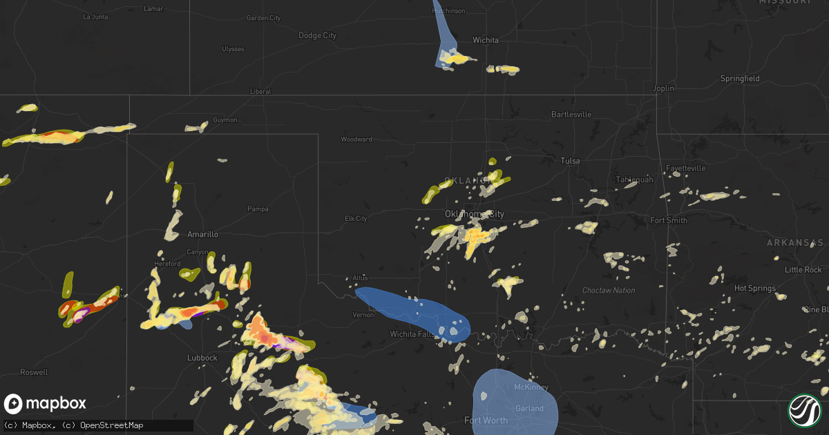
Hail Map in Oklahoma on May 25, 2025
Get this storm
May 25 map
$229
one time, instant access
Download today. No call, no setup
Keep the $229
Bought the map and want the full workflow? Apply the entire $229 to a subscription within 7 days. None of it is wasted.
Every map, not just this one
This buys you this map. Subscription and you get every map we run, in the markets you choose from a few cities to whole states to nationwide. Plus real-time alerts the moment a storm fires.
Contact data
Name, contact info, occupancy, even credit band for addresses in the footprint. You go from where it hit to who to call.
Become the source they trust
Unlimited branding weather history reports on demand. You already have the documented answer ready for the property owner, and you are the one who showed up with it.
Property data and RoofTrace estimates
Pull up any address you have got, its value and the exact code rules for that jurisdiction, straight from One Click Code. Then RoofTrace estimates the squares, pitch, and roof value, priced the way you price.
Storm reports in Oklahoma
Oklahoma
| Date | Description |
|---|---|
| 05/25/20256:41 PM CDT | Report from mping: half dollar |
| 05/25/20256:41 PM CDT | Report from mping: half dollar |
| 05/25/20256:38 PM CDT | A local report indicates 1.50 inch wind near 3 NW Noble |
| 05/25/20256:37 PM CDT | A local report indicates 1.25 inch wind near 3 NNW Noble |
| 05/25/20256:37 PM CDT | Report from mping: ping pong ball |
| 05/25/20256:37 PM CDT | Report from mping: half dollar |
| 05/25/20256:36 PM CDT | Report from mping: half dollar |
| 05/25/20256:31 PM CDT | Report from mping: half dollar |
| 05/25/20256:29 PM CDT | Report from mping: hen egg |
| 05/25/20256:28 PM CDT | Report from mping: half dollar |
| 05/25/20256:25 PM CDT | Report from mping: hen egg |
| 05/25/20256:22 PM CDT | Report from mping: ping pong ball |
| 05/25/20256:21 PM CDT | Report from mping: quarter |
| 05/25/20256:21 PM CDT | Report from mping: ping pong ball |
| 05/25/20256:20 PM CDT | Report from mping: half dollar |
| 05/25/20256:15 PM CDT | A local report indicates 1.00 inch wind near Goldsby |
| 05/25/20256:15 PM CDT | A local report indicates 1.40 inch wind near 5 SE Newcastle |
| 05/25/20256:10 PM CDT | A local report indicates 3.00 inch wind near 2 W Goldsby |
| 05/25/20256:10 PM CDT | A local report indicates 2.75 inch wind near 3 W Norman |
| 05/25/20256:08 PM CDT | Report from mping: quarter |
| 05/25/20255:45 PM CDT | A local report indicates 1.75 inch wind near Dibble |
| 05/25/20255:21 PM CDT | A local report indicates 1.00 inch wind near 5 NE Pocasset |
| 05/25/20253:04 PM CDT | Corrects previous hail report from 3 n roff. |
| 05/25/20253:04 PM CDT | A local report indicates 1.00 inch wind near 3 N Roff |
| 05/25/202512:42 AM CDT | Tree limbs downed. Time estimated by radar. |
| 05/24/20259:20 PM CDT | Corrects previous tstm wnd gst report from 3 w grandfield. |
| 05/24/20258:43 PM CDT | A local report indicates 58 MPH wind near 4 SSE Frederick |
| 05/24/20258:40 PM CDT | Report from mping: quarter |
| 05/24/20257:29 PM CDT | A local report indicates 1.00 inch wind near Coyle |
| 05/24/20257:26 PM CDT | Report from mping: quarter |
| 05/24/20257:15 PM CDT | A local report indicates 1.00 inch wind near 6 N Carney |
All States Impacted by Hail Map on May 25, 2025
Cities Impacted by Hail Map on May 25, 2025
- Anthony, KS
- Burrton, KS
- Buhler, KS
- Haven, KS
- Hutchinson, KS
- Sterling, KS
- South Hutchinson, KS
- Nickerson, KS
- Kingman, KS
- Arlington, KS
- Pretty Prairie, KS
- Partridge, KS
- Cheney, KS
- Murdock, KS
- Spivey, KS
- Harper, KS
- Norwich, KS
- Milton, KS
- Natural Dam, AR
- Stilwell, OK
- Danville, KS
- Conway Springs, KS
- Viola, KS
- Lincoln, AR
- Summers, AR
- Argonia, KS
- Prairie Grove, AR
- Wellington, KS
- Clearwater, KS
- Farmington, AR
- Belle Plaine, KS
- Oxford, KS
- West Fork, AR
- Udall, KS
- Winfield, KS
- Burden, KS
- Ridgeland, SC
- Edisto Island, SC
- Beaufort, SC
- Johns Island, SC
- Cedarville, AR
- Hardeeville, SC
- Coolidge, GA
- Hazlehurst, GA
- Jonesboro, AR
- Haskell, OK
- Ozark, AR
- Denton, GA
- Proctor, OK
- Pettigrew, AR
- Oark, AR
- Tahlequah, OK
- Fort Gibson, OK
- Bluffton, SC
- Park Hill, OK
- Hagarville, AR
- Mulberry, AR
- Mountainburg, AR
- Chester, AR
- Winslow, AR
- Statesboro, GA
- Brooklet, GA
- Pembroke, GA
- Deer, AR
- Leslie, AR
- Ozone, AR
- Davis, OK
- Arlington, TN
- Eads, TN
- Oakland, TN
- Rossville, TN
- Williston, TN
- Moscow, TN
- Collierville, TN
- Cordova, TN
- Memphis, TN
- Wynnewood, OK
- Savannah, GA
- Sulphur, OK
- Canal Point, FL
- Darien, GA
- Townsend, GA
- Hartshorne, OK
- Wilburton, OK
- Mobile, AL
- Matador, TX
- Saint Augustine, FL
- Hartford, AR
- Okolona, AR
- Walden, CO
- Huntington, AR
- Mansfield, AR
- Brunswick, GA
- Flomot, TX
- Red Oak, OK
- Edwards, MS
- Waldron, AR
- Roff, OK
- Floydada, TX
- Deland, FL
- Okeechobee, FL
- Bolton, MS
- Raymond, MS
- Stratford, OK
- Cash, AR
- Simmesport, LA
- De Leon Springs, FL
- Wister, OK
- Elmore City, OK
- Waverly, GA
- Lyon, MS
- Moreauville, LA
- Marks, MS
- Utica, MS
- Jefferson, CO
- Heavener, OK
- Flora, MS
- Woodbine, GA
- Mcadoo, TX
- Bigelow, AR
- Lexington, OK
- Cimarron, NM
- Pauls Valley, OK
- Rison, AR
- Mena, AR
- Kingsland, GA
- Roaring Springs, TX
- Roland, AR
- Perryville, AR
- Thornton, AR
- Saint Marys, GA
- Bentonia, MS
- Vilonia, AR
- Yulee, FL
- Walker, LA
- Livingston, LA
- Denham Springs, LA
- Raton, NM
- Afton, TX
- Dickens, TX
- Pickens, MS
- Immokalee, FL
- Old Glory, TX
- Sims, AR
- Vaughan, MS
- Plainview, AR
- Ada, OK
- Bearden, AR
- Mount Ida, AR
- Paducah, TX
- Benton, MS
- Gurdon, AR
- Aspermont, TX
- Pocasset, OK
- Guntown, MS
- Mantachie, MS
- Saltillo, MS
- Groveland, FL
- Pope, MS
- Courtland, MS
- Rociada, NM
- Sapello, NM
- Talihina, OK
- Greensburg, LA
- Goodman, MS
- Minco, OK
- Buena Vista, NM
- Lindsay, OK
- Smithville, OK
- Oden, AR
- Pencil Bluff, AR
- Blue Springs, MS
- Ecru, MS
- New Albany, MS
- White Hall, AR
- Stevenson, AL
- Labelle, FL
- Clewiston, FL
- Traskwood, AR
- Malvern, AR
- Batesville, MS
- Tupelo, MS
- Springer, NM
- Fulton, MS
- Mulberry, TN
- Lynchburg, TN
- Winchester, TN
- Tullahoma, TN
- Huntland, TN
- Belvidere, TN
- Flintville, TN
- Estill Springs, TN
- Cowan, TN
- Tracy City, TN
- Monteagle, TN
- Pelham, TN
- Decherd, TN
- Sewanee, TN
- Sequatchie, TN
- South Pittsburg, TN
- Sherwood, TN
- Bridgeport, AL
- Hollywood, AL
- Fackler, AL
- Jasper, TN
- Scottsboro, AL
- Estillfork, AL
- Tuttle, OK
- Haines City, FL
- Oklahoma City, OK
- Pine Bluff, AR
- Glenwood, AR
- Amity, AR
- Monticello, AR
- Lockney, TX
- Poyen, AR
- Mora, NM
- Star City, AR
- Sallis, MS
- Water Valley, MS
- Newcastle, OK
- Blanchard, OK
- Amber, OK
- McCall Creek, MS
- Brookhaven, MS
- England, AR
- Quitaque, TX
- Lonoke, AR
- Carlisle, AR
- Story, AR
- Crosbyton, TX
- Purcell, OK
- Vaiden, MS
- Norman, OK
- Taiban, NM
- Happy, TX
- Prattsville, AR
- Sheridan, AR
- Maxwell, NM
- Fort Sumner, NM
- Banks, AR
- Roswell, NM
- Pisgah, AL
- Mentone, AL
- Rising Fawn, GA
- Henagar, AL
- Guild, TN
- Flat Rock, AL
- Summerville, GA
- Higdon, AL
- Valley Head, AL
- La Fayette, GA
- Ider, AL
- Chickamauga, GA
- Bryant, AL
- Trenton, GA
- Menlo, GA
- Chattanooga, TN
- Whitwell, TN
- Lookout Mountain, TN
- Rossville, GA
- Tunnel Hill, GA
- Lookout Mountain, GA
- Rocky Face, GA
- Wildwood, GA
- Fort Oglethorpe, GA
- Trion, GA
- Rock Spring, GA
- Flintstone, GA
- Ringgold, GA
- Elida, NM
- Floyd, NM
- Ocate, NM
- Boynton, OK
- Council Hill, OK
- Camden, AR
- Ashdown, AR
- Holly Grove, AR
- Silverton, TX
- Clarendon, AR
- Choctaw, OK
- West, MS
- Nashoba, OK
- Morris, OK
- Bristow, OK
- French Camp, MS
- De Witt, AR
- Washington, OK
- Prescott, AR
- Felda, FL
- Grapevine, AR
- Elaine, AR
- Eudora, AR
- New Boston, TX
- Spur, TX
- Yukon, OK
- Mustang, OK
- Ethel, AR
- Mooreville, MS
- Senatobia, MS
- Stewart, MS
- Kilmichael, MS
- Okmulgee, OK
- Ethel, MS
- McCaskill, AR
- Nashville, AR
- Lake Village, AR
- Warren, AR
- Hermanville, MS
- Wilmar, AR
- Ackerman, MS
- Eupora, MS
- Anadarko, OK
- Verden, OK
- Fulton, AR
- Delight, AR
- Tulia, TX
- Dimmitt, TX
- Chickasha, OK
- Clarksdale, MS
- Greenville, MS
- Mathiston, MS
- Ozan, AR
- Armuchee, GA
- Calhoun, GA
- Rochester, TX
- O'Brien, TX
- Dundee, MS
- Taft, OK
- Murfreesboro, AR
- Bonnerdale, AR
- Sparkman, AR
- Hamilton, MS
- West Point, MS
- Columbus, MS
- De Kalb, TX
- Coldwater, MS
- Oktaha, OK
- Aberdeen, MS
- Blevins, AR
- Portales, NM
- Maben, MS
- House, NM
- Mcalister, NM
- Mantee, MS
- De Queen, AR
- Edmond, OK
- Chidester, AR
- Oakland, MS
- Lambert, MS
- Plainville, GA
- Adairsville, GA
- Foreman, AR
- Garden City, TX
- Meridian, OK
- Guthrie, OK
- Big Spring, TX
- Arcadia, OK
- Luther, OK
- Caledonia, MS
- Hooks, TX
- Walthall, MS
- Bluff City, AR
- Dierks, AR
- Noble, OK
- Crawford, MS
- Alpine, AL
- Como, MS
- Hope, AR
- Tillatoba, MS
- Wagarville, AL
- Gillham, AR
- Woodland, MS
- Dalton, GA
- Sugar Valley, GA
- Chatsworth, GA
- Resaca, GA
- Rule, TX
- Fairmount, GA
- Ranger, GA
- Talking Rock, GA
- Ellijay, GA
- Jasper, GA
- Dryden, TX
- Hampton, AR
- Nettleton, MS
- Gunnison, MS
- Duncan, MS
- Wellston, OK
- Sardis, MS
- Ethelsville, AL
- Kirby, AR
- Tillar, AR
- Arkansas City, AR
- Rohwer, AR
- Amherst, TX
- Pontotoc, MS
- Houlka, MS
- Winthrop, AR
- Tibbie, AL
- Tutwiler, MS
- McGehee, AR
- Coffeeville, MS
- Vance, MS
- Lockesburg, AR
- Des Moines, NM
- Gladstone, NM
- Clarendon, TX
- Claude, TX
- Sudan, TX
- Philipp, MS
- Shaw, MS
- Boyle, MS
- Beulah, MS
- Benoit, MS
- Houston, MS
- Prairie, MS
- Muskogee, OK
- Rosston, AR
- Emmet, AR
- Bruce, MS
- Kress, TX
- Montrose, AR
- Cartersville, GA
- White, GA
- Hermitage, AR
- Leroy, AL
- Charleston, MS
- Dermott, AR
- Porter, OK
- Schlater, MS
- Cashion, OK
- Merigold, MS
- Cleveland, MS
- Fountain Hill, AR
- Enid, MS
- Drew, MS
- Newalla, OK
- Pheba, MS
- Gail, TX
- Muleshoe, TX
- Okolona, MS
- Acworth, GA
- Grove Hill, AL
- Jackson, AL
- Talladega, AL
- Grenville, NM
- Coyle, OK
- Doddsville, MS
- Minter City, MS
- Haworth, OK
- Earth, TX
- Holcomb, MS
- Steens, MS
- Scobey, MS
- Perkins, OK
- Carney, OK
- Woodstock, GA
- Carrollton, AL
- Canton, GA
- Ruleville, MS
- Kennesaw, GA
- Clovis, NM
- Cannon Afb, NM
- Marietta, GA
- Tryon, OK
- Roswell, GA
- Columbus, AR
- Idabel, OK
- Greenwood, MS
- Anniston, AL
- Grenada, MS
- Shannon, MS
- Haskell, TX
- Atlanta, GA
- Piedmont, OK
- Baldwyn, MS
- Ogden, AR
- Hereford, TX
- Duke, OK
- Altus, OK
- Mulhall, OK
- Stamford, TX
- Crossett, AR
- Brooksville, MS
- Washington, AR
- Saratoga, AR
- Millport, AL
- Iuka, MS
- Burnsville, MS
- Glen, MS
- Tecumseh, OK
- Grannis, AR
- Fieldton, TX
- Littlefield, TX
- Springlake, TX
- Olton, TX
- Knox City, TX
- Canyon, TX
- Friona, TX
- Reform, AL
- Marion, LA
- Stillwater, OK
- Orlando, OK
- Booneville, MS
- Olustee, OK
- Geary, OK
- Calumet, OK
- Horatio, AR
- Duck Hill, MS
- Winona, MS
- Dallas, GA
- Cherokee, AL
- Pelahatchie, MS
- Huttig, AR
- Farmerville, LA
- Rockmart, GA
- Broken Bow, OK
- Mcloud, OK
- Shawnee, OK
- Apache, OK
- Plains, TX
- Post, TX
- Watonga, OK
- Hinton, OK
- Kingfisher, OK
- Clayton, NM
- Hamburg, AR
- Guin, AL
- Sulligent, AL
- Lewisville, AR
- Vega, TX
- Hart, TX
- Okarche, OK
- Oxford, AL
- Morton, MS
- Lovington, NM
- Villa Rica, GA
- Douglasville, GA
- Beaverton, AL
- Chatham, MS
- Perry, OK
- Binger, OK
- Cedarbluff, MS
- Winston, GA
- Justiceburg, TX
- Ralls, TX
- Glen Allan, MS
- Wildorado, TX
- Golden, MS
- Fluvanna, TX
- Glencoe, OK
- Atlanta, TX
- Taylor, AR
- Hale Center, TX
- Plainview, TX
- Starkville, MS
- Bellefontaine, MS
- Calhoun City, MS
- Gore Springs, MS
- Avoca, TX
- Bastrop, LA
- Macon, MS
- Rainsville, NM
- Spencer, OK
- Lookeba, OK
- Earlsboro, OK
- Pulaski, MS
- Cyril, OK
- Hamlin, TX
- Anson, TX
- Queen City, TX
- Forest, MS
- Lena, MS
- Leland, MS
- Channing, TX
- Amory, MS
- Seminole, OK
- Carthage, MS
- Mineral Springs, AR
- Frederick, OK
- Quitman, MS
- Comstock, TX
- Plantersville, MS
- Cement, OK
- Tipton, OK
- Elmer, OK
- Hollister, OK
- Harrold, TX
- Electra, TX
- Davidson, OK
- Odell, TX
- Vernon, TX
- Walters, OK
- Chattanooga, OK
- Loveland, OK
- Grandfield, OK
- Red Bay, AL
- Tremont, MS
- Greenwood Springs, MS
- Detroit, AL
- Hamilton, AL
- Brilliant, AL
- Haleyville, AL
- Bear Creek, AL
- Hackleburg, AL
- Moulton, AL
- Phil Campbell, AL
- Mount Hope, AL
- Russellville, AL
- Vina, AL
- Hodges, AL
- Farwell, TX
- Hermleigh, TX
- Gordo, AL
- Walnut Grove, MS
- Meridian, MS
- Amarillo, TX
- Delta, AL
- Spruce Pine, AL
- Lueders, TX
- Hawley, TX
- Abilene, TX
- Albany, TX
- Dalhart, TX
- Hartley, TX
- Eldorado, OK
- Odonnell, TX
- Faxon, OK
- Coahoma, TX
- Ira, TX
- Canton, MS
- McCaulley, TX
- Lorenzo, TX
- Wewoka, OK
- Okemah, OK
- Raleigh, MS
- Lamesa, TX
- Sweetwater, TX
- Simms, TX
- Sylvester, TX
- Merkel, TX
- Devol, OK
- Randlett, OK
- Burkburnett, TX
- Iowa Park, TX
- Temple, OK
- Roby, TX
- Tahoka, TX
- Newnan, GA
- Sharpsburg, GA
- Louin, MS
- Eufaula, OK
- Dustin, OK
- Weleetka, OK
- Texico, NM
- Tyrone, GA
- Palmetto, GA
- Carrollton, GA
- Bowdon, GA
- Elrod, AL
- Snyder, TX
- Echola, AL
- Eastaboga, AL
- Munford, AL
- Crescent, OK
- Buhl, AL
- Jackson, MS
- Toomsuba, MS
- York, AL
- Livingston, AL
- Trent, TX
- Peachtree City, GA
- Coker, AL
- Jacksonville, FL
- Texhoma, OK
- Roopville, GA
- Marlow, OK
- Rush Springs, OK
- Fletcher, OK
- Hanna, OK
- Rotan, TX
- Clinton, MS
- Throckmorton, TX
- Petrolia, TX
- Hastings, OK
- Waurika, OK
- Wichita Falls, TX
- Byers, TX
- Comanche, OK
- Ryan, OK
- Henrietta, TX
- Terral, OK
- Ringgold, TX
- Ringling, OK
- Stonewall, MS
- Wedowee, AL
- Lineville, AL
- Del Rio, TX
- Jayton, TX
- Goodwell, OK
- Cuba, AL
- Boligee, AL
- Fosters, AL
- Ralph, AL
- Duncan, OK
- Butler, AL
- Tuscaloosa, AL
- Coleman, OK
- Milburn, OK
- Bradley, OK
- Dyess Afb, TX
- Garvin, OK
- Atoka, OK
- Lubbock, TX
- Knoxville, AL
- Checotah, OK
- Eutaw, AL
- Saint Jo, TX
- Nocona, TX
- Gruver, TX
- Clarksville, TX
- Gainesville, AL
- Tye, TX
- Franklin, GA
- Enterprise, MS
- Alex, OK
- Maysville, OK
- Tishomingo, OK
- Moundville, AL
- Girard, TX
- Tuscola, TX
- Epes, AL
- Clyde, TX
- Woodland, AL
- Woodson, TX
- Buffalo Gap, TX
- Rocksprings, TX
- Burneyville, OK
- Nara Visa, NM
- Madill, OK
- Lisman, AL
- Marion, MS
- Overbrook, OK
- Garland City, AR
- Bellevue, TX
- Roanoke, AL
- Marietta, OK
- Moran, TX
- Honey Grove, TX
- Brackettville, TX
- Amistad, NM
- Bowie, TX
- Montague, TX
- Duncanville, AL
- Lane, OK
- Brooks, GA
- Antlers, OK
- Baird, TX
- Breckenridge, TX
- Muenster, TX
- Sunset, TX
- Sterlington, LA
- Vincent, AL
- Talco, TX
- Forestburg, TX
- Chico, TX
- Boswell, OK
- Bennington, OK
- Gainesville, TX
- Concan, TX
- Sabinal, TX
- Alvord, TX
- Telephone, TX
- Camp Wood, TX
- Valley View, TX
- Sadler, TX
- Gordonville, TX
- Kingston, OK
- Spearman, TX
- Boise City, OK
- Griffin, GA
- Petersburg, TX
- Rockford, AL
- Sherman, TX
- Denison, TX
- Mannsville, OK
- Ovalo, TX
- Hugo, OK
- Sumner, TX
- Powderly, TX
- Arthur City, TX
- Grant, OK
- Justin, TX
- Haslet, TX
- Rhome, TX
- Detroit, TX
- Paris, TX
- Blossom, TX
- Weatherford, TX
- Natchitoches, LA
- Poolville, TX
- Krum, TX
- Sanger, TX
- Pilot Point, TX
- Celina, TX
- Prosper, TX
- Melissa, TX
- Aubrey, TX
- Mckinney, TX
- Haltom City, TX
- Ponder, TX
- Keller, TX
- Frisco, TX
- Roanoke, TX
- North Richland Hills, TX
- Bedford, TX
- Southlake, TX
- Lake Dallas, TX
- Irving, TX
- Grapevine, TX
- Plano, TX
- Denton, TX
- Fort Worth, TX
- Coppell, TX
- Dallas, TX
- Flower Mound, TX
- Colleyville, TX
- Argyle, TX
- Hurst, TX
- Lewisville, TX
- The Colony, TX
- Carrollton, TX
- Little Elm, TX
- Euless, TX
- Allen, TX
- Anna, TX
- Wylie, TX
- Addison, TX
- Nevada, TX
- Princeton, TX
- Richardson, TX
- Farmersville, TX
- Arlington, TX
- Grand Prairie, TX
- Kennedale, TX
- Mansfield, TX
- Garland, TX
- Sachse, TX
- Burleson, TX
- Crowley, TX
- Aledo, TX
- Joshua, TX
- Decatur, TX
- Naval Air Station Jrb, TX
- Newark, TX
- Azle, TX
- Boyd, TX
- Lavon, TX
- Caddo Mills, TX
- Rowlett, TX
- Rockwall, TX
- Royse City, TX
- Sunnyvale, TX
- Mesquite, TX
- Red Oak, TX
- Lillian, TX
- Cedar Hill, TX
- Alvarado, TX
- Seagoville, TX
- Crandall, TX
- Venus, TX
- Midlothian, TX
- Lancaster, TX
- Forney, TX
- Desoto, TX
- Duncanville, TX
- Ferris, TX
- Wilmer, TX
- Hutchins, TX
- Terrell, TX
- Balch Springs, TX
- Brookston, TX
- Graford, TX
- Palo Pinto, TX
- Quinlan, TX
- Kemp, TX
- Kaufman, TX
- Scurry, TX
- Waxahachie, TX
- Palmer, TX
- Rosser, TX
- Ennis, TX
- Chatfield, TX
- Forreston, TX
- Rice, TX
- Corsicana, TX
- Italy, TX
- Milford, TX
- Itasca, TX
- Grandview, TX
- Maypearl, TX
- Cleburne, TX
- Keene, TX
- Godley, TX
- Santo, TX
- Gordon, TX
- Lipan, TX
- Stephenville, TX
- Millsap, TX
- Senoia, GA
- Nazareth, TX
- Slaton, TX
- Granbury, TX
- Bluff Dale, TX
- Jachin, AL
- Eustace, TX
- Caddo, TX
- Bullard, TX
- Flint, TX
- Tyler, TX
- Whitehouse, TX
- Troup, TX
- Ranger, TX
- Hillsboro, TX
- Abbott, TX
- Bynum, TX
- Covington, TX
- Blum, TX
- Rio Vista, TX
- Malone, TX
- Mertens, TX
- Blooming Grove, TX
- Barry, TX
- Frost, TX
- Longview, TX
- Hallsville, TX
- Jacksonville, TX
- Henderson, TX


