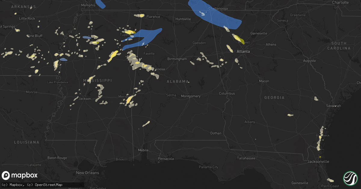
Hail Map in Alabama on May 25, 2025
Get this storm
May 25 map
$229
one time, instant access
Download today. No call, no setup
Keep the $229
Bought the map and want the full workflow? Apply the entire $229 to a subscription within 7 days. None of it is wasted.
Every map, not just this one
This buys you this map. Subscription and you get every map we run, in the markets you choose from a few cities to whole states to nationwide. Plus real-time alerts the moment a storm fires.
Contact data
Name, contact info, occupancy, even credit band for addresses in the footprint. You go from where it hit to who to call.
Become the source they trust
Unlimited branding weather history reports on demand. You already have the documented answer ready for the property owner, and you are the one who showed up with it.
Property data and RoofTrace estimates
Pull up any address you have got, its value and the exact code rules for that jurisdiction, straight from One Click Code. Then RoofTrace estimates the squares, pitch, and roof value, priced the way you price.
Storm reports in Alabama
Alabama
| Date | Description |
|---|---|
| 05/25/20256:45 PM CDT | 14 power poles down on cr 34. Time estimated from radar. |
| 05/25/20254:54 PM CDT | Ema reported a tree down across the road at 7000 hwy 35 in scottsboro al. |
| 05/25/20254:45 PM CDT | Ema reported a tree down across the road at 45549 al hwy 277 in bridgeport al. |
| 05/25/20254:26 PM CDT | Ema reported a tree down at the intersection of hwy 79 and hwy 35 in jackson county. |
| 05/25/20253:33 PM CDT | Ema reported a tree down blocking both lanes at 33041 al hwy 99. |
| 05/25/20253:12 PM CDT | Lauderdale al 911 call center reported a power pole leaning at 1457 wallace mill rd. |
| 05/24/202511:05 PM CDT | A tree was downed at highway 25 and cr 16. |
| 05/24/202510:15 PM CDT | Multiple trees were downed across sumter county. |
| 05/24/202510:07 PM CDT | Cullman county ema reported a tree down at cr 109 and cr 222. |
| 05/24/20259:58 PM CDT | Trees down along highway 171 and along tierce patton rd. |
| 05/24/20259:55 PM CDT | Two trees were downed in cuba. |
| 05/24/20259:45 PM CDT | Quarter-size hail was reported along county road |
| 05/24/20259:45 PM CDT | Quarter-size hail was reported along county road 1 south of cuba. |
| 05/24/20259:34 PM CDT | Report from mping: quarter |
| 05/24/20259:28 PM CDT | Morgan county ema reported a tree down along barely bridge rd and perry anders rd. |
| 05/24/20259:25 PM CDT | A tree was downed along us highway 278 near addison. |
| 05/24/20259:13 PM CDT | Lawrence county ema reports a tree down along cr 39 in the mount hope area. |
| 05/24/20259:10 PM CDT | Tree down - time estimated from radar. |
| 05/24/20259:10 PM CDT | Tree down - time estimated from radar. |
| 05/24/20259:04 PM CDT | Trees downed in the gordo area. |
| 05/24/20258:51 PM CDT | Several trees down around haleyville... With a couple on power lines. |
| 05/24/20258:47 PM CDT | Several trees down in the western part of haleyville in marion county. |
| 05/24/20258:45 PM CDT | Trees were downed in the reform area. |
| 05/24/20258:42 PM CDT | Numerous trees were downed in the bear creek and hackleburg areas... Resulting in power outages. |
| 05/24/20258:19 PM CDT | Trees were downed in the ethelsville area. |
| 05/24/20258:04 PM CDT | Trees were downed along county road 157 and highway 19. |
| 05/24/20257:30 PM CDT | Quarter-size hail was reported in the ethelsville area. |
| 05/24/20257:20 PM CDT | Trees blocking both lanes of northbound hwy 43. Time estimated from radar. |
| 05/24/20257:01 PM CDT | Trees down on west point dr. Time estimated from radar. |
| 05/24/20257:01 PM CDT | Trees and power lines down near intersection of high acres dr. And shamrock dr. Time estimated from radar. |
| 05/24/20257:01 PM CDT | Trees down on bolen dr. Time estimated from radar. |
| 05/24/20257:00 PM CDT | Trees and power lines down on catherine st. Time estimated from radar. |
All States Impacted by Hail Map on May 25, 2025
Cities Impacted by Hail Map on May 25, 2025
- Anthony, KS
- Burrton, KS
- Buhler, KS
- Haven, KS
- Hutchinson, KS
- Sterling, KS
- South Hutchinson, KS
- Nickerson, KS
- Kingman, KS
- Arlington, KS
- Pretty Prairie, KS
- Partridge, KS
- Cheney, KS
- Murdock, KS
- Spivey, KS
- Harper, KS
- Norwich, KS
- Milton, KS
- Natural Dam, AR
- Stilwell, OK
- Danville, KS
- Conway Springs, KS
- Viola, KS
- Lincoln, AR
- Summers, AR
- Argonia, KS
- Prairie Grove, AR
- Wellington, KS
- Clearwater, KS
- Farmington, AR
- Belle Plaine, KS
- Oxford, KS
- West Fork, AR
- Udall, KS
- Winfield, KS
- Burden, KS
- Ridgeland, SC
- Edisto Island, SC
- Beaufort, SC
- Johns Island, SC
- Cedarville, AR
- Hardeeville, SC
- Coolidge, GA
- Hazlehurst, GA
- Jonesboro, AR
- Haskell, OK
- Ozark, AR
- Denton, GA
- Proctor, OK
- Pettigrew, AR
- Oark, AR
- Tahlequah, OK
- Fort Gibson, OK
- Bluffton, SC
- Park Hill, OK
- Hagarville, AR
- Mulberry, AR
- Mountainburg, AR
- Chester, AR
- Winslow, AR
- Statesboro, GA
- Brooklet, GA
- Pembroke, GA
- Deer, AR
- Leslie, AR
- Ozone, AR
- Davis, OK
- Arlington, TN
- Eads, TN
- Oakland, TN
- Rossville, TN
- Williston, TN
- Moscow, TN
- Collierville, TN
- Cordova, TN
- Memphis, TN
- Wynnewood, OK
- Savannah, GA
- Sulphur, OK
- Canal Point, FL
- Darien, GA
- Townsend, GA
- Hartshorne, OK
- Wilburton, OK
- Mobile, AL
- Matador, TX
- Saint Augustine, FL
- Hartford, AR
- Okolona, AR
- Walden, CO
- Huntington, AR
- Mansfield, AR
- Brunswick, GA
- Flomot, TX
- Red Oak, OK
- Edwards, MS
- Waldron, AR
- Roff, OK
- Floydada, TX
- Deland, FL
- Okeechobee, FL
- Bolton, MS
- Raymond, MS
- Stratford, OK
- Cash, AR
- Simmesport, LA
- De Leon Springs, FL
- Wister, OK
- Elmore City, OK
- Waverly, GA
- Lyon, MS
- Moreauville, LA
- Marks, MS
- Utica, MS
- Jefferson, CO
- Heavener, OK
- Flora, MS
- Woodbine, GA
- Mcadoo, TX
- Bigelow, AR
- Lexington, OK
- Cimarron, NM
- Pauls Valley, OK
- Rison, AR
- Mena, AR
- Kingsland, GA
- Roaring Springs, TX
- Roland, AR
- Perryville, AR
- Thornton, AR
- Saint Marys, GA
- Bentonia, MS
- Vilonia, AR
- Yulee, FL
- Walker, LA
- Livingston, LA
- Denham Springs, LA
- Raton, NM
- Afton, TX
- Dickens, TX
- Pickens, MS
- Immokalee, FL
- Old Glory, TX
- Sims, AR
- Vaughan, MS
- Plainview, AR
- Ada, OK
- Bearden, AR
- Mount Ida, AR
- Paducah, TX
- Benton, MS
- Gurdon, AR
- Aspermont, TX
- Pocasset, OK
- Guntown, MS
- Mantachie, MS
- Saltillo, MS
- Groveland, FL
- Pope, MS
- Courtland, MS
- Rociada, NM
- Sapello, NM
- Talihina, OK
- Greensburg, LA
- Goodman, MS
- Minco, OK
- Buena Vista, NM
- Lindsay, OK
- Smithville, OK
- Oden, AR
- Pencil Bluff, AR
- Blue Springs, MS
- Ecru, MS
- New Albany, MS
- White Hall, AR
- Stevenson, AL
- Labelle, FL
- Clewiston, FL
- Traskwood, AR
- Malvern, AR
- Batesville, MS
- Tupelo, MS
- Springer, NM
- Fulton, MS
- Mulberry, TN
- Lynchburg, TN
- Winchester, TN
- Tullahoma, TN
- Huntland, TN
- Belvidere, TN
- Flintville, TN
- Estill Springs, TN
- Cowan, TN
- Tracy City, TN
- Monteagle, TN
- Pelham, TN
- Decherd, TN
- Sewanee, TN
- Sequatchie, TN
- South Pittsburg, TN
- Sherwood, TN
- Bridgeport, AL
- Hollywood, AL
- Fackler, AL
- Jasper, TN
- Scottsboro, AL
- Estillfork, AL
- Tuttle, OK
- Haines City, FL
- Oklahoma City, OK
- Pine Bluff, AR
- Glenwood, AR
- Amity, AR
- Monticello, AR
- Lockney, TX
- Poyen, AR
- Mora, NM
- Star City, AR
- Sallis, MS
- Water Valley, MS
- Newcastle, OK
- Blanchard, OK
- Amber, OK
- McCall Creek, MS
- Brookhaven, MS
- England, AR
- Quitaque, TX
- Lonoke, AR
- Carlisle, AR
- Story, AR
- Crosbyton, TX
- Purcell, OK
- Vaiden, MS
- Norman, OK
- Taiban, NM
- Happy, TX
- Prattsville, AR
- Sheridan, AR
- Maxwell, NM
- Fort Sumner, NM
- Banks, AR
- Roswell, NM
- Pisgah, AL
- Mentone, AL
- Rising Fawn, GA
- Henagar, AL
- Guild, TN
- Flat Rock, AL
- Summerville, GA
- Higdon, AL
- Valley Head, AL
- La Fayette, GA
- Ider, AL
- Chickamauga, GA
- Bryant, AL
- Trenton, GA
- Menlo, GA
- Chattanooga, TN
- Whitwell, TN
- Lookout Mountain, TN
- Rossville, GA
- Tunnel Hill, GA
- Lookout Mountain, GA
- Rocky Face, GA
- Wildwood, GA
- Fort Oglethorpe, GA
- Trion, GA
- Rock Spring, GA
- Flintstone, GA
- Ringgold, GA
- Elida, NM
- Floyd, NM
- Ocate, NM
- Boynton, OK
- Council Hill, OK
- Camden, AR
- Ashdown, AR
- Holly Grove, AR
- Silverton, TX
- Clarendon, AR
- Choctaw, OK
- West, MS
- Nashoba, OK
- Morris, OK
- Bristow, OK
- French Camp, MS
- De Witt, AR
- Washington, OK
- Prescott, AR
- Felda, FL
- Grapevine, AR
- Elaine, AR
- Eudora, AR
- New Boston, TX
- Spur, TX
- Yukon, OK
- Mustang, OK
- Ethel, AR
- Mooreville, MS
- Senatobia, MS
- Stewart, MS
- Kilmichael, MS
- Okmulgee, OK
- Ethel, MS
- McCaskill, AR
- Nashville, AR
- Lake Village, AR
- Warren, AR
- Hermanville, MS
- Wilmar, AR
- Ackerman, MS
- Eupora, MS
- Anadarko, OK
- Verden, OK
- Fulton, AR
- Delight, AR
- Tulia, TX
- Dimmitt, TX
- Chickasha, OK
- Clarksdale, MS
- Greenville, MS
- Mathiston, MS
- Ozan, AR
- Armuchee, GA
- Calhoun, GA
- Rochester, TX
- O'Brien, TX
- Dundee, MS
- Taft, OK
- Murfreesboro, AR
- Bonnerdale, AR
- Sparkman, AR
- Hamilton, MS
- West Point, MS
- Columbus, MS
- De Kalb, TX
- Coldwater, MS
- Oktaha, OK
- Aberdeen, MS
- Blevins, AR
- Portales, NM
- Maben, MS
- House, NM
- Mcalister, NM
- Mantee, MS
- De Queen, AR
- Edmond, OK
- Chidester, AR
- Oakland, MS
- Lambert, MS
- Plainville, GA
- Adairsville, GA
- Foreman, AR
- Garden City, TX
- Meridian, OK
- Guthrie, OK
- Big Spring, TX
- Arcadia, OK
- Luther, OK
- Caledonia, MS
- Hooks, TX
- Walthall, MS
- Bluff City, AR
- Dierks, AR
- Noble, OK
- Crawford, MS
- Alpine, AL
- Como, MS
- Hope, AR
- Tillatoba, MS
- Wagarville, AL
- Gillham, AR
- Woodland, MS
- Dalton, GA
- Sugar Valley, GA
- Chatsworth, GA
- Resaca, GA
- Rule, TX
- Fairmount, GA
- Ranger, GA
- Talking Rock, GA
- Ellijay, GA
- Jasper, GA
- Dryden, TX
- Hampton, AR
- Nettleton, MS
- Gunnison, MS
- Duncan, MS
- Wellston, OK
- Sardis, MS
- Ethelsville, AL
- Kirby, AR
- Tillar, AR
- Arkansas City, AR
- Rohwer, AR
- Amherst, TX
- Pontotoc, MS
- Houlka, MS
- Winthrop, AR
- Tibbie, AL
- Tutwiler, MS
- McGehee, AR
- Coffeeville, MS
- Vance, MS
- Lockesburg, AR
- Des Moines, NM
- Gladstone, NM
- Clarendon, TX
- Claude, TX
- Sudan, TX
- Philipp, MS
- Shaw, MS
- Boyle, MS
- Beulah, MS
- Benoit, MS
- Houston, MS
- Prairie, MS
- Muskogee, OK
- Rosston, AR
- Emmet, AR
- Bruce, MS
- Kress, TX
- Montrose, AR
- Cartersville, GA
- White, GA
- Hermitage, AR
- Leroy, AL
- Charleston, MS
- Dermott, AR
- Porter, OK
- Schlater, MS
- Cashion, OK
- Merigold, MS
- Cleveland, MS
- Fountain Hill, AR
- Enid, MS
- Drew, MS
- Newalla, OK
- Pheba, MS
- Gail, TX
- Muleshoe, TX
- Okolona, MS
- Acworth, GA
- Grove Hill, AL
- Jackson, AL
- Talladega, AL
- Grenville, NM
- Coyle, OK
- Doddsville, MS
- Minter City, MS
- Haworth, OK
- Earth, TX
- Holcomb, MS
- Steens, MS
- Scobey, MS
- Perkins, OK
- Carney, OK
- Woodstock, GA
- Carrollton, AL
- Canton, GA
- Ruleville, MS
- Kennesaw, GA
- Clovis, NM
- Cannon Afb, NM
- Marietta, GA
- Tryon, OK
- Roswell, GA
- Columbus, AR
- Idabel, OK
- Greenwood, MS
- Anniston, AL
- Grenada, MS
- Shannon, MS
- Haskell, TX
- Atlanta, GA
- Piedmont, OK
- Baldwyn, MS
- Ogden, AR
- Hereford, TX
- Duke, OK
- Altus, OK
- Mulhall, OK
- Stamford, TX
- Crossett, AR
- Brooksville, MS
- Washington, AR
- Saratoga, AR
- Millport, AL
- Iuka, MS
- Burnsville, MS
- Glen, MS
- Tecumseh, OK
- Grannis, AR
- Fieldton, TX
- Littlefield, TX
- Springlake, TX
- Olton, TX
- Knox City, TX
- Canyon, TX
- Friona, TX
- Reform, AL
- Marion, LA
- Stillwater, OK
- Orlando, OK
- Booneville, MS
- Olustee, OK
- Geary, OK
- Calumet, OK
- Horatio, AR
- Duck Hill, MS
- Winona, MS
- Dallas, GA
- Cherokee, AL
- Pelahatchie, MS
- Huttig, AR
- Farmerville, LA
- Rockmart, GA
- Broken Bow, OK
- Mcloud, OK
- Shawnee, OK
- Apache, OK
- Plains, TX
- Post, TX
- Watonga, OK
- Hinton, OK
- Kingfisher, OK
- Clayton, NM
- Hamburg, AR
- Guin, AL
- Sulligent, AL
- Lewisville, AR
- Vega, TX
- Hart, TX
- Okarche, OK
- Oxford, AL
- Morton, MS
- Lovington, NM
- Villa Rica, GA
- Douglasville, GA
- Beaverton, AL
- Chatham, MS
- Perry, OK
- Binger, OK
- Cedarbluff, MS
- Winston, GA
- Justiceburg, TX
- Ralls, TX
- Glen Allan, MS
- Wildorado, TX
- Golden, MS
- Fluvanna, TX
- Glencoe, OK
- Atlanta, TX
- Taylor, AR
- Hale Center, TX
- Plainview, TX
- Starkville, MS
- Bellefontaine, MS
- Calhoun City, MS
- Gore Springs, MS
- Avoca, TX
- Bastrop, LA
- Macon, MS
- Rainsville, NM
- Spencer, OK
- Lookeba, OK
- Earlsboro, OK
- Pulaski, MS
- Cyril, OK
- Hamlin, TX
- Anson, TX
- Queen City, TX
- Forest, MS
- Lena, MS
- Leland, MS
- Channing, TX
- Amory, MS
- Seminole, OK
- Carthage, MS
- Mineral Springs, AR
- Frederick, OK
- Quitman, MS
- Comstock, TX
- Plantersville, MS
- Cement, OK
- Tipton, OK
- Elmer, OK
- Hollister, OK
- Harrold, TX
- Electra, TX
- Davidson, OK
- Odell, TX
- Vernon, TX
- Walters, OK
- Chattanooga, OK
- Loveland, OK
- Grandfield, OK
- Red Bay, AL
- Tremont, MS
- Greenwood Springs, MS
- Detroit, AL
- Hamilton, AL
- Brilliant, AL
- Haleyville, AL
- Bear Creek, AL
- Hackleburg, AL
- Moulton, AL
- Phil Campbell, AL
- Mount Hope, AL
- Russellville, AL
- Vina, AL
- Hodges, AL
- Farwell, TX
- Hermleigh, TX
- Gordo, AL
- Walnut Grove, MS
- Meridian, MS
- Amarillo, TX
- Delta, AL
- Spruce Pine, AL
- Lueders, TX
- Hawley, TX
- Abilene, TX
- Albany, TX
- Dalhart, TX
- Hartley, TX
- Eldorado, OK
- Odonnell, TX
- Faxon, OK
- Coahoma, TX
- Ira, TX
- Canton, MS
- McCaulley, TX
- Lorenzo, TX
- Wewoka, OK
- Okemah, OK
- Raleigh, MS
- Lamesa, TX
- Sweetwater, TX
- Simms, TX
- Sylvester, TX
- Merkel, TX
- Devol, OK
- Randlett, OK
- Burkburnett, TX
- Iowa Park, TX
- Temple, OK
- Roby, TX
- Tahoka, TX
- Newnan, GA
- Sharpsburg, GA
- Louin, MS
- Eufaula, OK
- Dustin, OK
- Weleetka, OK
- Texico, NM
- Tyrone, GA
- Palmetto, GA
- Carrollton, GA
- Bowdon, GA
- Elrod, AL
- Snyder, TX
- Echola, AL
- Eastaboga, AL
- Munford, AL
- Crescent, OK
- Buhl, AL
- Jackson, MS
- Toomsuba, MS
- York, AL
- Livingston, AL
- Trent, TX
- Peachtree City, GA
- Coker, AL
- Jacksonville, FL
- Texhoma, OK
- Roopville, GA
- Marlow, OK
- Rush Springs, OK
- Fletcher, OK
- Hanna, OK
- Rotan, TX
- Clinton, MS
- Throckmorton, TX
- Petrolia, TX
- Hastings, OK
- Waurika, OK
- Wichita Falls, TX
- Byers, TX
- Comanche, OK
- Ryan, OK
- Henrietta, TX
- Terral, OK
- Ringgold, TX
- Ringling, OK
- Stonewall, MS
- Wedowee, AL
- Lineville, AL
- Del Rio, TX
- Jayton, TX
- Goodwell, OK
- Cuba, AL
- Boligee, AL
- Fosters, AL
- Ralph, AL
- Duncan, OK
- Butler, AL
- Tuscaloosa, AL
- Coleman, OK
- Milburn, OK
- Bradley, OK
- Dyess Afb, TX
- Garvin, OK
- Atoka, OK
- Lubbock, TX
- Knoxville, AL
- Checotah, OK
- Eutaw, AL
- Saint Jo, TX
- Nocona, TX
- Gruver, TX
- Clarksville, TX
- Gainesville, AL
- Tye, TX
- Franklin, GA
- Enterprise, MS
- Alex, OK
- Maysville, OK
- Tishomingo, OK
- Moundville, AL
- Girard, TX
- Tuscola, TX
- Epes, AL
- Clyde, TX
- Woodland, AL
- Woodson, TX
- Buffalo Gap, TX
- Rocksprings, TX
- Burneyville, OK
- Nara Visa, NM
- Madill, OK
- Lisman, AL
- Marion, MS
- Overbrook, OK
- Garland City, AR
- Bellevue, TX
- Roanoke, AL
- Marietta, OK
- Moran, TX
- Honey Grove, TX
- Brackettville, TX
- Amistad, NM
- Bowie, TX
- Montague, TX
- Duncanville, AL
- Lane, OK
- Brooks, GA
- Antlers, OK
- Baird, TX
- Breckenridge, TX
- Muenster, TX
- Sunset, TX
- Sterlington, LA
- Vincent, AL
- Talco, TX
- Forestburg, TX
- Chico, TX
- Boswell, OK
- Bennington, OK
- Gainesville, TX
- Concan, TX
- Sabinal, TX
- Alvord, TX
- Telephone, TX
- Camp Wood, TX
- Valley View, TX
- Sadler, TX
- Gordonville, TX
- Kingston, OK
- Spearman, TX
- Boise City, OK
- Griffin, GA
- Petersburg, TX
- Rockford, AL
- Sherman, TX
- Denison, TX
- Mannsville, OK
- Ovalo, TX
- Hugo, OK
- Sumner, TX
- Powderly, TX
- Arthur City, TX
- Grant, OK
- Justin, TX
- Haslet, TX
- Rhome, TX
- Detroit, TX
- Paris, TX
- Blossom, TX
- Weatherford, TX
- Natchitoches, LA
- Poolville, TX
- Krum, TX
- Sanger, TX
- Pilot Point, TX
- Celina, TX
- Prosper, TX
- Melissa, TX
- Aubrey, TX
- Mckinney, TX
- Haltom City, TX
- Ponder, TX
- Keller, TX
- Frisco, TX
- Roanoke, TX
- North Richland Hills, TX
- Bedford, TX
- Southlake, TX
- Lake Dallas, TX
- Irving, TX
- Grapevine, TX
- Plano, TX
- Denton, TX
- Fort Worth, TX
- Coppell, TX
- Dallas, TX
- Flower Mound, TX
- Colleyville, TX
- Argyle, TX
- Hurst, TX
- Lewisville, TX
- The Colony, TX
- Carrollton, TX
- Little Elm, TX
- Euless, TX
- Allen, TX
- Anna, TX
- Wylie, TX
- Addison, TX
- Nevada, TX
- Princeton, TX
- Richardson, TX
- Farmersville, TX
- Arlington, TX
- Grand Prairie, TX
- Kennedale, TX
- Mansfield, TX
- Garland, TX
- Sachse, TX
- Burleson, TX
- Crowley, TX
- Aledo, TX
- Joshua, TX
- Decatur, TX
- Naval Air Station Jrb, TX
- Newark, TX
- Azle, TX
- Boyd, TX
- Lavon, TX
- Caddo Mills, TX
- Rowlett, TX
- Rockwall, TX
- Royse City, TX
- Sunnyvale, TX
- Mesquite, TX
- Red Oak, TX
- Lillian, TX
- Cedar Hill, TX
- Alvarado, TX
- Seagoville, TX
- Crandall, TX
- Venus, TX
- Midlothian, TX
- Lancaster, TX
- Forney, TX
- Desoto, TX
- Duncanville, TX
- Ferris, TX
- Wilmer, TX
- Hutchins, TX
- Terrell, TX
- Balch Springs, TX
- Brookston, TX
- Graford, TX
- Palo Pinto, TX
- Quinlan, TX
- Kemp, TX
- Kaufman, TX
- Scurry, TX
- Waxahachie, TX
- Palmer, TX
- Rosser, TX
- Ennis, TX
- Chatfield, TX
- Forreston, TX
- Rice, TX
- Corsicana, TX
- Italy, TX
- Milford, TX
- Itasca, TX
- Grandview, TX
- Maypearl, TX
- Cleburne, TX
- Keene, TX
- Godley, TX
- Santo, TX
- Gordon, TX
- Lipan, TX
- Stephenville, TX
- Millsap, TX
- Senoia, GA
- Nazareth, TX
- Slaton, TX
- Granbury, TX
- Bluff Dale, TX
- Jachin, AL
- Eustace, TX
- Caddo, TX
- Bullard, TX
- Flint, TX
- Tyler, TX
- Whitehouse, TX
- Troup, TX
- Ranger, TX
- Hillsboro, TX
- Abbott, TX
- Bynum, TX
- Covington, TX
- Blum, TX
- Rio Vista, TX
- Malone, TX
- Mertens, TX
- Blooming Grove, TX
- Barry, TX
- Frost, TX
- Longview, TX
- Hallsville, TX
- Jacksonville, TX
- Henderson, TX


