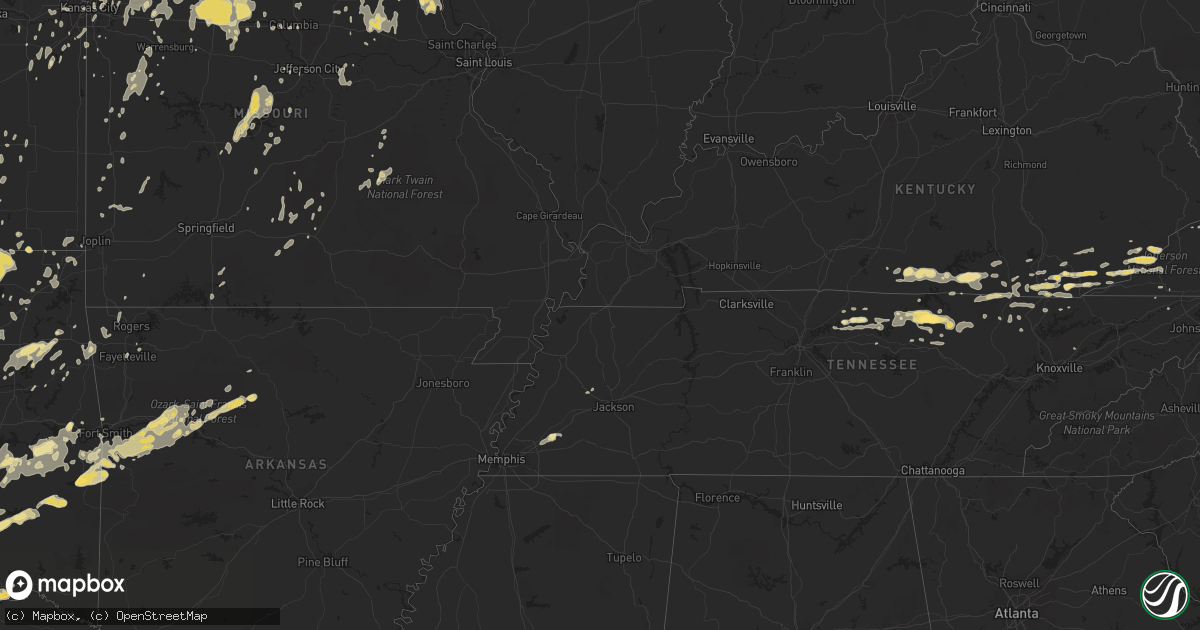
Hail Map in Kansas on May 24, 2011
Get this storm
May 24 map
$229
one time, instant access
Download today. No call, no setup
Keep the $229
Bought the map and want the full workflow? Apply the entire $229 to a subscription within 7 days. None of it is wasted.
Every map, not just this one
This buys you this map. Subscription and you get every map we run, in the markets you choose from a few cities to whole states to nationwide. Plus real-time alerts the moment a storm fires.
Contact data
Name, contact info, occupancy, even credit band for addresses in the footprint. You go from where it hit to who to call.
Become the source they trust
Unlimited branding weather history reports on demand. You already have the documented answer ready for the property owner, and you are the one who showed up with it.
Property data and RoofTrace estimates
Pull up any address you have got, its value and the exact code rules for that jurisdiction, straight from One Click Code. Then RoofTrace estimates the squares, pitch, and roof value, priced the way you price.
Storm reports in Kansas
Kansas
| Date | Description |
|---|---|
| 05/24/20116:55 PM CDT | A local report indicates 62 MPH wind near GREAT BEND AIRPORT |
| 05/24/20116:45 PM CDT | Law enforcement estimates 70 mph winds. |
| 05/24/20116:36 PM CDT | A local report indicates 1.75 inch wind near 9 SSE LA CROSSE |
| 05/24/20116:30 PM CDT | A local report indicates 1.75 inch wind near 9 SSE LA CROSSE |
| 05/24/20116:28 PM CDT | A local report indicates 1.00 inch wind near 8 S GORHAM |
| 05/24/20116:26 PM CDT | Florence fire department reports winds of 60 mph and heavy rain. |
| 05/24/20116:24 PM CDT | Emergency manager reports that a semi trailer was blown over between mile markers 82 and 83 on the kansas turnpike. |
| 05/24/20116:21 PM CDT | A local report indicates 1.00 inch wind near 4 WNW GALATIA |
| 05/24/20116:20 PM CDT | Trained spotter reports quarter and nickel sized hail. |
| 05/24/20116:17 PM CDT | Trained spotter reports 8 to 10 inch diameter tree limbs down on 3rd street. |
| 05/24/20116:16 PM CDT | Fire fighter reports winds of 65 mph if not greater. |
| 05/24/20116:15 PM CDT | A roof was blown from a building and power poles were blown down in lacrosse. |
| 05/24/20116:15 PM CDT | Law enforcement reports 60 mph winds at timber south of 40th. |
| 05/24/20116:00 PM CDT | A local report indicates 2.75 inch wind near ALEXANDER |
| 05/24/20115:53 PM CDT | Trained spotter estimates wind gusts to 60 to 65 mph. |
| 05/24/20115:49 PM CDT | A local report indicates 1.50 inch wind near 4 NNW LORETTA |
| 05/24/20115:48 PM CDT | A local report indicates 1.75 inch wind near ENE ALEXANDER |
| 05/24/20115:44 PM CDT | Emergency manager reports power lines down at 143rd street and us 54. |
| 05/24/20115:44 PM CDT | Emergency manager reports power lines down at k96 and us 54 which blocked traffic on the ramp from south bound k96 to east bound 54. |
| 05/24/20115:44 PM CDT | Emergency manager reports the city of nickerson is without power. |
| 05/24/20115:37 PM CDT | This tornado a reported a possible very large and rain wrapped. Location estimated. |
| 05/24/20115:36 PM CDT | Report was from storm chasers relayed from nws wichita. |
| 05/24/20115:35 PM CDT | Amateur radio reports 70 mph winds for approximately 5 minutes. |
| 05/24/20115:34 PM CDT | A local report indicates 59 MPH wind near HUTCHINSON AIRPORT |
| 05/24/20115:30 PM CDT | Moderate to severe tornado damage north of st. John on us 281. |
| 05/24/20115:30 PM CDT | Hail was covering the ground. |
| 05/24/20115:27 PM CDT | A local report indicates a tornado near 10 S OTIS |
| 05/24/20115:25 PM CDT | Houses damaged |
| 05/24/20115:24 PM CDT | Kwch storm chaser reports 50 to 60 mph winds near caldwell. |
| 05/24/20115:22 PM CDT | Amateur radio reports 18 to 20 inch diameter trees down north of k19 and 281. |
| 05/24/20115:21 PM CDT | Giant hail measured at 6 inches in diameter fell through the roof of a church in timken. |
| 05/24/20115:20 PM CDT | A local report indicates a tornado near 3 S TIMKEN |
| 05/24/20115:20 PM CDT | A local report indicates 2.75 inch wind near NESS CITY |
| 05/24/20115:20 PM CDT | A local report indicates 1.50 inch wind near 6 NNE NESS CITY |
| 05/24/20115:18 PM CDT | Trained spotter reports 70 mph winds 1 east of highway 4 and 156. |
| 05/24/20115:17 PM CDT | Amateur radio reports heavy rain and 60 mph winds. |
| 05/24/20115:16 PM CDT | A local report indicates 2.75 inch wind near 2 S BISON |
| 05/24/20115:15 PM CDT | A local report indicates a tornado near 3 E SEWARD |
| 05/24/20115:12 PM CDT | Power lines reported down via emergency manager at 82nd and riverton. |
| 05/24/20115:11 PM CDT | Kwch storm chaser reports 60 mph winds in andale. |
| 05/24/20115:10 PM CDT | *** 1 inj *** law enforcement reports an undetermined number of houses destroyed and one injury. |
| 05/24/20115:09 PM CDT | A local report indicates 2.75 inch wind near 1 WSW NESS CITY |
| 05/24/20115:08 PM CDT | A local report indicates 2.75 inch wind near 2 S NESS CITY |
| 05/24/20115:06 PM CDT | Emergency manager reports 6 to 8 inch tree limbs down as well as square hay bales thrown 30 feet and an unoccupied porta potty thrown 50 yards. |
| 05/24/20115:06 PM CDT | Two fatalities occurred when a tornado blew a tree onto a van traveling along highway 281. |
| 05/24/20115:04 PM CDT | Railroad crossing arm damaged according to emergency manager at k14 and us 50. |
| 05/24/20115:02 PM CDT | Power lines reported down via emergency manager at 82nd and riverton. |
| 05/24/20115:02 PM CDT | Amateur radio reports some quarter sized hail but mostly dime or smaller. |
| 05/24/20115:00 PM CDT | A local report indicates 1.75 inch wind near 5 N SEWARD |
| 05/24/20115:00 PM CDT | Live seven-inch diameter tree limb down. Several pieces of tin roofing removed from a shed. Time of event estimated from nearby reports. |
| 05/24/20115:00 PM CDT | A local report indicates a tornado near 3 E SEWARD |
| 05/24/20114:59 PM CDT | Power pole down |
| 05/24/20114:56 PM CDT | Emergency manager reports 12 inch diameter tree down in hutchinson. |
| 05/24/20114:56 PM CDT | Several baseball sized hail stones were reported in addition to a couple that were softball sized. |
| 05/24/20114:56 PM CDT | Eight power poles broken near monument. Poles all laying to the east. Correction from previous report of five poles down. |
| 05/24/20114:51 PM CDT | Asos measures 69 mph wind gust. |
| 05/24/20114:48 PM CDT | A local report indicates 62 MPH wind near W SCOTT CITY |
| 05/24/20114:45 PM CDT | Emergency manager reports a 6 inch tree limb through a roof in west central hutchinson. |
| 05/24/20114:45 PM CDT | A local report indicates 1.75 inch wind near 8 WNW ASH VALLEY |
| 05/24/20114:41 PM CDT | Ksn weather lab site measures 59 mph wind gust. |
| 05/24/20114:41 PM CDT | Emergency manager reports tree limbs down in arlington but no size was specified. |
| 05/24/20114:37 PM CDT | A local report indicates 60 MPH wind near KINGMAN |
| 05/24/20114:35 PM CDT | A local report indicates 80 MPH wind near EDSON |
| 05/24/20114:35 PM CDT | Power pole down hwy 24 |
| 05/24/20114:30 PM CDT | Sections of fence blown down as well as a tree. Wind driven half inch hail persisted for 20 minutes causing hail damage to trees and property. |
| 05/24/20114:27 PM CDT | A local report indicates 63 MPH wind near KINGMAN |
| 05/24/20114:25 PM CDT | Game warden reported two circle pivot irrigation systems damaged. Time estimated. |
| 05/24/20114:25 PM CDT | A local report indicates 1.00 inch wind near 5 SSW PENDENNIS |
| 05/24/20114:24 PM CDT | This report by the public was heard over the police scanner. |
| 05/24/20114:24 PM CDT | Estimated by an experience storm spotter. |
| 05/24/20114:24 PM CDT | 69 knot wind gust reported at goodland asos |
| 05/24/20114:18 PM CDT | A local report indicates 1.75 inch wind near 3 W COATS |
| 05/24/20114:15 PM CDT | A local report indicates 1.00 inch wind near GOODLAND |
| 05/24/20114:10 PM CDT | A local report indicates 60 MPH wind near 6 S DIGHTON |
| 05/24/20114:06 PM CDT | A local report indicates 1.75 inch wind near 9 SSW LAKE CITY |
| 05/24/20114:06 PM CDT | A local report indicates 62 MPH wind near 4 W GOODLAND |
| 05/24/20114:00 PM CDT | Employee also reported nickel-sized hail...three broken windows and some roof damage to residence. |
| 05/24/20114:00 PM CDT | A local report indicates a tornado near 3 E SEWARD |
| 05/24/20114:00 PM CDT | A local report indicates 2.00 inch wind near 6 W KALVESTA |
| 05/24/20113:50 PM CDT | A local report indicates 1.00 inch wind near 10 W KALVESTA |
| 05/24/20113:45 PM CDT | A brief tornado occurred in a wheat field. |
| 05/24/20113:37 PM CDT | Most hail varied from the size of peas to quarters. Funnel clouds also were observed. |
| 05/24/20113:35 PM CDT | A local report indicates a tornado near 1 NE CHARLESTON |
| 05/24/20113:27 PM CDT | Baseball to softball sized hail was reported. |
| 05/24/20113:23 PM CDT | A local report indicates 1.75 inch wind near 1 W PIERCEVILLE |
| 05/24/20113:20 PM CDT | Reported from garden city faa tower personnel. |
| 05/24/20113:15 PM CDT | A local report indicates 1.00 inch wind near 13 SSE BIG BOW |
| 05/24/20113:15 PM CDT | Tennis ball to baseball sized hail reported. |
| 05/24/20113:05 PM CDT | A local report indicates 1.00 inch wind near GARDEN CITY |
| 05/24/20112:37 PM CDT | Most hail varied from the size of peas to quarters. Funnel clouds also were observed. |
| 05/24/20112:35 PM CDT | Hail covered the ground and accumulated to a depth of six inches along the side of buildings. The wind gusted to 60 mph. |
| 05/24/20112:27 PM CDT | A local report indicates 1.00 inch wind near 4 N RYUS |
| 05/24/20111:48 PM CDT | A local report indicates 1.00 inch wind near 6 NW HUGOTON |
| 05/24/20111:10 PM CDT | A local report indicates 1.00 inch wind near 8 S ROLLA |
| 05/24/20111:05 PM CDT | Hail is covering the ground. |
| 05/24/201111:20 AM CDT | A local report indicates 1.75 inch wind near LANCASTER KS |
| 05/24/20119:43 AM CDT | A local report indicates 1.75 inch wind near LANCASTER KS |
| 05/24/20117:58 AM CDT | A local report indicates 1.00 inch wind near 2 NW SYLVAN GROVE |
| 05/24/20117:58 AM CDT | A local report indicates 60 MPH wind near 2 NW SYLVAN GROVE |
| 05/24/20117:35 AM CDT | A local report indicates 60 MPH wind near 6 SSW WALDO |
| 05/23/201111:16 PM CDT | A local report indicates 60 MPH wind near CHANUTE |
| 05/23/201110:06 PM CDT | A local report indicates 60 MPH wind near 4 NNW LEAVENWORTH |
| 05/23/201110:02 PM CDT | A local report indicates 68 MPH wind near CRESTLINE |
| 05/23/201110:00 PM CDT | *** 1 inj *** suv was blown off the road at 7th and chico road. |
| 05/23/20119:59 PM CDT | A local report indicates 75 MPH wind near GALENA |
| 05/23/20119:58 PM CDT | A local report indicates 60 MPH wind near LEAVENWORTH |
| 05/23/20119:58 PM CDT | Power poles and trees down 6 miles west of columbus on hwy 160 |
| 05/23/20119:55 PM CDT | Trees and power poles blown down. |
| 05/23/20119:46 PM CDT | A local report indicates 58 MPH wind near DE SOTO |
| 05/23/20119:23 PM CDT | A local report indicates 1.00 inch wind near EDGERTON KS |
| 05/23/20119:20 PM CDT | A local report indicates 60 MPH wind near 9 N CHAPMAN |
| 05/23/20119:20 PM CDT | Spotter estimated 50 to 60 mph winds with gust front. |
| 05/23/20119:10 PM CDT | Power lines down |
| 05/23/20119:05 PM CDT | A local report indicates 60 MPH wind near ST. PAUL |
| 05/23/20119:05 PM CDT | 2 outbuildings flattened. 1 car flipped. |
| 05/23/20119:05 PM CDT | Kake storm chasers report powerlines blocking santa fe and crawford. |
| 05/23/20118:58 PM CDT | Trees down on 90th road between faulkner and melrose kansas. |
| 05/23/20118:51 PM CDT | Emergency manager reports one business at cloud and s 9th streets having windows blown out of their store. A 10 inch diameter and a 15 to 18 inch diameter trees reporte |
| 05/23/20118:45 PM CDT | Power is out around minneapolis |
| 05/23/20118:35 PM CDT | Powerlines downed in south coffeyville. |
| 05/23/20118:34 PM CDT | A local report indicates 80 MPH wind near PARSONS |
| 05/23/20118:30 PM CDT | A local report indicates 82 MPH wind near COFFEYVILLE AIRPORT |
| 05/23/20118:21 PM CDT | Amateur radio reports an 18 inch tree down on chautauqua street. |
| 05/23/20118:17 PM CDT | Several power lines down in the city of chautauqua. |
| 05/23/20118:15 PM CDT | A local report indicates 60 MPH wind near LINCOLN |
| 05/23/20117:57 PM CDT | Trained spotter reports wind gusts of 70 mph. |
| 05/23/20117:52 PM CDT | Trained spotter estimates 70 to 80 mph winds 2 north and 5 west of lyons. |
| 05/23/20117:50 PM CDT | Brief rope tornado reported to emergency management via trained spotter. |
| 05/23/20117:47 PM CDT | A local report indicates 60 MPH wind near 4 ENE WILSON |
| 05/23/20117:45 PM CDT | A local report indicates 60 MPH wind near 6 NE EUREKA |
| 05/23/20117:45 PM CDT | Law enforcement reports roof off of a barn and tree damage of undetermined size. |
| 05/23/20117:44 PM CDT | Emergency manager reports several trees uprooted up to 3.5 feet in diameter. |
| 05/23/20117:44 PM CDT | Amateur radio reports a 12 inch diameter tree limb down. |
| 05/23/20117:43 PM CDT | A local report indicates 65 MPH wind near LUCAS |
| 05/23/20117:35 PM CDT | A local report indicates 80 MPH wind near HOLYROOD |
| 05/23/20117:28 PM CDT | A local report indicates 60 MPH wind near GRENOLA |
| 05/23/20117:20 PM CDT | A local report indicates 60 MPH wind near 4 SW CLAFLIN |
| 05/23/20117:15 PM CDT | A local report indicates 75 MPH wind near 6 W CLAFLIN |
| 05/23/20117:11 PM CDT | Amateur radio reports sustained 60 mph winds. |
| 05/23/20117:08 PM CDT | A local report indicates 1.00 inch wind near 6 ESE ST. JOHN |
| 05/23/20117:05 PM CDT | A local report indicates 70 MPH wind near HOISINGTON |
| 05/23/20117:05 PM CDT | Law enforcement reports a roof was blown off of a building. |
| 05/23/20117:00 PM CDT | A local report indicates 65 MPH wind near 3 E ANDOVER |
All States Impacted by Hail Map on May 24, 2011
Cities Impacted by Hail Map on May 24, 2011
- Nickerson, KS
- Abbyville, KS
- Hutchinson, KS
- Partridge, KS
- Arlington, KS
- Genoa, CO
- Franklin, VA
- Haskell, OK
- Mount Ayr, IA
- Winfield, TN
- Newcomb, TN
- Oneida, TN
- Pioneer, TN
- Jefferson, NC
- Carlinville, IL
- Princeton, KS
- Kanorado, KS
- Ozark, AR
- Altus, AR
- Cecil, AR
- Hudson, KS
- Mckinney, TX
- Allen, TX
- Plano, TX
- Moran, KS
- La Harpe, KS
- Okmulgee, OK
- Amherst, CO
- Arapahoe, CO
- Burlington, CO
- Milburn, OK
- Kingston, OK
- Mill Creek, OK
- Madill, OK
- Ardmore, OK
- Burneyville, OK
- Marietta, OK
- Gainesville, TX
- Muenster, TX
- Wilson, OK
- Mannsville, OK
- Tishomingo, OK
- Overbrook, OK
- Elliott, IA
- Weatherford, OK
- Alvord, TX
- Chico, TX
- Baskerville, VA
- South Hill, VA
- Moscow, KS
- Hugoton, KS
- Elkhart, KS
- Rolla, KS
- Richfield, KS
- Frankford, MO
- Murchison, TX
- Athens, TX
- Chilhowee, MO
- Plattsburg, MO
- Virginia Beach, VA
- Norfolk, VA
- Cumberland, KY
- Partridge, KY
- Skiatook, OK
- Hominy, OK
- Slater, IA
- Ankeny, IA
- Alleman, IA
- Cleveland, OK
- Sand Springs, OK
- Osage, OK
- Mannford, OK
- Prue, OK
- Pineville, KY
- Miracle, KY
- Boyd, TX
- Paradise, TX
- Rich Hill, MO
- Butler, MO
- Kim, CO
- Neosho Falls, KS
- Yates Center, KS
- Piqua, KS
- Oologah, OK
- Irving, TX
- Haviland, KS
- Alexander, KS
- Duffield, VA
- Gate City, VA
- Carrollton, TX
- Coppell, TX
- Dallas, TX
- Bath, IL
- Luray, KS
- Waldo, KS
- Lucas, KS
- Sylvan Grove, KS
- Hunter, KS
- Bunker Hill, KS
- Virgil, KS
- Eureka, KS
- Hamilton, KS
- Albany, KY
- Tyler, TX
- Pierceville, KS
- Garden City, KS
- Livingston, TN
- Lebanon, OK
- Ness City, KS
- Castalian Springs, TN
- Iredell, TX
- Meridian, TX
- Hico, TX
- Geronimo, OK
- Walters, OK
- Onancock, VA
- Parksley, VA
- Bloxom, VA
- Portsmouth, VA
- Quinton, OK
- Point, TX
- Fairview, OK
- Waynoka, OK
- Aline, OK
- Cleo Springs, OK
- Beloit, KS
- Cimarron, KS
- Triplett, MO
- Glade Hill, VA
- Ulysses, KS
- Delphos, KS
- Miltonvale, KS
- Cantrall, IL
- Sherman, IL
- Mulvane, KS
- Udall, KS
- Azle, TX
- Springtown, TX
- Springer, OK
- Drexel, MO
- Rhome, TX
- Decatur, TX
- Blackburn, MO
- Marshall, MO
- Sweet Springs, MO
- Paola, KS
- Grand Prairie, TX
- Crandall, TX
- Kaufman, TX
- Terrell, TX
- Goodland, KS
- Francesville, IN
- Calumet, OK
- Okarche, OK
- El Reno, OK
- Roodhouse, IL
- White Hall, IL
- Hillview, IL
- Leslie, AR
- Jerusalem, AR
- Hector, AR
- Tilly, AR
- Accomac, VA
- Onley, VA
- Marion, IN
- Wellington, KS
- Grapevine, TX
- Ringgold, TX
- Nocona, TX
- Mount Sterling, IL
- Midlothian, TX
- Powhattan, KS
- Horton, KS
- Success, MO
- Licking, MO
- Syracuse, KS
- Hamilton, IL
- Warsaw, IL
- Victoria, KS
- Sherman, TX
- Howe, TX
- Clarksville, AR
- Gretna, VA
- Penhook, VA
- Union Hall, VA
- Seagoville, TX
- Wilmer, TX
- Hutchins, TX
- Burnside, KY
- Monticello, KY
- Bronston, KY
- Norman, OK
- Washington, OK
- Noble, OK
- Rocky Mount, VA
- Callaway, VA
- Jarrell, TX
- Georgetown, TX
- Mason, TN
- Somerville, TN
- Lamar, AR
- Bartlett, KS
- Welch, OK
- Humeston, IA
- Garden Grove, IA
- Bullard, TX
- Jacksonville, TX
- Burden, KS
- Atlanta, KS
- Ryan, IA
- Coggon, IA
- Glen Elder, KS
- Winfield, KS
- Royse City, TX
- Midland, AR
- Huntington, AR
- Hackett, AR
- Wills Point, TX
- Augusta, KS
- Rose Hill, KS
- Douglass, KS
- Andover, KS
- Wapanucka, OK
- Coleman, OK
- Suffolk, VA
- Chesapeake, VA
- Ravenna, TX
- Ivanhoe, TX
- Bonham, TX
- Corn, OK
- Beeler, KS
- Ada, OK
- Poteau, OK
- Howe, OK
- Heavener, OK
- Wister, OK
- Rockdale, TX
- Denison, TX
- Sandy Level, VA
- Minneapolis, KS
- Clay Center, KS
- Mooreland, OK
- Elgin, OK
- Apache, OK
- Ryan, OK
- Bluffs, IL
- Meredosia, IL
- Chambersburg, IL
- Versailles, IL
- McGrady, NC
- Elkin, NC
- Traphill, NC
- Thurmond, NC
- Hays, NC
- Millers Creek, NC
- Hartsville, TN
- Goddard, KS
- Artemus, KY
- Barbourville, KY
- Trosper, KY
- Ransom, KS
- Jetmore, KS
- Evant, TX
- Mayfield, KS
- Caldwell, KS
- Milan, KS
- Prophetstown, IL
- Newark, TX
- Colleyville, TX
- Lancaster, TX
- Keller, TX
- Millsap, TX
- Addison, TX
- Euless, TX
- Weatherford, TX
- Graford, TX
- Haslet, TX
- Justin, TX
- Bridgeport, TX
- Duncanville, TX
- Hurst, TX
- North Richland Hills, TX
- Roanoke, TX
- Aledo, TX
- Haltom City, TX
- Naval Air Station Jrb, TX
- Mineral Wells, TX
- Perrin, TX
- Fort Worth, TX
- Southlake, TX
- Palo Pinto, TX
- Arlington, TX
- Bedford, TX
- Whitt, TX
- Poolville, TX
- Jacksonville, IL
- Watonga, OK
- El Dorado, KS
- Belle Plaine, KS
- Wichita, KS
- Towanda, KS
- Benton, KS
- Derby, KS
- Clinton, MO
- Tipton, IA
- West Branch, IA
- Corydon, IA
- Emporia, KS
- Cawker City, KS
- Tipton, KS
- Mankato, KS
- Esbon, KS
- Sulphur, OK
- Dover, AR
- Pelsor, AR
- Witts Springs, AR
- Winamac, IN
- Monon, IN
- Rensselaer, IN
- Wolcott, IN
- Bells, TX
- Foster, OK
- Duncan, OK
- Hastings, OK
- Comanche, OK
- Waurika, OK
- Elmore City, OK
- Marlow, OK
- Temple, OK
- Humboldt, KS
- Troy, KS
- Highland, KS
- Tulsa, OK
- Russell, KS
- Madrid, IA
- Polk City, IA
- Havensville, KS
- Onaga, KS
- Fruitvale, TX
- Grand Saline, TX
- Crescent, OK
- Hartville, MO
- Stratford, OK
- Toronto, KS
- Wichita Falls, TX
- Holliday, TX
- Hopedale, IL
- Barnard, KS
- Sterling, KS
- Wilson, KS
- Dorrance, KS
- Kerens, TX
- De Witt, MO
- Carrollton, MO
- Lawson, MO
- Smithfield, VA
- Scurry, TX
- Zenda, KS
- Valley Mills, TX
- Crawford, TX
- Rural Hall, NC
- King, NC
- Celina, TX
- Aubrey, TX
- Prosper, TX
- Healdton, OK
- South Boston, VA
- Halifax, VA
- Calvin, KY
- Frakes, KY
- Powderly, TX
- Whitesboro, TX
- Pilot Point, TX
- Van Alstyne, TX
- Henrietta, TX
- Bellevue, TX
- Sunset, TX
- Boswell, OK
- Ringling, OK
- Bennington, OK
- Lone Grove, OK
- Colbert, OK
- Ector, TX
- Hendrix, OK
- Sadler, TX
- Hugo, OK
- Tioga, TX
- Petrolia, TX
- Thackerville, OK
- Sumner, TX
- Honey Grove, TX
- Gunter, TX
- Arthur City, TX
- Forestburg, TX
- Tom Bean, TX
- Era, TX
- Montague, TX
- Stonewall, OK
- Saint Jo, TX
- Telephone, TX
- Grant, OK
- Valley View, TX
- Savoy, TX
- Collinsville, TX
- Terral, OK
- Sanger, TX
- Lindsay, TX
- Whitewright, TX
- Pottsboro, TX
- Bowie, TX
- Rosston, TX
- Byers, TX
- Richland Springs, TX
- San Saba, TX
- Cedar Point, KS
- Burns, KS
- Cassoday, KS
- Archie, MO
- Vernon Hill, VA
- Clayton, OK
- New London, MO
- Cheney, KS
- Pretty Prairie, KS
- Star, TX
- Hamilton, TX
- Goldthwaite, TX
- Scranton, AR
- Hartman, AR
- Lincoln, KS
- Boonville, MO
- Wooldridge, MO
- Salado, TX
- Alta Vista, KS
- Sheldon, MO
- Milo, MO
- Nevada, MO
- West Jefferson, NC
- Smithville, MO
- Kearney, MO
- Liberty, MO
- Avon, IL
- Frankston, TX
- Lampasas, TX
- Bonner Springs, KS
- Kansas City, KS
- Boley, OK
- Paden, OK
- Mutual, OK
- Florence, TX
- Cement, OK
- Chickasha, OK
- Palmyra, MO
- Evarts, KY
- Benham, KY
- Closplint, KY
- Holmes Mill, KY
- Mason, TX
- Art, TX
- Bogard, MO
- Mansfield, AR
- Holton, KS
- Keene, TX
- Cleburne, TX
- Thomas, OK
- Geary, OK
- Bison, KS
- La Crosse, KS
- Rush Center, KS
- Otis, KS
- La Harpe, IL
- Blandinsville, IL
- Dallas City, IL
- Lomax, IL
- Pawnee, OK
- Abilene, KS
- Cumby, TX
- Briggs, TX
- Bertram, TX
- Burnet, TX
- Lewisville, TX
- Saint George, KS
- McFarland, KS
- Eskridge, KS
- Wamego, KS
- Dwight, KS
- Belvue, KS
- Junction City, KS
- Riley, KS
- Fort Riley, KS
- Alma, KS
- Paxico, KS
- Maple Hill, KS
- Ogden, KS
- Manhattan, KS
- Topeka, KS
- Lucerne, MO
- New Blaine, AR
- Vermillion, KS
- Nekoma, KS
- McCracken, KS
- Brownell, KS
- Bazine, KS
- Hemingford, NE
- Alliance, NE
- Brashear, MO
- Gibbs, MO
- Medford, OK
- Drury, MO
- Norwood, MO
- Clover, VA
- Nathalie, VA
- Ingalls, KS
- Middletown, MO
- Bowling Green, MO
- Curryville, MO
- Cheyenne Wells, CO
- Kit Carson, CO
- Fredonia, KS
- Moscow, IA
- Wilton, IA
- Mesquite, TX
- Balch Springs, TX
- Hagarville, AR
- Melfa, VA
- Harper, KS
- Beggs, OK
- Axtell, TX
- Holland, TX
- Medicine Lodge, KS
- Rockwall, TX
- Isabel, KS
- Cantril, IA
- Arbela, MO
- Macksville, KS
- St John, KS
- Keota, OK
- Kinta, OK
- Stigler, OK
- Dighton, KS
- Green City, MO
- Milan, MO
- Chester, OK
- Dover, OK
- Hennessey, OK
- Edgewood, TX
- Canton, TX
- Pineville, MO
- Wyaconda, MO
- Kahoka, MO
- Meeker, OK
- Chandler, OK
- Amber, OK
- Pocasset, OK
- Luther, OK
- Wellston, OK
- Fort Sill, OK
- Fletcher, OK
- Sparks, OK
- Blanchard, OK
- Jones, OK
- Cyril, OK
- Oklahoma City, OK
- Newcastle, OK
- Verden, OK
- Bristow, OK
- Harrah, OK
- Cushing, OK
- Drumright, OK
- Mcloud, OK
- Spencer, OK
- Depew, OK
- Tuttle, OK
- Stroud, OK
- Choctaw, OK
- Davenport, OK
- Lawton, OK
- Maquon, IL
- Gilson, IL
- Farber, MO
- Laddonia, MO
- Lone Oak, TX
- Ringwood, OK
- Wagoner, OK
- Jonesboro, TX
- Allen, OK
- Lancaster, KS
- Argonia, KS
- Viola, KS
- Clearwater, KS
- Garden Plain, KS
- Milton, KS
- Conway Springs, KS
- Perkins, OK
- Meridian, OK
- Stillwater, OK
- Coyle, OK
- Olpe, KS
- Oxford, KS
- Braman, OK
- South Haven, KS
- Geuda Springs, KS
- Monroe City, MO
- Grenola, KS
- Piedmont, KS
- Moline, KS
- Howard, KS
- Havana, IL
- Peck, KS
- Pfafftown, NC
- Vilas, NC
- Boone, NC
- Larned, KS
- Centerton, AR
- Bella Vista, AR
- Bentonville, AR
- Effingham, KS
- Austin, TX
- Williamsburg, KY
- Rockholds, KY
- Knoxville, IA
- Rayville, MO
- Richmond, MO
- Orrick, MO
- Excelsior Springs, MO
- Purlear, NC
- Fleetwood, NC
- Glendale Springs, NC
- Forney, TX
- Green, KS
- Hoisington, KS
- Olmitz, KS
- Yale, VA
- Capron, VA
- Gorham, KS
- Natoma, KS
- Paradise, KS
- Downs, KS
- Osborne, KS
- Hays, KS
- Burkesville, KY
- Windsor, VA
- Waterville, KS
- Brule, NE
- Fay, OK
- Talihina, OK
- Locust Grove, OK
- Chouteau, OK
- Boise City, OK
- Keyes, OK
- Goodwell, OK
- Montgomery City, MO
- New Florence, MO
- Bellflower, MO
- High Hill, MO
- Chelsea, OK
- Amazonia, MO
- Ava, MO
- Slater, MO
- Mcalester, OK
- Indianola, OK
- Aledo, IL
- Elsberry, MO
- Silex, MO
- Eolia, MO
- Marquette, KS
- Lindsborg, KS
- Falun, KS
- Fairfax, OK
- Clayton, IL
- Brady, TX
- Luray, MO
- Faxon, OK
- Cache, OK
- Chattanooga, OK
- Fort Smith, AR
- Paris, AR
- Magazine, AR
- Booneville, AR
- Branch, AR
- Charleston, AR
- Coal Hill, AR
- Ratcliff, AR
- Greenwood, AR
- Lavaca, AR
- Roff, OK
- Hartford, AR
- Rocheport, MO
- Columbia, MO
- Girard, IL
- Nilwood, IL
- Waggoner, IL
- Litchfield, IL
- Gillespie, IL
- Laurel Springs, NC
- Crumpler, NC
- Church Hill, TN
- Eudora, KS
- Carthage, TN
- Bosworth, MO
- Mendon, MO
- Belhaven, NC
- Copper Hill, VA
- Check, VA
- Floyd, VA
- Malta Bend, MO
- Miami, MO
- Blackwater, MO
- Nelson, MO
- Buckholts, TX
- Thorndale, TX
- Granger, TX
- Taylor, TX
- Milano, TX
- Leedey, OK
- Eldon, MO
- Walnut Springs, TX
- Neosho Rapids, KS
- Reading, KS
- Dill City, OK
- Foss, OK
- Subiaco, AR
- Piedmont, OK
- Yukon, OK
- Gainesboro, TN
- Whitleyville, TN
- Mears, VA
- Hallwood, VA
- La Belle, MO
- Williamstown, MO
- Danville, KS
- Whiting, KS
- Mounds, OK
- Mccurtain, OK
- Cordell, OK
- Mountain View, OK
- Plano, IA
- Waxahachie, TX
- Joshua, TX
- Godley, TX
- Gotebo, OK
- Cashion, OK
- Hinton, OK
- Lookeba, OK
- Carnegie, OK
- Colony, OK
- Kingfisher, OK
- Hydro, OK
- Callands, VA
- Henry, VA
- Ferrum, VA
- Bassett, VA
- Martinsville, VA
- Belle Plaine, IA
- Lone Wolf, OK
- Hobart, OK
- Roosevelt, OK
- Rochelle, TX
- Kenvir, KY
- Cawood, KY
- Arjay, KY
- Stoney Fork, KY
- Kettle Island, KY
- Hulen, KY
- Iowa City, IA
- Chase, KS
- Sun City, KS
- Pratt, KS
- Claflin, KS
- Lake City, KS
- Lyons, KS
- Stafford, KS
- Bushton, KS
- Raymond, KS
- Alva, OK
- Lorraine, KS
- Turon, KS
- Byers, KS
- Great Bend, KS
- Ellinwood, KS
- Iuka, KS
- Sawyer, KS
- Coats, KS
- Leavenworth, KS
- Lewistown, IL
- Table Grove, IL
- Cuba, IL
- Ipava, IL
- Smithfield, IL
- Assawoman, VA
- Wallops Island, VA
- Greenbush, VA
- Sanford, VA
- Temperanceville, VA
- Mount Airy, NC
- Assumption, IL
- Purcell, OK
- Newalla, OK
- Lindsay, OK
- Lexington, OK
- Alex, OK
- Lavon, TX
- Sallisaw, OK
- Danville, VA
- Dry Fork, VA
- Chatham, VA
- Axton, VA
- Sedan, KS
- Riverton, IL
- Tompkinsville, KY
- Summer Shade, KY
- Onslow, IA
- Cascade, IA
- Monmouth, IA
- Monticello, IA
- Ramona, OK
- Murdock, KS
- Kingman, KS
- Quitman, TX
- Albert, KS
- Hugo, CO
- Karval, CO
- Bradley, OK
- Barry, IL
- Cameron, MO
- Hartsburg, IL
- Cookeville, TN
- Rickman, TN
- Cummings, KS
- Atchison, KS
- Ellis, KS
- Larue, TX
- Rye, CO
- New Cambria, MO
- Boss, MO
- Salem, MO
- Courtland, VA
- Higginsville, MO
- London Mills, IL
- Clyde, KS
- Clifton, KS
- Paris, MO
- Osceola, IA
- Weldon, IA
- Deep Gap, NC
- Clifton, IL
- Strunk, KY
- Pine Knot, KY
- Pall Mall, TN
- Ben Wheeler, TX
- Eustace, TX
- Mabank, TX
- Saint Francis, KS
- Frisco, TX
- Spring Hill, KS
- Olathe, KS
- Tecumseh, OK
- Lamar, OK
- Quinlan, TX
- Pilot Mountain, NC
- Westfield, NC
- Bogata, TX
- Otley, IA
- Monroe, IA
- Madison, MO
- Philadelphia, MO
- Huntsville, MO
- Independence, MO
- Ronda, NC
- Hamptonville, NC
- Scranton, NC
- Sturgeon, MO
- Clark, MO
- Rocky Mount, MO
- Gravois Mills, MO
- Barnett, MO
- Dover, MO
- Waverly, MO
- Alma, MO
- Corder, MO
- Ordway, CO
- Glade Valley, NC
- Sparta, NC
- Spivey, KS
- West, TX
- Elm Mott, TX
- Antlers, OK
- Stringtown, OK
- Nashoba, OK
- Arthur, NE
- Salina, OK
- Rose, OK
- Wanette, OK
- Macomb, OK
- State Road, NC
- Mart, TX
- Bolckow, MO
- Waco, TX
- Griggsville, IL
- Bryants Store, KY
- Siler, KY
- Fourmile, KY
- Keeling, VA
- Beardstown, IL
- Anadarko, OK
- Knox City, MO
- Rush, CO
- Ferguson, NC
- Inman, KS
- Brashear, TX
- Emory, TX
- Sulphur Springs, TX
- Yantis, TX
- Minco, OK
- Caldwell, TX
- Hitchcock, OK
- Little River, KS
- Ellsworth, KS
- Mcpherson, KS
- Geneseo, KS
- Windom, KS
- Steelville, MO
- Tiffin, IA
- Oxford, IA
- Lexington, TX
- Miami, OK
- Afton, OK
- Fort Gibson, OK
- Liberal, MO
- Lenapah, OK
- Nowata, OK
- S Coffeyville, OK
- Delaware, OK
- Elkhorn City, KY
- Cascade, VA
- Kansas City, MO
- Holt, MO
- Yoder, CO
- Ralston, OK
- Wynona, OK
- Reynolds, IL
- Loveland, OK
- Wellington, MO
- Wray, CO
- Erie, IL
- Coalgate, OK
- Blue Rapids, KS
- Lakin, KS
- McCook, NE
- Bouton, IA
- Attica, KS
- Gans, OK
- Arcadia, OK
- Edmond, OK
- Pawhuska, OK
- Lafayette, IN
- West Lafayette, IN
- Saint Joseph, MO
- De Kalb, MO
- Speedwell, TN
- Dobson, NC
- Hallsville, MO
- Dixon Springs, TN
- Lebanon, TN
- Pleasant Shade, TN
- Riddleton, TN
- Elmwood, TN
- Norborne, MO
- Hardin, MO
- Atwood, OK
- Calvin, OK
- Holdenville, OK
- Eads, CO
- Boonville, NC
- Yadkinville, NC
- New Holland, IL
- Lincoln, IL
- Kechi, KS
- Valley Center, KS
- Chandlerville, IL
- Eufaula, OK
- Rush Springs, OK
- Ninnekah, OK
- Killeen, TX
- Bath, NC
- Walnut Cove, NC
- Germanton, NC
- Hiawatha, KS
- Scranton, KS
- Tescott, KS
- Cresson, TX
- Sharon Springs, KS
- Altoona, KS
- Benedict, KS
- Home, KS
- Rowlett, TX
- Mountain Grove, MO
- Graff, MO
- Monmouth, IL
- Milford, KS
- Chapman, KS
- Macclesfield, NC
- Tarboro, NC
- Pinetops, NC
- Pilot Grove, MO
- Yanceyville, NC
- Lowgap, NC
- Lambsburg, VA
- Nortonville, KS
- Winchester, KS
- Monterey, TN
- Pinetown, NC
- Udell, IA
- Calhan, CO
- Prairie City, IL
- Bushnell, IL
- Martinsburg, MO
- Rock, KS
- Latham, KS
- Leon, KS
- Franklin, MO
- Glasgow, MO
- Kirksville, MO
- Leonard, TX
- Torrington, WY
- Emporia, VA
- Jarratt, VA
- Sublette, KS
- Satanta, KS
- Warrensburg, MO
- Gilliam, MO
- Dalton, MO
- New Franklin, MO
- Fayette, MO
- Arrow Rock, MO
- Bunceton, MO
- Salisbury, MO
- Hughesville, MO
- Houstonia, MO
- Sedalia, MO
- Otterville, MO
- Celina, TN
- Felt, OK
- Union City, OK
- Versailles, MO
- Lake Ozark, MO
- Kaiser, MO
- Climax Springs, MO
- Sunrise Beach, MO
- Osage Beach, MO
- Camdenton, MO
- Roach, MO
- Macks Creek, MO
- Gatesville, TX
- Chariton, IA
- Ripley, OK
- Mayview, MO
- Catoosa, OK
- Thrall, TX
- Rushville, MO
- Wilburton, OK
- Hartshorne, OK
- Altamont, KS
- Edna, KS
- Siloam, NC
- Turney, MO
- Osborn, MO
- Littleton, IL
- Rushville, IL
- Whitefield, OK
- Bokoshe, OK
- Silver Lake, KS
- Inola, OK
- Claremore, OK
- Overland Park, KS
- Media, IL
- Valley Falls, KS
- Pittsville, VA
- Holyoke, CO
- Shidler, OK
- Carrsville, VA
- Broken Arrow, OK
- Barnes, KS
- Monroe, TN
- Allons, TN
- Hilham, TN
- Como, TX
- Canton, MO
- Yale, OK
- Tribune, KS
- Blairstown, MO
- Urich, MO
- Holden, MO
- Creighton, MO
- Stearns, KY
- Clifton Hill, MO
- Alexander, IL
- Franklin, IL
- Waverly, IL
- Edgerton, KS
- Wellsville, KS
- Urbana, MO
- Tunas, MO
- Lancaster, MO
- Weston, MO
- Platte City, MO
- Mustang, OK
- Byrdstown, TN
- Lexington, MO
- Whitewater, KS
- Newton, KS
- Sedgwick, KS
- Concordia, KS
- Oakwood, OK
- Longdale, OK
- Seiling, OK
- Butler, OK
- Clinton, OK
- Putnam, OK
- Taloga, OK
- Custer City, OK
- West Liberty, IA
- Ottawa, KS
- Easton, KS
- Alpha, KY
- La Monte, MO
- Graham, MO
- Skidmore, MO
- Barnard, MO
- Siloam Springs, AR
- Watts, OK
- Glencoe, OK
- Atlanta, MO
- Middlesboro, KY
- Glasco, KS
- Moulton, IA
- Hopkinton, IA
- Allardt, TN
- Edgerton, MO
- Brumley, MO
- Williamsville, IL
- Keokee, VA
- Whitley City, KY
- Pfeifer, KS
- Rozel, KS
- Liebenthal, KS
- Colwich, KS
- Mount Hope, KS
- Andale, KS
- Williamston, NC
- Kemp, TX
- Fayetteville, AR
- Hutto, TX
- Baxter Springs, KS
- Galena, KS
- Williamsburg, MO
- Morrison, MO
- Cherokee, TX
- Diagonal, IA
- Alvarado, TX
- Burleson, TX
- Nebo, IL
- Kampsville, IL
- Pearl, IL
- Coweta, OK
- Lusk, WY
- Iowa Park, TX
- Sheppard Afb, TX
- Albia, IA
- Colony, KS
- Drakes Branch, VA
- Belton, MO
- Stilwell, KS
- Granger, IA
- Woodward, IA
- Clifton, TX
- Rocky Ford, CO
- Model, CO
- Vinita, OK
- Westmoreland, KS
- Biggsville, IL
- Canadian, OK
- Elk Falls, KS
- Swisher, IA
- Cedar Rapids, IA
- Argyle, TX
- Keytesville, MO
- Blue Mound, IL
- Bristol, VA
- Stuart, OK
- Randall, KS
- Jewell, KS
- Kilbourne, IL
- Oakford, IL
- Crowley, TX
- Cherokee, OK
- Castle, OK
- Fort Leavenworth, KS
- Dearborn, MO
- Faucett, MO
- Palmer, KS
- Greenville, NC
- Woodburn, IA
- Coolidge, TX
- Akron, CO
- Belews Creek, NC
- Harrisonville, MO
- Chelsea, IA
- Billings, OK
- Bristol, TN
- Abingdon, VA
- Burdett, KS
- Marysville, KS
- Tahlequah, OK
- Clarence, MO
- Moberly, MO
- Jacksonville, MO
- Cairo, MO
- Polo, MO
- Trimble, MO
- Camden, MO
- Stoutsville, MO
- Voca, TX
- Daisy, OK
- Snow, OK
- Coalgood, KY
- Mary Alice, KY
- Wallins Creek, KY
- Grays Knob, KY
- Cranks, KY
- Gulston, KY
- Pennington Gap, VA
- Harlan, KY
- Hampton, VA
- Llano, TX
- Marceline, MO
- Jamestown, KS
- Guthrie, OK
- Heidrick, KY
- Solomon, KS
- Pilot, VA
- Jenks, OK
- Owasso, OK
- Cameron, OK
- Fancy Gap, VA
- Hillsville, VA
- Folsom, NM
- Madison, KS
- Porter, OK
- Tow, TX
- Coffeyville, KS
- Bartlesville, OK
- Surgoinsville, TN
- Salina, KS
- New Cambria, KS
- Fall River, KS
- Kiowa, OK
- Blanco, OK
- Okemah, OK
- Kellyville, OK
- Gorin, MO
- Lewistown, MO
- Fortuna, MO
- Hope, IN
- Carmen, OK
- Holly, CO
- Pollock, MO
- Flint, TX
- Barnsdall, OK
- Lindale, TX
- Bucyrus, MO
- Plato, MO
- Mendota, VA
- Olsburg, KS
- Lafayette, TN
- Cana, VA
- Matfield Green, KS
- Cottonwood Falls, KS
- Garland, TX
- Simpson, KS
- Petersburg, IL
- Perry, MO
- Mount Calm, TX
- Severy, KS
- Sunnyvale, TX
- Ogallala, NE
- North Wilkesboro, NC
- Wilkesboro, NC
- Hulbert, OK
- Camden Point, MO
- Seneca, KS
- Red Oak, OK
- Pittsburg, OK
- Peggs, OK
- Blakesburg, IA
- Lake Creek, TX
- Deport, TX
- Aurora, KS
- Sutter, IL
- Maryville, MO
- Arlington, CO
- Longton, KS
- Chanute, KS
- Buffalo, KS
- Boydton, VA
- Chase City, VA
- Neodesha, KS
- Gower, MO
- Springdale, AR
- Arkansas City, KS
- Muscotah, KS
- Braymer, MO
- Jefferson City, MO
- Corryton, TN
- Ladonia, TX
- Windom, TX
- Rozet, WY
- Odell, IL
- Payson, IL
- Haswell, CO
- Adair, IL
- Centerville, IA
- Big Springs, NE
- Baring, MO
- Glasgow, KY
- Redding, IA
- Gentry, AR
- Decatur, AR
- Enid, OK
- Carrier, OK
- Lahoma, OK
- Walker, MO
- Schell City, MO
- Cambridge, KS
- Dugspur, VA
- Pocola, OK
- Halstead, KS
- Burrton, KS
- Winnsboro, TX
- Burlington, OK
- Arapaho, OK
- Westville, OK
- Colcord, OK
- Summers, AR
- Camargo, OK
- Jamestown, TN
- Wilder, TN
- Wilsey, KS
- Ochelata, OK
- Flagler, CO
- Clintwood, VA
- Alba, TX
- Moravia, IA
- Oregon, MO
- Gridley, KS
- Memphis, MO
- Burbank, OK
- Lipan, TX
- Lathrop, MO
- Waukomis, OK
- Bison, OK
- Mulhall, OK
- Lenexa, KS
- Macon, MO
- Anabel, MO
- Troy, MO
- Foley, MO
- Blountville, TN
- Bokchito, OK
- Winfield, MO
- Clarksville, MO
- Annada, MO
- Bird City, KS
- Nashville, KS
- Sharon, KS
- Randlett, OK
- Lebo, KS
- Winthrop, IA
- Aurora, IA
- Independence, IA
- Denton, TX
- Lake Dallas, TX
- Gordon, KY
- Roaring River, NC
- Pinnacle, NC
- Roaring Gap, NC
- McLouth, KS
- Grundy, VA
- Oakwood, VA
- Wayne, OK
- Shady Point, OK
- Purdy, MO
- Buffalo, IL
- Illiopolis, IL
- Laurel Fork, VA
- Arlington, TN
- Randolph, KS
- Leonardville, KS
- Niantic, IL
- Republic, KS
- Peru, KS
- Bledsoe, KY
- Castell, TX
- Welling, OK
- Ashland, IL
- Tallula, IL
- Mineola, TX
- White Cloud, KS
- Robinson, KS
- Winston, MO
- Weatherby, MO
- Pond Creek, OK
- Latham, IL
- Tennessee, IL
- Jacksboro, TX
- Woodlawn, VA
- Limon, CO
- Waldron, MO
- Novelty, MO
- Leonard, MO
- Newtown, MO
- Harris, MO
- Tobaccoville, NC
- Manor, TX
- Pflugerville, TX
- Farmington, IA
- Bonaparte, IA
- Liberty, IL
- Baylis, IL
- Vandalia, MO
- Big Cabin, OK
- Adair, OK
- Atoka, OK
- Centertown, MO
- Lohman, MO
- Paoli, OK
- Appalachia, VA
- Lyndon, KS
- Wakefield, KS
- Frederick, IL
- Burlington, KS
- Brodnax, VA
- Jay, OK
- Linn, KS
- Mendon, IL
- Bethany, MO
- Farmington, IL
- Oketo, KS
- Pryor, OK
- Leasburg, MO
- Cuba, MO
- Maxwell, IA
- Garfield, KS
- Perry, OK
- Hannibal, MO
- Jennings, OK
- Plymouth, NC
- Roper, NC
- Richland, MO
- Montreal, MO
- Stoutland, MO
- Yuma, CO
- Harveyville, KS
- Alpine, TN
- Pantego, NC
- Proctor, OK
- Carthage, IL
- Kidder, MO
- Palestine, TX
- Oneida, KS
- Sabetha, KS
- Vona, CO
- Louisiana, MO
- Springfield, IL
- Nardin, OK
- Blackwell, OK
- Frankfort, KS
- Bartlett, TX
- Bimble, KY
- Ames, OK
- Meno, OK
- Lebanon, MO
- Ivor, VA
- Hoyt, KS
- Mayetta, KS
- Prague, OK
- Bixby, OK
- Seminole, OK
- Earlsboro, OK
- Shawnee, OK
- Maud, OK
- Blairs, VA
- Odessa, MO
- Lone Jack, MO
- Cowgill, MO
- Buckner, MO
- Oak Grove, MO
- Levasy, MO
- Napoleon, MO
- Bates City, MO
- Henrietta, MO
- Grain Valley, MO
- Sibley, MO
- Newport News, VA
- Kenefic, OK
- Fort Monroe, VA
- Groesbeck, TX
- Bells, TN
- Gadsden, TN
- Sasakwa, OK
- Armstrong, MO
- Osage City, KS
- Leawood, KS
- New Boston, MO
- Brookville, KS
- Kanopolis, KS
- Granbury, TX
- Richardson, TX
- Ferris, TX
- Greenville, TX
- Kennedale, TX
- Little Elm, TX
- Sachse, TX
- Van, TX
- Wylie, TX
- Ennis, TX
- Desoto, TX
- Santo, TX
- Shelbina, MO
- Taylor, MO
- Durham, MO
- Hunnewell, MO
- Ewing, MO
- La Grange, MO
- Emden, MO
- Maywood, MO
- Morrill, KS
- Duff, TN
- La Follette, TN
- Corbin, KY
- Iola, KS
- Glen Rose, TX
- Rainbow, TX
- Healy, KS
- Haven, KS
- Everest, KS
- Auxvasse, MO
- Mexico, MO
- Elbert, CO
- Arkoma, OK
- Ozone, AR
- Barling, AR
- Spiro, OK
- Oark, AR
- Hartford City, IN
- La Junta, CO
- Lamar, MO
- Monticello, IN
- Randolph, VA
- Astoria, IL
- Vermont, IL
- Forest City, MO
- Humphreys, MO
- Star City, IN
- Remington, IN
- Louisburg, KS
- Canton, IL
- Trivoli, IL
- Elmwood, IL
- Buxton, NC
- Sentinel, OK
- Formoso, KS
- Saint Joe, AR
- Marshall, AR
- Greenview, IL
- Athens, IL
- Norwich, KS
- Patterson, IL
- Plymouth, IL
- Johnson, KS
- Rockport, IL
- Baldwin City, KS
- Jonesboro, IN
- Upland, IN
- Fairmount, IN
- Beverly, KS
- Tupelo, OK
- Taylorville, IL
- Muscatine, IA
- Nichols, IA
- Savanna, OK
- Grimsley, TN
- Saint Marys, KS
- Haysville, KS
- Maize, KS
- Virginia, IL
- Pawnee Rock, KS
- Wellsville, MO
- Warrenton, MO
- Hawk Point, MO
- Jonesburg, MO
- Truxton, MO
- Falcon, MO
- Reynolds, IN
- Venus, TX
- Jamesville, NC
- Peabody, KS
- Cherryvale, KS
- Marietta, IL
- Asher, OK
- Haysi, VA
- Winchester, IL
- Leeton, MO
- Quincy, IL
- Hull, IL
- Camden, IL
- Stilwell, OK
- Fairfield, TX
- Vici, OK
- Bluejacket, OK
- Centralia, MO
- Gallatin, TN
- Wortham, TX
- Linefork, KY
- Kilgore, TX
- Lynchburg, MO
- Mount Judea, AR
- Lockwood, MO
- Jerico Springs, MO
- Cornell, IL
- Collinsville, OK
- Denison, KS
- Branson, MO
- Forsyth, MO
- Centerview, MO
- Oronogo, MO
- Jasper, MO
- Denton, KS
- Cooper, TX
- Hollister, MO
- Excello, MO
- Ponca City, OK
- Geneseo, IL
- Huntsville, TN
- Columbus, KS
- Riverton, KS
- Robbins, TN
- Helenwood, TN
- Dalton City, IL
- Dallas Center, IA
- Minburn, IA
- Edson, KS
- Muldrow, OK
- Goff, KS
- Lenoir, NC
- La Crosse, VA
- Bluff City, KS
- Cedar Vale, KS
- Russellville, MO
- Eckley, CO
- Cabool, MO
- Stockport, IA
- Keosauqua, IA
- Peculiar, MO
- Manchester, OK
- Phillipsburg, KS
- Agenda, KS
- Cuba, KS
- Freeport, KS
- Chandler, TX
- Brownsboro, TX
- Malakoff, TX
- Trinidad, TX
- Kremlin, OK
- Morganville, KS
- Washington, KS
- Sapulpa, OK
- Bonnots Mill, MO
- Chamois, MO
- Bland, MO
- Linn, MO
- Purdin, MO
- Linneus, MO
- Garden City, MO
- Montrose, MO
- Glenpool, OK
- Hermann, MO
- Vera, OK
- Talala, OK
- Laredo, MO
- Chula, MO
- Downing, MO
- Stronghurst, IL
- Chadwick, MO
- Corsicana, TX
- Madison, NC
- Danbury, NC
- Lawrence, KS
- Bardolph, IL
- Ellisville, IL
- Macomb, IL
- Longford, KS
- Greentop, MO
- Plainville, KS
- Tennessee Colony, TX
- Blowing Rock, NC
- East Bend, NC
- Laquey, MO
- Fairview, IL
- Yates City, IL
- Williamsfield, IL
- Wathena, KS
- Wheatfield, IN
- Oskaloosa, KS
- Paloma, IL
- Coatsburg, IL
- Centrahoma, OK
- Mount Enterprise, TX
- Greenleaf, KS
- Ogallah, KS
- Wakeeney, KS
- Linn Creek, MO
- Pelham, NC
- Red Rock, OK
- Zuni, VA
- Haxtun, CO
- Manchester, KY
- Scalf, KY
- Flat Lick, KY
- New Canton, IL
- Colchester, IL
- Alton, KS
- Marland, OK
- Eldred, IL
- Carrollton, IL
- Winona, TX
- Netawaka, KS
- Long Island, VA
- Hurt, VA
- Caddo Mills, TX
- Hunter, OK
- Tampico, IL
- Wann, OK
- Soldier, KS
- Center, MO
- Pleasant Hill, IL
- Tonkawa, OK
- Walker, KS
- Agra, OK
- Bethany, OK
- Terlton, OK
- Golden City, MO
- Hickman, TN
- Gordonsville, TN
- Pleasant Plains, IL
- New Berlin, IL
- Maysville, OK
- Baldwin, IA
- Mason City, IL
- Collettsville, NC
- Courtland, KS
- Stockton, MO
- Pella, IA
- Reasnor, IA
- Timewell, IL
- Cedar Hill, TX
- Superior, NE
- Lentner, MO
- Shelbyville, MO
- Maramec, OK
- Bethpage, TN
- Elgin, TX
- Coupland, TX
- Bevier, MO
- Tonganoxie, KS
- Linwood, KS
- Bluffton, TX
- Valley Spring, TX
- Kempner, TX
- Lometa, TX
- Slemp, KY
- Lebanon, KS
- Marengo, IA
- Williamsburg, IA
- South Amana, IA
- Cook Sta, MO
- De Soto, KS
- Laneville, TX
- Washington, NC
- Ladora, IA
- Princeton, TX
- Nevada, TX
- Farmersville, TX
- Orlando, OK
- Monticello, MO
- Lewis, KS
- Powell, TX
- Rice, TX
- Fairview, KS
- Lees Summit, MO
- Coralville, IA
- Rochester, IL
- Rocky, OK
- Pittsfield, IL
- Quapaw, OK
- Melvern, KS
- Emmett, KS
- Stony Creek, VA
- Crowder, OK
- Rosendale, MO
- Fillmore, MO
- Van Buren, AR
- Okeene, OK
- Strong City, KS
- Crisfield, MD
- Niangua, MO
- Marshfield, MO
- Easton, IL
- Gardner, KS
- Big Stone Gap, VA
- Dryden, VA
- Saint Charles, VA
- Binger, OK
- Tuscumbia, MO
- Holyrood, KS
- Glenwood, MD
- Woodbine, MD
- Cooksville, MD
- Bryson, TX


