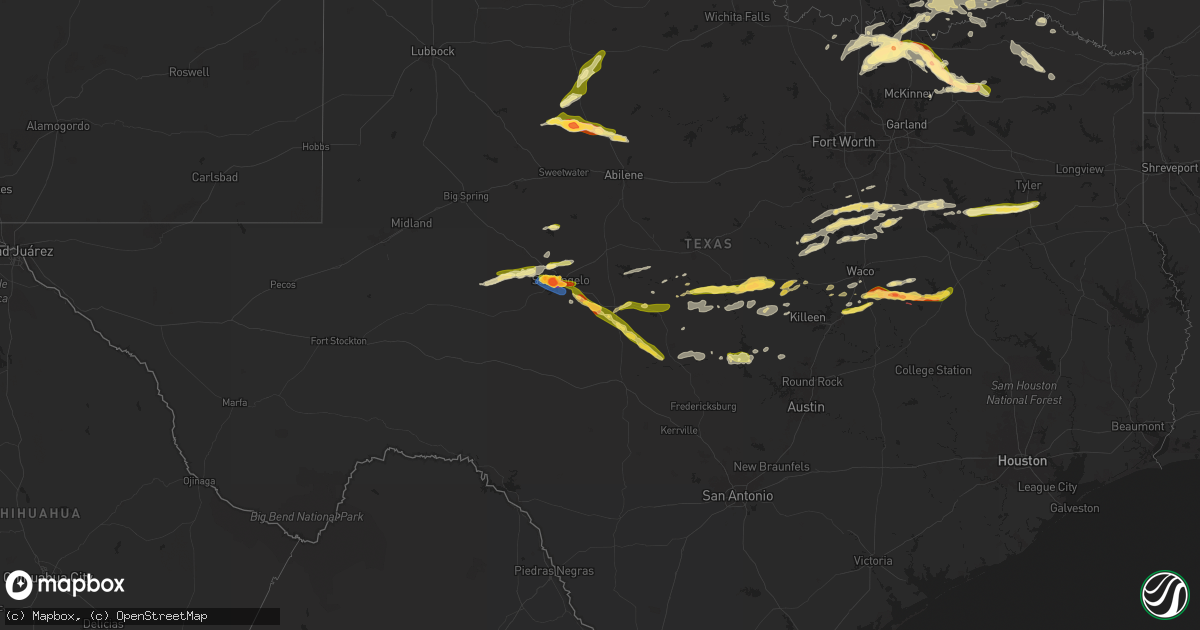
Hail Map in Texas on May 23, 2024
Get this storm
May 23 map
$229
one time, instant access
Download today. No call, no setup
Keep the $229
Bought the map and want the full workflow? Apply the entire $229 to a subscription within 7 days. None of it is wasted.
Every map, not just this one
This buys you this map. Subscription and you get every map we run, in the markets you choose from a few cities to whole states to nationwide. Plus real-time alerts the moment a storm fires.
Contact data
Name, contact info, occupancy, even credit band for addresses in the footprint. You go from where it hit to who to call.
Become the source they trust
Unlimited branding weather history reports on demand. You already have the documented answer ready for the property owner, and you are the one who showed up with it.
Property data and RoofTrace estimates
Pull up any address you have got, its value and the exact code rules for that jurisdiction, straight from One Click Code. Then RoofTrace estimates the squares, pitch, and roof value, priced the way you price.
Storm reports in Texas
Texas
| Date | Description |
|---|---|
| 05/23/20246:57 PM CDT | Golf ball size hail in kosse |
| 05/23/20246:57 PM CDT | Golf ball size hail in kosse. |
| 05/23/20246:45 PM CDT | Photos received from falls co fd of tornado on fm 413 east of reagan. Also confirmed by additional reports from storm spotters and emergency management as the tornado t |
| 05/23/20246:30 PM CDT | 2 inch hail on hwy 7 west of kosse. |
| 05/23/20246:14 PM CDT | Ef-0 damage was found near reagan and kossee with maximum estimated winds of 85 mph. |
| 05/23/20245:47 PM CDT | Ef-0 damage was found near chilton and marlin with maximum estimated winds of 85 mph. |
| 05/23/20245:35 PM CDT | Photos received of a damaged home and detached metal garage about 1.5 miles se of bruceville eddy near the county line. Time and location approximate. |
| 05/23/20245:28 PM CDT | *** 2 inj *** ef-1 damage was found southeast of bruceville with maximum estimated winds of 105 mph. |
| 05/23/20245:20 PM CDT | A local report indicates 2.75 inch wind near 4 W Hitson |
| 05/23/20245:11 PM CDT | Some hails stones slightly bigger than a quarter at the time of the report. |
| 05/23/20244:59 PM CDT | A local report indicates 2.50 inch wind near 4 SSW San Angelo |
| 05/23/20244:56 PM CDT | Asos station ksjt san angelo. |
| 05/23/20244:55 PM CDT | A local report indicates 2.75 inch wind near 2 SW San Angelo |
| 05/23/20244:52 PM CDT | A local report indicates 3.00 inch wind near 3 SW San Angelo |
| 05/23/20244:52 PM CDT | A local report indicates 3.00 inch wind near 3 SW San Angelo |
| 05/23/20244:50 PM CDT | A local report indicates 2.75 inch wind near 4 W San Angelo |
| 05/23/20244:48 PM CDT | Social media photo shows mostly quarter to ping pong size hail with a few stones near two inches in diameter. Location estimated. |
| 05/23/20244:48 PM CDT | Report from mping: hen egg |
| 05/23/20244:47 PM CDT | A local report indicates 1.75 inch wind near 2 W San Angelo |
| 05/23/20244:45 PM CDT | A lot of golf ball sized hail with a few bigger than baseballs. |
| 05/23/20244:43 PM CDT | Time estimated by radar. |
| 05/23/20244:42 PM CDT | Report from mping: golf ball |
| 05/23/20244:39 PM CDT | Report from mping: half dollar |
| 05/23/20244:38 PM CDT | Report from mping: ping pong ball |
| 05/23/20244:37 PM CDT | Report from mping: quarter |
| 05/23/202411:35 AM CDT | 1.25 inch hail reported east of troy on fm935. |
| 05/23/202411:13 AM CDT | A local report indicates 1.00 inch wind near Skeeterville |
| 05/23/20248:30 AM CDT | A local report indicates 1.00 inch wind near 1 S Grape Creek |
| 05/23/20241:45 AM CDT | Delayed report from mping: 3-inch tree limbs broken; power poles broken. |
| 05/23/202412:47 AM CDT | Report from mping: half dollar |
| 05/23/202412:38 AM CDT | Leonard vfd reported golf ball sized hail in the city of leonard. |
| 05/23/202412:34 AM CDT | Updates previous tstm wnd dmg report from leonard. Emergency management reports major tree damage in western portions of leonard near cottonwood st and n connett st. On |
| 05/23/202412:34 AM CDT | Emergency management reports significant tree damage within the city of leonard and its outskirts. |
| 05/23/202412:27 AM CDT | Trenton vfd reported quarter sized hail at fm 981 in between leonard and trenton. |
| 05/23/202412:17 AM CDT | Delayed report. Social media picture of ping pong sized hail in trenton. |
| 05/23/202412:02 AM CDT | Delayed report. Social media picture of 2-inch hail in whitewright. |
| 05/22/202411:50 PM CDT | Emergency management reported several large trees downed on cedar rd near snap rd in luella. |
| 05/22/202411:41 PM CDT | Emergency management reported several large trees downed on watkins road nw of luella. |
| 05/22/202411:32 PM CDT | Report from mping: half dollar |
| 05/22/202411:13 PM CDT | Spotter report of quarter-sized hail near fm 1417 and lamberth road intersection on the west side of sherman. |
| 05/22/202410:57 PM CDT | Report from mping: golf ball |
| 05/22/202410:49 PM CDT | Spotter report of quarter-sized hail near southmayd in grayson county. |
| 05/22/202410:38 PM CDT | Social media picture of golf ball sized hail in collinsville. |
| 05/22/202410:34 PM CDT | Emergency management reported ping pong ball sized hail in collinsville. |
| 05/22/202410:29 PM CDT | Social media picture of ping-pong ball sized hail in between whitesboro and collinsville. |
| 05/22/202410:25 PM CDT | Trained spotter picture of measured golf-ball sized hail. |
| 05/22/20248:20 PM CDT | Quarter hail near hwy 79/39. |
| 05/22/20248:15 PM CDT | Half dollar size hail on fm 1469 west of jewett. |
| 05/22/20247:29 PM CDT | Public social ne 4123 9598 tree fell on a home. |
| 05/22/20247:29 PM CDT | Public social media report of trees and large limbs down in emerald bay area. |
| 05/22/20247:25 PM CDT | Five miles east of menard on fm2092. |
| 05/22/20247:20 PM CDT | Emergency management and trained spotters confirm a multivortex tornado in progress along highway 7 near willow creek rd. |
| 05/22/20247:20 PM CDT | Bullard fire department reporting trees and power lines do |
| 05/22/20247:20 PM CDT | Bullard fire department reporting trees and power lines down. |
| 05/22/20247:15 PM CDT | Ef-0 damage was found in southern limestone and northern robertson counties with maximum estimated winds of 85 mph. |
| 05/22/20247:09 PM CDT | This is a continuation of the southeast henderson county tornado. This tornado moved across lake palestine as a waterspout as it crossed into extreme southwest smith co |
| 05/22/20247:06 PM CDT | Ef-1 damage was found in coffee city with maximum estimated winds of 105 mph. |
| 05/22/20247:04 PM CDT | Social media report of 1 inch hail in coffee city relayed by nws shv. |
| 05/22/20247:02 PM CDT | Damage to a number of buildings at lake palestine resort. Pictures relayed via nws shv. |
| 05/22/20247:00 PM CDT | Reported by a trained spotter/meteorologist in emerald bay community. |
All States Impacted by Hail Map on May 23, 2024
Cities Impacted by Hail Map on May 23, 2024
- Albany, KY
- Monticello, KY
- Alpha, KY
- Stoutland, MO
- Richland, MO
- Lebanon, MO
- Steelville, MO
- Mason, TX
- Glendale, KY
- Elizabethtown, KY
- Hodgenville, KY
- San Saba, TX
- Bonnieville, KY
- Ashdown, AR
- Wilton, AR
- Munfordville, KY
- Art, TX
- Castell, TX
- Llano, TX
- Pontotoc, TX
- Valley Spring, TX
- Canmer, KY
- Hardyville, KY
- Magnolia, KY
- New Haven, KY
- Ridgefield, CT
- North Salem, NY
- Eden, TX
- Loretto, KY
- New Hope, KY
- Brewster, NY
- Mertzon, TX
- Summersville, KY
- Greensburg, KY
- Danbury, CT
- Redding, CT
- Bethel, CT
- Sterling City, TX
- Melvin, TX
- Lebanon, KY
- Springfield, KY
- Easton, PA
- Stewartsville, NJ
- Campbellsville, KY
- Owensboro, KY
- Carlsbad, TX
- Buchanan Dam, TX
- Burnet, TX
- Kingsland, TX
- Brady, TX
- Asbury, NJ
- Adolphus, KY
- Scottsville, KY
- Westmoreland, TN
- Emmet, AR
- Rosston, AR
- Hope, AR
- Lohn, TX
- Rochelle, TX
- Marble Falls, TX
- Sag Harbor, NY
- Southampton, NY
- San Angelo, TX
- Pomona, NY
- Stony Point, NY
- Thiells, NY
- Bertram, TX
- Van Buren, MO
- East Hampton, NY
- Water Mill, NY
- Amawalk, NY
- Yorktown Heights, NY
- Katonah, NY
- Granite Springs, NY
- Croton Falls, NY
- Mahopac, NY
- Somers, NY
- Carmel, NY
- Bridgehampton, NY
- Sagaponack, NY
- Thornwood, NY
- Chappaqua, NY
- Pleasantville, NY
- Armonk, NY
- Putnam Valley, NY
- Cortlandt Manor, NY
- Mohegan Lake, NY
- Lake Peekskill, NY
- Tomkins Cove, NY
- Garnerville, NY
- West Haverstraw, NY
- Haverstraw, NY
- Croton On Hudson, NY
- Verplanck, NY
- Montrose, NY
- Buchanan, NY
- Peekskill, NY
- Liberty Hill, TX
- New City, NY
- Congers, NY
- Suffern, NY
- Richland Springs, TX
- Briarcliff Manor, NY
- Elmsford, NY
- White Plains, NY
- Millersview, TX
- North Kingstown, RI
- Jamestown, RI
- Saunderstown, RI
- Greenville, MO
- Lometa, TX
- Gouldbusk, TX
- Voss, TX
- Coleman, TX
- Marquand, MO
- Lampasas, TX
- Jewett City, CT
- Plainfield, CT
- Voluntown, CT
- Snow Lake, AR
- Baltic, CT
- Canterbury, CT
- Norwich, CT
- Shelter Island, NY
- Patton, MO
- Fredericktown, MO
- Saint Mary, MO
- Sainte Genevieve, MO
- Moosup, CT
- Perryville, MO
- South Salem, NY
- Kempner, TX
- Shrub Oak, NY
- Purdys, NY
- Goldthwaite, TX
- Shelter Island Heights, NY
- Copperas Cove, TX
- Star, TX
- Evant, TX
- Sparta, IL
- Chester, IL
- Steeleville, IL
- Rockwood, TX
- Percy, IL
- Cutler, IL
- Greenville, MS
- Belton, TX
- Temple, TX
- Moody, TX
- Gatesville, TX
- Campbell Hill, IL
- Troy, TX
- Lott, TX
- Eddy, TX
- Coulterville, IL
- Santa Anna, TX
- Oakdale, IL
- Pinckneyville, IL
- Purmela, TX
- Berlin, NH
- Milan, NH
- Benton, IL
- Christopher, IL
- Mulkeytown, IL
- Wilton, ME
- Anson, ME
- Nashville, IL
- Brookesmith, TX
- New Portland, ME
- Farmington, ME
- New Vineyard, ME
- North Anson, ME
- West Paris, ME
- Sesser, IL
- Madison, ME
- Sumner, ME
- Greenville, ME
- Claremont, SD
- Groton, SD
- Madisonville, KY
- Dawson Springs, KY
- Earlington, KY
- Sharon Grove, KY
- Oglesby, TX
- Lewisburg, KY
- Brownville, ME
- McGregor, TX
- Russellville, KY
- Portage, ME
- Huntsville, AL
- Gurley, AL
- Brooks, ME
- Augusta, ME
- Lorena, TX
- Auburn, KY
- Morgantown, KY
- Bruceville, TX
- Jonesboro, TX
- Clifton, TX
- Washburn, ME
- Waco, TX
- Hampden, ME
- Carmel, ME
- New Market, AL
- Hewitt, TX
- Chilton, TX
- Bridgewater, ME
- Rumsey, KY
- Sacramento, KY
- Celina, TN
- Byrdstown, TN
- Burkesville, KY
- Mapleton, ME
- Riesel, TX
- Westfield, ME
- Presque Isle, ME
- Sherman, ME
- Benedicta, ME
- Stacyville, ME
- Cranfills Gap, TX
- Meridian, TX
- Franklin, KY
- Whitney, TX
- Abbott, TX
- Houlton, ME
- Calhoun, GA
- Sugar Valley, GA
- Aquilla, TX
- Alvaton, KY
- Plainville, GA
- Armuchee, GA
- Resaca, GA
- Morgan, TX
- Austin, KY
- Fountain Run, KY
- Penelope, TX
- West, TX
- Hillsboro, TX
- Orient, ME
- Strasburg, VA
- Toms Brook, VA
- Buckfield, ME
- Forbes, ND
- Jay, ME
- Leola, SD
- Carthage, TN
- Blum, TX
- Kopperl, TX
- Covington, TX
- Lisco, NE
- Presho, SD
- Hestand, KY
- Faulkton, SD
- Fort Thompson, SD
- Newcastle, OK
- Highmore, SD
- Malone, TX
- Bynum, TX
- Ellendale, ND
- Tompkinsville, KY
- Mustang, OK
- Yukon, OK
- Oklahoma City, OK
- Bethany, OK
- Fullerton, ND
- Oshkosh, NE
- Itasca, TX
- Frost, TX
- Mertens, TX
- Rotan, TX
- Stephan, SD
- Moss, TN
- Orient, SD
- Seneca, SD
- Arthur, NE
- Ashby, NE
- Frederick, SD
- Allons, TN
- Milford, TX
- Lamoure, ND
- Italy, TX
- Robert Lee, TX
- Cresbard, SD
- Wellington, TX
- Childress, TX
- Lodgepole, NE
- Dodson, TX
- Grandview, TX
- Edmond, OK
- Lewellen, NE
- Goodfellow Afb, TX
- Wood, SD
- Bronte, TX
- Strasburg, ND
- White River, SD
- Mission, SD
- Hamlin, TX
- Lower Brule, SD
- Ipswich, SD
- Spencer, OK
- Aspermont, TX
- Fort Yates, ND
- Maypearl, TX
- Erick, OK
- Texola, OK
- Linton, ND
- Jones, OK
- Oakes, ND
- Aberdeen, SD
- Old Glory, TX
- Mansfield, SD
- Harrold, SD
- Ree Heights, SD
- Miller, SD
- Blooming Grove, TX
- Catawba, NC
- Waxahachie, TX
- Paducah, TX
- Hollis, OK
- Bingham, NE
- Vancourt, TX
- Wall, TX
- Point Of Rocks, MD
- Adamstown, MD
- Tuscarora, MD
- Jefferson, MD
- Big Springs, NE
- Chappell, NE
- Cogswell, ND
- Saint Francis, SD
- Leesburg, VA
- Lovettsville, VA
- Corsicana, TX
- Barry, TX
- Waterford, VA
- Hague, ND
- Sherrills Ford, NC
- Draper, SD
- Rice, TX
- Seymour, TX
- Gould, OK
- Forman, ND
- McCaulley, TX
- Hamilton, VA
- Purcellville, VA
- Kintyre, ND
- Roscoe, SD
- Marlin, TX
- Ashburn, VA
- Powell, TX
- Dickerson, MD
- Roby, TX
- Frederick, MD
- Ijamsville, MD
- Merriman, NE
- Napoleon, ND
- Wishek, ND
- Cheyenne, OK
- Sterling, VA
- Cody, NE
- Kerens, TX
- Winner, SD
- Anson, TX
- Stamford, TX
- Valentine, NE
- Reeder, ND
- Holabird, SD
- Fredonia, ND
- Menard, TX
- Herndon, VA
- Brule, NE
- Duke, OK
- Hettinger, ND
- Kosse, TX
- Athens, TX
- Malakoff, TX
- Saint Lawrence, SD
- Sayre, OK
- Mangum, OK
- Vinson, OK
- Willow, OK
- Trinidad, TX
- Eldorado, OK
- Witten, SD
- Reston, VA
- Reagan, TX
- Lemoyne, NE
- Bethlehem, PA
- Wessington, SD
- Streeter, ND
- Gackle, ND
- Kulm, ND
- Concord, NC
- Rockwell, NC
- Kannapolis, NC
- Larue, TX
- Athens, TN
- Zeeland, ND
- Ogallala, NE
- Thornton, TX
- Groesbeck, TX
- Crookston, NE
- Keystone, NE
- Grant, NE
- Venango, NE
- Frankston, TX
- Chandler, TX
- Flint, TX
- Bullard, TX
- Tulare, SD
- Hitchcock, SD
- Rockham, SD
- Redfield, SD
- Ashton, SD
- Lehr, ND
- Ashley, ND
- Dupree, SD
- Franklin, TX
- Altus, OK
- Olustee, OK
- Reisterstown, MD
- Owings Mills, MD
- Onaka, SD
- Jud, ND
- Montpelier, ND
- Fort Pierre, SD
- Pierre, SD
- Madrid, NE
- Paxton, NE
- Troup, TX
- Whitehouse, TX
- Tyler, TX
- Onida, SD
- Keldron, SD
- Lemmon, SD
- Elsie, NE
- Hext, TX
- Crossville, TN
- Crab Orchard, TN
- Rockwood, TN
- Sutherland, NE
- Morristown, SD
- Agar, SD
- Middletown, VA
- Stephens City, VA
- Front Royal, VA
- Woodstock, VA
- El Dorado, KS
- Augusta, KS
- Leon, KS
- Frankfort, SD
- Mott, ND
- New Leipzig, ND
- Gettysburg, SD
- Wallace, NE
- Imperial, NE
- Wauneta, NE
- Hickory, NC
- Cassoday, KS
- Spring Grove, PA
- Seven Valleys, PA
- Marquez, TX
- Enders, NE
- Hayes Center, NE
- Altus Afb, OK
- Marble, NC
- Jewett, TX
- Red Lion, PA
- Dallastown, PA
- York, PA
- Elmer, OK
- Glen Rock, PA
- Burns, KS
- Andrews, NC
- Murphy, NC
- Herreid, SD
- Headrick, OK
- Hoven, SD
- Selby, SD
- Blair, OK
- Emporia, KS
- Cottonwood Falls, KS
- Hershey, NE
- Tellico Plains, TN
- Warne, NC
- Brasstown, NC
- Benkelman, NE
- Palisade, NE
- Dickens, NE
- Hayesville, NC
- Stratton, NE
- Java, SD
- Mound City, SD
- Robbinsville, NC
- Americus, KS
- North Platte, NE
- Maxwell, NE
- Trenton, NE
- Culbertson, NE
- Bassett, NE
- Snyder, OK
- Mountain Park, OK
- Tipton, OK
- Max, NE
- Mount Pleasant, NC
- Wellfleet, NE
- Maywood, NE
- McCook, NE
- Roosevelt, OK
- Indianola, NE
- Burwell, NE
- Valley View, TX
- Lawton, OK
- Frederick, OK
- Sanger, TX
- Hendrix, OK
- Durant, OK
- Calera, OK
- Era, TX
- Gainesville, TX
- Curtis, NE
- Oberlin, KS
- Indiahoma, OK
- Forestburg, TX
- Saint Jo, TX
- Bartley, NE
- Muenster, TX
- Danbury, NE
- Stockville, NE
- Collinsville, TX
- Tioga, TX
- Bokchito, OK
- Pilot Point, TX
- Wylie, TX
- Allen, TX
- Cambridge, NE
- Whitesboro, TX
- Caddo, OK
- Lindsay, TX
- Princeton, TX
- Comstock, NE
- Cozad, NE
- Elgin, OK
- Moorefield, NE
- Lebanon, NE
- Howe, TX
- Eustis, NE
- Glen Ullin, ND
- Elgin, ND
- Sherman, TX
- Pottsboro, TX
- Gunter, TX
- Farmersville, TX
- Wilsonville, NE
- Cyril, OK
- Fletcher, OK
- Apache, OK
- Cache, OK
- Atwood, KS
- Herndon, KS
- Mead, OK
- Cartwright, OK
- Denison, TX
- Colbert, OK
- Holbrook, NE
- Thackerville, OK
- Sadler, TX
- Arapahoe, NE
- Eddyville, NE
- Cement, OK
- Lexington, NE
- Norcatur, KS
- Hendley, NE
- Fort Sill, OK
- Greenville, TX
- Celeste, TX
- Oconto, NE
- Sumner, NE
- Mason City, NE
- Bennington, OK
- Boswell, OK
- Edison, NE
- Beaver City, NE
- Ninnekah, OK
- Rush Springs, OK
- Elwood, NE
- Bartlett, NE
- Madill, OK
- Wolfe City, TX
- Oxford, NE
- Elm Creek, NE
- Miller, NE
- Amherst, NE
- Overton, NE
- Neligh, NE
- Litchfield, NE
- Marlow, OK
- Gordonville, TX
- Bells, TX
- Farnam, NE
- Smithfield, NE
- Loomis, NE
- Bertrand, NE
- Holdrege, NE
- Kearney, NE
- Funk, NE
- Orleans, NE
- Atlanta, NE
- Stamford, NE
- Whitewright, TX
- Plainview, NE
- Lindsay, OK
- Foster, OK
- Loup City, NE
- Ravenna, NE
- Commerce, TX
- Spalding, NE
- Greeley, NE
- Soper, OK
- Hugo, OK
- Duncan, OK
- Savoy, TX
- Ector, TX
- Bonham, TX
- Pleasanton, NE
- Hazard, NE
- Elba, NE
- Saint Paul, NE
- Klondike, TX
- Scotia, NE
- Almena, KS
- Rockville, NE
- Ashton, NE
- Dannebrog, NE
- Oakdale, NE
- Farwell, NE
- Wolbach, NE
- Tilden, NE
- Alma, NE
- Republican City, NE
- Phillipsburg, KS
- Axtell, NE
- Wilcox, NE
- Hildreth, NE
- Franklin, NE
- Riverton, NE
- Bloomington, NE
- Naponee, NE
- Agra, KS
- Riverdale, NE
- Upland, NE
- Minden, NE
- Odessa, NE
- Gibbon, NE
- Heartwell, NE
- Atoka, OK
- Boelus, NE
- Albion, NE
- Van Alstyne, TX
- Trenton, TX
- Osmond, NE
- Logan, KS
- Cairo, NE
- Hill City, KS
- Primrose, NE
- Prairie View, KS
- Lane, OK
- Elmore City, OK
- Tussy, OK
- Ratliff City, OK
- Hennepin, OK
- Randolph, TX
- Leonard, TX
- Inavale, NE
- Kenesaw, NE
- Campbell, NE
- Shelton, NE
- Red Cloud, NE
- Bladen, NE
- Holstein, NE
- Wood River, NE
- Ayr, NE
- Juniata, NE
- Blue Hill, NE
- Doniphan, NE
- Hastings, NE
- Roseland, NE
- Stockton, KS
- Bogue, KS
- Palmer, NE
- Alda, NE
- Cedar Rapids, NE
- Fullerton, NE
- Saint Libory, NE
- Belgrade, NE
- Trumbull, NE
- Grand Island, NE
- Phillips, NE
- Chapman, NE
- Pierce, NE
- Hamilton, MO
- Kidder, MO
- Cameron, MO
- North Loup, NE
- Palco, KS
- Springer, OK
- Wynnewood, OK
- Davis, OK
- Aurora, NE
- Marquette, NE
- Clay Center, NE
- Saint Edward, NE
- Giltner, NE
- Inland, NE
- Deweese, NE
- Harvard, NE
- Archer, NE
- Central City, NE
- Guide Rock, NE
- Lawrence, NE
- Glenvil, NE
- Fairfield, NE
- Lindsay, NE
- Newman Grove, NE
- Clarks, NE
- Nelson, NE
- Genoa, NE
- Hordville, NE
- Silver Creek, NE
- Glade, KS
- Ellis, KS
- Ogallah, KS
- Damar, KS
- Randolph, NE
- Gallatin, MO
- Breckenridge, MO
- Saronville, NE
- Polk, NE
- Hampton, NE
- Ong, NE
- Oak, NE
- Edgar, NE
- Superior, NE
- Sutton, NE
- Henderson, NE
- Columbus, NE
- Madison, NE
- Norfolk, NE
- Bradshaw, NE
- Stromsburg, NE
- Monroe, NE
- Platte Center, NE
- Osceola, NE
- Benedict, NE
- Humphrey, NE
- Ardmore, OK
- Roff, OK
- Sulphur, OK
- Dougherty, OK
- Shickley, NE
- Strang, NE
- Byron, NE
- Hebron, NE
- McCool Junction, NE
- Fairmont, NE
- Ruskin, NE
- Geneva, NE
- Davenport, NE
- Deshler, NE
- Grafton, NE
- Carleton, NE
- York, NE
- Hardy, NE
- Shelby, NE
- Waco, NE
- Bruning, NE
- Creston, NE
- Duncan, NE
- Stanton, NE
- Gresham, NE
- Lock Springs, MO
- Jamesport, MO
- Brady, NE
- Honey Grove, TX
- Sumner, TX
- Chillicothe, MO
- Beresford, SD
- Centerville, SD
- Ainsworth, NE
- Gothenburg, NE
- Cumby, TX
- Campbell, TX
- Mill Creek, OK
- Stonewall, OK
- Mannsville, OK
- Tishomingo, OK
- Belvidere, NE
- Ohiowa, NE
- Rising City, NE
- David City, NE
- Surprise, NE
- Pilger, NE
- Leigh, NE
- Beaver Crossing, NE
- Milligan, NE
- Wisner, NE
- Schuyler, NE
- Howells, NE
- Clarkson, NE
- Bellwood, NE
- Exeter, NE
- Utica, NE
- Staplehurst, NE
- Ulysses, NE
- Hudson, SD
- Rock Valley, IA
- Bagwell, TX
- Boyden, IA
- Sac City, IA
- Anna, TX
- Trenton, MO
- Newcastle, NE
- Dixon, NE
- Nemaha, IA
- Newell, IA
- Storm Lake, IA
- Everly, IA
- Daykin, NE
- Cordova, NE
- Western, NE
- Dodge, NE
- Seward, NE
- Friend, NE
- Milford, NE
- Bee, NE
- Tobias, NE
- Dorchester, NE
- Brainard, NE
- Linwood, NE
- Alexandria, NE
- Gilead, NE
- Dwight, NE
- Fairbury, NE
- Goehner, NE
- Bruno, NE
- Prague, NE
- Beemer, NE
- Scribner, NE
- Morse Bluff, NE
- Snyder, NE
- Bancroft, NE
- Wilber, NE
- North Bend, NE
- Garland, NE
- Abie, NE
- Crete, NE
- Rogers, NE
- West Point, NE
- Pender, NE
- Sulphur Springs, TX
- Milburn, OK
- Coleman, OK
- Wapanucka, OK
- Newtown, MO
- Milford, IA
- Lebanon, SD
- Clarksville, TX
- Eureka, SD
- Chester, NE
- Hubbell, NE
- Swanton, NE
- Pleasant Dale, NE
- Weston, NE
- Plymouth, NE
- Valparaiso, NE
- Roca, NE
- Davey, NE
- De Witt, NE
- Denton, NE
- Cortland, NE
- Raymond, NE
- Pickrell, NE
- Hallam, NE
- Ceresco, NE
- Jansen, NE
- Martell, NE
- Wahoo, NE
- Lincoln, NE
- Clatonia, NE
- Sprague, NE
- Malcolm, NE
- Beatrice, NE
- Malmo, NE
- Cedar Bluffs, NE
- Firth, NE
- Valley, NE
- Colon, NE
- Waverly, NE
- Hickman, NE
- Oakland, NE
- Hooper, NE
- Ames, NE
- Yutan, NE
- Fremont, NE
- Mead, NE
- Winslow, NE
- Ithaca, NE
- Ashland, NE
- Nickerson, NE
- Rosalie, NE
- Lyons, NE
- Herman, NE
- Uehling, NE
- Craig, NE
- Arlington, NE
- Lake City, IA
- Spirit Lake, IA
- George, IA
- Kenefic, OK
- Lake Park, IA
- Spickard, MO
- Albert City, IA
- Marathon, IA
- Rembrandt, IA
- Akron, IA
- Pollock, MO
- Lucerne, MO
- Unionville, MO
- Rock Rapids, IA
- Doon, IA
- Eagle, NE
- Greenwood, NE
- Adams, NE
- Panama, NE
- Walton, NE
- Filley, NE
- Alvo, NE
- Bennet, NE
- Memphis, NE
- Palmyra, NE
- Elmwood, NE
- Cedar Creek, NE
- Springfield, NE
- Louisville, NE
- Gretna, NE
- Sterling, NE
- Tecumseh, NE
- Papillion, NE
- Omaha, NE
- La Vista, NE
- Murdock, NE
- Weeping Water, NE
- South Bend, NE
- Waterloo, NE
- Elkhorn, NE
- Unadilla, NE
- Avoca, NE
- Douglas, NE
- Fort Calhoun, NE
- Kennard, NE
- Blair, NE
- Decatur, NE
- Washington, NE
- Missouri Valley, IA
- Bennington, NE
- Boys Town, NE
- Modale, IA
- Tekamah, NE
- Mondamin, IA
- Onawa, IA
- Winnebago, NE
- Macy, NE
- Walthill, NE
- Little Sioux, IA
- Whiting, IA
- Blencoe, IA
- Sloan, IA
- Rockwell City, IA
- Jackson, MN
- Princeton, MO
- Galt, MO
- Ceylon, MN
- Dolliver, IA
- Fairmont, MN
- Harris, MO
- Sioux Rapids, IA
- Eagleville, MO
- Green Castle, MO
- Novinger, MO
- Caney, OK
- Burr, NE
- Manley, NE
- Otoe, NE
- Syracuse, NE
- Elk Creek, NE
- Crab Orchard, NE
- Cook, NE
- Pisgah, IA
- Hornick, IA
- Nebraska City, NE
- Union, NE
- Crescent, IA
- Offutt Afb, NE
- Council Bluffs, IA
- Nehawka, NE
- Pacific Junction, IA
- Talmage, NE
- Plattsmouth, NE
- Carter Lake, IA
- Lorton, NE
- Murray, NE
- Bellevue, NE
- Dunbar, NE
- Blythedale, MO
- Glidden, IA
- Ridgeway, MO
- Carroll, IA
- Sherburn, MN
- Welcome, MN
- Greenville, IA
- Webb, IA
- Windom, MN
- Bingham Lake, MN
- Bonnerdale, AR
- Cincinnati, IA
- Centerville, IA
- Brock, NE
- Steinauer, NE
- Pawnee City, NE
- Odell, NE
- Liberty, NE
- Virginia, NE
- Blue Springs, NE
- Lewiston, NE
- Diller, NE
- Burchard, NE
- Reynolds, NE
- Thurman, IA
- Tabor, IA
- Hastings, IA
- Malvern, IA
- Mineola, IA
- Percival, IA
- Johnson, NE
- Sidney, IA
- Silver City, IA
- Glenwood, IA
- Underwood, IA
- Neola, IA
- Minden, IA
- Castana, IA
- Woodbine, IA
- Macedonia, IA
- Treynor, IA
- Magnolia, IA
- Moorhead, IA
- McClelland, IA
- Honey Creek, IA
- Logan, IA
- Henderson, IA
- Rodney, IA
- Oto, IA
- Dunlap, IA
- Mapleton, IA
- Ute, IA
- Persia, IA
- Soldier, IA
- Smithland, IA
- Le Mars, IA
- Hull, IA
- Davis City, IA
- Spencer, IA
- Decatur, IA
- Lamoni, IA
- Leon, IA
- Rolfe, IA
- West Bend, IA
- Reading, MN
- Brewster, MN
- Worthington, MN
- Moulton, IA
- Mountain Lake, MN
- Julian, NE
- Rock Port, MO
- Randolph, IA
- Hamburg, IA
- Peru, NE
- Table Rock, NE
- Auburn, NE
- Humboldt, NE
- Shenandoah, IA
- Essex, IA
- Watson, MO
- Imogene, IA
- Brownville, NE
- Carson, IA
- Riverton, IA
- Farragut, IA
- Emerson, IA
- Red Oak, IA
- Portsmouth, IA
- Harlan, IA
- Panama, IA
- Oakland, IA
- Walnut, IA
- Elliott, IA
- Shelby, IA
- Hancock, IA
- Avoca, IA
- Griswold, IA
- Drakesville, IA
- Hampton, IA
- Aredale, IA
- Sheffield, IA
- Newton, IA
- Baxter, IA
- Udell, IA
- Unionville, IA
- Antlers, OK
- Fostoria, IA
- Palmer, IA
- Pocahontas, IA
- Moravia, IA
- Powersville, MO
- Oyens, IA
- Remsen, IA
- Blakesburg, IA
- Danbury, IA
- Westphalia, IA
- Earling, IA
- Defiance, IA
- Battle Creek, IA
- Kirkman, IA
- Manilla, IA
- Arion, IA
- Charter Oak, IA
- Denison, IA
- Schleswig, IA
- Ricketts, IA
- Dow City, IA
- Harris, IA
- Fort Towson, OK
- Spencerville, OK
- Sawyer, OK
- Glenwood, AR
- Allerton, IA
- Corydon, IA
- Dougherty, IA
- Garvin, OK
- Arnolds Park, IA
- Okoboji, IA
- Dickens, IA
- New Boston, TX
- De Kalb, TX
- Ottumwa, IA
- Rhodes, IA
- Cambridge, IA
- Conrad, IA
- Foreman, AR
- Telephone, TX
- Arthur City, TX
- Eldora, IA
- Belle Plaine, IA
- Terril, IA
- Gillett Grove, IA
- Garden Grove, IA
- Lonoke, AR
- Humeston, IA
- Fairfax, MO
- Nemaha, NE
- Stella, NE
- Shubert, NE
- Tarkio, MO
- Northboro, IA
- Westboro, MO
- Coin, IA
- Clarinda, IA
- Blanchard, IA
- Grant, IA
- Carbon, IA
- Nodaway, IA
- Villisca, IA
- Yorktown, IA
- Corning, IA
- Stanton, IA
- Cumberland, IA
- Marne, IA
- Lewis, IA
- Brayton, IA
- Wiota, IA
- Irwin, IA
- Bridgewater, IA
- Audubon, IA
- Exira, IA
- Manning, IA
- Anita, IA
- Massena, IA
- Kimballton, IA
- Elk Horn, IA
- Atlantic, IA
- Templeton, IA
- Aspinwall, IA
- Gray, IA
- Hamlin, IA
- Westside, IA
- Vail, IA
- Nevada, IA
- Elberon, IA
- Ruthven, IA
- Ayrshire, IA
- State Center, IA
- Melbourne, IA
- Curlew, IA
- Eddyville, IA
- Saint Anthony, IA
- Woodburn, IA
- Colo, IA
- Elmo, MO
- College Springs, IA
- New Market, IA
- Adair, IA
- Creston, IA
- Greenfield, IA
- Fontanelle, IA
- Orient, IA
- Prescott, IA
- Chariton, IA
- Derby, IA
- Ollie, IA
- Richland, IA
- Batavia, IA
- Hedrick, IA
- Sigourney, IA
- Packwood, IA
- Lineville, IA
- New Virginia, IA
- McCallsburg, IA
- Allison, IA
- Clarksville, IA
- Clutier, IA
- Keystone, IA
- Dysart, IA
- Zearing, IA
- Scarville, IA
- Kiester, MN
- Amity, AR
- Lakefield, MN
- Cainsville, MO
- Lucas, IA
- Lenox, IA
- Sharpsburg, IA
- Gravity, IA
- Cromwell, IA
- Bedford, IA
- Shambaugh, IA
- Braddyville, IA
- Stuart, IA
- Guthrie Center, IA
- Menlo, IA
- Coon Rapids, IA
- Casey, IA
- Deloit, IA
- Halbur, IA
- Scranton, IA
- Bagley, IA
- Ida Grove, IA
- Kiron, IA
- Breda, IA
- Ralston, IA
- Dedham, IA
- Panora, IA
- Lidderdale, IA
- Arcadia, IA
- Bayard, IA
- Royal, IA
- Mercer, MO
- Keota, IA
- Bricelyn, MN
- Holland, IA
- Greene, IA
- Marshalltown, IA
- Grundy Center, IA
- Estherville, IA
- Harper, IA
- Wellsburg, IA
- Russell, IA
- Lorimor, IA
- Afton, IA
- Thayer, IA
- Dexter, IA
- Macksburg, IA
- Winterset, IA
- Murray, IA
- Peru, IA
- Rippey, IA
- Adel, IA
- Perry, IA
- Redfield, IA
- Minburn, IA
- Dawson, IA
- Linden, IA
- Earlham, IA
- Jefferson, IA
- Churdan, IA
- Grand Junction, IA
- Yale, IA
- Jamaica, IA
- Weldon, IA
- Nashua, IA
- Charles City, IA
- Wellman, IA
- Albion, IA
- Parkersburg, IA
- Havelock, IA
- Washington, IA
- Blossom, TX
- Paris, TX
- Pattonville, TX
- Lockridge, IA
- Mount Pleasant, IA
- Osceola, IA
- Alden, IA
- Winnebago, MN
- Delavan, MN
- Indianola, IA
- La Porte City, IA
- Laurens, IA
- Wayland, IA
- Truro, IA
- Van Meter, IA
- Dallas Center, IA
- Prole, IA
- De Soto, IA
- Saint Charles, IA
- Patterson, IA
- Waukee, IA
- Bouton, IA
- Ogden, IA
- Beaver, IA
- Booneville, IA
- Woodward, IA
- Waterloo, IA
- Jesup, IA
- Gilbertville, IA
- Evansdale, IA
- Raymond, IA
- Lovilia, IA
- Melrose, IA
- Ainsworth, IA
- Deport, TX
- Bogata, TX
- Detroit, TX
- Riverside, IA
- Mallard, IA
- Moorland, IA
- Somers, IA
- Alden, MN
- Wells, MN
- Milo, IA
- Oxford, IA
- Williamsburg, IA
- Kalona, IA
- North Liberty, IA
- Parnell, IA
- Amboy, MN
- Cumming, IA
- Ellston, IA
- Diagonal, IA
- Norwalk, IA
- Shannon City, IA
- Tingley, IA
- Clearfield, IA
- Lacona, IA
- Bevington, IA
- Johnston, IA
- Saint Marys, IA
- Granger, IA
- Carlisle, IA
- Liberty Center, IA
- Windsor Heights, IA
- Urbandale, IA
- Madrid, IA
- Grimes, IA
- Clive, IA
- Des Moines, IA
- Martensdale, IA
- Pleasantville, IA
- West Des Moines, IA
- Ackworth, IA
- Ankeny, IA
- Berwick, IA
- Boone, IA
- Polk City, IA
- Hartford, IA
- Runnells, IA
- Swan, IA
- Altoona, IA
- Pleasant Hill, IA
- Elkhart, IA
- Mitchellville, IA
- Alleman, IA
- Slater, IA
- Luther, IA
- Prairie City, IA
- Bondurant, IA
- Huxley, IA
- Ames, IA
- Kelley, IA
- Sheldahl, IA
- Cedar Rapids, IA
- Ely, IA
- Solon, IA
- Swisher, IA
- Columbus Junction, IA
- Iowa Falls, IA
- Emmetsburg, IA
- Conesville, IA
- Plainfield, IA
- Ionia, IA
- Iowa City, IA
- Coralville, IA
- Whittemore, IA
- Cylinder, IA
- Grand River, IA
- Melcher Dallas, IA
- Columbia, IA
- Knoxville, IA
- Otley, IA
- Colfax, IA
- Monroe, IA
- Ira, IA
- Maxwell, IA
- Mingo, IA
- Collins, IA
- Roland, IA
- New Hampton, IA
- West Branch, IA
- Fremont, IA
- Kirkville, IA
- Cedar, IA
- Chillicothe, IA
- Mount Vernon, IA
- Marion, IA
- Hamilton, IA
- West Liberty, IA
- Fenton, IA
- Bussey, IA
- Talco, TX
- Mount Pleasant, TX
- Oskaloosa, IA
- Dunkerton, IA
- University Park, IA
- Albia, IA
- Readlyn, IA
- Denver, IA
- Rose Hill, IA
- Tipton, IA
- Springville, IA
- Atalissa, IA
- Belmond, IA
- Central City, IA
- Tracy, IA
- Mechanicsville, IA
- Lisbon, IA
- Laurel, IA
- Clemons, IA
- Reasnor, IA
- Union, IA
- Haverhill, IA
- Killduff, IA
- Pella, IA
- Gilman, IA
- Lynnville, IA
- Sully, IA
- Grinnell, IA
- Kellogg, IA
- Ferguson, IA
- Harvey, IA
- New Providence, IA
- Williams, IA
- Bradford, IA
- Hubbard, IA
- Ellsworth, IA
- Radcliffe, IA
- Story City, IA
- Garden City, IA
- Jewell, IA
- Stratford, IA
- Gilbert, IA
- Kamrar, IA
- Paton, IA
- Pilot Mound, IA
- Randall, IA
- Blairsburg, IA
- Stanhope, IA
- Dana, IA
- Boxholm, IA
- Steamboat Rock, IA
- Whitten, IA
- Ackley, IA
- Geneva, IA
- Leighton, IA
- Liscomb, IA
- Williamson, IA
- Beacon, IA
- New Sharon, IA
- Searsboro, IA
- Montezuma, IA
- Aplington, IA
- Traer, IA
- Toledo, IA
- Barnes City, IA
- Beaman, IA
- Lincoln, IA
- Malcom, IA
- Garwin, IA
- Montour, IA
- Austinville, IA
- Le Grand, IA
- Gladbrook, IA
- Tama, IA
- Brooklyn, IA
- What Cheer, IA
- Chelsea, IA
- Sumner, IA
- Tripoli, IA
- Fairbank, IA
- Dewar, IA
- Lowden, IA
- Bennett, IA
- Clarence, IA
- Coldwater, MS
- Clarion, IA
- Rowan, IA
- Goodell, IA
- Rockwell, IA
- Swaledale, IA
- Fonda, IA
- Klemme, IA
- Hudson, IA
- Millerton, IA
- Thornton, IA
- Latimer, IA
- Delta, IA
- Keswick, IA
- Deep River, IA
- Gibson, IA
- Reinbeck, IA
- Dumont, IA
- Potts Camp, MS
- Millington, TN
- Clear Lake, IA
- Waverly, IA
- Maurertown, VA
- Chapin, IA
- Ventura, IA
- Garner, IA
- Paeonian Springs, VA
- Promise City, IA
- Northwood, IA
- Mason City, IA
- Hanlontown, IA
- Kesley, IA
- Manly, IA
- Kensett, IA
- Rockford, IA
- Bristow, IA
- Marble Rock, IA
- Nora Springs, IA
- Coulter, IA
- Harcourt, IA
- Alexander, IA
- Burnside, IA
- Dayton, IA
- Webster City, IA
- Fort Dodge, IA
- Duncombe, IA
- Lehigh, IA
- Dows, IA
- Meservey, IA
- Otho, IA
- Popejoy, IA
- Woolstock, IA
- Hardy, IA
- Lohrville, IA
- Thor, IA
- Vincent, IA
- Callender, IA
- Goldfield, IA
- Eagle Grove, IA
- Kanawha, IA
- Fertile, IA
- Galt, IA
- Farnhamville, IA
- Gowrie, IA
- Badger, IA
- Lake View, IA
- Arthur, IA
- Lytton, IA
- Odebolt, IA
- Knierim, IA
- Lanesboro, IA
- Manson, IA
- Barnum, IA
- Auburn, IA
- Wall Lake, IA
- Clare, IA
- Renwick, IA
- Forest City, IA
- Joice, IA
- Humboldt, IA
- Britt, IA
- Cordova, TN
- Memphis, TN
- Drummonds, TN
- Hickory Flat, MS
- Rison, AR
- Webster, IA
- Plymouth, IA
- Osage, IA
- Glenville, MN
- Rock Falls, IA
- Rudd, IA
- Lyle, MN
- Saint Ansgar, IA
- Carpenter, IA
- Grafton, IA
- Floyd, IA
- Orchard, IA
- New Hartford, IA
- Janesville, IA
- Dike, IA
- Stout, IA
- Morrison, IA
- Shell Rock, IA
- Cedar Falls, IA
- Guernsey, IA
- Ladora, IA
- Blairstown, IA
- Hartwick, IA
- Hayesville, IA
- Vining, IA
- Martinsburg, IA
- North English, IA
- Van Horne, IA
- Victor, IA
- Luzerne, IA
- Marengo, IA
- Millersburg, IA
- South English, IA
- Fairfield, IA
- Elma, IA
- Colwell, IA
- Stacyville, IA
- Alta Vista, IA
- Riceville, IA
- Little Cedar, IA
- Frederika, IA
- Arlington, TN
- Blue Mountain, MS
- Byhalia, MS
- Olive Branch, MS
- Ashland, MS
- Ripley, MS
- Conroy, IA
- Brighton, IA
- West Chester, IA
- Watkins, IA
- South Amana, IA
- Middle Amana, IA
- Newhall, IA
- Homestead, IA
- Amana, IA
- Norway, IA
- Fredericksburg, IA
- Shellsburg, IA
- Atkins, IA
- Collierville, TN
- Vinton, IA
- Oakland, TN
- Somerville, TN
- Center Point, IA
- Fairfax, IA
- Toddville, IA
- Palo, IA
- Walford, IA
- Olds, IA
- Tiffin, IA
- Crawfordsville, IA
- Hiawatha, IA
- Winfield, IA
- Lafe, AR
- Marmaduke, AR
- Eads, TN
- Winthrop, IA
- Rowley, IA
- Coggon, IA
- Independence, IA
- Walker, IA
- Quasqueton, IA
- Worthington, MO
- Corinth, MS
- Walnut, MS
- Whiteville, TN
- Lone Tree, IA
- Germantown, TN
- Jonesboro, AR
- Bono, AR
- Pocahontas, AR
- Maynard, AR
- Plano, IA
- Paint Rock, TX


