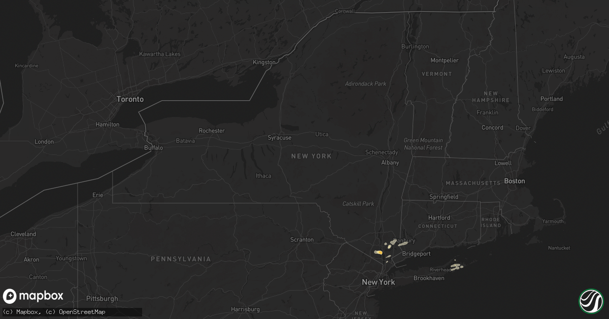
Hail Map in New York on May 23, 2024
Get this storm
May 23 map
$229
one time, instant access
Download today. No call, no setup
Keep the $229
Bought the map and want the full workflow? Apply the entire $229 to a subscription within 7 days. None of it is wasted.
Every map, not just this one
This buys you this map. Subscription and you get every map we run, in the markets you choose from a few cities to whole states to nationwide. Plus real-time alerts the moment a storm fires.
Contact data
Name, contact info, occupancy, even credit band for addresses in the footprint. You go from where it hit to who to call.
Become the source they trust
Unlimited branding weather history reports on demand. You already have the documented answer ready for the property owner, and you are the one who showed up with it.
Property data and RoofTrace estimates
Pull up any address you have got, its value and the exact code rules for that jurisdiction, straight from One Click Code. Then RoofTrace estimates the squares, pitch, and roof value, priced the way you price.
Storm reports in New York
New York
| Date | Description |
|---|---|
| 05/23/20248:37 AM CDT | 1.5 hail reported. |
| 05/23/20248:24 AM CDT | Quarter inch hail reported on albany post road off us-9. |
| 05/23/20248:15 AM CDT | 1.5 inch hail reported. |
| 05/23/20248:10 AM CDT | Multiple trees down onto houses. |
| 05/23/20248:00 AM CDT | Downed tree on albany post road. Us-9 ramp closed. |
| 05/23/20247:25 AM CDT | Corrects previous tstm wnd dmg report from 2 ssw carmel. Multiple trees down across the south portion of town on stoneleigh ave... Drewville rd... Weber hill rd... And |
| 05/23/20247:25 AM CDT | Multiple trees down across the south portion of town on stoneleigh ave... Drewville rd... Weber hill rd... And seminary hill rd near willow rd. |
| 05/23/20247:20 AM CDT | Wires down on seven lakes drive. Road closed. |
| 05/23/20247:00 AM CDT | Downed tree on moseman road. |
| 05/23/20247:00 AM CDT | Estimated 1.00 inch diameter hail. |
| 05/23/20247:00 AM CDT | Multiple trees and wires down on broad street... Fox meadow road... And ridge street. |
| 05/23/20247:00 AM CDT | Corrects previous hail report from yorktown heights. 1 inch hail reported. |
All States Impacted by Hail Map on May 23, 2024
Cities Impacted by Hail Map on May 23, 2024
- Albany, KY
- Monticello, KY
- Alpha, KY
- Stoutland, MO
- Richland, MO
- Lebanon, MO
- Steelville, MO
- Mason, TX
- Glendale, KY
- Elizabethtown, KY
- Hodgenville, KY
- San Saba, TX
- Bonnieville, KY
- Ashdown, AR
- Wilton, AR
- Munfordville, KY
- Art, TX
- Castell, TX
- Llano, TX
- Pontotoc, TX
- Valley Spring, TX
- Canmer, KY
- Hardyville, KY
- Magnolia, KY
- New Haven, KY
- Ridgefield, CT
- North Salem, NY
- Eden, TX
- Loretto, KY
- New Hope, KY
- Brewster, NY
- Mertzon, TX
- Summersville, KY
- Greensburg, KY
- Danbury, CT
- Redding, CT
- Bethel, CT
- Sterling City, TX
- Melvin, TX
- Lebanon, KY
- Springfield, KY
- Easton, PA
- Stewartsville, NJ
- Campbellsville, KY
- Owensboro, KY
- Carlsbad, TX
- Buchanan Dam, TX
- Burnet, TX
- Kingsland, TX
- Brady, TX
- Asbury, NJ
- Adolphus, KY
- Scottsville, KY
- Westmoreland, TN
- Emmet, AR
- Rosston, AR
- Hope, AR
- Lohn, TX
- Rochelle, TX
- Marble Falls, TX
- Sag Harbor, NY
- Southampton, NY
- San Angelo, TX
- Pomona, NY
- Stony Point, NY
- Thiells, NY
- Bertram, TX
- Van Buren, MO
- East Hampton, NY
- Water Mill, NY
- Amawalk, NY
- Yorktown Heights, NY
- Katonah, NY
- Granite Springs, NY
- Croton Falls, NY
- Mahopac, NY
- Somers, NY
- Carmel, NY
- Bridgehampton, NY
- Sagaponack, NY
- Thornwood, NY
- Chappaqua, NY
- Pleasantville, NY
- Armonk, NY
- Putnam Valley, NY
- Cortlandt Manor, NY
- Mohegan Lake, NY
- Lake Peekskill, NY
- Tomkins Cove, NY
- Garnerville, NY
- West Haverstraw, NY
- Haverstraw, NY
- Croton On Hudson, NY
- Verplanck, NY
- Montrose, NY
- Buchanan, NY
- Peekskill, NY
- Liberty Hill, TX
- New City, NY
- Congers, NY
- Suffern, NY
- Richland Springs, TX
- Briarcliff Manor, NY
- Elmsford, NY
- White Plains, NY
- Millersview, TX
- North Kingstown, RI
- Jamestown, RI
- Saunderstown, RI
- Greenville, MO
- Lometa, TX
- Gouldbusk, TX
- Voss, TX
- Coleman, TX
- Marquand, MO
- Lampasas, TX
- Jewett City, CT
- Plainfield, CT
- Voluntown, CT
- Snow Lake, AR
- Baltic, CT
- Canterbury, CT
- Norwich, CT
- Shelter Island, NY
- Patton, MO
- Fredericktown, MO
- Saint Mary, MO
- Sainte Genevieve, MO
- Moosup, CT
- Perryville, MO
- South Salem, NY
- Kempner, TX
- Shrub Oak, NY
- Purdys, NY
- Goldthwaite, TX
- Shelter Island Heights, NY
- Copperas Cove, TX
- Star, TX
- Evant, TX
- Sparta, IL
- Chester, IL
- Steeleville, IL
- Rockwood, TX
- Percy, IL
- Cutler, IL
- Greenville, MS
- Belton, TX
- Temple, TX
- Moody, TX
- Gatesville, TX
- Campbell Hill, IL
- Troy, TX
- Lott, TX
- Eddy, TX
- Coulterville, IL
- Santa Anna, TX
- Oakdale, IL
- Pinckneyville, IL
- Purmela, TX
- Berlin, NH
- Milan, NH
- Benton, IL
- Christopher, IL
- Mulkeytown, IL
- Wilton, ME
- Anson, ME
- Nashville, IL
- Brookesmith, TX
- New Portland, ME
- Farmington, ME
- New Vineyard, ME
- North Anson, ME
- West Paris, ME
- Sesser, IL
- Madison, ME
- Sumner, ME
- Greenville, ME
- Claremont, SD
- Groton, SD
- Madisonville, KY
- Dawson Springs, KY
- Earlington, KY
- Sharon Grove, KY
- Oglesby, TX
- Lewisburg, KY
- Brownville, ME
- McGregor, TX
- Russellville, KY
- Portage, ME
- Huntsville, AL
- Gurley, AL
- Brooks, ME
- Augusta, ME
- Lorena, TX
- Auburn, KY
- Morgantown, KY
- Bruceville, TX
- Jonesboro, TX
- Clifton, TX
- Washburn, ME
- Waco, TX
- Hampden, ME
- Carmel, ME
- New Market, AL
- Hewitt, TX
- Chilton, TX
- Bridgewater, ME
- Rumsey, KY
- Sacramento, KY
- Celina, TN
- Byrdstown, TN
- Burkesville, KY
- Mapleton, ME
- Riesel, TX
- Westfield, ME
- Presque Isle, ME
- Sherman, ME
- Benedicta, ME
- Stacyville, ME
- Cranfills Gap, TX
- Meridian, TX
- Franklin, KY
- Whitney, TX
- Abbott, TX
- Houlton, ME
- Calhoun, GA
- Sugar Valley, GA
- Aquilla, TX
- Alvaton, KY
- Plainville, GA
- Armuchee, GA
- Resaca, GA
- Morgan, TX
- Austin, KY
- Fountain Run, KY
- Penelope, TX
- West, TX
- Hillsboro, TX
- Orient, ME
- Strasburg, VA
- Toms Brook, VA
- Buckfield, ME
- Forbes, ND
- Jay, ME
- Leola, SD
- Carthage, TN
- Blum, TX
- Kopperl, TX
- Covington, TX
- Lisco, NE
- Presho, SD
- Hestand, KY
- Faulkton, SD
- Fort Thompson, SD
- Newcastle, OK
- Highmore, SD
- Malone, TX
- Bynum, TX
- Ellendale, ND
- Tompkinsville, KY
- Mustang, OK
- Yukon, OK
- Oklahoma City, OK
- Bethany, OK
- Fullerton, ND
- Oshkosh, NE
- Itasca, TX
- Frost, TX
- Mertens, TX
- Rotan, TX
- Stephan, SD
- Moss, TN
- Orient, SD
- Seneca, SD
- Arthur, NE
- Ashby, NE
- Frederick, SD
- Allons, TN
- Milford, TX
- Lamoure, ND
- Italy, TX
- Robert Lee, TX
- Cresbard, SD
- Wellington, TX
- Childress, TX
- Lodgepole, NE
- Dodson, TX
- Grandview, TX
- Edmond, OK
- Lewellen, NE
- Goodfellow Afb, TX
- Wood, SD
- Bronte, TX
- Strasburg, ND
- White River, SD
- Mission, SD
- Hamlin, TX
- Lower Brule, SD
- Ipswich, SD
- Spencer, OK
- Aspermont, TX
- Fort Yates, ND
- Maypearl, TX
- Erick, OK
- Texola, OK
- Linton, ND
- Jones, OK
- Oakes, ND
- Aberdeen, SD
- Old Glory, TX
- Mansfield, SD
- Harrold, SD
- Ree Heights, SD
- Miller, SD
- Blooming Grove, TX
- Catawba, NC
- Waxahachie, TX
- Paducah, TX
- Hollis, OK
- Bingham, NE
- Vancourt, TX
- Wall, TX
- Point Of Rocks, MD
- Adamstown, MD
- Tuscarora, MD
- Jefferson, MD
- Big Springs, NE
- Chappell, NE
- Cogswell, ND
- Saint Francis, SD
- Leesburg, VA
- Lovettsville, VA
- Corsicana, TX
- Barry, TX
- Waterford, VA
- Hague, ND
- Sherrills Ford, NC
- Draper, SD
- Rice, TX
- Seymour, TX
- Gould, OK
- Forman, ND
- McCaulley, TX
- Hamilton, VA
- Purcellville, VA
- Kintyre, ND
- Roscoe, SD
- Marlin, TX
- Ashburn, VA
- Powell, TX
- Dickerson, MD
- Roby, TX
- Frederick, MD
- Ijamsville, MD
- Merriman, NE
- Napoleon, ND
- Wishek, ND
- Cheyenne, OK
- Sterling, VA
- Cody, NE
- Kerens, TX
- Winner, SD
- Anson, TX
- Stamford, TX
- Valentine, NE
- Reeder, ND
- Holabird, SD
- Fredonia, ND
- Menard, TX
- Herndon, VA
- Brule, NE
- Duke, OK
- Hettinger, ND
- Kosse, TX
- Athens, TX
- Malakoff, TX
- Saint Lawrence, SD
- Sayre, OK
- Mangum, OK
- Vinson, OK
- Willow, OK
- Trinidad, TX
- Eldorado, OK
- Witten, SD
- Reston, VA
- Reagan, TX
- Lemoyne, NE
- Bethlehem, PA
- Wessington, SD
- Streeter, ND
- Gackle, ND
- Kulm, ND
- Concord, NC
- Rockwell, NC
- Kannapolis, NC
- Larue, TX
- Athens, TN
- Zeeland, ND
- Ogallala, NE
- Thornton, TX
- Groesbeck, TX
- Crookston, NE
- Keystone, NE
- Grant, NE
- Venango, NE
- Frankston, TX
- Chandler, TX
- Flint, TX
- Bullard, TX
- Tulare, SD
- Hitchcock, SD
- Rockham, SD
- Redfield, SD
- Ashton, SD
- Lehr, ND
- Ashley, ND
- Dupree, SD
- Franklin, TX
- Altus, OK
- Olustee, OK
- Reisterstown, MD
- Owings Mills, MD
- Onaka, SD
- Jud, ND
- Montpelier, ND
- Fort Pierre, SD
- Pierre, SD
- Madrid, NE
- Paxton, NE
- Troup, TX
- Whitehouse, TX
- Tyler, TX
- Onida, SD
- Keldron, SD
- Lemmon, SD
- Elsie, NE
- Hext, TX
- Crossville, TN
- Crab Orchard, TN
- Rockwood, TN
- Sutherland, NE
- Morristown, SD
- Agar, SD
- Middletown, VA
- Stephens City, VA
- Front Royal, VA
- Woodstock, VA
- El Dorado, KS
- Augusta, KS
- Leon, KS
- Frankfort, SD
- Mott, ND
- New Leipzig, ND
- Gettysburg, SD
- Wallace, NE
- Imperial, NE
- Wauneta, NE
- Hickory, NC
- Cassoday, KS
- Spring Grove, PA
- Seven Valleys, PA
- Marquez, TX
- Enders, NE
- Hayes Center, NE
- Altus Afb, OK
- Marble, NC
- Jewett, TX
- Red Lion, PA
- Dallastown, PA
- York, PA
- Elmer, OK
- Glen Rock, PA
- Burns, KS
- Andrews, NC
- Murphy, NC
- Herreid, SD
- Headrick, OK
- Hoven, SD
- Selby, SD
- Blair, OK
- Emporia, KS
- Cottonwood Falls, KS
- Hershey, NE
- Tellico Plains, TN
- Warne, NC
- Brasstown, NC
- Benkelman, NE
- Palisade, NE
- Dickens, NE
- Hayesville, NC
- Stratton, NE
- Java, SD
- Mound City, SD
- Robbinsville, NC
- Americus, KS
- North Platte, NE
- Maxwell, NE
- Trenton, NE
- Culbertson, NE
- Bassett, NE
- Snyder, OK
- Mountain Park, OK
- Tipton, OK
- Max, NE
- Mount Pleasant, NC
- Wellfleet, NE
- Maywood, NE
- McCook, NE
- Roosevelt, OK
- Indianola, NE
- Burwell, NE
- Valley View, TX
- Lawton, OK
- Frederick, OK
- Sanger, TX
- Hendrix, OK
- Durant, OK
- Calera, OK
- Era, TX
- Gainesville, TX
- Curtis, NE
- Oberlin, KS
- Indiahoma, OK
- Forestburg, TX
- Saint Jo, TX
- Bartley, NE
- Muenster, TX
- Danbury, NE
- Stockville, NE
- Collinsville, TX
- Tioga, TX
- Bokchito, OK
- Pilot Point, TX
- Wylie, TX
- Allen, TX
- Cambridge, NE
- Whitesboro, TX
- Caddo, OK
- Lindsay, TX
- Princeton, TX
- Comstock, NE
- Cozad, NE
- Elgin, OK
- Moorefield, NE
- Lebanon, NE
- Howe, TX
- Eustis, NE
- Glen Ullin, ND
- Elgin, ND
- Sherman, TX
- Pottsboro, TX
- Gunter, TX
- Farmersville, TX
- Wilsonville, NE
- Cyril, OK
- Fletcher, OK
- Apache, OK
- Cache, OK
- Atwood, KS
- Herndon, KS
- Mead, OK
- Cartwright, OK
- Denison, TX
- Colbert, OK
- Holbrook, NE
- Thackerville, OK
- Sadler, TX
- Arapahoe, NE
- Eddyville, NE
- Cement, OK
- Lexington, NE
- Norcatur, KS
- Hendley, NE
- Fort Sill, OK
- Greenville, TX
- Celeste, TX
- Oconto, NE
- Sumner, NE
- Mason City, NE
- Bennington, OK
- Boswell, OK
- Edison, NE
- Beaver City, NE
- Ninnekah, OK
- Rush Springs, OK
- Elwood, NE
- Bartlett, NE
- Madill, OK
- Wolfe City, TX
- Oxford, NE
- Elm Creek, NE
- Miller, NE
- Amherst, NE
- Overton, NE
- Neligh, NE
- Litchfield, NE
- Marlow, OK
- Gordonville, TX
- Bells, TX
- Farnam, NE
- Smithfield, NE
- Loomis, NE
- Bertrand, NE
- Holdrege, NE
- Kearney, NE
- Funk, NE
- Orleans, NE
- Atlanta, NE
- Stamford, NE
- Whitewright, TX
- Plainview, NE
- Lindsay, OK
- Foster, OK
- Loup City, NE
- Ravenna, NE
- Commerce, TX
- Spalding, NE
- Greeley, NE
- Soper, OK
- Hugo, OK
- Duncan, OK
- Savoy, TX
- Ector, TX
- Bonham, TX
- Pleasanton, NE
- Hazard, NE
- Elba, NE
- Saint Paul, NE
- Klondike, TX
- Scotia, NE
- Almena, KS
- Rockville, NE
- Ashton, NE
- Dannebrog, NE
- Oakdale, NE
- Farwell, NE
- Wolbach, NE
- Tilden, NE
- Alma, NE
- Republican City, NE
- Phillipsburg, KS
- Axtell, NE
- Wilcox, NE
- Hildreth, NE
- Franklin, NE
- Riverton, NE
- Bloomington, NE
- Naponee, NE
- Agra, KS
- Riverdale, NE
- Upland, NE
- Minden, NE
- Odessa, NE
- Gibbon, NE
- Heartwell, NE
- Atoka, OK
- Boelus, NE
- Albion, NE
- Van Alstyne, TX
- Trenton, TX
- Osmond, NE
- Logan, KS
- Cairo, NE
- Hill City, KS
- Primrose, NE
- Prairie View, KS
- Lane, OK
- Elmore City, OK
- Tussy, OK
- Ratliff City, OK
- Hennepin, OK
- Randolph, TX
- Leonard, TX
- Inavale, NE
- Kenesaw, NE
- Campbell, NE
- Shelton, NE
- Red Cloud, NE
- Bladen, NE
- Holstein, NE
- Wood River, NE
- Ayr, NE
- Juniata, NE
- Blue Hill, NE
- Doniphan, NE
- Hastings, NE
- Roseland, NE
- Stockton, KS
- Bogue, KS
- Palmer, NE
- Alda, NE
- Cedar Rapids, NE
- Fullerton, NE
- Saint Libory, NE
- Belgrade, NE
- Trumbull, NE
- Grand Island, NE
- Phillips, NE
- Chapman, NE
- Pierce, NE
- Hamilton, MO
- Kidder, MO
- Cameron, MO
- North Loup, NE
- Palco, KS
- Springer, OK
- Wynnewood, OK
- Davis, OK
- Aurora, NE
- Marquette, NE
- Clay Center, NE
- Saint Edward, NE
- Giltner, NE
- Inland, NE
- Deweese, NE
- Harvard, NE
- Archer, NE
- Central City, NE
- Guide Rock, NE
- Lawrence, NE
- Glenvil, NE
- Fairfield, NE
- Lindsay, NE
- Newman Grove, NE
- Clarks, NE
- Nelson, NE
- Genoa, NE
- Hordville, NE
- Silver Creek, NE
- Glade, KS
- Ellis, KS
- Ogallah, KS
- Damar, KS
- Randolph, NE
- Gallatin, MO
- Breckenridge, MO
- Saronville, NE
- Polk, NE
- Hampton, NE
- Ong, NE
- Oak, NE
- Edgar, NE
- Superior, NE
- Sutton, NE
- Henderson, NE
- Columbus, NE
- Madison, NE
- Norfolk, NE
- Bradshaw, NE
- Stromsburg, NE
- Monroe, NE
- Platte Center, NE
- Osceola, NE
- Benedict, NE
- Humphrey, NE
- Ardmore, OK
- Roff, OK
- Sulphur, OK
- Dougherty, OK
- Shickley, NE
- Strang, NE
- Byron, NE
- Hebron, NE
- McCool Junction, NE
- Fairmont, NE
- Ruskin, NE
- Geneva, NE
- Davenport, NE
- Deshler, NE
- Grafton, NE
- Carleton, NE
- York, NE
- Hardy, NE
- Shelby, NE
- Waco, NE
- Bruning, NE
- Creston, NE
- Duncan, NE
- Stanton, NE
- Gresham, NE
- Lock Springs, MO
- Jamesport, MO
- Brady, NE
- Honey Grove, TX
- Sumner, TX
- Chillicothe, MO
- Beresford, SD
- Centerville, SD
- Ainsworth, NE
- Gothenburg, NE
- Cumby, TX
- Campbell, TX
- Mill Creek, OK
- Stonewall, OK
- Mannsville, OK
- Tishomingo, OK
- Belvidere, NE
- Ohiowa, NE
- Rising City, NE
- David City, NE
- Surprise, NE
- Pilger, NE
- Leigh, NE
- Beaver Crossing, NE
- Milligan, NE
- Wisner, NE
- Schuyler, NE
- Howells, NE
- Clarkson, NE
- Bellwood, NE
- Exeter, NE
- Utica, NE
- Staplehurst, NE
- Ulysses, NE
- Hudson, SD
- Rock Valley, IA
- Bagwell, TX
- Boyden, IA
- Sac City, IA
- Anna, TX
- Trenton, MO
- Newcastle, NE
- Dixon, NE
- Nemaha, IA
- Newell, IA
- Storm Lake, IA
- Everly, IA
- Daykin, NE
- Cordova, NE
- Western, NE
- Dodge, NE
- Seward, NE
- Friend, NE
- Milford, NE
- Bee, NE
- Tobias, NE
- Dorchester, NE
- Brainard, NE
- Linwood, NE
- Alexandria, NE
- Gilead, NE
- Dwight, NE
- Fairbury, NE
- Goehner, NE
- Bruno, NE
- Prague, NE
- Beemer, NE
- Scribner, NE
- Morse Bluff, NE
- Snyder, NE
- Bancroft, NE
- Wilber, NE
- North Bend, NE
- Garland, NE
- Abie, NE
- Crete, NE
- Rogers, NE
- West Point, NE
- Pender, NE
- Sulphur Springs, TX
- Milburn, OK
- Coleman, OK
- Wapanucka, OK
- Newtown, MO
- Milford, IA
- Lebanon, SD
- Clarksville, TX
- Eureka, SD
- Chester, NE
- Hubbell, NE
- Swanton, NE
- Pleasant Dale, NE
- Weston, NE
- Plymouth, NE
- Valparaiso, NE
- Roca, NE
- Davey, NE
- De Witt, NE
- Denton, NE
- Cortland, NE
- Raymond, NE
- Pickrell, NE
- Hallam, NE
- Ceresco, NE
- Jansen, NE
- Martell, NE
- Wahoo, NE
- Lincoln, NE
- Clatonia, NE
- Sprague, NE
- Malcolm, NE
- Beatrice, NE
- Malmo, NE
- Cedar Bluffs, NE
- Firth, NE
- Valley, NE
- Colon, NE
- Waverly, NE
- Hickman, NE
- Oakland, NE
- Hooper, NE
- Ames, NE
- Yutan, NE
- Fremont, NE
- Mead, NE
- Winslow, NE
- Ithaca, NE
- Ashland, NE
- Nickerson, NE
- Rosalie, NE
- Lyons, NE
- Herman, NE
- Uehling, NE
- Craig, NE
- Arlington, NE
- Lake City, IA
- Spirit Lake, IA
- George, IA
- Kenefic, OK
- Lake Park, IA
- Spickard, MO
- Albert City, IA
- Marathon, IA
- Rembrandt, IA
- Akron, IA
- Pollock, MO
- Lucerne, MO
- Unionville, MO
- Rock Rapids, IA
- Doon, IA
- Eagle, NE
- Greenwood, NE
- Adams, NE
- Panama, NE
- Walton, NE
- Filley, NE
- Alvo, NE
- Bennet, NE
- Memphis, NE
- Palmyra, NE
- Elmwood, NE
- Cedar Creek, NE
- Springfield, NE
- Louisville, NE
- Gretna, NE
- Sterling, NE
- Tecumseh, NE
- Papillion, NE
- Omaha, NE
- La Vista, NE
- Murdock, NE
- Weeping Water, NE
- South Bend, NE
- Waterloo, NE
- Elkhorn, NE
- Unadilla, NE
- Avoca, NE
- Douglas, NE
- Fort Calhoun, NE
- Kennard, NE
- Blair, NE
- Decatur, NE
- Washington, NE
- Missouri Valley, IA
- Bennington, NE
- Boys Town, NE
- Modale, IA
- Tekamah, NE
- Mondamin, IA
- Onawa, IA
- Winnebago, NE
- Macy, NE
- Walthill, NE
- Little Sioux, IA
- Whiting, IA
- Blencoe, IA
- Sloan, IA
- Rockwell City, IA
- Jackson, MN
- Princeton, MO
- Galt, MO
- Ceylon, MN
- Dolliver, IA
- Fairmont, MN
- Harris, MO
- Sioux Rapids, IA
- Eagleville, MO
- Green Castle, MO
- Novinger, MO
- Caney, OK
- Burr, NE
- Manley, NE
- Otoe, NE
- Syracuse, NE
- Elk Creek, NE
- Crab Orchard, NE
- Cook, NE
- Pisgah, IA
- Hornick, IA
- Nebraska City, NE
- Union, NE
- Crescent, IA
- Offutt Afb, NE
- Council Bluffs, IA
- Nehawka, NE
- Pacific Junction, IA
- Talmage, NE
- Plattsmouth, NE
- Carter Lake, IA
- Lorton, NE
- Murray, NE
- Bellevue, NE
- Dunbar, NE
- Blythedale, MO
- Glidden, IA
- Ridgeway, MO
- Carroll, IA
- Sherburn, MN
- Welcome, MN
- Greenville, IA
- Webb, IA
- Windom, MN
- Bingham Lake, MN
- Bonnerdale, AR
- Cincinnati, IA
- Centerville, IA
- Brock, NE
- Steinauer, NE
- Pawnee City, NE
- Odell, NE
- Liberty, NE
- Virginia, NE
- Blue Springs, NE
- Lewiston, NE
- Diller, NE
- Burchard, NE
- Reynolds, NE
- Thurman, IA
- Tabor, IA
- Hastings, IA
- Malvern, IA
- Mineola, IA
- Percival, IA
- Johnson, NE
- Sidney, IA
- Silver City, IA
- Glenwood, IA
- Underwood, IA
- Neola, IA
- Minden, IA
- Castana, IA
- Woodbine, IA
- Macedonia, IA
- Treynor, IA
- Magnolia, IA
- Moorhead, IA
- McClelland, IA
- Honey Creek, IA
- Logan, IA
- Henderson, IA
- Rodney, IA
- Oto, IA
- Dunlap, IA
- Mapleton, IA
- Ute, IA
- Persia, IA
- Soldier, IA
- Smithland, IA
- Le Mars, IA
- Hull, IA
- Davis City, IA
- Spencer, IA
- Decatur, IA
- Lamoni, IA
- Leon, IA
- Rolfe, IA
- West Bend, IA
- Reading, MN
- Brewster, MN
- Worthington, MN
- Moulton, IA
- Mountain Lake, MN
- Julian, NE
- Rock Port, MO
- Randolph, IA
- Hamburg, IA
- Peru, NE
- Table Rock, NE
- Auburn, NE
- Humboldt, NE
- Shenandoah, IA
- Essex, IA
- Watson, MO
- Imogene, IA
- Brownville, NE
- Carson, IA
- Riverton, IA
- Farragut, IA
- Emerson, IA
- Red Oak, IA
- Portsmouth, IA
- Harlan, IA
- Panama, IA
- Oakland, IA
- Walnut, IA
- Elliott, IA
- Shelby, IA
- Hancock, IA
- Avoca, IA
- Griswold, IA
- Drakesville, IA
- Hampton, IA
- Aredale, IA
- Sheffield, IA
- Newton, IA
- Baxter, IA
- Udell, IA
- Unionville, IA
- Antlers, OK
- Fostoria, IA
- Palmer, IA
- Pocahontas, IA
- Moravia, IA
- Powersville, MO
- Oyens, IA
- Remsen, IA
- Blakesburg, IA
- Danbury, IA
- Westphalia, IA
- Earling, IA
- Defiance, IA
- Battle Creek, IA
- Kirkman, IA
- Manilla, IA
- Arion, IA
- Charter Oak, IA
- Denison, IA
- Schleswig, IA
- Ricketts, IA
- Dow City, IA
- Harris, IA
- Fort Towson, OK
- Spencerville, OK
- Sawyer, OK
- Glenwood, AR
- Allerton, IA
- Corydon, IA
- Dougherty, IA
- Garvin, OK
- Arnolds Park, IA
- Okoboji, IA
- Dickens, IA
- New Boston, TX
- De Kalb, TX
- Ottumwa, IA
- Rhodes, IA
- Cambridge, IA
- Conrad, IA
- Foreman, AR
- Telephone, TX
- Arthur City, TX
- Eldora, IA
- Belle Plaine, IA
- Terril, IA
- Gillett Grove, IA
- Garden Grove, IA
- Lonoke, AR
- Humeston, IA
- Fairfax, MO
- Nemaha, NE
- Stella, NE
- Shubert, NE
- Tarkio, MO
- Northboro, IA
- Westboro, MO
- Coin, IA
- Clarinda, IA
- Blanchard, IA
- Grant, IA
- Carbon, IA
- Nodaway, IA
- Villisca, IA
- Yorktown, IA
- Corning, IA
- Stanton, IA
- Cumberland, IA
- Marne, IA
- Lewis, IA
- Brayton, IA
- Wiota, IA
- Irwin, IA
- Bridgewater, IA
- Audubon, IA
- Exira, IA
- Manning, IA
- Anita, IA
- Massena, IA
- Kimballton, IA
- Elk Horn, IA
- Atlantic, IA
- Templeton, IA
- Aspinwall, IA
- Gray, IA
- Hamlin, IA
- Westside, IA
- Vail, IA
- Nevada, IA
- Elberon, IA
- Ruthven, IA
- Ayrshire, IA
- State Center, IA
- Melbourne, IA
- Curlew, IA
- Eddyville, IA
- Saint Anthony, IA
- Woodburn, IA
- Colo, IA
- Elmo, MO
- College Springs, IA
- New Market, IA
- Adair, IA
- Creston, IA
- Greenfield, IA
- Fontanelle, IA
- Orient, IA
- Prescott, IA
- Chariton, IA
- Derby, IA
- Ollie, IA
- Richland, IA
- Batavia, IA
- Hedrick, IA
- Sigourney, IA
- Packwood, IA
- Lineville, IA
- New Virginia, IA
- McCallsburg, IA
- Allison, IA
- Clarksville, IA
- Clutier, IA
- Keystone, IA
- Dysart, IA
- Zearing, IA
- Scarville, IA
- Kiester, MN
- Amity, AR
- Lakefield, MN
- Cainsville, MO
- Lucas, IA
- Lenox, IA
- Sharpsburg, IA
- Gravity, IA
- Cromwell, IA
- Bedford, IA
- Shambaugh, IA
- Braddyville, IA
- Stuart, IA
- Guthrie Center, IA
- Menlo, IA
- Coon Rapids, IA
- Casey, IA
- Deloit, IA
- Halbur, IA
- Scranton, IA
- Bagley, IA
- Ida Grove, IA
- Kiron, IA
- Breda, IA
- Ralston, IA
- Dedham, IA
- Panora, IA
- Lidderdale, IA
- Arcadia, IA
- Bayard, IA
- Royal, IA
- Mercer, MO
- Keota, IA
- Bricelyn, MN
- Holland, IA
- Greene, IA
- Marshalltown, IA
- Grundy Center, IA
- Estherville, IA
- Harper, IA
- Wellsburg, IA
- Russell, IA
- Lorimor, IA
- Afton, IA
- Thayer, IA
- Dexter, IA
- Macksburg, IA
- Winterset, IA
- Murray, IA
- Peru, IA
- Rippey, IA
- Adel, IA
- Perry, IA
- Redfield, IA
- Minburn, IA
- Dawson, IA
- Linden, IA
- Earlham, IA
- Jefferson, IA
- Churdan, IA
- Grand Junction, IA
- Yale, IA
- Jamaica, IA
- Weldon, IA
- Nashua, IA
- Charles City, IA
- Wellman, IA
- Albion, IA
- Parkersburg, IA
- Havelock, IA
- Washington, IA
- Blossom, TX
- Paris, TX
- Pattonville, TX
- Lockridge, IA
- Mount Pleasant, IA
- Osceola, IA
- Alden, IA
- Winnebago, MN
- Delavan, MN
- Indianola, IA
- La Porte City, IA
- Laurens, IA
- Wayland, IA
- Truro, IA
- Van Meter, IA
- Dallas Center, IA
- Prole, IA
- De Soto, IA
- Saint Charles, IA
- Patterson, IA
- Waukee, IA
- Bouton, IA
- Ogden, IA
- Beaver, IA
- Booneville, IA
- Woodward, IA
- Waterloo, IA
- Jesup, IA
- Gilbertville, IA
- Evansdale, IA
- Raymond, IA
- Lovilia, IA
- Melrose, IA
- Ainsworth, IA
- Deport, TX
- Bogata, TX
- Detroit, TX
- Riverside, IA
- Mallard, IA
- Moorland, IA
- Somers, IA
- Alden, MN
- Wells, MN
- Milo, IA
- Oxford, IA
- Williamsburg, IA
- Kalona, IA
- North Liberty, IA
- Parnell, IA
- Amboy, MN
- Cumming, IA
- Ellston, IA
- Diagonal, IA
- Norwalk, IA
- Shannon City, IA
- Tingley, IA
- Clearfield, IA
- Lacona, IA
- Bevington, IA
- Johnston, IA
- Saint Marys, IA
- Granger, IA
- Carlisle, IA
- Liberty Center, IA
- Windsor Heights, IA
- Urbandale, IA
- Madrid, IA
- Grimes, IA
- Clive, IA
- Des Moines, IA
- Martensdale, IA
- Pleasantville, IA
- West Des Moines, IA
- Ackworth, IA
- Ankeny, IA
- Berwick, IA
- Boone, IA
- Polk City, IA
- Hartford, IA
- Runnells, IA
- Swan, IA
- Altoona, IA
- Pleasant Hill, IA
- Elkhart, IA
- Mitchellville, IA
- Alleman, IA
- Slater, IA
- Luther, IA
- Prairie City, IA
- Bondurant, IA
- Huxley, IA
- Ames, IA
- Kelley, IA
- Sheldahl, IA
- Cedar Rapids, IA
- Ely, IA
- Solon, IA
- Swisher, IA
- Columbus Junction, IA
- Iowa Falls, IA
- Emmetsburg, IA
- Conesville, IA
- Plainfield, IA
- Ionia, IA
- Iowa City, IA
- Coralville, IA
- Whittemore, IA
- Cylinder, IA
- Grand River, IA
- Melcher Dallas, IA
- Columbia, IA
- Knoxville, IA
- Otley, IA
- Colfax, IA
- Monroe, IA
- Ira, IA
- Maxwell, IA
- Mingo, IA
- Collins, IA
- Roland, IA
- New Hampton, IA
- West Branch, IA
- Fremont, IA
- Kirkville, IA
- Cedar, IA
- Chillicothe, IA
- Mount Vernon, IA
- Marion, IA
- Hamilton, IA
- West Liberty, IA
- Fenton, IA
- Bussey, IA
- Talco, TX
- Mount Pleasant, TX
- Oskaloosa, IA
- Dunkerton, IA
- University Park, IA
- Albia, IA
- Readlyn, IA
- Denver, IA
- Rose Hill, IA
- Tipton, IA
- Springville, IA
- Atalissa, IA
- Belmond, IA
- Central City, IA
- Tracy, IA
- Mechanicsville, IA
- Lisbon, IA
- Laurel, IA
- Clemons, IA
- Reasnor, IA
- Union, IA
- Haverhill, IA
- Killduff, IA
- Pella, IA
- Gilman, IA
- Lynnville, IA
- Sully, IA
- Grinnell, IA
- Kellogg, IA
- Ferguson, IA
- Harvey, IA
- New Providence, IA
- Williams, IA
- Bradford, IA
- Hubbard, IA
- Ellsworth, IA
- Radcliffe, IA
- Story City, IA
- Garden City, IA
- Jewell, IA
- Stratford, IA
- Gilbert, IA
- Kamrar, IA
- Paton, IA
- Pilot Mound, IA
- Randall, IA
- Blairsburg, IA
- Stanhope, IA
- Dana, IA
- Boxholm, IA
- Steamboat Rock, IA
- Whitten, IA
- Ackley, IA
- Geneva, IA
- Leighton, IA
- Liscomb, IA
- Williamson, IA
- Beacon, IA
- New Sharon, IA
- Searsboro, IA
- Montezuma, IA
- Aplington, IA
- Traer, IA
- Toledo, IA
- Barnes City, IA
- Beaman, IA
- Lincoln, IA
- Malcom, IA
- Garwin, IA
- Montour, IA
- Austinville, IA
- Le Grand, IA
- Gladbrook, IA
- Tama, IA
- Brooklyn, IA
- What Cheer, IA
- Chelsea, IA
- Sumner, IA
- Tripoli, IA
- Fairbank, IA
- Dewar, IA
- Lowden, IA
- Bennett, IA
- Clarence, IA
- Coldwater, MS
- Clarion, IA
- Rowan, IA
- Goodell, IA
- Rockwell, IA
- Swaledale, IA
- Fonda, IA
- Klemme, IA
- Hudson, IA
- Millerton, IA
- Thornton, IA
- Latimer, IA
- Delta, IA
- Keswick, IA
- Deep River, IA
- Gibson, IA
- Reinbeck, IA
- Dumont, IA
- Potts Camp, MS
- Millington, TN
- Clear Lake, IA
- Waverly, IA
- Maurertown, VA
- Chapin, IA
- Ventura, IA
- Garner, IA
- Paeonian Springs, VA
- Promise City, IA
- Northwood, IA
- Mason City, IA
- Hanlontown, IA
- Kesley, IA
- Manly, IA
- Kensett, IA
- Rockford, IA
- Bristow, IA
- Marble Rock, IA
- Nora Springs, IA
- Coulter, IA
- Harcourt, IA
- Alexander, IA
- Burnside, IA
- Dayton, IA
- Webster City, IA
- Fort Dodge, IA
- Duncombe, IA
- Lehigh, IA
- Dows, IA
- Meservey, IA
- Otho, IA
- Popejoy, IA
- Woolstock, IA
- Hardy, IA
- Lohrville, IA
- Thor, IA
- Vincent, IA
- Callender, IA
- Goldfield, IA
- Eagle Grove, IA
- Kanawha, IA
- Fertile, IA
- Galt, IA
- Farnhamville, IA
- Gowrie, IA
- Badger, IA
- Lake View, IA
- Arthur, IA
- Lytton, IA
- Odebolt, IA
- Knierim, IA
- Lanesboro, IA
- Manson, IA
- Barnum, IA
- Auburn, IA
- Wall Lake, IA
- Clare, IA
- Renwick, IA
- Forest City, IA
- Joice, IA
- Humboldt, IA
- Britt, IA
- Cordova, TN
- Memphis, TN
- Drummonds, TN
- Hickory Flat, MS
- Rison, AR
- Webster, IA
- Plymouth, IA
- Osage, IA
- Glenville, MN
- Rock Falls, IA
- Rudd, IA
- Lyle, MN
- Saint Ansgar, IA
- Carpenter, IA
- Grafton, IA
- Floyd, IA
- Orchard, IA
- New Hartford, IA
- Janesville, IA
- Dike, IA
- Stout, IA
- Morrison, IA
- Shell Rock, IA
- Cedar Falls, IA
- Guernsey, IA
- Ladora, IA
- Blairstown, IA
- Hartwick, IA
- Hayesville, IA
- Vining, IA
- Martinsburg, IA
- North English, IA
- Van Horne, IA
- Victor, IA
- Luzerne, IA
- Marengo, IA
- Millersburg, IA
- South English, IA
- Fairfield, IA
- Elma, IA
- Colwell, IA
- Stacyville, IA
- Alta Vista, IA
- Riceville, IA
- Little Cedar, IA
- Frederika, IA
- Arlington, TN
- Blue Mountain, MS
- Byhalia, MS
- Olive Branch, MS
- Ashland, MS
- Ripley, MS
- Conroy, IA
- Brighton, IA
- West Chester, IA
- Watkins, IA
- South Amana, IA
- Middle Amana, IA
- Newhall, IA
- Homestead, IA
- Amana, IA
- Norway, IA
- Fredericksburg, IA
- Shellsburg, IA
- Atkins, IA
- Collierville, TN
- Vinton, IA
- Oakland, TN
- Somerville, TN
- Center Point, IA
- Fairfax, IA
- Toddville, IA
- Palo, IA
- Walford, IA
- Olds, IA
- Tiffin, IA
- Crawfordsville, IA
- Hiawatha, IA
- Winfield, IA
- Lafe, AR
- Marmaduke, AR
- Eads, TN
- Winthrop, IA
- Rowley, IA
- Coggon, IA
- Independence, IA
- Walker, IA
- Quasqueton, IA
- Worthington, MO
- Corinth, MS
- Walnut, MS
- Whiteville, TN
- Lone Tree, IA
- Germantown, TN
- Jonesboro, AR
- Bono, AR
- Pocahontas, AR
- Maynard, AR
- Plano, IA
- Paint Rock, TX


