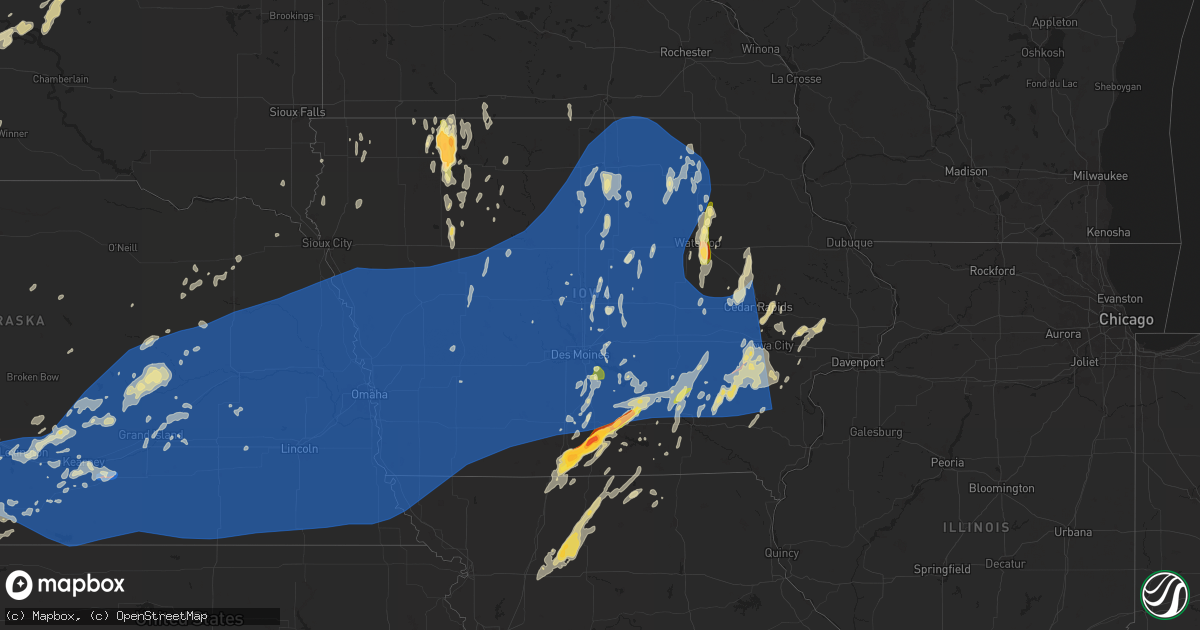
Hail Map in Iowa on May 23, 2024
Get this storm
May 23 map
$229
one time, instant access
Download today. No call, no setup
Keep the $229
Bought the map and want the full workflow? Apply the entire $229 to a subscription within 7 days. None of it is wasted.
Every map, not just this one
This buys you this map. Subscription and you get every map we run, in the markets you choose from a few cities to whole states to nationwide. Plus real-time alerts the moment a storm fires.
Contact data
Name, contact info, occupancy, even credit band for addresses in the footprint. You go from where it hit to who to call.
Become the source they trust
Unlimited branding weather history reports on demand. You already have the documented answer ready for the property owner, and you are the one who showed up with it.
Property data and RoofTrace estimates
Pull up any address you have got, its value and the exact code rules for that jurisdiction, straight from One Click Code. Then RoofTrace estimates the squares, pitch, and roof value, priced the way you price.
Storm reports in Iowa
Iowa
| Date | Description |
|---|---|
| 05/23/20246:45 AM CDT | Structural damage to homes and businesses. Possible tornado. |
| 05/23/20246:35 AM CDT | Structural damage to homes and businesses. Possible tornado. |
| 05/23/20246:35 AM CDT | Law enforcement reported tornado at wellman. |
| 05/23/20246:28 AM CDT | Reported tornado east of kinross. Stated to be 50 yards wide on the ground for roughly a mile to mile and a half. |
| 05/23/20246:20 AM CDT | A local report indicates 62 MPH wind near 3 E Charles City |
| 05/23/20246:18 AM CDT | Damage to shed at this location. Possible tornado. Time based on radar. |
| 05/23/20246:10 AM CDT | Delayed report from emergency management. Wind damage to trees and buildings. Time estimated from radar. |
| 05/23/20246:00 AM CDT | Structural damage. Estimated time. |
| 05/23/20246:00 AM CDT | Delayed report - estimated 70 mph winds and large branches down. Time estimated by radar. |
| 05/23/20245:59 AM CDT | Peak wind thus far at the kmcw asos. |
| 05/23/20245:56 AM CDT | Peak gust at oskaloosa airport. |
| 05/23/20245:51 AM CDT | Tree and utility damage near wellsburg. Time estimated from radar. |
| 05/23/20245:45 AM CDT | Social media report of tree partially down. |
| 05/23/20245:44 AM CDT | 1.25 hail. 1-2 feet diameter trees toppled on garages and homes. |
| 05/23/20245:38 AM CDT | Picture of large branches down in pella. |
| 05/23/20245:38 AM CDT | Large tree branches down. Power outages. Semi crashes due to wind along i-35. |
| 05/23/20245:37 AM CDT | Tree fell on garage in pella. Time estimated with radar. |
| 05/23/20245:35 AM CDT | Delayed report of large trees down and a silo destroyed south of pella. Time estimated by radar. |
| 05/23/20245:35 AM CDT | Peak wind gust at pella airport. |
| 05/23/20245:35 AM CDT | Delayed social media report of a large tree down near otley. Time estimated by radar. |
| 05/23/20245:30 AM CDT | Peak wind gust at iowa falls airport. |
| 05/23/20245:30 AM CDT | Peak wind at the newton airport. |
| 05/23/20245:30 AM CDT | Emergency manager reported overturned semis on highway 20. Time estimated from radar. |
| 05/23/20245:30 AM CDT | Storm chaser measured an 84 mph gust with a hand held anemometer. Also observed power flashes and trees down. Time estimated. |
| 05/23/20245:30 AM CDT | Delayed report of damage to a large farm building just east of belmond... With debris strewn into the field. Time estimated from radar. |
| 05/23/20245:26 AM CDT | Powerlines and trees down. Campers flipped. Time estimated with radar. |
| 05/23/20245:26 AM CDT | Picture of large tree down on house in pershing. Time estimated with radar. |
| 05/23/20245:22 AM CDT | Ping pong hail briefly fell followed by winds. Time estimated with radar. |
| 05/23/20245:22 AM CDT | Personal weather station. |
| 05/23/20245:20 AM CDT | Winds estimated 70 to 80 from sheriff deputy. |
| 05/23/20245:18 AM CDT | Quarter sized hail in readlyn. |
| 05/23/20245:15 AM CDT | Delayed report of semis tipped over on i35 near mile marker 139... Along with power line damage. Time estimated from radar. |
| 05/23/20245:15 AM CDT | Delayed social media report of a large tree down in pleasantville. Time estimated by radar. |
| 05/23/20245:13 AM CDT | A local report indicates 60 MPH wind near 1 W Webster City |
| 05/23/20245:08 AM CDT | Report from mping: 1-inch tree limbs broken; shingles blown off. |
| 05/23/20245:07 AM CDT | Large tree snapped on s duff on the south edge of town. Time and location estimated with radar. Relayed with social media. |
| 05/23/20245:04 AM CDT | Emergency manager reported power lines down. Highway 92 blocked with a large tree in the highway. Time and location estimated from radar. |
| 05/23/20245:04 AM CDT | Submitted photo of quarter sized hail near sandyville. |
| 05/23/20245:04 AM CDT | Personal weather station. |
| 05/23/20245:04 AM CDT | Several larger trees down in perry. 3500 without power in perry. |
| 05/23/20245:02 AM CDT | Mostly penny size hail with some the size of quarters. Time estimated by radar. |
| 05/23/20245:00 AM CDT | Spotter is estimating wind speeds around 60 mph. |
| 05/23/20245:00 AM CDT | Delayed social media report of a large tree down on the south side of ames. Time estimated by radar. |
| 05/23/20245:00 AM CDT | Social media report of tree uprooted. |
| 05/23/20244:57 AM CDT | 1 inch hail reported west of lovilia. Time and location estimated from radar. Relayed via broadcast media. |
| 05/23/20244:55 AM CDT | Nws damage survey identified damage consistent with an ef0 tornado that tracked from southern into eastern portions of johnston from 453 am to 457 am. |
| 05/23/20244:55 AM CDT | Delayed report of a tree down on a house. Time estimated from radar. |
| 05/23/20244:55 AM CDT | Delayed report. Social media picture of large tree branches down in johnston. Time estimated by radar. |
| 05/23/20244:55 AM CDT | Delayed social media report of leaning power poles east of humboldt on hwy 3. Time estimated by radar. |
| 05/23/20244:50 AM CDT | Delayed report of large tree down south of indianola. Time estimated from radar. |
| 05/23/20244:50 AM CDT | Report from mping: 3-inch tree limbs broken; power poles broken. |
| 05/23/20244:49 AM CDT | Submitted picture of half dollar sized hail in elk run heights. |
| 05/23/20244:49 AM CDT | Personal weather station recorded a wind gust of 69.5mph. |
| 05/23/20244:47 AM CDT | Large branch and power line down in street. |
| 05/23/20244:47 AM CDT | Corrects previous tstm wnd dmg report from madrid. Large branch and power line down in street. |
| 05/23/20244:44 AM CDT | Delayed - kest reported a peak gust of 51 kt. |
| 05/23/20244:40 AM CDT | Delayed social media picture of power poles down near boxholm. Time estimated by radar. |
| 05/23/20244:40 AM CDT | Reported by trained spotter. |
| 05/23/20244:37 AM CDT | Large tree down on a car in st. Charles. Time estimated from radar. |
| 05/23/20244:35 AM CDT | Trees down on the east side of winterset. Delayed report on social media. Time estimated from radar. |
| 05/23/20244:32 AM CDT | Peak wind at perry airport. |
| 05/23/20244:21 AM CDT | Delayed report of widespread tree damage. Time estimated from radar. |
| 05/23/20244:16 AM CDT | 70 to 75 mph gusts along with dime-sized hail. |
| 05/23/20244:15 AM CDT | Trees and power lines down. |
| 05/23/20244:15 AM CDT | Semi blown over and trees down near rockwell city. |
| 05/23/20244:14 AM CDT | Delayed report of a tree down on a house and damage to farm buildings. Time estimated from radar. |
| 05/23/20244:03 AM CDT | Delayed report of hail up to golf ball size from the derby fire department. Time estimated from radar. |
| 05/23/20244:00 AM CDT | Pws kiacarro39. |
| 05/23/20244:00 AM CDT | Estimated size of hail from social media. |
| 05/23/20243:58 AM CDT | Social media photo of tennis ball sized hail near humeston. Relayed via broadcast media. |
| 05/23/20243:53 AM CDT | Delayed report - media picture of 2 inch hail near humeston. |
| 05/23/20243:52 AM CDT | Delayed report - picture of at least baseball sized hail on the west side of humeston. |
| 05/23/20243:45 AM CDT | Pws kiagrisw2. |
| 05/23/20243:39 AM CDT | A local report indicates 62 MPH wind near Audubon |
| 05/23/20243:37 AM CDT | A local report indicates 67 MPH wind near Villisca |
| 05/23/20243:30 AM CDT | Emergency manager reported the city of elliot has lost power. |
| 05/23/20243:30 AM CDT | A local report indicates 1.00 inch wind near Nevada |
| 05/23/20243:26 AM CDT | A local report indicates 58 MPH wind near 2 W Elliott |
| 05/23/20243:23 AM CDT | Time estimated from radar. |
| 05/23/20243:21 AM CDT | A local report indicates 65 MPH wind near 2 SW Kirkman |
| 05/23/20243:20 AM CDT | Social media report between cambridge and nevada. |
| 05/23/20243:19 AM CDT | A local report indicates 69 MPH wind near 7 NE Emerson |
| 05/23/20243:15 AM CDT | A local report indicates 64 MPH wind near 2 E Harlan |
| 05/23/20243:14 AM CDT | Corrects previous hail report from 3 ese lakefield. Spotter reported a few quarter sized hail stones. |
| 05/23/20243:12 AM CDT | Personal weather station. |
| 05/23/20243:12 AM CDT | A local report indicates 60 MPH wind near 1 NW Harlan |
| 05/23/20243:10 AM CDT | Delayed report from emergency management of downed powerlines and limbs down on cars in henderson. Time estimated from radar. |
| 05/23/20243:10 AM CDT | A local report indicates 2.00 inch wind near 3 N Fostoria |
| 05/23/20243:07 AM CDT | Tree blown down with several other trees with broken branches. |
| 05/23/20243:07 AM CDT | Delayed cocorahs spotter report. Several large irregularly shaped hailstones. Time estimated via radar. |
| 05/23/20243:06 AM CDT | A local report indicates 62 MPH wind near 5 WNW Henderson |
| 05/23/20243:04 AM CDT | A local report indicates 67 MPH wind near 5 SE Treynor |
| 05/23/20242:57 AM CDT | Emergency management reported an overturned semi at the southbound rest area on i-29 in mills county. |
| 05/23/20242:52 AM CDT | A local report indicates 58 MPH wind near 5 WNW Persia |
| 05/23/20242:51 AM CDT | Law enforcement estimates 60 mph winds coming into the city of glenwood. |
| 05/23/20242:49 AM CDT | A local report indicates 1.75 inch wind near Spencer |
| 05/23/20242:49 AM CDT | Report from mping: 1-inch tree limbs broken; shingles blown off. |
| 05/23/20242:45 AM CDT | A local report indicates 74 MPH wind near 4 ENE Missouri Valley |
| 05/23/20242:41 AM CDT | 71 mph wind gust measured out of the missouri valley airport. |
| 05/23/20242:38 AM CDT | A local report indicates 73 MPH wind near Missouri Valley |
| 05/23/20242:05 AM CDT | Spotter submitted photo of quarter sized hail in rockwell city. Time estimated from radar. |
| 05/23/20241:40 AM CDT | Photo and report via social media. Time estimated from radar. |
All States Impacted by Hail Map on May 23, 2024
Cities Impacted by Hail Map on May 23, 2024
- Albany, KY
- Monticello, KY
- Alpha, KY
- Stoutland, MO
- Richland, MO
- Lebanon, MO
- Steelville, MO
- Mason, TX
- Glendale, KY
- Elizabethtown, KY
- Hodgenville, KY
- San Saba, TX
- Bonnieville, KY
- Ashdown, AR
- Wilton, AR
- Munfordville, KY
- Art, TX
- Castell, TX
- Llano, TX
- Pontotoc, TX
- Valley Spring, TX
- Canmer, KY
- Hardyville, KY
- Magnolia, KY
- New Haven, KY
- Ridgefield, CT
- North Salem, NY
- Eden, TX
- Loretto, KY
- New Hope, KY
- Brewster, NY
- Mertzon, TX
- Summersville, KY
- Greensburg, KY
- Danbury, CT
- Redding, CT
- Bethel, CT
- Sterling City, TX
- Melvin, TX
- Lebanon, KY
- Springfield, KY
- Easton, PA
- Stewartsville, NJ
- Campbellsville, KY
- Owensboro, KY
- Carlsbad, TX
- Buchanan Dam, TX
- Burnet, TX
- Kingsland, TX
- Brady, TX
- Asbury, NJ
- Adolphus, KY
- Scottsville, KY
- Westmoreland, TN
- Emmet, AR
- Rosston, AR
- Hope, AR
- Lohn, TX
- Rochelle, TX
- Marble Falls, TX
- Sag Harbor, NY
- Southampton, NY
- San Angelo, TX
- Pomona, NY
- Stony Point, NY
- Thiells, NY
- Bertram, TX
- Van Buren, MO
- East Hampton, NY
- Water Mill, NY
- Amawalk, NY
- Yorktown Heights, NY
- Katonah, NY
- Granite Springs, NY
- Croton Falls, NY
- Mahopac, NY
- Somers, NY
- Carmel, NY
- Bridgehampton, NY
- Sagaponack, NY
- Thornwood, NY
- Chappaqua, NY
- Pleasantville, NY
- Armonk, NY
- Putnam Valley, NY
- Cortlandt Manor, NY
- Mohegan Lake, NY
- Lake Peekskill, NY
- Tomkins Cove, NY
- Garnerville, NY
- West Haverstraw, NY
- Haverstraw, NY
- Croton On Hudson, NY
- Verplanck, NY
- Montrose, NY
- Buchanan, NY
- Peekskill, NY
- Liberty Hill, TX
- New City, NY
- Congers, NY
- Suffern, NY
- Richland Springs, TX
- Briarcliff Manor, NY
- Elmsford, NY
- White Plains, NY
- Millersview, TX
- North Kingstown, RI
- Jamestown, RI
- Saunderstown, RI
- Greenville, MO
- Lometa, TX
- Gouldbusk, TX
- Voss, TX
- Coleman, TX
- Marquand, MO
- Lampasas, TX
- Jewett City, CT
- Plainfield, CT
- Voluntown, CT
- Snow Lake, AR
- Baltic, CT
- Canterbury, CT
- Norwich, CT
- Shelter Island, NY
- Patton, MO
- Fredericktown, MO
- Saint Mary, MO
- Sainte Genevieve, MO
- Moosup, CT
- Perryville, MO
- South Salem, NY
- Kempner, TX
- Shrub Oak, NY
- Purdys, NY
- Goldthwaite, TX
- Shelter Island Heights, NY
- Copperas Cove, TX
- Star, TX
- Evant, TX
- Sparta, IL
- Chester, IL
- Steeleville, IL
- Rockwood, TX
- Percy, IL
- Cutler, IL
- Greenville, MS
- Belton, TX
- Temple, TX
- Moody, TX
- Gatesville, TX
- Campbell Hill, IL
- Troy, TX
- Lott, TX
- Eddy, TX
- Coulterville, IL
- Santa Anna, TX
- Oakdale, IL
- Pinckneyville, IL
- Purmela, TX
- Berlin, NH
- Milan, NH
- Benton, IL
- Christopher, IL
- Mulkeytown, IL
- Wilton, ME
- Anson, ME
- Nashville, IL
- Brookesmith, TX
- New Portland, ME
- Farmington, ME
- New Vineyard, ME
- North Anson, ME
- West Paris, ME
- Sesser, IL
- Madison, ME
- Sumner, ME
- Greenville, ME
- Claremont, SD
- Groton, SD
- Madisonville, KY
- Dawson Springs, KY
- Earlington, KY
- Sharon Grove, KY
- Oglesby, TX
- Lewisburg, KY
- Brownville, ME
- McGregor, TX
- Russellville, KY
- Portage, ME
- Huntsville, AL
- Gurley, AL
- Brooks, ME
- Augusta, ME
- Lorena, TX
- Auburn, KY
- Morgantown, KY
- Bruceville, TX
- Jonesboro, TX
- Clifton, TX
- Washburn, ME
- Waco, TX
- Hampden, ME
- Carmel, ME
- New Market, AL
- Hewitt, TX
- Chilton, TX
- Bridgewater, ME
- Rumsey, KY
- Sacramento, KY
- Celina, TN
- Byrdstown, TN
- Burkesville, KY
- Mapleton, ME
- Riesel, TX
- Westfield, ME
- Presque Isle, ME
- Sherman, ME
- Benedicta, ME
- Stacyville, ME
- Cranfills Gap, TX
- Meridian, TX
- Franklin, KY
- Whitney, TX
- Abbott, TX
- Houlton, ME
- Calhoun, GA
- Sugar Valley, GA
- Aquilla, TX
- Alvaton, KY
- Plainville, GA
- Armuchee, GA
- Resaca, GA
- Morgan, TX
- Austin, KY
- Fountain Run, KY
- Penelope, TX
- West, TX
- Hillsboro, TX
- Orient, ME
- Strasburg, VA
- Toms Brook, VA
- Buckfield, ME
- Forbes, ND
- Jay, ME
- Leola, SD
- Carthage, TN
- Blum, TX
- Kopperl, TX
- Covington, TX
- Lisco, NE
- Presho, SD
- Hestand, KY
- Faulkton, SD
- Fort Thompson, SD
- Newcastle, OK
- Highmore, SD
- Malone, TX
- Bynum, TX
- Ellendale, ND
- Tompkinsville, KY
- Mustang, OK
- Yukon, OK
- Oklahoma City, OK
- Bethany, OK
- Fullerton, ND
- Oshkosh, NE
- Itasca, TX
- Frost, TX
- Mertens, TX
- Rotan, TX
- Stephan, SD
- Moss, TN
- Orient, SD
- Seneca, SD
- Arthur, NE
- Ashby, NE
- Frederick, SD
- Allons, TN
- Milford, TX
- Lamoure, ND
- Italy, TX
- Robert Lee, TX
- Cresbard, SD
- Wellington, TX
- Childress, TX
- Lodgepole, NE
- Dodson, TX
- Grandview, TX
- Edmond, OK
- Lewellen, NE
- Goodfellow Afb, TX
- Wood, SD
- Bronte, TX
- Strasburg, ND
- White River, SD
- Mission, SD
- Hamlin, TX
- Lower Brule, SD
- Ipswich, SD
- Spencer, OK
- Aspermont, TX
- Fort Yates, ND
- Maypearl, TX
- Erick, OK
- Texola, OK
- Linton, ND
- Jones, OK
- Oakes, ND
- Aberdeen, SD
- Old Glory, TX
- Mansfield, SD
- Harrold, SD
- Ree Heights, SD
- Miller, SD
- Blooming Grove, TX
- Catawba, NC
- Waxahachie, TX
- Paducah, TX
- Hollis, OK
- Bingham, NE
- Vancourt, TX
- Wall, TX
- Point Of Rocks, MD
- Adamstown, MD
- Tuscarora, MD
- Jefferson, MD
- Big Springs, NE
- Chappell, NE
- Cogswell, ND
- Saint Francis, SD
- Leesburg, VA
- Lovettsville, VA
- Corsicana, TX
- Barry, TX
- Waterford, VA
- Hague, ND
- Sherrills Ford, NC
- Draper, SD
- Rice, TX
- Seymour, TX
- Gould, OK
- Forman, ND
- McCaulley, TX
- Hamilton, VA
- Purcellville, VA
- Kintyre, ND
- Roscoe, SD
- Marlin, TX
- Ashburn, VA
- Powell, TX
- Dickerson, MD
- Roby, TX
- Frederick, MD
- Ijamsville, MD
- Merriman, NE
- Napoleon, ND
- Wishek, ND
- Cheyenne, OK
- Sterling, VA
- Cody, NE
- Kerens, TX
- Winner, SD
- Anson, TX
- Stamford, TX
- Valentine, NE
- Reeder, ND
- Holabird, SD
- Fredonia, ND
- Menard, TX
- Herndon, VA
- Brule, NE
- Duke, OK
- Hettinger, ND
- Kosse, TX
- Athens, TX
- Malakoff, TX
- Saint Lawrence, SD
- Sayre, OK
- Mangum, OK
- Vinson, OK
- Willow, OK
- Trinidad, TX
- Eldorado, OK
- Witten, SD
- Reston, VA
- Reagan, TX
- Lemoyne, NE
- Bethlehem, PA
- Wessington, SD
- Streeter, ND
- Gackle, ND
- Kulm, ND
- Concord, NC
- Rockwell, NC
- Kannapolis, NC
- Larue, TX
- Athens, TN
- Zeeland, ND
- Ogallala, NE
- Thornton, TX
- Groesbeck, TX
- Crookston, NE
- Keystone, NE
- Grant, NE
- Venango, NE
- Frankston, TX
- Chandler, TX
- Flint, TX
- Bullard, TX
- Tulare, SD
- Hitchcock, SD
- Rockham, SD
- Redfield, SD
- Ashton, SD
- Lehr, ND
- Ashley, ND
- Dupree, SD
- Franklin, TX
- Altus, OK
- Olustee, OK
- Reisterstown, MD
- Owings Mills, MD
- Onaka, SD
- Jud, ND
- Montpelier, ND
- Fort Pierre, SD
- Pierre, SD
- Madrid, NE
- Paxton, NE
- Troup, TX
- Whitehouse, TX
- Tyler, TX
- Onida, SD
- Keldron, SD
- Lemmon, SD
- Elsie, NE
- Hext, TX
- Crossville, TN
- Crab Orchard, TN
- Rockwood, TN
- Sutherland, NE
- Morristown, SD
- Agar, SD
- Middletown, VA
- Stephens City, VA
- Front Royal, VA
- Woodstock, VA
- El Dorado, KS
- Augusta, KS
- Leon, KS
- Frankfort, SD
- Mott, ND
- New Leipzig, ND
- Gettysburg, SD
- Wallace, NE
- Imperial, NE
- Wauneta, NE
- Hickory, NC
- Cassoday, KS
- Spring Grove, PA
- Seven Valleys, PA
- Marquez, TX
- Enders, NE
- Hayes Center, NE
- Altus Afb, OK
- Marble, NC
- Jewett, TX
- Red Lion, PA
- Dallastown, PA
- York, PA
- Elmer, OK
- Glen Rock, PA
- Burns, KS
- Andrews, NC
- Murphy, NC
- Herreid, SD
- Headrick, OK
- Hoven, SD
- Selby, SD
- Blair, OK
- Emporia, KS
- Cottonwood Falls, KS
- Hershey, NE
- Tellico Plains, TN
- Warne, NC
- Brasstown, NC
- Benkelman, NE
- Palisade, NE
- Dickens, NE
- Hayesville, NC
- Stratton, NE
- Java, SD
- Mound City, SD
- Robbinsville, NC
- Americus, KS
- North Platte, NE
- Maxwell, NE
- Trenton, NE
- Culbertson, NE
- Bassett, NE
- Snyder, OK
- Mountain Park, OK
- Tipton, OK
- Max, NE
- Mount Pleasant, NC
- Wellfleet, NE
- Maywood, NE
- McCook, NE
- Roosevelt, OK
- Indianola, NE
- Burwell, NE
- Valley View, TX
- Lawton, OK
- Frederick, OK
- Sanger, TX
- Hendrix, OK
- Durant, OK
- Calera, OK
- Era, TX
- Gainesville, TX
- Curtis, NE
- Oberlin, KS
- Indiahoma, OK
- Forestburg, TX
- Saint Jo, TX
- Bartley, NE
- Muenster, TX
- Danbury, NE
- Stockville, NE
- Collinsville, TX
- Tioga, TX
- Bokchito, OK
- Pilot Point, TX
- Wylie, TX
- Allen, TX
- Cambridge, NE
- Whitesboro, TX
- Caddo, OK
- Lindsay, TX
- Princeton, TX
- Comstock, NE
- Cozad, NE
- Elgin, OK
- Moorefield, NE
- Lebanon, NE
- Howe, TX
- Eustis, NE
- Glen Ullin, ND
- Elgin, ND
- Sherman, TX
- Pottsboro, TX
- Gunter, TX
- Farmersville, TX
- Wilsonville, NE
- Cyril, OK
- Fletcher, OK
- Apache, OK
- Cache, OK
- Atwood, KS
- Herndon, KS
- Mead, OK
- Cartwright, OK
- Denison, TX
- Colbert, OK
- Holbrook, NE
- Thackerville, OK
- Sadler, TX
- Arapahoe, NE
- Eddyville, NE
- Cement, OK
- Lexington, NE
- Norcatur, KS
- Hendley, NE
- Fort Sill, OK
- Greenville, TX
- Celeste, TX
- Oconto, NE
- Sumner, NE
- Mason City, NE
- Bennington, OK
- Boswell, OK
- Edison, NE
- Beaver City, NE
- Ninnekah, OK
- Rush Springs, OK
- Elwood, NE
- Bartlett, NE
- Madill, OK
- Wolfe City, TX
- Oxford, NE
- Elm Creek, NE
- Miller, NE
- Amherst, NE
- Overton, NE
- Neligh, NE
- Litchfield, NE
- Marlow, OK
- Gordonville, TX
- Bells, TX
- Farnam, NE
- Smithfield, NE
- Loomis, NE
- Bertrand, NE
- Holdrege, NE
- Kearney, NE
- Funk, NE
- Orleans, NE
- Atlanta, NE
- Stamford, NE
- Whitewright, TX
- Plainview, NE
- Lindsay, OK
- Foster, OK
- Loup City, NE
- Ravenna, NE
- Commerce, TX
- Spalding, NE
- Greeley, NE
- Soper, OK
- Hugo, OK
- Duncan, OK
- Savoy, TX
- Ector, TX
- Bonham, TX
- Pleasanton, NE
- Hazard, NE
- Elba, NE
- Saint Paul, NE
- Klondike, TX
- Scotia, NE
- Almena, KS
- Rockville, NE
- Ashton, NE
- Dannebrog, NE
- Oakdale, NE
- Farwell, NE
- Wolbach, NE
- Tilden, NE
- Alma, NE
- Republican City, NE
- Phillipsburg, KS
- Axtell, NE
- Wilcox, NE
- Hildreth, NE
- Franklin, NE
- Riverton, NE
- Bloomington, NE
- Naponee, NE
- Agra, KS
- Riverdale, NE
- Upland, NE
- Minden, NE
- Odessa, NE
- Gibbon, NE
- Heartwell, NE
- Atoka, OK
- Boelus, NE
- Albion, NE
- Van Alstyne, TX
- Trenton, TX
- Osmond, NE
- Logan, KS
- Cairo, NE
- Hill City, KS
- Primrose, NE
- Prairie View, KS
- Lane, OK
- Elmore City, OK
- Tussy, OK
- Ratliff City, OK
- Hennepin, OK
- Randolph, TX
- Leonard, TX
- Inavale, NE
- Kenesaw, NE
- Campbell, NE
- Shelton, NE
- Red Cloud, NE
- Bladen, NE
- Holstein, NE
- Wood River, NE
- Ayr, NE
- Juniata, NE
- Blue Hill, NE
- Doniphan, NE
- Hastings, NE
- Roseland, NE
- Stockton, KS
- Bogue, KS
- Palmer, NE
- Alda, NE
- Cedar Rapids, NE
- Fullerton, NE
- Saint Libory, NE
- Belgrade, NE
- Trumbull, NE
- Grand Island, NE
- Phillips, NE
- Chapman, NE
- Pierce, NE
- Hamilton, MO
- Kidder, MO
- Cameron, MO
- North Loup, NE
- Palco, KS
- Springer, OK
- Wynnewood, OK
- Davis, OK
- Aurora, NE
- Marquette, NE
- Clay Center, NE
- Saint Edward, NE
- Giltner, NE
- Inland, NE
- Deweese, NE
- Harvard, NE
- Archer, NE
- Central City, NE
- Guide Rock, NE
- Lawrence, NE
- Glenvil, NE
- Fairfield, NE
- Lindsay, NE
- Newman Grove, NE
- Clarks, NE
- Nelson, NE
- Genoa, NE
- Hordville, NE
- Silver Creek, NE
- Glade, KS
- Ellis, KS
- Ogallah, KS
- Damar, KS
- Randolph, NE
- Gallatin, MO
- Breckenridge, MO
- Saronville, NE
- Polk, NE
- Hampton, NE
- Ong, NE
- Oak, NE
- Edgar, NE
- Superior, NE
- Sutton, NE
- Henderson, NE
- Columbus, NE
- Madison, NE
- Norfolk, NE
- Bradshaw, NE
- Stromsburg, NE
- Monroe, NE
- Platte Center, NE
- Osceola, NE
- Benedict, NE
- Humphrey, NE
- Ardmore, OK
- Roff, OK
- Sulphur, OK
- Dougherty, OK
- Shickley, NE
- Strang, NE
- Byron, NE
- Hebron, NE
- McCool Junction, NE
- Fairmont, NE
- Ruskin, NE
- Geneva, NE
- Davenport, NE
- Deshler, NE
- Grafton, NE
- Carleton, NE
- York, NE
- Hardy, NE
- Shelby, NE
- Waco, NE
- Bruning, NE
- Creston, NE
- Duncan, NE
- Stanton, NE
- Gresham, NE
- Lock Springs, MO
- Jamesport, MO
- Brady, NE
- Honey Grove, TX
- Sumner, TX
- Chillicothe, MO
- Beresford, SD
- Centerville, SD
- Ainsworth, NE
- Gothenburg, NE
- Cumby, TX
- Campbell, TX
- Mill Creek, OK
- Stonewall, OK
- Mannsville, OK
- Tishomingo, OK
- Belvidere, NE
- Ohiowa, NE
- Rising City, NE
- David City, NE
- Surprise, NE
- Pilger, NE
- Leigh, NE
- Beaver Crossing, NE
- Milligan, NE
- Wisner, NE
- Schuyler, NE
- Howells, NE
- Clarkson, NE
- Bellwood, NE
- Exeter, NE
- Utica, NE
- Staplehurst, NE
- Ulysses, NE
- Hudson, SD
- Rock Valley, IA
- Bagwell, TX
- Boyden, IA
- Sac City, IA
- Anna, TX
- Trenton, MO
- Newcastle, NE
- Dixon, NE
- Nemaha, IA
- Newell, IA
- Storm Lake, IA
- Everly, IA
- Daykin, NE
- Cordova, NE
- Western, NE
- Dodge, NE
- Seward, NE
- Friend, NE
- Milford, NE
- Bee, NE
- Tobias, NE
- Dorchester, NE
- Brainard, NE
- Linwood, NE
- Alexandria, NE
- Gilead, NE
- Dwight, NE
- Fairbury, NE
- Goehner, NE
- Bruno, NE
- Prague, NE
- Beemer, NE
- Scribner, NE
- Morse Bluff, NE
- Snyder, NE
- Bancroft, NE
- Wilber, NE
- North Bend, NE
- Garland, NE
- Abie, NE
- Crete, NE
- Rogers, NE
- West Point, NE
- Pender, NE
- Sulphur Springs, TX
- Milburn, OK
- Coleman, OK
- Wapanucka, OK
- Newtown, MO
- Milford, IA
- Lebanon, SD
- Clarksville, TX
- Eureka, SD
- Chester, NE
- Hubbell, NE
- Swanton, NE
- Pleasant Dale, NE
- Weston, NE
- Plymouth, NE
- Valparaiso, NE
- Roca, NE
- Davey, NE
- De Witt, NE
- Denton, NE
- Cortland, NE
- Raymond, NE
- Pickrell, NE
- Hallam, NE
- Ceresco, NE
- Jansen, NE
- Martell, NE
- Wahoo, NE
- Lincoln, NE
- Clatonia, NE
- Sprague, NE
- Malcolm, NE
- Beatrice, NE
- Malmo, NE
- Cedar Bluffs, NE
- Firth, NE
- Valley, NE
- Colon, NE
- Waverly, NE
- Hickman, NE
- Oakland, NE
- Hooper, NE
- Ames, NE
- Yutan, NE
- Fremont, NE
- Mead, NE
- Winslow, NE
- Ithaca, NE
- Ashland, NE
- Nickerson, NE
- Rosalie, NE
- Lyons, NE
- Herman, NE
- Uehling, NE
- Craig, NE
- Arlington, NE
- Lake City, IA
- Spirit Lake, IA
- George, IA
- Kenefic, OK
- Lake Park, IA
- Spickard, MO
- Albert City, IA
- Marathon, IA
- Rembrandt, IA
- Akron, IA
- Pollock, MO
- Lucerne, MO
- Unionville, MO
- Rock Rapids, IA
- Doon, IA
- Eagle, NE
- Greenwood, NE
- Adams, NE
- Panama, NE
- Walton, NE
- Filley, NE
- Alvo, NE
- Bennet, NE
- Memphis, NE
- Palmyra, NE
- Elmwood, NE
- Cedar Creek, NE
- Springfield, NE
- Louisville, NE
- Gretna, NE
- Sterling, NE
- Tecumseh, NE
- Papillion, NE
- Omaha, NE
- La Vista, NE
- Murdock, NE
- Weeping Water, NE
- South Bend, NE
- Waterloo, NE
- Elkhorn, NE
- Unadilla, NE
- Avoca, NE
- Douglas, NE
- Fort Calhoun, NE
- Kennard, NE
- Blair, NE
- Decatur, NE
- Washington, NE
- Missouri Valley, IA
- Bennington, NE
- Boys Town, NE
- Modale, IA
- Tekamah, NE
- Mondamin, IA
- Onawa, IA
- Winnebago, NE
- Macy, NE
- Walthill, NE
- Little Sioux, IA
- Whiting, IA
- Blencoe, IA
- Sloan, IA
- Rockwell City, IA
- Jackson, MN
- Princeton, MO
- Galt, MO
- Ceylon, MN
- Dolliver, IA
- Fairmont, MN
- Harris, MO
- Sioux Rapids, IA
- Eagleville, MO
- Green Castle, MO
- Novinger, MO
- Caney, OK
- Burr, NE
- Manley, NE
- Otoe, NE
- Syracuse, NE
- Elk Creek, NE
- Crab Orchard, NE
- Cook, NE
- Pisgah, IA
- Hornick, IA
- Nebraska City, NE
- Union, NE
- Crescent, IA
- Offutt Afb, NE
- Council Bluffs, IA
- Nehawka, NE
- Pacific Junction, IA
- Talmage, NE
- Plattsmouth, NE
- Carter Lake, IA
- Lorton, NE
- Murray, NE
- Bellevue, NE
- Dunbar, NE
- Blythedale, MO
- Glidden, IA
- Ridgeway, MO
- Carroll, IA
- Sherburn, MN
- Welcome, MN
- Greenville, IA
- Webb, IA
- Windom, MN
- Bingham Lake, MN
- Bonnerdale, AR
- Cincinnati, IA
- Centerville, IA
- Brock, NE
- Steinauer, NE
- Pawnee City, NE
- Odell, NE
- Liberty, NE
- Virginia, NE
- Blue Springs, NE
- Lewiston, NE
- Diller, NE
- Burchard, NE
- Reynolds, NE
- Thurman, IA
- Tabor, IA
- Hastings, IA
- Malvern, IA
- Mineola, IA
- Percival, IA
- Johnson, NE
- Sidney, IA
- Silver City, IA
- Glenwood, IA
- Underwood, IA
- Neola, IA
- Minden, IA
- Castana, IA
- Woodbine, IA
- Macedonia, IA
- Treynor, IA
- Magnolia, IA
- Moorhead, IA
- McClelland, IA
- Honey Creek, IA
- Logan, IA
- Henderson, IA
- Rodney, IA
- Oto, IA
- Dunlap, IA
- Mapleton, IA
- Ute, IA
- Persia, IA
- Soldier, IA
- Smithland, IA
- Le Mars, IA
- Hull, IA
- Davis City, IA
- Spencer, IA
- Decatur, IA
- Lamoni, IA
- Leon, IA
- Rolfe, IA
- West Bend, IA
- Reading, MN
- Brewster, MN
- Worthington, MN
- Moulton, IA
- Mountain Lake, MN
- Julian, NE
- Rock Port, MO
- Randolph, IA
- Hamburg, IA
- Peru, NE
- Table Rock, NE
- Auburn, NE
- Humboldt, NE
- Shenandoah, IA
- Essex, IA
- Watson, MO
- Imogene, IA
- Brownville, NE
- Carson, IA
- Riverton, IA
- Farragut, IA
- Emerson, IA
- Red Oak, IA
- Portsmouth, IA
- Harlan, IA
- Panama, IA
- Oakland, IA
- Walnut, IA
- Elliott, IA
- Shelby, IA
- Hancock, IA
- Avoca, IA
- Griswold, IA
- Drakesville, IA
- Hampton, IA
- Aredale, IA
- Sheffield, IA
- Newton, IA
- Baxter, IA
- Udell, IA
- Unionville, IA
- Antlers, OK
- Fostoria, IA
- Palmer, IA
- Pocahontas, IA
- Moravia, IA
- Powersville, MO
- Oyens, IA
- Remsen, IA
- Blakesburg, IA
- Danbury, IA
- Westphalia, IA
- Earling, IA
- Defiance, IA
- Battle Creek, IA
- Kirkman, IA
- Manilla, IA
- Arion, IA
- Charter Oak, IA
- Denison, IA
- Schleswig, IA
- Ricketts, IA
- Dow City, IA
- Harris, IA
- Fort Towson, OK
- Spencerville, OK
- Sawyer, OK
- Glenwood, AR
- Allerton, IA
- Corydon, IA
- Dougherty, IA
- Garvin, OK
- Arnolds Park, IA
- Okoboji, IA
- Dickens, IA
- New Boston, TX
- De Kalb, TX
- Ottumwa, IA
- Rhodes, IA
- Cambridge, IA
- Conrad, IA
- Foreman, AR
- Telephone, TX
- Arthur City, TX
- Eldora, IA
- Belle Plaine, IA
- Terril, IA
- Gillett Grove, IA
- Garden Grove, IA
- Lonoke, AR
- Humeston, IA
- Fairfax, MO
- Nemaha, NE
- Stella, NE
- Shubert, NE
- Tarkio, MO
- Northboro, IA
- Westboro, MO
- Coin, IA
- Clarinda, IA
- Blanchard, IA
- Grant, IA
- Carbon, IA
- Nodaway, IA
- Villisca, IA
- Yorktown, IA
- Corning, IA
- Stanton, IA
- Cumberland, IA
- Marne, IA
- Lewis, IA
- Brayton, IA
- Wiota, IA
- Irwin, IA
- Bridgewater, IA
- Audubon, IA
- Exira, IA
- Manning, IA
- Anita, IA
- Massena, IA
- Kimballton, IA
- Elk Horn, IA
- Atlantic, IA
- Templeton, IA
- Aspinwall, IA
- Gray, IA
- Hamlin, IA
- Westside, IA
- Vail, IA
- Nevada, IA
- Elberon, IA
- Ruthven, IA
- Ayrshire, IA
- State Center, IA
- Melbourne, IA
- Curlew, IA
- Eddyville, IA
- Saint Anthony, IA
- Woodburn, IA
- Colo, IA
- Elmo, MO
- College Springs, IA
- New Market, IA
- Adair, IA
- Creston, IA
- Greenfield, IA
- Fontanelle, IA
- Orient, IA
- Prescott, IA
- Chariton, IA
- Derby, IA
- Ollie, IA
- Richland, IA
- Batavia, IA
- Hedrick, IA
- Sigourney, IA
- Packwood, IA
- Lineville, IA
- New Virginia, IA
- McCallsburg, IA
- Allison, IA
- Clarksville, IA
- Clutier, IA
- Keystone, IA
- Dysart, IA
- Zearing, IA
- Scarville, IA
- Kiester, MN
- Amity, AR
- Lakefield, MN
- Cainsville, MO
- Lucas, IA
- Lenox, IA
- Sharpsburg, IA
- Gravity, IA
- Cromwell, IA
- Bedford, IA
- Shambaugh, IA
- Braddyville, IA
- Stuart, IA
- Guthrie Center, IA
- Menlo, IA
- Coon Rapids, IA
- Casey, IA
- Deloit, IA
- Halbur, IA
- Scranton, IA
- Bagley, IA
- Ida Grove, IA
- Kiron, IA
- Breda, IA
- Ralston, IA
- Dedham, IA
- Panora, IA
- Lidderdale, IA
- Arcadia, IA
- Bayard, IA
- Royal, IA
- Mercer, MO
- Keota, IA
- Bricelyn, MN
- Holland, IA
- Greene, IA
- Marshalltown, IA
- Grundy Center, IA
- Estherville, IA
- Harper, IA
- Wellsburg, IA
- Russell, IA
- Lorimor, IA
- Afton, IA
- Thayer, IA
- Dexter, IA
- Macksburg, IA
- Winterset, IA
- Murray, IA
- Peru, IA
- Rippey, IA
- Adel, IA
- Perry, IA
- Redfield, IA
- Minburn, IA
- Dawson, IA
- Linden, IA
- Earlham, IA
- Jefferson, IA
- Churdan, IA
- Grand Junction, IA
- Yale, IA
- Jamaica, IA
- Weldon, IA
- Nashua, IA
- Charles City, IA
- Wellman, IA
- Albion, IA
- Parkersburg, IA
- Havelock, IA
- Washington, IA
- Blossom, TX
- Paris, TX
- Pattonville, TX
- Lockridge, IA
- Mount Pleasant, IA
- Osceola, IA
- Alden, IA
- Winnebago, MN
- Delavan, MN
- Indianola, IA
- La Porte City, IA
- Laurens, IA
- Wayland, IA
- Truro, IA
- Van Meter, IA
- Dallas Center, IA
- Prole, IA
- De Soto, IA
- Saint Charles, IA
- Patterson, IA
- Waukee, IA
- Bouton, IA
- Ogden, IA
- Beaver, IA
- Booneville, IA
- Woodward, IA
- Waterloo, IA
- Jesup, IA
- Gilbertville, IA
- Evansdale, IA
- Raymond, IA
- Lovilia, IA
- Melrose, IA
- Ainsworth, IA
- Deport, TX
- Bogata, TX
- Detroit, TX
- Riverside, IA
- Mallard, IA
- Moorland, IA
- Somers, IA
- Alden, MN
- Wells, MN
- Milo, IA
- Oxford, IA
- Williamsburg, IA
- Kalona, IA
- North Liberty, IA
- Parnell, IA
- Amboy, MN
- Cumming, IA
- Ellston, IA
- Diagonal, IA
- Norwalk, IA
- Shannon City, IA
- Tingley, IA
- Clearfield, IA
- Lacona, IA
- Bevington, IA
- Johnston, IA
- Saint Marys, IA
- Granger, IA
- Carlisle, IA
- Liberty Center, IA
- Windsor Heights, IA
- Urbandale, IA
- Madrid, IA
- Grimes, IA
- Clive, IA
- Des Moines, IA
- Martensdale, IA
- Pleasantville, IA
- West Des Moines, IA
- Ackworth, IA
- Ankeny, IA
- Berwick, IA
- Boone, IA
- Polk City, IA
- Hartford, IA
- Runnells, IA
- Swan, IA
- Altoona, IA
- Pleasant Hill, IA
- Elkhart, IA
- Mitchellville, IA
- Alleman, IA
- Slater, IA
- Luther, IA
- Prairie City, IA
- Bondurant, IA
- Huxley, IA
- Ames, IA
- Kelley, IA
- Sheldahl, IA
- Cedar Rapids, IA
- Ely, IA
- Solon, IA
- Swisher, IA
- Columbus Junction, IA
- Iowa Falls, IA
- Emmetsburg, IA
- Conesville, IA
- Plainfield, IA
- Ionia, IA
- Iowa City, IA
- Coralville, IA
- Whittemore, IA
- Cylinder, IA
- Grand River, IA
- Melcher Dallas, IA
- Columbia, IA
- Knoxville, IA
- Otley, IA
- Colfax, IA
- Monroe, IA
- Ira, IA
- Maxwell, IA
- Mingo, IA
- Collins, IA
- Roland, IA
- New Hampton, IA
- West Branch, IA
- Fremont, IA
- Kirkville, IA
- Cedar, IA
- Chillicothe, IA
- Mount Vernon, IA
- Marion, IA
- Hamilton, IA
- West Liberty, IA
- Fenton, IA
- Bussey, IA
- Talco, TX
- Mount Pleasant, TX
- Oskaloosa, IA
- Dunkerton, IA
- University Park, IA
- Albia, IA
- Readlyn, IA
- Denver, IA
- Rose Hill, IA
- Tipton, IA
- Springville, IA
- Atalissa, IA
- Belmond, IA
- Central City, IA
- Tracy, IA
- Mechanicsville, IA
- Lisbon, IA
- Laurel, IA
- Clemons, IA
- Reasnor, IA
- Union, IA
- Haverhill, IA
- Killduff, IA
- Pella, IA
- Gilman, IA
- Lynnville, IA
- Sully, IA
- Grinnell, IA
- Kellogg, IA
- Ferguson, IA
- Harvey, IA
- New Providence, IA
- Williams, IA
- Bradford, IA
- Hubbard, IA
- Ellsworth, IA
- Radcliffe, IA
- Story City, IA
- Garden City, IA
- Jewell, IA
- Stratford, IA
- Gilbert, IA
- Kamrar, IA
- Paton, IA
- Pilot Mound, IA
- Randall, IA
- Blairsburg, IA
- Stanhope, IA
- Dana, IA
- Boxholm, IA
- Steamboat Rock, IA
- Whitten, IA
- Ackley, IA
- Geneva, IA
- Leighton, IA
- Liscomb, IA
- Williamson, IA
- Beacon, IA
- New Sharon, IA
- Searsboro, IA
- Montezuma, IA
- Aplington, IA
- Traer, IA
- Toledo, IA
- Barnes City, IA
- Beaman, IA
- Lincoln, IA
- Malcom, IA
- Garwin, IA
- Montour, IA
- Austinville, IA
- Le Grand, IA
- Gladbrook, IA
- Tama, IA
- Brooklyn, IA
- What Cheer, IA
- Chelsea, IA
- Sumner, IA
- Tripoli, IA
- Fairbank, IA
- Dewar, IA
- Lowden, IA
- Bennett, IA
- Clarence, IA
- Coldwater, MS
- Clarion, IA
- Rowan, IA
- Goodell, IA
- Rockwell, IA
- Swaledale, IA
- Fonda, IA
- Klemme, IA
- Hudson, IA
- Millerton, IA
- Thornton, IA
- Latimer, IA
- Delta, IA
- Keswick, IA
- Deep River, IA
- Gibson, IA
- Reinbeck, IA
- Dumont, IA
- Potts Camp, MS
- Millington, TN
- Clear Lake, IA
- Waverly, IA
- Maurertown, VA
- Chapin, IA
- Ventura, IA
- Garner, IA
- Paeonian Springs, VA
- Promise City, IA
- Northwood, IA
- Mason City, IA
- Hanlontown, IA
- Kesley, IA
- Manly, IA
- Kensett, IA
- Rockford, IA
- Bristow, IA
- Marble Rock, IA
- Nora Springs, IA
- Coulter, IA
- Harcourt, IA
- Alexander, IA
- Burnside, IA
- Dayton, IA
- Webster City, IA
- Fort Dodge, IA
- Duncombe, IA
- Lehigh, IA
- Dows, IA
- Meservey, IA
- Otho, IA
- Popejoy, IA
- Woolstock, IA
- Hardy, IA
- Lohrville, IA
- Thor, IA
- Vincent, IA
- Callender, IA
- Goldfield, IA
- Eagle Grove, IA
- Kanawha, IA
- Fertile, IA
- Galt, IA
- Farnhamville, IA
- Gowrie, IA
- Badger, IA
- Lake View, IA
- Arthur, IA
- Lytton, IA
- Odebolt, IA
- Knierim, IA
- Lanesboro, IA
- Manson, IA
- Barnum, IA
- Auburn, IA
- Wall Lake, IA
- Clare, IA
- Renwick, IA
- Forest City, IA
- Joice, IA
- Humboldt, IA
- Britt, IA
- Cordova, TN
- Memphis, TN
- Drummonds, TN
- Hickory Flat, MS
- Rison, AR
- Webster, IA
- Plymouth, IA
- Osage, IA
- Glenville, MN
- Rock Falls, IA
- Rudd, IA
- Lyle, MN
- Saint Ansgar, IA
- Carpenter, IA
- Grafton, IA
- Floyd, IA
- Orchard, IA
- New Hartford, IA
- Janesville, IA
- Dike, IA
- Stout, IA
- Morrison, IA
- Shell Rock, IA
- Cedar Falls, IA
- Guernsey, IA
- Ladora, IA
- Blairstown, IA
- Hartwick, IA
- Hayesville, IA
- Vining, IA
- Martinsburg, IA
- North English, IA
- Van Horne, IA
- Victor, IA
- Luzerne, IA
- Marengo, IA
- Millersburg, IA
- South English, IA
- Fairfield, IA
- Elma, IA
- Colwell, IA
- Stacyville, IA
- Alta Vista, IA
- Riceville, IA
- Little Cedar, IA
- Frederika, IA
- Arlington, TN
- Blue Mountain, MS
- Byhalia, MS
- Olive Branch, MS
- Ashland, MS
- Ripley, MS
- Conroy, IA
- Brighton, IA
- West Chester, IA
- Watkins, IA
- South Amana, IA
- Middle Amana, IA
- Newhall, IA
- Homestead, IA
- Amana, IA
- Norway, IA
- Fredericksburg, IA
- Shellsburg, IA
- Atkins, IA
- Collierville, TN
- Vinton, IA
- Oakland, TN
- Somerville, TN
- Center Point, IA
- Fairfax, IA
- Toddville, IA
- Palo, IA
- Walford, IA
- Olds, IA
- Tiffin, IA
- Crawfordsville, IA
- Hiawatha, IA
- Winfield, IA
- Lafe, AR
- Marmaduke, AR
- Eads, TN
- Winthrop, IA
- Rowley, IA
- Coggon, IA
- Independence, IA
- Walker, IA
- Quasqueton, IA
- Worthington, MO
- Corinth, MS
- Walnut, MS
- Whiteville, TN
- Lone Tree, IA
- Germantown, TN
- Jonesboro, AR
- Bono, AR
- Pocahontas, AR
- Maynard, AR
- Plano, IA
- Paint Rock, TX


