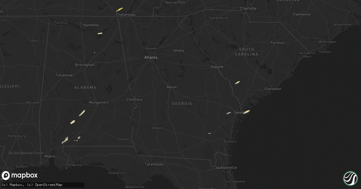
Hail Map in Georgia on May 23, 2017
Get this storm
May 23 map
$229
one time, instant access
Download today. No call, no setup
Keep the $229
Bought the map and want the full workflow? Apply the entire $229 to a subscription within 7 days. None of it is wasted.
Every map, not just this one
This buys you this map. Subscription and you get every map we run, in the markets you choose from a few cities to whole states to nationwide. Plus real-time alerts the moment a storm fires.
Contact data
Name, contact info, occupancy, even credit band for addresses in the footprint. You go from where it hit to who to call.
Become the source they trust
Unlimited branding weather history reports on demand. You already have the documented answer ready for the property owner, and you are the one who showed up with it.
Property data and RoofTrace estimates
Pull up any address you have got, its value and the exact code rules for that jurisdiction, straight from One Click Code. Then RoofTrace estimates the squares, pitch, and roof value, priced the way you price.
Storm reports in Georgia
Georgia
| Date | Description |
|---|---|
| 05/23/20175:01 PM CDT | Tornado near fort pulaski. Confirmed by pictures on social media. |
| 05/23/20174:54 PM CDT | A tornado developed on the southwest end of wilmington island and traveled northeast about 7 miles before moving out into the ocean just beyond fort pulaski. The maximu |
| 05/23/20174:52 PM CDT | Tree down on a house on cromwell rd on southern end of wilmington island. Possible tornado. |
| 05/23/20174:34 PM CDT | Power lines down on staley ave in savannah ga. |
| 05/23/20174:23 PM CDT | Large tree down in middle of old louisville rd at east us hwy 80. |
| 05/23/20173:53 PM CDT | Power pole knocked down at 324 west memorial drive. |
| 05/23/20173:40 PM CDT | Large tree branck knocked down. |
| 05/23/20172:18 PM CDT | A tree was reported down near the intersection of st paul church road and highway 19. |
| 05/23/20171:42 PM CDT | A few trees were reported down in the plainfield area where a dog shelter was also damaged. |
| 05/23/20171:10 PM CDT | A few trees were reported down near highway 112 near american legion road. |
| 05/23/20171:07 PM CDT | A tree was reported down near the intersection of highway 341 and barrett road. |
| 05/23/20171:04 PM CDT | A tree was reported down on old mt olive church road near highway 341. |
| 05/23/20171:02 PM CDT | Near the intersection of highway 159 and bowen rd changed names from hatley rd... A chicken house was reported destroyed... A mobile home was moved off of its foundatio |
| 05/23/201712:51 PM CDT | Ga highway 90 blocked due to fallen trees and power line damage. |
| 05/23/201712:50 PM CDT | Mobile home blown off of foundation with other damage to nearby homes |
| 05/23/201712:49 PM CDT | Report that a tractor trailer was flipped on i-75 near mm 93 |
| 05/23/201712:49 PM CDT | Roof was partially blown off of a house on the 200 block of allied rd |
| 05/23/201712:44 PM CDT | Ga highway 41 blocked due to fallen trees and power line damage |
| 05/23/201712:27 PM CDT | Trees... Powerlines and street signs down near county road 300. |
| 05/23/201712:16 PM CDT | Nws damage survey on 6/14 confirms an ef1 tornado touched down in lee county 3 miles south of smithville and crossed into sumter county ending near leslie. Many trees w |
| 05/23/201712:10 PM CDT | Power lines reported down on a tree on sylvan road. |
| 05/23/201711:28 AM CDT | One tree down on highway 82 west between graves and dawson. |
| 05/23/201711:04 AM CDT | Report of house damage just east of the intersection of cw lumpkin road and fountain bridge road. Reported via twitter. |
| 05/23/201710:48 AM CDT | Tree down resulted in a power outage via georgia power outage website |
| 05/23/201710:47 AM CDT | Mping report of wind damage...tree limbs or shingle damage |
| 05/23/201710:46 AM CDT | Tree limbs snapped on county road 160 |
| 05/23/201710:46 AM CDT | Damage consisted primarily of minor tree damage. A single family home suffered minor roof damage...and a carport collapsed along fountain bridge road. Rated ef0 with pe |
| 05/22/20178:51 PM CDT | A tree was reported down on a power line at 4880 dahlonega highway |
| 05/22/20178:40 PM CDT | A tree was reported down near the intersection of chamblee gap road and kelly mill road. |
| 05/22/20177:16 PM CDT | A tree was reported down near the intersection of highway 140 and thomas bluff road northeast |
| 05/22/20177:10 PM CDT | Member of public called 911 to report a brief tornado touchdown that quickly lifted back. Time estimated based on time of the call. |
| 05/22/20177:10 PM CDT | A tree was reported down at the intersection of highway 101 and spur 101 southeast . |
| 05/22/20177:10 PM CDT | A tree was reported down on old dalton road northeast. |
| 05/22/20177:05 PM CDT | A tree was reported on a home on wadsworth street northeast. |
| 05/22/20177:05 PM CDT | A tree was reported down near the intersection of chateau drive and highway 411. |
All States Impacted by Hail Map on May 23, 2017
Cities Impacted by Hail Map on May 23, 2017
- Guntersville, AL
- Langston, AL
- Scottsboro, AL
- Grant, AL
- Rosenberg, TX
- Whitsett, TX
- Calliham, TX
- Three Rivers, TX
- Campbellton, TX
- Christine, TX
- Pleasanton, TX
- Jourdanton, TX
- Missouri City, TX
- Odem, TX
- Mathis, TX
- Sinton, TX
- Industry, TX
- Sealy, TX
- Fayetteville, TX
- Cat Spring, TX
- New Ulm, TX
- Pine Apple, AL
- Minter, AL
- Hayneville, AL
- Kenedy, TX
- Pasadena, TX
- Karnes City, TX
- Rockport, TX
- Woodsboro, TX
- Portland, TX
- Beeville, TX
- Skidmore, TX
- Port Aransas, TX
- Taft, TX
- Falls City, TX
- Aransas Pass, TX
- Hilton Head Island, SC
- Daufuskie Island, SC
- Tilden, TX
- Pearsall, TX
- Batesville, TX
- Livingston, TX
- Elmendorf, TX
- Uvalde, TX
- Somerset, TX
- Von Ormy, TX
- Atascosa, TX
- Lytle, TX
- Poteet, TX
- San Antonio, TX
- Mount Pleasant, TX
- Omaha, TX
- Devine, TX
- Hondo, TX
- Whitwell, TN
- Tracy City, TN
- Elkhart, TX
- Grapeland, TX
- Oakwood, TX
- Warren, TX
- Richmond, TX
- Dilley, TX
- Beatrice, AL
- Floresville, TX
- Needville, TX
- Giddings, TX
- Refugio, TX
- Rising Star, TX
- Cisco, TX
- Baird, TX
- Cross Plains, TX
- Dale, TX
- Lockhart, TX
- Peterman, AL
- Vredenburgh, AL
- Round Top, TX
- Guy, TX
- Beasley, TX
- Damon, TX
- Wallis, TX
- Gregory, TX
- Tuscola, TX
- Abilene, TX
- Buda, TX
- Fort Stewart, GA
- East Bernard, TX
- Comanche, TX
- Carbon, TX
- Robstown, TX
- Corpus Christi, TX
- Sequatchie, TN
- Kingsville, TX
- Cotulla, TX
- Crystal City, TX
- Ingleside, TX
- Atmore, AL
- Mershon, GA
- Patterson, GA
- Blackshear, GA
- Llano, TX
- Red Rock, TX
- Fowlerton, TX
- San Diego, TX
- Orange Grove, TX
- Sabinal, TX
- George West, TX
- Round Rock, TX
- Pflugerville, TX
- Hutto, TX
- Fairfax, SC
- Ledbetter, TX
- Alleyton, TX
- Brenham, TX
- Bellville, TX
- La Grange, TX
- Brunson, SC
- Savannah, GA
- Kyle, TX
- Manor, TX
- Elgin, TX
- Fulshear, TX
- Brookshire, TX
- Rosharon, TX
- Alvin, TX
- Pearland, TX
- Flatonia, TX
- Rosanky, TX
- Waelder, TX
- Bishop, TX
- Palacios, TX
- La Coste, TX
- Natalia, TX
- Brewton, AL
- Castleberry, AL
- Paige, TX
- Smithville, TX
- Bayside, TX
- La Porte, TX
- Buchanan Dam, TX
- Oneonta, AL
- Coupland, TX
- Tivoli, TX
- Cookville, TX
- Signal Mountain, TN
- Chattanooga, TN
- Austin, TX
- McDade, TX
- Bastrop, TX
- Taylor, TX
- Lexington, TX
- Lincoln, TX
- Driftwood, TX


