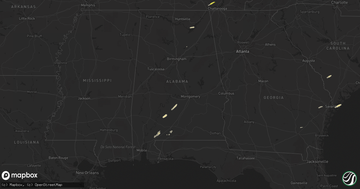
Hail Map in Alabama on May 23, 2017
Get this storm
May 23 map
$229
one time, instant access
Download today. No call, no setup
Keep the $229
Bought the map and want the full workflow? Apply the entire $229 to a subscription within 7 days. None of it is wasted.
Every map, not just this one
This buys you this map. Subscription and you get every map we run, in the markets you choose from a few cities to whole states to nationwide. Plus real-time alerts the moment a storm fires.
Contact data
Name, contact info, occupancy, even credit band for addresses in the footprint. You go from where it hit to who to call.
Become the source they trust
Unlimited branding weather history reports on demand. You already have the documented answer ready for the property owner, and you are the one who showed up with it.
Property data and RoofTrace estimates
Pull up any address you have got, its value and the exact code rules for that jurisdiction, straight from One Click Code. Then RoofTrace estimates the squares, pitch, and roof value, priced the way you price.
Storm reports in Alabama
Alabama
| Date | Description |
|---|---|
| 05/23/20174:19 PM CDT | A tree was knocked down at convict camp road at highway 79. |
| 05/23/20174:16 PM CDT | A tree was knocked down on baker mountain road at highway 79. |
| 05/23/20174:13 PM CDT | A tree was knocked down onto power lines at highway 79 at bryant mill road. |
| 05/23/20173:57 PM CDT | A tree was knocked down on honeycomb valley road. |
| 05/22/20177:45 PM CDT | Large limbs and trees reported down in and around the sylacauga area. Time and winds of 46mph estimated from radar. |
All States Impacted by Hail Map on May 23, 2017
Cities Impacted by Hail Map on May 23, 2017
- Guntersville, AL
- Langston, AL
- Scottsboro, AL
- Grant, AL
- Rosenberg, TX
- Whitsett, TX
- Calliham, TX
- Three Rivers, TX
- Campbellton, TX
- Christine, TX
- Pleasanton, TX
- Jourdanton, TX
- Missouri City, TX
- Odem, TX
- Mathis, TX
- Sinton, TX
- Industry, TX
- Sealy, TX
- Fayetteville, TX
- Cat Spring, TX
- New Ulm, TX
- Pine Apple, AL
- Minter, AL
- Hayneville, AL
- Kenedy, TX
- Pasadena, TX
- Karnes City, TX
- Rockport, TX
- Woodsboro, TX
- Portland, TX
- Beeville, TX
- Skidmore, TX
- Port Aransas, TX
- Taft, TX
- Falls City, TX
- Aransas Pass, TX
- Hilton Head Island, SC
- Daufuskie Island, SC
- Tilden, TX
- Pearsall, TX
- Batesville, TX
- Livingston, TX
- Elmendorf, TX
- Uvalde, TX
- Somerset, TX
- Von Ormy, TX
- Atascosa, TX
- Lytle, TX
- Poteet, TX
- San Antonio, TX
- Mount Pleasant, TX
- Omaha, TX
- Devine, TX
- Hondo, TX
- Whitwell, TN
- Tracy City, TN
- Elkhart, TX
- Grapeland, TX
- Oakwood, TX
- Warren, TX
- Richmond, TX
- Dilley, TX
- Beatrice, AL
- Floresville, TX
- Needville, TX
- Giddings, TX
- Refugio, TX
- Rising Star, TX
- Cisco, TX
- Baird, TX
- Cross Plains, TX
- Dale, TX
- Lockhart, TX
- Peterman, AL
- Vredenburgh, AL
- Round Top, TX
- Guy, TX
- Beasley, TX
- Damon, TX
- Wallis, TX
- Gregory, TX
- Tuscola, TX
- Abilene, TX
- Buda, TX
- Fort Stewart, GA
- East Bernard, TX
- Comanche, TX
- Carbon, TX
- Robstown, TX
- Corpus Christi, TX
- Sequatchie, TN
- Kingsville, TX
- Cotulla, TX
- Crystal City, TX
- Ingleside, TX
- Atmore, AL
- Mershon, GA
- Patterson, GA
- Blackshear, GA
- Llano, TX
- Red Rock, TX
- Fowlerton, TX
- San Diego, TX
- Orange Grove, TX
- Sabinal, TX
- George West, TX
- Round Rock, TX
- Pflugerville, TX
- Hutto, TX
- Fairfax, SC
- Ledbetter, TX
- Alleyton, TX
- Brenham, TX
- Bellville, TX
- La Grange, TX
- Brunson, SC
- Savannah, GA
- Kyle, TX
- Manor, TX
- Elgin, TX
- Fulshear, TX
- Brookshire, TX
- Rosharon, TX
- Alvin, TX
- Pearland, TX
- Flatonia, TX
- Rosanky, TX
- Waelder, TX
- Bishop, TX
- Palacios, TX
- La Coste, TX
- Natalia, TX
- Brewton, AL
- Castleberry, AL
- Paige, TX
- Smithville, TX
- Bayside, TX
- La Porte, TX
- Buchanan Dam, TX
- Oneonta, AL
- Coupland, TX
- Tivoli, TX
- Cookville, TX
- Signal Mountain, TN
- Chattanooga, TN
- Austin, TX
- McDade, TX
- Bastrop, TX
- Taylor, TX
- Lexington, TX
- Lincoln, TX
- Driftwood, TX


