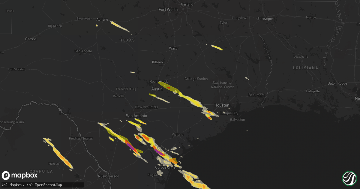
Hail Map on May 23, 2017
Get this storm
May 23 map
$229
one time, instant access
Download today. No call, no setup
Keep the $229
Bought the map and want the full workflow? Apply the entire $229 to a subscription within 7 days. None of it is wasted.
Every map, not just this one
This buys you this map. Subscription and you get every map we run, in the markets you choose from a few cities to whole states to nationwide. Plus real-time alerts the moment a storm fires.
Contact data
Name, contact info, occupancy, even credit band for addresses in the footprint. You go from where it hit to who to call.
Become the source they trust
Unlimited branding weather history reports on demand. You already have the documented answer ready for the property owner, and you are the one who showed up with it.
Property data and RoofTrace estimates
Pull up any address you have got, its value and the exact code rules for that jurisdiction, straight from One Click Code. Then RoofTrace estimates the squares, pitch, and roof value, priced the way you price.
States Impacted by Hail Map on May 23, 2017
Storm reports
Louisiana
| Date | Description |
|---|---|
| 05/23/20176:55 PM CDT | Tree down across e. Linton road took out power line 200 yards north of pilkington cemetary. Road cleared... Swepco responded but power out on e linton and oak leaf trai |
| 05/23/20175:50 PM CDT | Multiple trees reported down on cass county road and stateline road northwest of vivian... Some trees blocking roads... Power lines down... Large limbs down as well. |
| 05/23/20175:45 PM CDT | Trees reported down on old atlanta road north of vivian and nickel size hail reported at the police department in vivian. |
South Carolina
| Date | Description |
|---|---|
| 05/23/20171:00 PM CDT | Colleton county sheriffs office reported three trees blocking roadway...treu street and shady dell lane...magwood bryant road and wood road...charleston highway and bon |
North Carolina
| Date | Description |
|---|---|
| 05/23/20175:16 PM CDT | Nws storm survey confirms ef1 tornado damage just se of gum neck in tyrrell county. Max estimated winds were 100 mph... With a path length of 0.6 miles and max path wid |
| 05/23/20175:10 PM CDT | Public reported trees down... Crops flattened... And tops torn out of trees near residence in gum branch. Damage due to possible tornado. Time based on radar. |
| 05/23/20174:19 PM CDT | Police officer reported a tornado on the ground crossing us 421. |
| 05/23/20174:12 PM CDT | *** 1 inj *** emergency manager reported a mobile home overturned in the bareskin community near salemburg. Minor injuries reported. |
| 05/23/20173:40 PM CDT | Emergency manager reported the autryville volunteer fire department was destroyed by a tornado. |
| 05/23/20173:38 PM CDT | Multiple trees and limbs down along hwy 24 in autryville. Tornado possible. |
| 05/23/20173:00 PM CDT | Report of damage to 2 barns. Time estimated by radar. |
| 05/23/20172:45 PM CDT | Report of damage to 2 barns on sandy grove road. Time estimated by radar. |
| 05/23/20172:45 PM CDT | Report of trees down on sansbury lane. Time estimated by radar. |
| 05/23/20172:45 PM CDT | Nws survey team confirms a tornado near parkton nc. Preliminary rating ef-0 with 75 mph winds... A width of 30 yards... And path length of 2.2 miles. More details to fo |
| 05/23/20173:40 AM CDT | Tree down on stout farm road. Possible rfd. Time estimated by radar. |
Texas
| Date | Description |
|---|---|
| 05/23/20176:35 PM CDT | Part of fm-109 in frelsburg blocked by a downed tree. |
| 05/23/20176:18 PM CDT | Fayette county em reports damage to trees and a structure west of warrenton. |
| 05/23/20176:14 PM CDT | Quarter sized hail at cabelas in buda |
| 05/23/20176:01 PM CDT | Reports of large oak trees snapped on the south side of giddings. |
| 05/23/20176:01 PM CDT | Quarter sized hail along interstate 37 near leming. Time estimated from radar. |
| 05/23/20176:00 PM CDT | Quarter up to the size of half dollars in giddings. Time estimated from radar. |
| 05/23/20176:00 PM CDT | Storm spotter measured 75 mph wind gust in giddings. Also reported quarter sized hail. Time estimated from radar. |
| 05/23/20175:50 PM CDT | Received photos of hail up to the size of half dollars accumulated on the ground in paige. Also received photos of extensive damage to the siding of a house from wind-d |
| 05/23/20175:49 PM CDT | Hail slightly larger than quarters in paige. Time estimated from radar. |
| 05/23/20175:39 PM CDT | Golf ball sized hail east of elgin. |
| 05/23/20175:34 PM CDT | Bastrop county em reports widespread wind damage in and around elgin. Reports of both power lines and trees downed across the area. |
| 05/23/20175:32 PM CDT | Small tree limbs down in elgin. |
| 05/23/20175:31 PM CDT | Quarter size hail reported along highway 290 just west of elgin. Time estimated from radar. |
| 05/23/20175:30 PM CDT | Quarter sized hail in somerset. Time estimated from radar. |
| 05/23/20175:22 PM CDT | Quarter sized hail near the bexar and atascosa county line. Time estimated from radar. |
| 05/23/20175:20 PM CDT | Public report of golf ball size hail along hwy 181. |
| 05/23/20175:18 PM CDT | Quarter sized hail report from spotter. |
| 05/23/20175:16 PM CDT | Large tree snapped in half. |
| 05/23/20175:16 PM CDT | Hail up to the size of quarters reported in pflugerville |
| 05/23/20175:14 PM CDT | Quarter sized hail reported near interstate 35 and toll road 45 in south round rock. |
| 05/23/20175:01 PM CDT | Quarter size hail near percilla. |
| 05/23/20174:44 PM CDT | Quarter size hail reported on county road 1705 |
| 05/23/20174:34 PM CDT | Emergency manager reports power lines down across highway 83 south of uvalde. Time estimated from radar. |
| 05/23/20174:30 PM CDT | Quarter sized hail on cr 130 near elkhart |
| 05/23/20177:10 AM CDT | Coronado camp area reported several large trees blown down. Hail ranged from pea to marble size. |
| 05/22/20178:30 PM CDT | Rockport nos measured thunderstorm gust of 51 kts |
| 05/22/20178:22 PM CDT | Ping pong ball size hail near sparks colony drive. |
| 05/22/20178:15 PM CDT | Images submitted of power lines down across hwy 181 |
| 05/22/20178:10 PM CDT | Series of fences blown down in western league city along maple leaf between league city pkwy and 528. |
| 05/22/20178:09 PM CDT | Images submitted of radio tower damaged/partially downed east of taft |
| 05/22/20178:08 PM CDT | Numerous trees damaged in taft. Report via social media |
| 05/22/20177:54 PM CDT | Images sbumitted of large trees down and storage sheds flipped over |
| 05/22/20177:51 PM CDT | A local report indicates 60 MPH wind near SINTON |
| 05/22/20177:51 PM CDT | A local report indicates 1.00 inch wind near SINTON |
| 05/22/20177:50 PM CDT | Large tree limb downed on top of an suv on masterson street near the disney street intersection. |
| 05/22/20177:40 PM CDT | Ham operator reports golf ball size hail. |
| 05/22/20177:33 PM CDT | Video submitted of intense winds blowing over large trees near corrigan rd in skimore |
| 05/22/20177:31 PM CDT | Mesonet observation site measured 61 mph gust |
| 05/22/20177:30 PM CDT | Numerous large trees down in needville subdivision. |
| 05/22/20177:30 PM CDT | A local report indicates 1.75 inch wind near 3 SE ROSENBERG |
| 05/22/20177:26 PM CDT | Tx dps reports large tress split ... Multiple power poles down... Missing shingles on roofs... And lots of debris on the ground . |
| 05/22/20177:26 PM CDT | Grain silos down and damage to bonnie plant farm. |
| 05/22/20177:25 PM CDT | A local report indicates 81 MPH wind near 4 SW BEEVILLE |
| 05/22/20177:25 PM CDT | Fort bend co sheriffs office reports a trampoline around a light pole and fence down in beasley via twitter |
| 05/22/20177:22 PM CDT | Tx dps official reports multiple telephone poles and large branches down. |
| 05/22/20177:21 PM CDT | A local report indicates 81 MPH wind near 4 SW BEEVILLE |
| 05/22/20177:18 PM CDT | Trees down on fm-350 south. |
| 05/22/20177:18 PM CDT | Picture submitted of tennis ball sized hail. |
| 05/22/20177:15 PM CDT | Multiple reports of damage out of simonton including large limbs down... Fence down... Roof damage... And power lines down via fbcso twitter |
| 05/22/20177:10 PM CDT | Nws survey team concluded a macroburst of straight line winds impacted bee and san patricio co. Greatest concentration of damage occurred roughly along a 40 mile long p |
| 05/22/20177:08 PM CDT | Storm spotter reports 1.5 inch hail. |
| 05/22/20177:08 PM CDT | Pictures of significant property damage near mineral |
| 05/22/20177:00 PM CDT | Off duty nws employee reports car windows blown out and part of a roof blown off at sealy high school |
| 05/22/20177:00 PM CDT | 18-wheel truck blown over on i-10 near sealy reported by off-duty nws employee. |
| 05/22/20177:00 PM CDT | Tree limbs and fences down. |
Georgia
| Date | Description |
|---|---|
| 05/23/20175:01 PM CDT | Tornado near fort pulaski. Confirmed by pictures on social media. |
| 05/23/20174:54 PM CDT | A tornado developed on the southwest end of wilmington island and traveled northeast about 7 miles before moving out into the ocean just beyond fort pulaski. The maximu |
| 05/23/20174:52 PM CDT | Tree down on a house on cromwell rd on southern end of wilmington island. Possible tornado. |
| 05/23/20174:34 PM CDT | Power lines down on staley ave in savannah ga. |
| 05/23/20174:23 PM CDT | Large tree down in middle of old louisville rd at east us hwy 80. |
| 05/23/20173:53 PM CDT | Power pole knocked down at 324 west memorial drive. |
| 05/23/20173:40 PM CDT | Large tree branck knocked down. |
| 05/23/20172:18 PM CDT | A tree was reported down near the intersection of st paul church road and highway 19. |
| 05/23/20171:42 PM CDT | A few trees were reported down in the plainfield area where a dog shelter was also damaged. |
| 05/23/20171:10 PM CDT | A few trees were reported down near highway 112 near american legion road. |
| 05/23/20171:07 PM CDT | A tree was reported down near the intersection of highway 341 and barrett road. |
| 05/23/20171:04 PM CDT | A tree was reported down on old mt olive church road near highway 341. |
| 05/23/20171:02 PM CDT | Near the intersection of highway 159 and bowen rd changed names from hatley rd... A chicken house was reported destroyed... A mobile home was moved off of its foundatio |
| 05/23/201712:51 PM CDT | Ga highway 90 blocked due to fallen trees and power line damage. |
| 05/23/201712:50 PM CDT | Mobile home blown off of foundation with other damage to nearby homes |
| 05/23/201712:49 PM CDT | Report that a tractor trailer was flipped on i-75 near mm 93 |
| 05/23/201712:49 PM CDT | Roof was partially blown off of a house on the 200 block of allied rd |
| 05/23/201712:44 PM CDT | Ga highway 41 blocked due to fallen trees and power line damage |
| 05/23/201712:27 PM CDT | Trees... Powerlines and street signs down near county road 300. |
| 05/23/201712:16 PM CDT | Nws damage survey on 6/14 confirms an ef1 tornado touched down in lee county 3 miles south of smithville and crossed into sumter county ending near leslie. Many trees w |
| 05/23/201712:10 PM CDT | Power lines reported down on a tree on sylvan road. |
| 05/23/201711:28 AM CDT | One tree down on highway 82 west between graves and dawson. |
| 05/23/201711:04 AM CDT | Report of house damage just east of the intersection of cw lumpkin road and fountain bridge road. Reported via twitter. |
| 05/23/201710:48 AM CDT | Tree down resulted in a power outage via georgia power outage website |
| 05/23/201710:47 AM CDT | Mping report of wind damage...tree limbs or shingle damage |
| 05/23/201710:46 AM CDT | Tree limbs snapped on county road 160 |
| 05/23/201710:46 AM CDT | Damage consisted primarily of minor tree damage. A single family home suffered minor roof damage...and a carport collapsed along fountain bridge road. Rated ef0 with pe |
| 05/22/20178:51 PM CDT | A tree was reported down on a power line at 4880 dahlonega highway |
| 05/22/20178:40 PM CDT | A tree was reported down near the intersection of chamblee gap road and kelly mill road. |
| 05/22/20177:16 PM CDT | A tree was reported down near the intersection of highway 140 and thomas bluff road northeast |
| 05/22/20177:10 PM CDT | Member of public called 911 to report a brief tornado touchdown that quickly lifted back. Time estimated based on time of the call. |
| 05/22/20177:10 PM CDT | A tree was reported down on old dalton road northeast. |
| 05/22/20177:10 PM CDT | A tree was reported down at the intersection of highway 101 and spur 101 southeast . |
| 05/22/20177:05 PM CDT | A tree was reported down near the intersection of chateau drive and highway 411. |
| 05/22/20177:05 PM CDT | A tree was reported on a home on wadsworth street northeast. |
Illinois
| Date | Description |
|---|---|
| 05/23/20174:30 PM CDT | Weak landspout tornado briefly touched down in a field near assumption. Report relayed by media. |
| 05/23/20172:55 PM CDT | A tornado was observed by eyewitnesses along with radar debris signature. Eyewitness said that they had to slow down and wait for the tornado to pass in front of them o |
| 05/22/20178:05 PM CDT | Weak landspout tornado in a field. |
Alabama
| Date | Description |
|---|---|
| 05/23/20174:19 PM CDT | A tree was knocked down at convict camp road at highway 79. |
| 05/23/20174:16 PM CDT | A tree was knocked down on baker mountain road at highway 79. |
| 05/23/20174:13 PM CDT | A tree was knocked down onto power lines at highway 79 at bryant mill road. |
| 05/23/20173:57 PM CDT | A tree was knocked down on honeycomb valley road. |
| 05/22/20177:45 PM CDT | Large limbs and trees reported down in and around the sylacauga area. Time and winds of 46mph estimated from radar. |
Tennessee
| Date | Description |
|---|---|
| 05/23/20176:55 AM CDT | Several trees down. |
| 05/22/20177:10 PM CDT | Spotter reported quarter sized hail in whitwell. |
| 05/22/20177:10 PM CDT | Huge uprooted trees in the whitwell area. |
| 05/22/20177:05 PM CDT | Trees down in whitwell area. |
Cities Impacted by Hail Map on May 23, 2017
- Guntersville, AL
- Langston, AL
- Scottsboro, AL
- Grant, AL
- Rosenberg, TX
- Whitsett, TX
- Calliham, TX
- Three Rivers, TX
- Campbellton, TX
- Christine, TX
- Pleasanton, TX
- Jourdanton, TX
- Missouri City, TX
- Odem, TX
- Mathis, TX
- Sinton, TX
- Industry, TX
- Sealy, TX
- Fayetteville, TX
- Cat Spring, TX
- New Ulm, TX
- Pine Apple, AL
- Minter, AL
- Hayneville, AL
- Kenedy, TX
- Pasadena, TX
- Karnes City, TX
- Rockport, TX
- Woodsboro, TX
- Portland, TX
- Beeville, TX
- Skidmore, TX
- Port Aransas, TX
- Taft, TX
- Falls City, TX
- Aransas Pass, TX
- Hilton Head Island, SC
- Daufuskie Island, SC
- Tilden, TX
- Pearsall, TX
- Batesville, TX
- Livingston, TX
- Elmendorf, TX
- Uvalde, TX
- Somerset, TX
- Von Ormy, TX
- Atascosa, TX
- Lytle, TX
- Poteet, TX
- San Antonio, TX
- Mount Pleasant, TX
- Omaha, TX
- Devine, TX
- Hondo, TX
- Whitwell, TN
- Tracy City, TN
- Elkhart, TX
- Grapeland, TX
- Oakwood, TX
- Warren, TX
- Richmond, TX
- Dilley, TX
- Beatrice, AL
- Floresville, TX
- Needville, TX
- Giddings, TX
- Refugio, TX
- Rising Star, TX
- Cisco, TX
- Baird, TX
- Cross Plains, TX
- Dale, TX
- Lockhart, TX
- Peterman, AL
- Vredenburgh, AL
- Round Top, TX
- Guy, TX
- Beasley, TX
- Damon, TX
- Wallis, TX
- Gregory, TX
- Tuscola, TX
- Abilene, TX
- Buda, TX
- Fort Stewart, GA
- East Bernard, TX
- Comanche, TX
- Carbon, TX
- Robstown, TX
- Corpus Christi, TX
- Sequatchie, TN
- Kingsville, TX
- Cotulla, TX
- Crystal City, TX
- Ingleside, TX
- Atmore, AL
- Mershon, GA
- Patterson, GA
- Blackshear, GA
- Llano, TX
- Red Rock, TX
- Fowlerton, TX
- San Diego, TX
- Orange Grove, TX
- Sabinal, TX
- George West, TX
- Round Rock, TX
- Pflugerville, TX
- Hutto, TX
- Fairfax, SC
- Ledbetter, TX
- Alleyton, TX
- Brenham, TX
- Bellville, TX
- La Grange, TX
- Brunson, SC
- Savannah, GA
- Kyle, TX
- Manor, TX
- Elgin, TX
- Fulshear, TX
- Brookshire, TX
- Rosharon, TX
- Alvin, TX
- Pearland, TX
- Flatonia, TX
- Rosanky, TX
- Waelder, TX
- Bishop, TX
- Palacios, TX
- La Coste, TX
- Natalia, TX
- Brewton, AL
- Castleberry, AL
- Paige, TX
- Smithville, TX
- Bayside, TX
- La Porte, TX
- Buchanan Dam, TX
- Oneonta, AL
- Coupland, TX
- Tivoli, TX
- Cookville, TX
- Signal Mountain, TN
- Chattanooga, TN
- Austin, TX
- McDade, TX
- Bastrop, TX
- Taylor, TX
- Lexington, TX
- Lincoln, TX
- Driftwood, TX