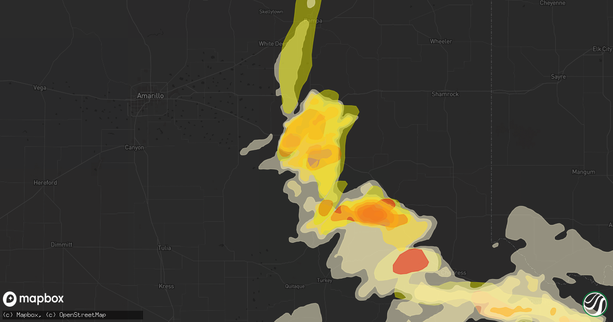
Hail Map in Clarendon, TX on May 22, 2016
Get this storm
May 22 map
$229
one time, instant access
Download today. No call, no setup
Keep the $229
Bought the map and want the full workflow? Apply the entire $229 to a subscription within 7 days. None of it is wasted.
Every map, not just this one
This buys you this map. Subscription and you get every map we run, in the markets you choose from a few cities to whole states to nationwide. Plus real-time alerts the moment a storm fires.
Contact data
Name, contact info, occupancy, even credit band for addresses in the footprint. You go from where it hit to who to call.
Become the source they trust
Unlimited branding weather history reports on demand. You already have the documented answer ready for the property owner, and you are the one who showed up with it.
Property data and RoofTrace estimates
Pull up any address you have got, its value and the exact code rules for that jurisdiction, straight from One Click Code. Then RoofTrace estimates the squares, pitch, and roof value, priced the way you price.
Storm reports in Clarendon, TX
Clarendon, TX
| Date | Description |
|---|---|
| 05/22/20166:33 PM CDT | Late report...hail reported multiple thunderstorms passed over location...estimated time range provided by spotter adjusted with doppler radar. |
| 05/22/20166:31 PM CDT | A local report indicates 1.50 inch wind near CLARENDON |
| 05/22/20166:30 PM CDT | Golf ball size hail was falling south of clarendon college. |
| 05/22/20166:08 PM CDT | Quarter size hail and very heavy rain reported with storm over howardwick. Minor ponding of water on the grass and roadways. |
| 05/22/20165:41 PM CDT | Large barrel tornado on the ground. |
| 05/22/20165:41 PM CDT | Cone tornado reported on the ground. |
| 05/22/20165:40 PM CDT | A local report indicates a tornado near 4 N HOWARDWICK |
| 05/22/20165:40 PM CDT | Tornado from multiple spotter reports and seen on live storm chaser video. |
| 05/22/20165:39 PM CDT | Tornado 3.5 miles northwest of howardwick. On ground 9 minutes. Seen on live storm chaser video and confirmed by survey. |
| 05/22/20165:34 PM CDT | Brief rope tornado... Lasted 30 seconds. |
| 05/22/20165:31 PM CDT | Multiple reports of tornadoes near howardwick... Tx. Strong rotating wall cloud still noted. |
| 05/22/20165:30 PM CDT | Brief rope tornado 3 miles northwest of howardwick...lasted 30 seconds. Multiple reports. Strong rotating wall cloud still noted. |
| 05/22/20165:30 PM CDT | Golf ball sized hail fell with nearly stationary thunderstorm. |
| 05/22/20165:10 PM CDT | Quarter size hail fell on highway 70. |
| 05/22/20164:18 PM CDT | Late report...quarter sized hail fell with first storm that passed over clarendon. |
| 05/22/20163:51 PM CDT | Hail larger than golf balls and heavy rain were slowing traffic at us highway 287 and county road 3. |
All States Impacted by Hail Map on May 22, 2016
All Cities Impacted by Hail Map on May 22, 2016
- Platte, SD
- Kimball, SD
- White Lake, SD
- Ypsilanti, ND
- Jamestown, ND
- Gackle, ND
- Selby, SD
- Edinburg, ND
- Hamill, SD
- Stratford, TX
- Wilson, OK
- Ardmore, OK
- Lone Grove, OK
- Maxwell, NE
- Stapleton, NE
- Mission, SD
- Valentine, NE
- Lakin, KS
- Deerfield, KS
- Holcomb, KS
- Childress, TX
- Quanah, TX
- Paducah, TX
- Chillicothe, TX
- Montpelier, ND
- Kulm, ND
- Jud, ND
- Lakeview, TX
- Memphis, TX
- White River, SD
- Big Spring, TX
- Clarendon, TX
- Lorenzo, TX
- Colome, SD
- Sparks, NE
- Sargent, NE
- Norris, SD
- Marion, SC
- Parmelee, SD
- Mountain View, OK
- Gruver, TX
- Canadian, TX
- Stinnett, TX
- Spearman, TX
- Perryton, TX
- Miami, TX
- Pampa, TX
- Woodworth, ND
- Pingree, ND
- Walters, OK
- Grandfield, OK
- Devol, OK
- Gail, TX
- Mound City, SD
- Fredonia, ND
- Lehr, ND
- Kilgore, NE
- Cody, NE
- Nenzel, NE
- Dalhart, TX
- Winner, SD
- Hemingford, NE
- Belvidere, SD
- Crowell, TX
- Post, TX
- Herreid, SD
- Crary, ND
- Comstock, TX
- Dryden, TX
- Davidson, OK
- Binford, ND
- Cooperstown, ND
- Wood Lake, NE
- Ralls, TX
- Floydada, TX
- Henrietta, TX
- Scotland, TX
- Windthorst, TX
- Tell, TX
- Hedley, TX
- Wishek, ND
- Lakota, ND
- Garden City, TX
- Groom, TX
- White Deer, TX
- Liberal, KS
- Hugoton, KS
- Hooker, OK
- Tahoka, TX
- Odonnell, TX
- Ashley, ND
- Lenorah, TX
- Knott, TX
- Stanton, TX
- Arnold, NE
- Brady, NE
- Copeland, KS
- Sublette, KS
- Wakpala, SD
- Thedford, NE
- Altus, OK
- Atwood, KS
- Hoople, ND
- Burke, SD
- Gregory, SD
- Ravenna, NE
- Lamesa, TX
- Crosbyton, TX
- Medina, ND
- Tappen, ND
- Bowie, TX
- Jacksboro, TX
- Alvord, TX
- Chico, TX
- Sunset, TX
- Bellevue, TX
- North Platte, NE
- Reidsville, NC
- Garden City, KS
- Mchenry, ND
- New Rockford, ND
- Leoti, KS
- Lockney, TX
- Byers, TX
- Brooten, MN
- Pukwana, SD
- Vernon, TX
- Burlington, NC
- Bemidji, MN
- Matador, TX
- Flomot, TX
- Justiceburg, TX
- Tarzan, TX
- Eagle Butte, SD
- Gettysburg, SD
- Dickey, ND
- Holliday, TX
- Iowa Park, TX
- Electra, TX
- Turtle Lake, ND
- Butte, ND
- Ruso, ND
- Carrington, ND
- Glenham, SD
- Turkey, TX
- Warwick, ND
- Grace City, ND
- Ulysses, KS
- Eldorado, OK
- Gould, OK
- Whitman, NE
- Crookston, NE
- Springview, NE
- Temple, OK
- Goodrich, ND
- Wing, ND
- Guymon, OK
- Hardesty, OK
- Carnegie, OK
- Elmer, OK
- Marienthal, KS
- Scott City, KS
- Plains, KS
- Voltaire, ND
- Frederick, OK
- Claude, TX
- Lake Andes, SD
- Geddes, SD
- Ackerly, TX
- Oakley, KS
- Saint Francis, SD
- Tuthill, SD
- Port Arthur, TX
- Washburn, ND
- Underwood, ND
- Gainesville, TX
- Collinsville, TX
- Hague, ND
- Brocket, ND
- Pelican Rapids, MN
- Menahga, MN
- Hollister, OK
- Goodwell, OK
- Mizpah, MN
- Northome, MN
- Gibbon, NE
- Trail City, SD
- Sutherland, NE
- Tryon, NE
- Harrold, TX
- Dallas, SD
- Aneta, ND
- Galveston, TX
- Devers, TX
- Olustee, OK
- Odell, TX
- Tipton, OK
- Zeeland, ND
- Eureka, SD
- Artesian, SD
- Smith Center, KS
- Max, ND
- Garrison, ND
- Langdon, ND
- Alsen, ND
- Pierre, SD
- Pekin, ND
- Tolna, ND
- Balko, OK
- Roosevelt, OK
- Hobart, OK
- Reliance, SD
- Kennebec, SD
- Wellington, TX
- Tioga, TX
- Geronimo, OK
- Oxford, NE
- Hollis, OK
- Corsica, SD
- Armour, SD
- Cee Vee, TX
- Harrison, SD
- Balfour, ND
- Cozad, NE
- Duke, OK
- Muenster, TX
- Forestburg, TX
- Dawson, ND
- Stickney, SD
- Waterbury, NE
- Grafton, ND
- Edgeley, ND
- Roaring Springs, TX
- Winona, KS
- Graham, NC
- Snow Camp, NC
- Mangum, OK
- Gothenburg, NE
- Burlington, OK
- Kiowa, KS
- Hazelton, KS
- Murdo, SD
- Draper, SD
- Comstock, NE
- Glenfield, ND
- Midland, TX
- Big Lake, TX
- Glenwood, MN
- Midland, SD
- Alliance, NE
- Mills, NE
- Arthur, NE
- Ringling, OK
- Niagara, ND
- Randlett, OK
- Lankin, ND
- Hay Springs, NE
- Mercer, ND
- Chamberlain, SD
- Grant, NE
- Ogallala, NE
- Gotebo, OK
- Plankinton, SD
- Altus Afb, OK
- Berlin, ND
- Oklaunion, TX
- Headrick, OK
- Loveland, OK
- Quitaque, TX
- Spiritwood, ND
- Sanborn, ND
- Dunning, NE
- Pamplico, SC
- Long Valley, SD
- Napoleon, ND
- Scottsbluff, NE
- Gering, NE
- Mapleton, IA
- Hinton, IA
- Parks, NE
- Arapahoe, NE
- Higgins, TX
- Hyannis, NE
- Newman Grove, NE
- Villard, MN
- Sauk Centre, MN
- Liberty, TX
- Tower City, ND
- Page, ND
- Wichita Falls, TX
- Ridgeview, SD
- Battle Creek, IA
- Chatham, VA
- Lawton, ND
- Keystone, NE
- Marion, ND
- Buchanan, ND
- Tuttle, ND
- Wadena, MN
- Gresham, SC
- Crystal, ND
- Lone Wolf, OK
- Bloomington, NE
- Wagner, SD
- Litchville, ND
- Mcville, ND
- Lamoure, ND
- Fullerton, ND
- Alva, OK
- Gunter, TX
- Mobridge, SD
- Pollock, SD
- Lemoyne, NE
- Florence, SC
- Lelia Lake, TX


