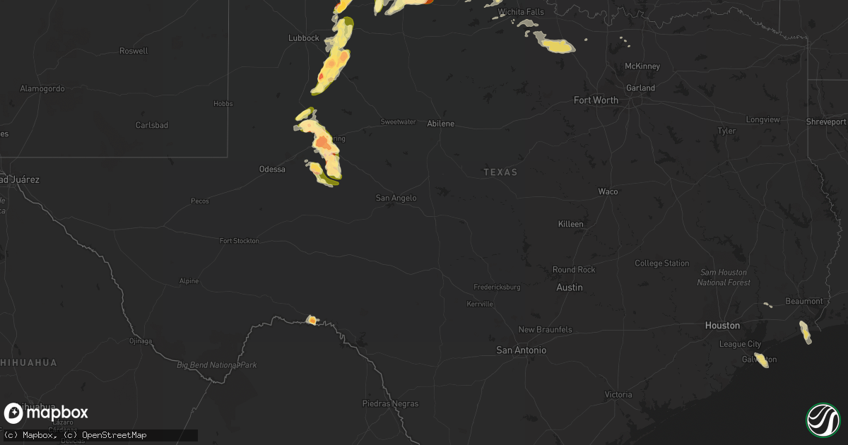
Hail Map in Texas on May 22, 2016
Get this storm
May 22 map
$229
one time, instant access
Download today. No call, no setup
Keep the $229
Bought the map and want the full workflow? Apply the entire $229 to a subscription within 7 days. None of it is wasted.
Every map, not just this one
This buys you this map. Subscription and you get every map we run, in the markets you choose from a few cities to whole states to nationwide. Plus real-time alerts the moment a storm fires.
Contact data
Name, contact info, occupancy, even credit band for addresses in the footprint. You go from where it hit to who to call.
Become the source they trust
Unlimited branding weather history reports on demand. You already have the documented answer ready for the property owner, and you are the one who showed up with it.
Property data and RoofTrace estimates
Pull up any address you have got, its value and the exact code rules for that jurisdiction, straight from One Click Code. Then RoofTrace estimates the squares, pitch, and roof value, priced the way you price.
Storm reports in Texas
Texas
| Date | Description |
|---|---|
| 05/22/20166:59 PM CDT | Intersection of us 87 and todd road south of big spring. |
| 05/22/20166:59 PM CDT | Tornado viewed from highway 70 |
| 05/22/20166:59 PM CDT | Multi-vortex tornado noted |
| 05/22/20166:57 PM CDT | Tornado on ground for 8 minutes beginning 13 miles sse of farnsworth. Tornado damaged barn near county road 8 in southwestern ochiltree county and became a large multi- |
| 05/22/20166:55 PM CDT | A local report indicates 1.75 inch wind near CEDAR HILL |
| 05/22/20166:53 PM CDT | A local report indicates a tornado near 14 SSE WAKA |
| 05/22/20166:53 PM CDT | Large rain wrapped tornado |
| 05/22/20166:52 PM CDT | A local report indicates 1.25 inch wind near POST |
| 05/22/20166:52 PM CDT | Large cone for 4-5 min...now rain wrapped. Trees debarked. |
| 05/22/20166:51 PM CDT | On warren street. |
| 05/22/20166:50 PM CDT | Storm spotter reported tornado on the ground. |
| 05/22/20166:50 PM CDT | A local report indicates a tornado near 1 S LAKEVIEW |
| 05/22/20166:49 PM CDT | Twin tornadoes on the ground. |
| 05/22/20166:45 PM CDT | A cone tornado was reported on the ground...then lifted at 653 pm cdt. |
| 05/22/20166:45 PM CDT | Spotter reported tornado 11 sse of waka. |
| 05/22/20166:45 PM CDT | Telephone poles down on fm 281 ese of spearman |
| 05/22/20166:45 PM CDT | A local report indicates 60 MPH wind near 2 NNE FLOYDADA |
| 05/22/20166:45 PM CDT | 6-7 diameter trees blown over |
| 05/22/20166:44 PM CDT | A local report indicates a tornado near 1 S LAKEVIEW |
| 05/22/20166:44 PM CDT | Tornado on ground 8 minutes 11 miles sse of waka. |
| 05/22/20166:42 PM CDT | A local report indicates a tornado near 13 SSE WAKA |
| 05/22/20166:42 PM CDT | A local report indicates 3.00 inch wind near 6 NW ELBOW |
| 05/22/20166:38 PM CDT | A local report indicates 1.75 inch wind near FLOYDADA |
| 05/22/20166:36 PM CDT | Power lines pushed over on hwy 114 |
| 05/22/20166:33 PM CDT | Late report...hail reported multiple thunderstorms passed over location...estimated time range provided by spotter adjusted with doppler radar. |
| 05/22/20166:31 PM CDT | A local report indicates 1.50 inch wind near CLARENDON |
| 05/22/20166:30 PM CDT | 1 mile west of scenic mountain hospital in big spring |
| 05/22/20166:30 PM CDT | Golf ball size hail was falling south of clarendon college. |
| 05/22/20166:30 PM CDT | A few hailstones as large as golfballs but most were the size of quarters. |
| 05/22/20166:25 PM CDT | A local report indicates 65 MPH wind near 1 SE RALLS |
| 05/22/20166:24 PM CDT | Mm 176 on interstate 20. |
| 05/22/20166:22 PM CDT | A local report indicates 1.75 inch wind near POST |
| 05/22/20166:20 PM CDT | A local report indicates 62 MPH wind near 1 SE RALLS |
| 05/22/20166:11 PM CDT | Quarter sized hail with water over tx highway 759. |
| 05/22/20166:08 PM CDT | Quarter size hail and very heavy rain reported with storm over howardwick. Minor ponding of water on the grass and roadways. |
| 05/22/20166:02 PM CDT | A local report indicates 1.25 inch wind near 12 SE SPEARMAN |
| 05/22/20165:55 PM CDT | Half inch to golf ball size hail. |
| 05/22/20165:49 PM CDT | On hwy 84 |
| 05/22/20165:46 PM CDT | A local report indicates 2.50 inch wind near 6 ESE LAKEVIEW |
| 05/22/20165:45 PM CDT | Brief tornado touchdown...wall cloud has become rain wrapped. |
| 05/22/20165:42 PM CDT | On hwy 84 |
| 05/22/20165:41 PM CDT | Large barrel tornado on the ground. |
| 05/22/20165:41 PM CDT | Cone tornado reported on the ground. |
| 05/22/20165:40 PM CDT | Tornado from multiple spotter reports and seen on live storm chaser video. |
| 05/22/20165:40 PM CDT | A local report indicates a tornado near 4 N HOWARDWICK |
| 05/22/20165:40 PM CDT | Broken car windows |
| 05/22/20165:39 PM CDT | Tornado 3.5 miles northwest of howardwick. On ground 9 minutes. Seen on live storm chaser video and confirmed by survey. |
| 05/22/20165:38 PM CDT | Measured golf ball sized hail...most hail are quarter to half dollar sized. |
| 05/22/20165:37 PM CDT | A local report indicates 64 MPH wind near 1 SSE SPEARMAN |
| 05/22/20165:34 PM CDT | Brief rope tornado... Lasted 30 seconds. |
| 05/22/20165:31 PM CDT | Multiple reports of tornadoes near howardwick... Tx. Strong rotating wall cloud still noted. |
| 05/22/20165:31 PM CDT | A local report indicates 2.00 inch wind near LAKEVIEW |
| 05/22/20165:30 PM CDT | Hail lasted 20-30 minutes between 500 to 530 pm cdt. |
| 05/22/20165:30 PM CDT | Brief rope tornado 3 miles northwest of howardwick...lasted 30 seconds. Multiple reports. Strong rotating wall cloud still noted. |
| 05/22/20165:30 PM CDT | Golf ball sized hail fell with nearly stationary thunderstorm. |
| 05/22/20165:28 PM CDT | On hwy 84 |
| 05/22/20165:21 PM CDT | Late report...branches broken off trees across a wide area along tx highway 70. Time estimated from doppler radar. |
| 05/22/20165:15 PM CDT | 3 power poles down near cr 24 and fm 212 |
| 05/22/20165:10 PM CDT | A local report indicates 2.75 inch wind near 2 S GRASSLAND |
| 05/22/20165:10 PM CDT | Quarter size hail fell on highway 70. |
| 05/22/20164:49 PM CDT | Up to quarters reported on the north side of pampa |
| 05/22/20164:49 PM CDT | Quarter size hail was reported in pampa. |
| 05/22/20164:35 PM CDT | A local report indicates 1.00 inch wind near 5 S SPEARMAN |
| 05/22/20164:18 PM CDT | Late report...quarter sized hail fell with first storm that passed over clarendon. |
| 05/22/20164:10 PM CDT | Storm chaser reported 2 inch hail had fallen. |
| 05/22/20164:01 PM CDT | Quarter-sized hail fell in groom. |
| 05/22/20163:51 PM CDT | Hail larger than golf balls and heavy rain were slowing traffic at us highway 287 and county road 3. |
| 05/22/20163:29 PM CDT | Nickel and quarter size hail was falling. |
| 05/22/20162:13 AM CDT | Large tree limbs down greater than 2 inches in diameter. |
| 05/22/20162:07 AM CDT | Numerous reports of tree damage. Several power poles down. Minor roof damage to homes. Small structures such as storage sheds damaged/destroyed. Time estimated based on |
| 05/22/201612:21 AM CDT | A local report indicates 1.00 inch wind near QUANAH |
| 05/21/201611:00 PM CDT | A local report indicates 1.50 inch wind near 3 S TELL |
| 05/21/201610:21 PM CDT | Quarter to golf ball hail reported. |
| 05/21/201610:15 PM CDT | A local report indicates 1.00 inch wind near 8 WSW GARDEN CITY |
| 05/21/20169:26 PM CDT | A local report indicates 1.75 inch wind near GARDEN CITY |
| 05/21/20169:11 PM CDT | Quarter to golf ball hail. |
| 05/21/20169:01 PM CDT | A local report indicates a tornado near 1 S GARDEN CITY |
| 05/21/20168:52 PM CDT | Ranch road 33 |
| 05/21/20168:48 PM CDT | Childress airport |
| 05/21/20168:45 PM CDT | Cone tornado reported becoming rain wrapped. |
| 05/21/20168:43 PM CDT | Ranch road 33 |
| 05/21/20168:43 PM CDT | Seeing in the lightning. |
| 05/21/20168:43 PM CDT | Ranch road 33 |
| 05/21/20168:27 PM CDT | Late report...straight line wind damage to farming sprinkler system. |
| 05/21/20168:04 PM CDT | Near lees |
| 05/21/20167:49 PM CDT | Chaser reported cone tornado on ground from 749 to 751 pm. Tornado was near highway 281 and was viewed from the east looking back to the west at storm. |
| 05/21/20167:47 PM CDT | Rope tornado - time and location estimated by radar |
| 05/21/20167:44 PM CDT | A local report indicates a tornado near 3 W LEES |
| 05/21/20167:39 PM CDT | A local report indicates a tornado near 3 WNW LEES |
| 05/21/20167:38 PM CDT | A local report indicates 1.75 inch wind near 2 W FORSAN |
| 05/21/20167:34 PM CDT | 15 inch limbs ripped off trees. Winds estimated at 70 mph. |
| 05/21/20167:30 PM CDT | Roof blown off barn |
| 05/21/20167:26 PM CDT | A local report indicates 1.50 inch wind near LEES |
| 05/21/20167:26 PM CDT | A local report indicates a tornado near 2 NW LEES |
| 05/21/20167:25 PM CDT | West texas mesonet |
| 05/21/20167:20 PM CDT | Damage from large tornado...1/4 mile row of powerlines are down. |
| 05/21/20167:20 PM CDT | 1/4 mile row of powerlines down. Was initially reported as tornado damage...however multiple chasers have reported this was due to very strong rear flank downdraft wind |
| 05/21/20167:18 PM CDT | A local report indicates 65 MPH wind near 1 SSE LOMAX |
| 05/21/20167:15 PM CDT | Tornado on ground around 5 minutes begining 17.5 miles ssw of perryton. Damage to trees... Powerlines and pivot irrigation was noted. |
| 05/21/20167:15 PM CDT | A local report indicates 2.50 inch wind near 15 NE POST |
| 05/21/20167:10 PM CDT | A local report indicates a tornado near 8 SW BIG SPRING |
| 05/21/20167:05 PM CDT | Small trees uprooted... 8 diamter branches ripped off trees |
| 05/21/20167:04 PM CDT | Tornado on ground 3 minutes begining 12 miles south southeast of farnsworth. |
| 05/21/20167:02 PM CDT | 1 mile west of scenic mountain hospital in big spring |
| 05/21/20167:01 PM CDT | A large wedge tornado is on the ground. |
| 05/21/20167:01 PM CDT | A large wedge tornado is on the ground. |
All States Impacted by Hail Map on May 22, 2016
Cities Impacted by Hail Map on May 22, 2016
- Platte, SD
- Kimball, SD
- White Lake, SD
- Ypsilanti, ND
- Jamestown, ND
- Gackle, ND
- Selby, SD
- Edinburg, ND
- Hamill, SD
- Stratford, TX
- Wilson, OK
- Ardmore, OK
- Lone Grove, OK
- Maxwell, NE
- Stapleton, NE
- Mission, SD
- Valentine, NE
- Lakin, KS
- Deerfield, KS
- Holcomb, KS
- Childress, TX
- Quanah, TX
- Paducah, TX
- Chillicothe, TX
- Montpelier, ND
- Kulm, ND
- Jud, ND
- Lakeview, TX
- Memphis, TX
- White River, SD
- Big Spring, TX
- Clarendon, TX
- Lorenzo, TX
- Colome, SD
- Sparks, NE
- Sargent, NE
- Norris, SD
- Marion, SC
- Parmelee, SD
- Mountain View, OK
- Gruver, TX
- Canadian, TX
- Stinnett, TX
- Spearman, TX
- Perryton, TX
- Miami, TX
- Pampa, TX
- Woodworth, ND
- Pingree, ND
- Walters, OK
- Grandfield, OK
- Devol, OK
- Gail, TX
- Mound City, SD
- Fredonia, ND
- Lehr, ND
- Kilgore, NE
- Cody, NE
- Nenzel, NE
- Dalhart, TX
- Winner, SD
- Hemingford, NE
- Belvidere, SD
- Crowell, TX
- Post, TX
- Herreid, SD
- Crary, ND
- Comstock, TX
- Dryden, TX
- Davidson, OK
- Binford, ND
- Cooperstown, ND
- Wood Lake, NE
- Ralls, TX
- Floydada, TX
- Henrietta, TX
- Scotland, TX
- Windthorst, TX
- Tell, TX
- Hedley, TX
- Wishek, ND
- Lakota, ND
- Garden City, TX
- Groom, TX
- White Deer, TX
- Liberal, KS
- Hugoton, KS
- Hooker, OK
- Tahoka, TX
- Odonnell, TX
- Ashley, ND
- Lenorah, TX
- Knott, TX
- Stanton, TX
- Arnold, NE
- Brady, NE
- Copeland, KS
- Sublette, KS
- Wakpala, SD
- Thedford, NE
- Altus, OK
- Atwood, KS
- Hoople, ND
- Burke, SD
- Gregory, SD
- Ravenna, NE
- Lamesa, TX
- Crosbyton, TX
- Medina, ND
- Tappen, ND
- Bowie, TX
- Jacksboro, TX
- Alvord, TX
- Chico, TX
- Sunset, TX
- Bellevue, TX
- North Platte, NE
- Reidsville, NC
- Garden City, KS
- Mchenry, ND
- New Rockford, ND
- Leoti, KS
- Lockney, TX
- Byers, TX
- Brooten, MN
- Pukwana, SD
- Vernon, TX
- Burlington, NC
- Bemidji, MN
- Matador, TX
- Flomot, TX
- Justiceburg, TX
- Tarzan, TX
- Eagle Butte, SD
- Gettysburg, SD
- Dickey, ND
- Holliday, TX
- Iowa Park, TX
- Electra, TX
- Turtle Lake, ND
- Butte, ND
- Ruso, ND
- Carrington, ND
- Glenham, SD
- Turkey, TX
- Warwick, ND
- Grace City, ND
- Ulysses, KS
- Eldorado, OK
- Gould, OK
- Whitman, NE
- Crookston, NE
- Springview, NE
- Temple, OK
- Goodrich, ND
- Wing, ND
- Guymon, OK
- Hardesty, OK
- Carnegie, OK
- Elmer, OK
- Marienthal, KS
- Scott City, KS
- Plains, KS
- Voltaire, ND
- Frederick, OK
- Claude, TX
- Lake Andes, SD
- Geddes, SD
- Ackerly, TX
- Oakley, KS
- Saint Francis, SD
- Tuthill, SD
- Port Arthur, TX
- Washburn, ND
- Underwood, ND
- Gainesville, TX
- Collinsville, TX
- Hague, ND
- Brocket, ND
- Pelican Rapids, MN
- Menahga, MN
- Hollister, OK
- Goodwell, OK
- Mizpah, MN
- Northome, MN
- Gibbon, NE
- Trail City, SD
- Sutherland, NE
- Tryon, NE
- Harrold, TX
- Dallas, SD
- Aneta, ND
- Galveston, TX
- Devers, TX
- Olustee, OK
- Odell, TX
- Tipton, OK
- Zeeland, ND
- Eureka, SD
- Artesian, SD
- Smith Center, KS
- Max, ND
- Garrison, ND
- Langdon, ND
- Alsen, ND
- Pierre, SD
- Pekin, ND
- Tolna, ND
- Balko, OK
- Roosevelt, OK
- Hobart, OK
- Reliance, SD
- Kennebec, SD
- Wellington, TX
- Tioga, TX
- Geronimo, OK
- Oxford, NE
- Hollis, OK
- Corsica, SD
- Armour, SD
- Cee Vee, TX
- Harrison, SD
- Balfour, ND
- Cozad, NE
- Duke, OK
- Muenster, TX
- Forestburg, TX
- Dawson, ND
- Stickney, SD
- Waterbury, NE
- Grafton, ND
- Edgeley, ND
- Roaring Springs, TX
- Winona, KS
- Graham, NC
- Snow Camp, NC
- Mangum, OK
- Gothenburg, NE
- Burlington, OK
- Kiowa, KS
- Hazelton, KS
- Murdo, SD
- Draper, SD
- Comstock, NE
- Glenfield, ND
- Midland, TX
- Big Lake, TX
- Glenwood, MN
- Midland, SD
- Alliance, NE
- Mills, NE
- Arthur, NE
- Ringling, OK
- Niagara, ND
- Randlett, OK
- Lankin, ND
- Hay Springs, NE
- Mercer, ND
- Chamberlain, SD
- Grant, NE
- Ogallala, NE
- Gotebo, OK
- Plankinton, SD
- Altus Afb, OK
- Berlin, ND
- Oklaunion, TX
- Headrick, OK
- Loveland, OK
- Quitaque, TX
- Spiritwood, ND
- Sanborn, ND
- Dunning, NE
- Pamplico, SC
- Long Valley, SD
- Napoleon, ND
- Scottsbluff, NE
- Gering, NE
- Mapleton, IA
- Hinton, IA
- Parks, NE
- Arapahoe, NE
- Higgins, TX
- Hyannis, NE
- Newman Grove, NE
- Villard, MN
- Sauk Centre, MN
- Liberty, TX
- Tower City, ND
- Page, ND
- Wichita Falls, TX
- Ridgeview, SD
- Battle Creek, IA
- Chatham, VA
- Lawton, ND
- Keystone, NE
- Marion, ND
- Buchanan, ND
- Tuttle, ND
- Wadena, MN
- Gresham, SC
- Crystal, ND
- Lone Wolf, OK
- Bloomington, NE
- Wagner, SD
- Litchville, ND
- Mcville, ND
- Lamoure, ND
- Fullerton, ND
- Alva, OK
- Gunter, TX
- Mobridge, SD
- Pollock, SD
- Lemoyne, NE
- Florence, SC
- Lelia Lake, TX


