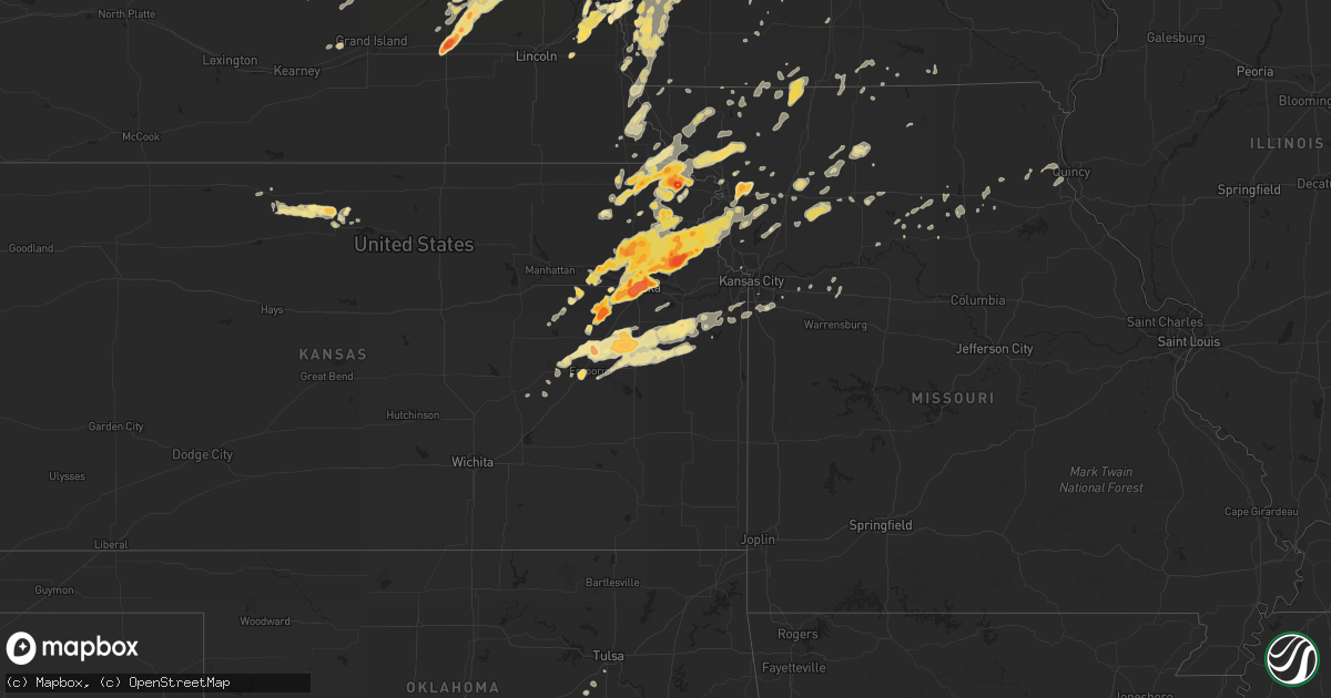
Hail Map in Kansas on May 21, 2011
Get this storm
May 21 map
$229
one time, instant access
Download today. No call, no setup
Keep the $229
Bought the map and want the full workflow? Apply the entire $229 to a subscription within 7 days. None of it is wasted.
Every map, not just this one
This buys you this map. Subscription and you get every map we run, in the markets you choose from a few cities to whole states to nationwide. Plus real-time alerts the moment a storm fires.
Contact data
Name, contact info, occupancy, even credit band for addresses in the footprint. You go from where it hit to who to call.
Become the source they trust
Unlimited branding weather history reports on demand. You already have the documented answer ready for the property owner, and you are the one who showed up with it.
Property data and RoofTrace estimates
Pull up any address you have got, its value and the exact code rules for that jurisdiction, straight from One Click Code. Then RoofTrace estimates the squares, pitch, and roof value, priced the way you price.
Storm reports in Kansas
Kansas
| Date | Description |
|---|---|
| 05/21/20116:58 PM CDT | A local report indicates 1.75 inch wind near ALMA |
| 05/21/20116:57 PM CDT | A local report indicates 1.75 inch wind near 3 NNE GRANTVILLE |
| 05/21/20116:57 PM CDT | A local report indicates a tornado near 4 N HIGHLAND |
| 05/21/20116:54 PM CDT | At us 40 and k4. |
| 05/21/20116:49 PM CDT | A local report indicates 1.00 inch wind near ST. MARYS |
| 05/21/20116:48 PM CDT | A local report indicates 1.75 inch wind near ST. MARYS |
| 05/21/20116:46 PM CDT | A local report indicates 1.75 inch wind near ST. MARYS |
| 05/21/20116:46 PM CDT | At 29th and meradin rd. |
| 05/21/20116:45 PM CDT | A local report indicates 1.75 inch wind near 6 N ROBINSON |
| 05/21/20116:45 PM CDT | A local report indicates 2.75 inch wind near HIGHLAND |
| 05/21/20116:42 PM CDT | A local report indicates 1.75 inch wind near 3 NE TOPEKA |
| 05/21/20116:41 PM CDT | At 33rd sw and stone st. |
| 05/21/20116:39 PM CDT | Damage at ballfields at 29th and croco and a 5th wheel over turned possible tornado |
| 05/21/20116:38 PM CDT | A local report indicates 1.50 inch wind near 2 SE EVEREST |
| 05/21/20116:35 PM CDT | A local report indicates 1.50 inch wind near 3 NE TOPEKA |
| 05/21/20116:34 PM CDT | A local report indicates 2.00 inch wind near 1 NW TOPEKA |
| 05/21/20116:33 PM CDT | A local report indicates 2.00 inch wind near 2 SW TOPEKA |
| 05/21/20116:29 PM CDT | A local report indicates 1.25 inch wind near 3 SW TOPEKA |
| 05/21/20116:27 PM CDT | Large tree limbs down 61st and wanamaker. |
| 05/21/20116:27 PM CDT | A local report indicates 1.25 inch wind near SW TOPEKA |
| 05/21/20116:27 PM CDT | A local report indicates 1.25 inch wind near MUSCOTAH |
| 05/21/20116:27 PM CDT | A local report indicates 1.75 inch wind near 3 SW TOPEKA |
| 05/21/20116:25 PM CDT | A local report indicates 1.00 inch wind near 3 SW TOPEKA |
| 05/21/20116:18 PM CDT | A local report indicates 1.00 inch wind near 1 E DENISON |
| 05/21/20116:18 PM CDT | Also observing a wall cloud in same location. |
| 05/21/20116:17 PM CDT | Drifts of quarter size hail and larger along side the road 1 mile southeast of harlan |
| 05/21/20116:16 PM CDT | Weak ef0 tornado damaged an outbuilding and snapped some trees near the washburn rural highschool. |
| 05/21/20116:06 PM CDT | A local report indicates 1.25 inch wind near HOYT |
| 05/21/20116:05 PM CDT | Frequent golf ball and occasionally larger hail. |
| 05/21/20116:00 PM CDT | A local report indicates 1.75 inch wind near 2 E DOVER |
| 05/21/20116:00 PM CDT | Near sw 27th street and sw washburn ave. Time estimated. |
| 05/21/20115:57 PM CDT | Measured 5 1/4 in hail |
| 05/21/20115:57 PM CDT | A local report indicates 1.50 inch wind near 5 ENE FAIRVIEW |
| 05/21/20115:57 PM CDT | A local report indicates 1.50 inch wind near CEDAR |
| 05/21/20115:53 PM CDT | A local report indicates 1.75 inch wind near DOVER |
| 05/21/20115:53 PM CDT | A local report indicates 1.00 inch wind near 2 E DOVER |
| 05/21/20115:50 PM CDT | A local report indicates 1.00 inch wind near 6 WNW TOPEKA |
| 05/21/20115:43 PM CDT | A local report indicates 1.75 inch wind near 2 S FAIRVIEW |
| 05/21/20115:40 PM CDT | A local report indicates 1.50 inch wind near 4 S WILLARD |
| 05/21/20115:37 PM CDT | A local report indicates 1.00 inch wind near 4 S WILLARD |
| 05/21/20115:35 PM CDT | Spotter reports quarter sized hail at i-70 and sw carlson rd. |
| 05/21/20115:35 PM CDT | A local report indicates 1.00 inch wind near SSW SABETHA |
| 05/21/20115:35 PM CDT | A local report indicates 1.25 inch wind near KIRWIN |
| 05/21/20115:34 PM CDT | A local report indicates 1.00 inch wind near 1 S ESKRIDGE |
| 05/21/20115:33 PM CDT | A local report indicates 1.75 inch wind near 4 SE ESKRIDGE |
| 05/21/20115:30 PM CDT | A local report indicates 2.50 inch wind near SE ESKRIDGE |
| 05/21/20115:29 PM CDT | A local report indicates 1.00 inch wind near 5 S KIRWIN |
| 05/21/20115:13 PM CDT | Relayed by wibw tv |
| 05/21/20115:13 PM CDT | Hail covering the ground |
| 05/21/201112:12 AM CDT | A local report indicates 1.00 inch wind near 7 ESE OTTAWA |
| 05/21/201112:05 AM CDT | A local report indicates 1.25 inch wind near 5 SE OTTAWA |
| 05/20/201111:36 PM CDT | Pea size to quarter size hail. |
| 05/20/201110:52 PM CDT | Relayed by emergency manager |
| 05/20/201110:43 PM CDT | Minor damage to several homes in quenemo. No injuries. One barn or garage destroyed. |
| 05/20/201110:41 PM CDT | Relayed by county em near the 59 and 56 junction |
| 05/20/201110:40 PM CDT | 60 mph wind gust from storm chaser relayed by em. |
| 05/20/201110:38 PM CDT | Relayed by em at the corner of hwy 56 and hwy 59 |
| 05/20/201110:36 PM CDT | Relayed by osage county em |
| 05/20/201110:26 PM CDT | A local report indicates 1.25 inch wind near CENTROPOLIS |
| 05/20/201110:15 PM CDT | Relayed by osage county em |
| 05/20/201110:15 PM CDT | A local report indicates 2.75 inch wind near OSAGE CITY |
| 05/20/201110:13 PM CDT | A local report indicates 1.00 inch wind near 5 NW LEAVENWORTH |
| 05/20/201110:10 PM CDT | A local report indicates 1.00 inch wind near 2 S OSAGE CITY |
| 05/20/201110:00 PM CDT | A local report indicates 1.75 inch wind near 2 W EASTON KS |
| 05/20/20119:48 PM CDT | A local report indicates 1.00 inch wind near LYNDON |
| 05/20/20119:43 PM CDT | 4 foot tree uprooted and damaged propane tank |
| 05/20/20119:38 PM CDT | A local report indicates 1.00 inch wind near 2 ESE OZAWKIE |
| 05/20/20119:33 PM CDT | 70 mph winds |
| 05/20/20119:15 PM CDT | A local report indicates 1.75 inch wind near NORTONVILLE |
| 05/20/20119:15 PM CDT | Reported by emergeny management |
| 05/20/20119:07 PM CDT | A local report indicates 1.00 inch wind near 8 NNE EMPORIA |
| 05/20/20119:00 PM CDT | A local report indicates 1.75 inch wind near 10 N EMPORIA |
| 05/20/20118:59 PM CDT | A local report indicates a tornado near 9 ENE EMPORIA |
| 05/20/20118:56 PM CDT | A local report indicates a tornado near 4 NE EMPORIA |
| 05/20/20118:51 PM CDT | A local report indicates a tornado near 1 NE EMPORIA |
| 05/20/20118:48 PM CDT | A local report indicates 1.75 inch wind near 1 NNE NORTONVILLE |
| 05/20/20118:46 PM CDT | A local report indicates 1.00 inch wind near 5 SSE BUSHONG |
| 05/20/20118:44 PM CDT | A local report indicates 1.25 inch wind near 1 N SILVER LAKE |
| 05/20/20118:42 PM CDT | A local report indicates 1.75 inch wind near 1 N NORTONVILLE |
| 05/20/20118:38 PM CDT | A local report indicates 1.75 inch wind near 1 NW EMPORIA |
| 05/20/20118:34 PM CDT | A local report indicates 1.00 inch wind near 4 ESE DUNLAP |
| 05/20/20118:34 PM CDT | A local report indicates 1.75 inch wind near 2 ESE MAYETTA |
| 05/20/20118:33 PM CDT | A local report indicates 1.00 inch wind near 5 NW LEAVENWORTH |
| 05/20/20118:30 PM CDT | At 118th and s-road. |
| 05/20/20118:30 PM CDT | At 134th and 75 hwy |
| 05/20/20118:29 PM CDT | Some stones were larger but size was unknown |
| 05/20/20118:28 PM CDT | A local report indicates 1.00 inch wind near 5 W AMERICUS |
| 05/20/20118:17 PM CDT | A local report indicates 1.00 inch wind near 2 W EASTON KS |
| 05/20/20118:10 PM CDT | A local report indicates 2.00 inch wind near 2 ESE OSKALOOSA |
| 05/20/20118:08 PM CDT | A local report indicates 2.75 inch wind near 4 NE OSKALOOSA |
| 05/20/20118:07 PM CDT | A local report indicates 1.75 inch wind near 4 N EASTON KS |
| 05/20/20118:05 PM CDT | A local report indicates 1.25 inch wind near 5 N MCLOUTH |
| 05/20/20118:04 PM CDT | A local report indicates 2.50 inch wind near 4 NE OSKALOOSA |
| 05/20/20118:01 PM CDT | A local report indicates 2.00 inch wind near 4 NE OSKALOOSA |
| 05/20/20118:00 PM CDT | A local report indicates 1.25 inch wind near E MAYETTA |
| 05/20/20117:57 PM CDT | A local report indicates 1.75 inch wind near 2 W EASTON KS |
| 05/20/20117:51 PM CDT | A local report indicates 2.00 inch wind near 6 WSW MAYETTA |
| 05/20/20117:50 PM CDT | A local report indicates 1.00 inch wind near COTTONWOOD FALLS |
| 05/20/20117:33 PM CDT | Lots of debris along roads. Large trees down. |
| 05/20/20117:33 PM CDT | Lots of debris along roads. Large trees down. |
| 05/20/20117:29 PM CDT | Tornado reported near lake perry. Lasted for about 3 minutes. |
| 05/20/20117:22 PM CDT | A local report indicates 1.25 inch wind near 1 NNE ST. MARYS |
| 05/20/20117:20 PM CDT | Damage at ballfields at 29th and croco and a 5th wheel over turned possible tornado |
| 05/20/20117:20 PM CDT | Water spout over lake perry |
| 05/20/20117:15 PM CDT | A local report indicates 1.00 inch wind near 2 SW OSKALOOSA |
| 05/20/20117:12 PM CDT | A local report indicates 1.00 inch wind near 1 W CAWKER CITY |
| 05/20/20117:10 PM CDT | A local report indicates 1.75 inch wind near 4 S OZAWKIE |
| 05/20/20117:08 PM CDT | A local report indicates 2.00 inch wind near 4 NNW PERRY |
| 05/20/20117:00 PM CDT | 21st and corco rd. |
| 05/20/20117:00 PM CDT | A local report indicates 1.75 inch wind near 3 S MERIDEN |
| 05/20/20117:00 PM CDT | A local report indicates 1.75 inch wind near TECUMSEH |
| 05/20/20117:00 PM CDT | *** 1 inj *** hail broke car windows at 6th and croco rd. One injury reported from the hail. |
All States Impacted by Hail Map on May 21, 2011
Cities Impacted by Hail Map on May 21, 2011
- Neola, IA
- Ada, OK
- Sasakwa, OK
- Stratford, OK
- Konawa, OK
- Byars, OK
- Revere, MN
- Lamberton, MN
- Hancock, MN
- Hartley, IA
- Primghar, IA
- Sanborn, IA
- Garvin, MN
- Cogswell, ND
- Forman, ND
- Schleswig, IA
- Ida Grove, IA
- Hopkins, MO
- Goldthwaite, TX
- Carson, IA
- Macedonia, IA
- Oakland, IA
- Hancock, IA
- Griswold, IA
- Henderson, IA
- Logan, IA
- Woodbine, IA
- Dunlap, IA
- Scotia, NE
- Greeley, NE
- Lidgerwood, ND
- Cayuga, ND
- Wakefield, NE
- Wayne, NE
- Pender, NE
- Thurston, NE
- Laurel, NE
- Emerson, NE
- Allen, NE
- Dixon, NE
- Concord, NE
- Maple Plain, MN
- Mound, MN
- Center, KY
- Horse Cave, KY
- Offutt Afb, NE
- Plattsmouth, NE
- Council Bluffs, IA
- Bellevue, NE
- McClelland, IA
- Zwolle, LA
- Many, LA
- Cameron, MO
- Osborn, MO
- Gallatin, TN
- Shreveport, LA
- Britt, IA
- Okolona, AR
- Modale, IA
- Mondamin, IA
- Missouri Valley, IA
- Winside, NE
- Evant, TX
- Buffalo, MN
- Loretto, MN
- Rockford, MN
- Royal, AR
- Bonnerdale, AR
- Bertram, TX
- Briggs, TX
- Lampasas, TX
- Madison, NE
- Humphrey, NE
- Louisville, NE
- Ashland, NE
- Murdock, NE
- Casey, IA
- Guthrie Center, IA
- Craig, MO
- Rulo, NE
- Hiawatha, KS
- Falls City, NE
- Purmela, TX
- Orange City, IA
- Stroud, OK
- Depew, OK
- Olaton, KY
- Knob Lick, KY
- Cave City, KY
- Glasgow, KY
- Oakland, NE
- Scribner, NE
- West Point, NE
- Gatesville, TX
- Sheldon, IA
- Papillion, NE
- Springfield, NE
- Hector, MN
- Fairfax, MN
- Panama, IA
- Earling, IA
- Dearborn, MO
- Easton, KS
- Walnut Grove, MN
- Alma, KS
- Downs, KS
- Riverton, IA
- Sidney, IA
- Hamburg, IA
- Kirwin, KS
- Cedar, KS
- Gaylord, KS
- Ashland, LA
- Castor, LA
- Omaha, NE
- La Vista, NE
- Sabetha, KS
- Alta Vista, KS
- Kidder, MO
- Gallatin, MO
- Winston, MO
- Altamont, MO
- Hamilton, MO
- Danvers, MN
- Appleton, MN
- Irwin, IA
- Kirkman, IA
- Lindsay, NE
- Percival, IA
- Amity, AR
- Emerson, AR
- Cherokee, TX
- Anoka, MN
- Andover, MN
- Wallingford, IA
- Graettinger, IA
- Mapleton, IA
- Sulphur, OK
- Jonesboro, TX
- Valley Mills, TX
- Morgan, MN
- Effingham, KS
- Horton, KS
- Everest, KS
- Lancaster, KS
- Muscotah, KS
- Bronson, TX
- Meadville, MO
- Roff, OK
- Malvern, AR
- Emporia, KS
- Strong City, KS
- Copperas Cove, TX
- Surprise, NE
- Ulysses, NE
- Rising City, NE
- Shelby, NE
- Osborne, KS
- Portis, KS
- Waverly, MN
- Montrose, MN
- Arkadelphia, AR
- Rock Port, MO
- Newcastle, NE
- Elk Point, SD
- Burbank, SD
- Vermillion, SD
- Montevideo, MN
- Benson, MN
- Troy, KS
- Jackson, MN
- Mount Holly, AR
- Stephens, AR
- White Cloud, KS
- Forest City, MO
- Highland, KS
- Powhattan, KS
- Fairview, KS
- Robinson, KS
- Morrill, KS
- Osage City, KS
- Greensburg, KY
- Edmonton, KY
- Higginsville, MO
- Hurley, SD
- Viborg, SD
- Reading, KS
- Lyndon, KS
- Waldo, AR
- Kimballton, IA
- Morris, MN
- Sherburn, MN
- Greenwood, LA
- Keithville, LA
- Bossier City, LA
- Hamel, MN
- Long Lake, MN
- Spring Park, MN
- Howard Lake, MN
- Cokato, MN
- Mountain Lake, MN
- Odin, MN
- Burnet, TX
- Florence, TX
- Brainerd, MN
- Magnolia, AR
- Taylor, AR
- Stratford, SD
- Davis, SD
- Centerville, SD
- Irene, SD
- Randolph, NE
- Bancroft, NE
- Rosalie, NE
- Walthill, NE
- Grant City, MO
- Mount Ayr, IA
- Kellerton, IA
- Lamoni, IA
- Martinsville, MO
- Hatfield, MO
- Sumner, IA
- Hartington, NE
- Park Falls, WI
- Phillips, WI
- Osceola, NE
- Platte City, MO
- Smithville, MO
- Mullin, TX
- Ringsted, IA
- Dunnell, MN
- Ceylon, MN
- Dolliver, IA
- Estherville, IA
- Underwood, IA
- Hope, AR
- Malvern, IA
- Brunswick, MO
- Skidmore, MO
- Cowgill, MO
- Polo, MO
- Braymer, MO
- Breckenridge, MO
- Kingston, MO
- McNeil, AR
- Rosston, AR
- Worthington, MN
- Lake Park, IA
- Round Lake, MN
- Harris, IA
- Oskaloosa, KS
- Hubbard, NE
- Kempner, TX
- Fort Hood, TX
- Beresford, SD
- Tolar, TX
- Granbury, TX
- Rison, AR
- Bethany, LA
- Volin, SD
- Melvern, KS
- Quenemo, KS
- Oregon, MO
- Rosendale, MO
- Bolckow, MO
- Fillmore, MO
- Groton, SD
- Ferney, SD
- Conde, SD
- El Dorado, AR
- North Branch, MN
- Stacy, MN
- Oneida, KS
- Boys Town, NE
- Tow, TX
- Bluffton, TX
- San Saba, TX
- Verdigre, NE
- Lometa, TX
- Hamilton, TX
- Crescent, IA
- Leawood, KS
- Overland Park, KS
- Richland Springs, TX
- Donaldson, AR
- Veblen, SD
- Osage, IA
- Sheldon, WI
- Chidester, AR
- Fenton, IA
- Lone Rock, IA
- Glade, KS
- Lester Prairie, MN
- Silver Lake, MN
- Winsted, MN
- Mayer, MN
- New Germany, MN
- Hutchinson, MN
- De Witt, MO
- Carrollton, MO
- Bancroft, IA
- Burt, IA
- Williamsburg, KS
- Pomona, KS
- Wakonda, SD
- Edgerton, MO
- Gower, MO
- Peru, NE
- Nebraska City, NE
- Hoyt, KS
- Meriden, KS
- Denison, KS
- Creston, NE
- Columbus, NE
- Leigh, NE
- Sparkman, AR
- Carthage, AR
- Leola, AR
- Maryville, MO
- Maitland, MO
- Mound City, MO
- Fairfax, MO
- Burlington Junction, MO
- Moorhead, IA
- Paxico, KS
- Maple Hill, KS
- Cosby, MO
- Easton, MO
- Stewartsville, MO
- Clarksdale, MO
- Saint Joseph, MO
- Ottawa, KS
- Lebo, KS
- Eskridge, KS
- Elmo, MO
- Westboro, MO
- Glenwood, IA
- Castle, OK
- Bristow, OK
- Glen Rose, TX
- Hico, TX
- Stephenville, TX
- Bluff Dale, TX
- Dublin, TX
- Portsmouth, IA
- Cottonwood Falls, KS
- Colton, SD
- Gresham, NE
- David City, NE
- Waco, NE
- York, NE
- Karnack, TX
- Belcher, LA
- Benton, LA
- Vivian, LA
- Hosston, LA
- Plain Dealing, LA
- Gilliam, LA
- Jefferson, TX
- Cotton Valley, LA
- Oil City, LA
- Mooringsport, LA
- Herman, MN
- Barrett, MN
- Hoffman, MN
- Delia, KS
- Holton, KS
- Mayetta, KS
- Tecumseh, KS
- Rossville, KS
- Rushville, MO
- Winchester, KS
- Harveyville, KS
- Grantville, KS
- Ozawkie, KS
- Leavenworth, KS
- Weston, MO
- Auburn, KS
- McLouth, KS
- Saint Marys, KS
- Silver Lake, KS
- Faucett, MO
- Cummings, KS
- Topeka, KS
- Nortonville, KS
- Atchison, KS
- De Kalb, MO
- Valley Falls, KS
- Shubert, NE
- Stella, NE
- Auburn, NE
- Nemaha, NE
- Brownville, NE
- Rush City, MN
- Harris, MN
- Little Falls, MN
- Salisbury, MO
- South Bend, NE
- Gretna, NE
- Maysville, MO
- Excello, MO
- Jacksonville, MO
- Lucan, MN
- Gwinner, ND
- Stuart, IA
- Butterfield, MN
- Trimont, MN
- Alpha, MN
- Jessieville, AR
- Allen, KS
- Glencoe, MN
- Lonsdale, AR
- Benton, AR
- Hot Springs Village, AR
- Hot Springs National Park, AR
- Chillicothe, MO
- Hale, MO
- Jefferson, AR
- Sherrill, AR
- White Hall, AR
- Bruno, NE
- Minneapolis, MN
- Cresson, TX
- Mountain Pine, AR
- Palmyra, MO
- Taylor, MO
- Wood River, NE
- Americus, KS
- Admire, KS
- Osakis, MN
- Scandia, MN
- Macomb, IL
- Doddridge, AR
- Forest City, IA
- Speer, IL
- Overbrook, KS
- Lawrence, KS
- Corning, KS
- Goff, KS
- Evansville, MN
- Battle Lake, MN
- Clitherall, MN
- Kingsland, AR
- Fordyce, AR
- Maple Grove, MN
- Wayzata, MN
- Lake Crystal, MN
- Colchester, IL
- Plymouth, IL
- Stanton, NE
- Windom, MN
- Glenwood, AR
- Norman, AR
- Heron Lake, MN
- Agency, MO
- Perry, KS
- Fort Leavenworth, KS
- Saint Paul, MN
- Utica, NE
- Bellwood, NE
- Stromsburg, NE
- Brainard, NE
- Benedict, NE
- Redding, IA
- Wells, MN
- Alden, MN
- Lakefield, MN
- Trenton, MO
- Penfield, IL
- Faulkton, SD
- Hardwick, MN
- Jasper, MN
- Springhill, LA
- Sarepta, LA
- Shongaloo, LA
- Elmwood, NE
- Turton, SD
- Dwight, KS
- Honey Creek, IA
- Smiths Grove, KY
- Centerville, IA
- Osseo, MN
- Worthing, SD
- Canton, SD
- South Haven, MN
- Kellyville, OK
- Lu Verne, IA
- Corwith, IA
- Prescott, AR
- Buckner, AR
- Stamps, AR
- Garland City, AR
- Emmet, AR
- Lewisville, AR
- Norfolk, NE
- Shenandoah, IA
- Coin, IA
- Northboro, IA
- Vassar, KS
- Oakland, KY
- Wetmore, KS
- Jamesport, MO
- Stirum, ND
- Minden, IA
- Truman, MN
- Murfreesboro, AR
- Bismarck, AR
- Pearcy, AR
- Delight, AR
- Kirby, AR
- Guilford, MO
- Savannah, MO
- Rea, MO
- Kathryn, ND
- Hoskins, NE
- Mammoth Cave, KY
- Llano, TX
- Becker, MN
- Pine Bluff, AR
- Craig, NE
- Caddo Gap, AR
- Broaddus, TX
- Pineland, TX
- Castana, IA
- Kansas City, MO
- Whiting, KS
- Netawaka, KS
- Shelby, IA
- Mendon, MO
- Lyons, NE
- Lennox, SD
- Lake View, IA
- Callao, MO
- Long Prairie, MN
- Dassel, MN
- Cedar, MN
- Imogene, IA
- Sheridan, AR
- Coleridge, NE
- Keytesville, MO
- Milroy, MN
- Prattsville, AR
- Randolph, IA
- Hastings, IA
- Silver City, IA
- Tabor, IA
- Burnsville, MN
- Ruthven, IA
- Emmetsburg, IA
- Ayrshire, IA
- Comfrey, MN
- Bingham Lake, MN
- Jeffers, MN
- Welcome, MN
- Armstrong, IA
- Springfield, MN
- Sanborn, MN
- Bartlett, NE
- Plattsburg, MO
- Langley, AR
- Corydon, IA
- Buffalo Lake, MN
- Stewart, MN
- Hartford, KY
- Dundee, KY
- Camden, AR
- Echo, MN
- Livermore, IA
- Jesup, IA
- Barnard, MO
- Farmington, MN
- Lakeville, MN
- Elbow Lake, MN
- Pilger, NE
- Amity, MO
- Coushatta, LA
- Delano, MN
- Watertown, MN
- Okabena, MN
- Emerson, IA
- Lees Summit, MO
- Glenwood, MN
- Avoca, IA
- Clarence, MO
- Saint Paul, NE
- Platte Center, NE
- Lathrop, MO
- Holt, MO
- Maynard, MN
- Wynot, NE
- Altheimer, AR
- Corning, IA
- Lenox, IA
- Buffalo Center, IA
- Paden, OK
- Browerville, MN
- Medford, WI
- Cedar Creek, NE
- San Augustine, TX
- Treynor, IA
- Decorah, IA
- Loup City, NE
- Hudson, SD
- Alcester, SD
- Moulton, IA
- Onawa, IA
- Elba, NE
- Lake Wilson, MN
- Laredo, MO
- Galt, MO
- Charleston, MS
- Cascilla, MS
- Wellsville, KS
- Princeton, KS
- Waverly, KS
- Burlingame, KS
- Council Grove, KS
- Rantoul, KS
- Neosho Rapids, KS
- Scranton, KS
- Baldwin City, KS
- Clarkson, NE
- Correll, MN
- Amazonia, MO
- Chula, MO
- Humphreys, MO
- Britton, SD
- Clifton, TX
- Horse Branch, KY
- Fordsville, KY
- Stilwell, KS
- Belton, MO
- Manilla, IA
- Vail, IA
- Orchard, NE
- Salem, NE
- Brownton, MN
- Fulda, MN
- Spirit Lake, IA
- Gurdon, AR
- England, AR
- Rochelle, TX
- Marceline, MO
- Carlton, TX
- Wesley, IA
- Granville, IA
- Alton, IA
- Fordyce, NE
- Trimble, MO
- Hemphill, TX
- Huntington, TX
- Concordia, MO
- Hospers, IA
- Harrisburg, SD
- Milam, TX
- Fouke, AR
- Beggs, OK
- Sapulpa, OK
- Weatherford, TX
- Barnum, IA
- Manson, IA
- Creston, IA
- Starbuck, MN
- Allerton, IA
- Parnell, MO
- Westboro, WI
- Grandview, MO
- Gayville, SD
- Osceola, IA
- Lisbon, ND
- Minden, LA
- Circleville, KS
- Maywood, MO
- La Grange, MO
- Seymour, IA
- Milnor, ND
- Grapevine, AR
- Winter, WI
- Ojibwa, WI
- Union Star, MO
- Sisseton, SD
- Tekamah, NE
- Henning, MN
- Ottertail, MN
- Etoile, TX
- Quincy, IL
- Ashton, NE
- North Loup, NE
- West Bend, IA
- Pottsville, TX
- Denton, KS
- Bendena, KS
- White Heath, IL
- Murdock, MN
- Shawnee, OK
- Prague, OK
- New Cambria, MO
- Napoleon, MO
- Bates City, MO
- Oak Grove, MO
- Buchanan Dam, TX
- Hawkins, WI
- Glen Flora, WI
- Bradley, AR
- Cawker City, KS
- Mayview, MO
- Georgetown, TX
- Winnebago, NE
- Reliance, SD
- Wyoming, IL
- Phillipsburg, KS
- Prairie View, KS
- Willisville, AR
- Orient, IA
- Mercer, MO
- Spring Hill, KS
- Bucyrus, KS
- Olathe, KS
- Blencoe, IA
- Roscoe, TX
- Fontanelle, IA
- Mitchell, SD
- Annandale, MN
- Mineola, IA
- Lower Brule, SD
- Cottonwood, MN
- Saint Michael, MN
- Dayton, MN
- Champlin, MN
- Dannebrog, NE
- Henry, IL
- Sparland, IL
- Grain Valley, MO
- Blue Springs, MO
- Lakota, IA
- Swea City, IA
- Bluff City, AR
- Gardner, KS
- Edgerton, KS
- Hardyville, KY
- Haughton, LA
- Beemer, NE
- Cedar Rapids, NE
- Wolbach, NE
- Fort Thompson, SD
- Rogers, MN
- Rothville, MO
- Havana, ND
- Doland, SD
- Hornbeck, LA
- Fonda, IA
- Bertha, MN
- Staples, MN
- Clarissa, MN
- Ericson, NE
- Humboldt, NE
- Wheaton, MN
- Thompson, IA
- Holly Grove, AR
- Elm Grove, LA
- Paola, KS
- Powersville, MO
- Pierpont, SD
- Magnolia, KY
- Cedar Point, KS
- Aldrich, MN
- Anabel, MO
- Fitzhugh, OK
- Fittstown, OK
- Stonewall, OK
- Green City, MO
- Garner, IA
- Sturgeon Lake, MN
- Oakes, ND
- Bradley, SD
- Tyler, MN
- Ruthton, MN
- Oto, IA
- Farwell, NE
- Elk Horn, IA
- Exeland, WI
- Madison, MO
- Loraine, TX
- Zephyr, TX
- Star, TX
- Melvin, IA
- Greenfield, IA
- Wyoming, MN
- Rutland, ND
- Ocheyedan, IA
- Homer, NE
- Shelton, NE
- Big Lake, MN
- Soldier, IA
- Pisgah, IA
- Harlan, IA
- Myakka City, FL
- Slayton, MN
- Pickering, MO
- Mabelvale, AR
- Bauxite, AR
- Carroll, IA
- Verdon, NE
- Carroll, NE
- Ravenwood, MO
- Tomahawk, WI
- Huntsville, MO
- Edgerton, MN
- Ivan, AR
- Redfield, AR
- Eagle Bend, MN
- Albany, MO
- Denver, MO
- New Century, KS
- Eudora, KS
- Early, IA
- Schaller, IA
- Stanberry, MO
- Chandler, MN
- Dickens, IA
- Jolley, IA
- Rockwell City, IA
- Carthage, TX
- Miller, SD
- Ute, IA
- Charter Oak, IA
- Denison, IA
- Ricketts, IA
- Dow City, IA
- Monroe, NE
- Liberty, IL
- Bend, TX
- Liberty Hill, TX
- Ludlow, MO
- Mooresville, MO
- Marthaville, LA
- Pipestone, MN
- Durham, MO
- Rice, MN
- Fort Calhoun, NE
- Walnut, IA
- Farragut, IA
- Shelbyville, MO
- Saint Charles, IA
- Spalding, NE
- Forest Lake, MN
- Belvue, KS
- King City, MO
- Seneca, KS
- Helena, MO
- Tarkio, MO
- Dewitt, IL
- Ord, NE
- Thurman, IA
- Arthur, IA
- Sheridan, MO
- Blockton, IA
- Tyndall, SD
- Scotland, SD
- Storden, MN
- Nicollet, MN
- Denver, IA
- Meridian, TX
- Cranfills Gap, TX
- Jarrell, TX
- Stonewall, LA
- Bethel, MO
- Emden, MO
- Philadelphia, MO
- Tucker, AR
- Cromwell, IA
- Florien, LA
- Odessa, MO
- Hanover, MN
- Randall, MN
- Schuyler, NE
- Waite Park, MN
- Lawson, MO
- Munfordville, KY
- Ewing, MO
- Jackson, NE
- Tulsa, OK
- Pacific Junction, IA
- Lineville, IA
- Davis City, IA
- Leon, IA
- Cainsville, MO
- Maple Lake, MN
- Bethel, MN
- Franklin, MN
- Sioux City, IA
- Bedford, IA


