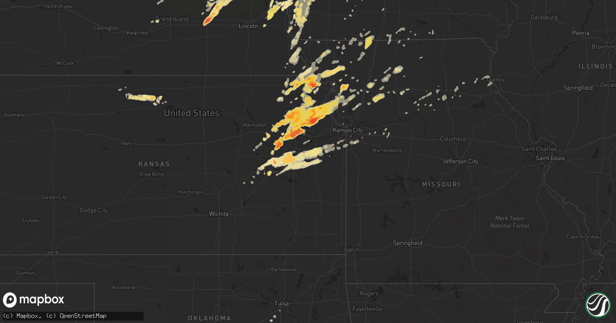
Hail Map in Iowa on May 21, 2011
Get this storm
May 21 map
$229
one time, instant access
Download today. No call, no setup
Keep the $229
Bought the map and want the full workflow? Apply the entire $229 to a subscription within 7 days. None of it is wasted.
Every map, not just this one
This buys you this map. Subscription and you get every map we run, in the markets you choose from a few cities to whole states to nationwide. Plus real-time alerts the moment a storm fires.
Contact data
Name, contact info, occupancy, even credit band for addresses in the footprint. You go from where it hit to who to call.
Become the source they trust
Unlimited branding weather history reports on demand. You already have the documented answer ready for the property owner, and you are the one who showed up with it.
Property data and RoofTrace estimates
Pull up any address you have got, its value and the exact code rules for that jurisdiction, straight from One Click Code. Then RoofTrace estimates the squares, pitch, and roof value, priced the way you price.
Storm reports in Iowa
Iowa
| Date | Description |
|---|---|
| 05/21/20116:55 PM CDT | Hail up to quarter size |
| 05/21/20116:03 PM CDT | Quarter size hail covering the ground... |
| 05/20/201110:19 PM CDT | Correction to report for same location at 836 pm. There were no reports for that location at 836 pm. |
| 05/20/201110:15 PM CDT | Estimated 60 mph wind with minor tree damage. Skirting off base of mobile home. |
| 05/20/20119:48 PM CDT | Pea sized hail as well. |
| 05/20/20119:41 PM CDT | Public report of damage to an outbuilding. Windows blown out. Relayed by polk co sheriffs dept. |
| 05/20/20119:41 PM CDT | United community school. Kcci schoolnet. |
| 05/20/20119:05 PM CDT | Power poles down. |
| 05/20/20118:53 PM CDT | A local report indicates 60 MPH wind near LAMONI AIRPORT |
| 05/20/20118:40 PM CDT | Near target in east council bluffs. |
| 05/20/20118:36 PM CDT | A local report indicates 60 MPH wind near SW OSKALOOSA |
| 05/20/20118:36 PM CDT | A local report indicates 1.00 inch wind near S GUTHRIE CENTER |
| 05/20/20118:27 PM CDT | A local report indicates 1.00 inch wind near 3 S DEFIANCE |
| 05/20/20118:18 PM CDT | A local report indicates 1.75 inch wind near LOGAN |
| 05/20/20118:05 PM CDT | Non rotating wall cloud moving overhead at 810 pm. |
| 05/20/20117:52 PM CDT | A local report indicates 1.50 inch wind near ESTHERVILLE AIRPORT |
| 05/20/20117:42 PM CDT | A local report indicates 2.00 inch wind near 5 E WALLINGFORD |
| 05/20/20117:38 PM CDT | A local report indicates 1.75 inch wind near WALLINGFORD |
| 05/20/20117:16 PM CDT | This was from saturday may 21 |
All States Impacted by Hail Map on May 21, 2011
Cities Impacted by Hail Map on May 21, 2011
- Neola, IA
- Ada, OK
- Sasakwa, OK
- Stratford, OK
- Konawa, OK
- Byars, OK
- Revere, MN
- Lamberton, MN
- Hancock, MN
- Hartley, IA
- Primghar, IA
- Sanborn, IA
- Garvin, MN
- Cogswell, ND
- Forman, ND
- Schleswig, IA
- Ida Grove, IA
- Hopkins, MO
- Goldthwaite, TX
- Carson, IA
- Macedonia, IA
- Oakland, IA
- Hancock, IA
- Griswold, IA
- Henderson, IA
- Logan, IA
- Woodbine, IA
- Dunlap, IA
- Scotia, NE
- Greeley, NE
- Lidgerwood, ND
- Cayuga, ND
- Wakefield, NE
- Wayne, NE
- Pender, NE
- Thurston, NE
- Laurel, NE
- Emerson, NE
- Allen, NE
- Dixon, NE
- Concord, NE
- Maple Plain, MN
- Mound, MN
- Center, KY
- Horse Cave, KY
- Offutt Afb, NE
- Plattsmouth, NE
- Council Bluffs, IA
- Bellevue, NE
- McClelland, IA
- Zwolle, LA
- Many, LA
- Cameron, MO
- Osborn, MO
- Gallatin, TN
- Shreveport, LA
- Britt, IA
- Okolona, AR
- Modale, IA
- Mondamin, IA
- Missouri Valley, IA
- Winside, NE
- Evant, TX
- Buffalo, MN
- Loretto, MN
- Rockford, MN
- Royal, AR
- Bonnerdale, AR
- Bertram, TX
- Briggs, TX
- Lampasas, TX
- Madison, NE
- Humphrey, NE
- Louisville, NE
- Ashland, NE
- Murdock, NE
- Casey, IA
- Guthrie Center, IA
- Craig, MO
- Rulo, NE
- Hiawatha, KS
- Falls City, NE
- Purmela, TX
- Orange City, IA
- Stroud, OK
- Depew, OK
- Olaton, KY
- Knob Lick, KY
- Cave City, KY
- Glasgow, KY
- Oakland, NE
- Scribner, NE
- West Point, NE
- Gatesville, TX
- Sheldon, IA
- Papillion, NE
- Springfield, NE
- Hector, MN
- Fairfax, MN
- Panama, IA
- Earling, IA
- Dearborn, MO
- Easton, KS
- Walnut Grove, MN
- Alma, KS
- Downs, KS
- Riverton, IA
- Sidney, IA
- Hamburg, IA
- Kirwin, KS
- Cedar, KS
- Gaylord, KS
- Ashland, LA
- Castor, LA
- Omaha, NE
- La Vista, NE
- Sabetha, KS
- Alta Vista, KS
- Kidder, MO
- Gallatin, MO
- Winston, MO
- Altamont, MO
- Hamilton, MO
- Danvers, MN
- Appleton, MN
- Irwin, IA
- Kirkman, IA
- Lindsay, NE
- Percival, IA
- Amity, AR
- Emerson, AR
- Cherokee, TX
- Anoka, MN
- Andover, MN
- Wallingford, IA
- Graettinger, IA
- Mapleton, IA
- Sulphur, OK
- Jonesboro, TX
- Valley Mills, TX
- Morgan, MN
- Effingham, KS
- Horton, KS
- Everest, KS
- Lancaster, KS
- Muscotah, KS
- Bronson, TX
- Meadville, MO
- Roff, OK
- Malvern, AR
- Emporia, KS
- Strong City, KS
- Copperas Cove, TX
- Surprise, NE
- Ulysses, NE
- Rising City, NE
- Shelby, NE
- Osborne, KS
- Portis, KS
- Waverly, MN
- Montrose, MN
- Arkadelphia, AR
- Rock Port, MO
- Newcastle, NE
- Elk Point, SD
- Burbank, SD
- Vermillion, SD
- Montevideo, MN
- Benson, MN
- Troy, KS
- Jackson, MN
- Mount Holly, AR
- Stephens, AR
- White Cloud, KS
- Forest City, MO
- Highland, KS
- Powhattan, KS
- Fairview, KS
- Robinson, KS
- Morrill, KS
- Osage City, KS
- Greensburg, KY
- Edmonton, KY
- Higginsville, MO
- Hurley, SD
- Viborg, SD
- Reading, KS
- Lyndon, KS
- Waldo, AR
- Kimballton, IA
- Morris, MN
- Sherburn, MN
- Greenwood, LA
- Keithville, LA
- Bossier City, LA
- Hamel, MN
- Long Lake, MN
- Spring Park, MN
- Howard Lake, MN
- Cokato, MN
- Mountain Lake, MN
- Odin, MN
- Burnet, TX
- Florence, TX
- Brainerd, MN
- Magnolia, AR
- Taylor, AR
- Stratford, SD
- Davis, SD
- Centerville, SD
- Irene, SD
- Randolph, NE
- Bancroft, NE
- Rosalie, NE
- Walthill, NE
- Grant City, MO
- Mount Ayr, IA
- Kellerton, IA
- Lamoni, IA
- Martinsville, MO
- Hatfield, MO
- Sumner, IA
- Hartington, NE
- Park Falls, WI
- Phillips, WI
- Osceola, NE
- Platte City, MO
- Smithville, MO
- Mullin, TX
- Ringsted, IA
- Dunnell, MN
- Ceylon, MN
- Dolliver, IA
- Estherville, IA
- Underwood, IA
- Hope, AR
- Malvern, IA
- Brunswick, MO
- Skidmore, MO
- Cowgill, MO
- Polo, MO
- Braymer, MO
- Breckenridge, MO
- Kingston, MO
- McNeil, AR
- Rosston, AR
- Worthington, MN
- Lake Park, IA
- Round Lake, MN
- Harris, IA
- Oskaloosa, KS
- Hubbard, NE
- Kempner, TX
- Fort Hood, TX
- Beresford, SD
- Tolar, TX
- Granbury, TX
- Rison, AR
- Bethany, LA
- Volin, SD
- Melvern, KS
- Quenemo, KS
- Oregon, MO
- Rosendale, MO
- Bolckow, MO
- Fillmore, MO
- Groton, SD
- Ferney, SD
- Conde, SD
- El Dorado, AR
- North Branch, MN
- Stacy, MN
- Oneida, KS
- Boys Town, NE
- Tow, TX
- Bluffton, TX
- San Saba, TX
- Verdigre, NE
- Lometa, TX
- Hamilton, TX
- Crescent, IA
- Leawood, KS
- Overland Park, KS
- Richland Springs, TX
- Donaldson, AR
- Veblen, SD
- Osage, IA
- Sheldon, WI
- Chidester, AR
- Fenton, IA
- Lone Rock, IA
- Glade, KS
- Lester Prairie, MN
- Silver Lake, MN
- Winsted, MN
- Mayer, MN
- New Germany, MN
- Hutchinson, MN
- De Witt, MO
- Carrollton, MO
- Bancroft, IA
- Burt, IA
- Williamsburg, KS
- Pomona, KS
- Wakonda, SD
- Edgerton, MO
- Gower, MO
- Peru, NE
- Nebraska City, NE
- Hoyt, KS
- Meriden, KS
- Denison, KS
- Creston, NE
- Columbus, NE
- Leigh, NE
- Sparkman, AR
- Carthage, AR
- Leola, AR
- Maryville, MO
- Maitland, MO
- Mound City, MO
- Fairfax, MO
- Burlington Junction, MO
- Moorhead, IA
- Paxico, KS
- Maple Hill, KS
- Cosby, MO
- Easton, MO
- Stewartsville, MO
- Clarksdale, MO
- Saint Joseph, MO
- Ottawa, KS
- Lebo, KS
- Eskridge, KS
- Elmo, MO
- Westboro, MO
- Glenwood, IA
- Castle, OK
- Bristow, OK
- Glen Rose, TX
- Hico, TX
- Stephenville, TX
- Bluff Dale, TX
- Dublin, TX
- Portsmouth, IA
- Cottonwood Falls, KS
- Colton, SD
- Gresham, NE
- David City, NE
- Waco, NE
- York, NE
- Karnack, TX
- Belcher, LA
- Benton, LA
- Vivian, LA
- Hosston, LA
- Plain Dealing, LA
- Gilliam, LA
- Jefferson, TX
- Cotton Valley, LA
- Oil City, LA
- Mooringsport, LA
- Herman, MN
- Barrett, MN
- Hoffman, MN
- Delia, KS
- Holton, KS
- Mayetta, KS
- Tecumseh, KS
- Rossville, KS
- Rushville, MO
- Winchester, KS
- Harveyville, KS
- Grantville, KS
- Ozawkie, KS
- Leavenworth, KS
- Weston, MO
- Auburn, KS
- McLouth, KS
- Saint Marys, KS
- Silver Lake, KS
- Faucett, MO
- Cummings, KS
- Topeka, KS
- Nortonville, KS
- Atchison, KS
- De Kalb, MO
- Valley Falls, KS
- Shubert, NE
- Stella, NE
- Auburn, NE
- Nemaha, NE
- Brownville, NE
- Rush City, MN
- Harris, MN
- Little Falls, MN
- Salisbury, MO
- South Bend, NE
- Gretna, NE
- Maysville, MO
- Excello, MO
- Jacksonville, MO
- Lucan, MN
- Gwinner, ND
- Stuart, IA
- Butterfield, MN
- Trimont, MN
- Alpha, MN
- Jessieville, AR
- Allen, KS
- Glencoe, MN
- Lonsdale, AR
- Benton, AR
- Hot Springs Village, AR
- Hot Springs National Park, AR
- Chillicothe, MO
- Hale, MO
- Jefferson, AR
- Sherrill, AR
- White Hall, AR
- Bruno, NE
- Minneapolis, MN
- Cresson, TX
- Mountain Pine, AR
- Palmyra, MO
- Taylor, MO
- Wood River, NE
- Americus, KS
- Admire, KS
- Osakis, MN
- Scandia, MN
- Macomb, IL
- Doddridge, AR
- Forest City, IA
- Speer, IL
- Overbrook, KS
- Lawrence, KS
- Corning, KS
- Goff, KS
- Evansville, MN
- Battle Lake, MN
- Clitherall, MN
- Kingsland, AR
- Fordyce, AR
- Maple Grove, MN
- Wayzata, MN
- Lake Crystal, MN
- Colchester, IL
- Plymouth, IL
- Stanton, NE
- Windom, MN
- Glenwood, AR
- Norman, AR
- Heron Lake, MN
- Agency, MO
- Perry, KS
- Fort Leavenworth, KS
- Saint Paul, MN
- Utica, NE
- Bellwood, NE
- Stromsburg, NE
- Brainard, NE
- Benedict, NE
- Redding, IA
- Wells, MN
- Alden, MN
- Lakefield, MN
- Trenton, MO
- Penfield, IL
- Faulkton, SD
- Hardwick, MN
- Jasper, MN
- Springhill, LA
- Sarepta, LA
- Shongaloo, LA
- Elmwood, NE
- Turton, SD
- Dwight, KS
- Honey Creek, IA
- Smiths Grove, KY
- Centerville, IA
- Osseo, MN
- Worthing, SD
- Canton, SD
- South Haven, MN
- Kellyville, OK
- Lu Verne, IA
- Corwith, IA
- Prescott, AR
- Buckner, AR
- Stamps, AR
- Garland City, AR
- Emmet, AR
- Lewisville, AR
- Norfolk, NE
- Shenandoah, IA
- Coin, IA
- Northboro, IA
- Vassar, KS
- Oakland, KY
- Wetmore, KS
- Jamesport, MO
- Stirum, ND
- Minden, IA
- Truman, MN
- Murfreesboro, AR
- Bismarck, AR
- Pearcy, AR
- Delight, AR
- Kirby, AR
- Guilford, MO
- Savannah, MO
- Rea, MO
- Kathryn, ND
- Hoskins, NE
- Mammoth Cave, KY
- Llano, TX
- Becker, MN
- Pine Bluff, AR
- Craig, NE
- Caddo Gap, AR
- Broaddus, TX
- Pineland, TX
- Castana, IA
- Kansas City, MO
- Whiting, KS
- Netawaka, KS
- Shelby, IA
- Mendon, MO
- Lyons, NE
- Lennox, SD
- Lake View, IA
- Callao, MO
- Long Prairie, MN
- Dassel, MN
- Cedar, MN
- Imogene, IA
- Sheridan, AR
- Coleridge, NE
- Keytesville, MO
- Milroy, MN
- Prattsville, AR
- Randolph, IA
- Hastings, IA
- Silver City, IA
- Tabor, IA
- Burnsville, MN
- Ruthven, IA
- Emmetsburg, IA
- Ayrshire, IA
- Comfrey, MN
- Bingham Lake, MN
- Jeffers, MN
- Welcome, MN
- Armstrong, IA
- Springfield, MN
- Sanborn, MN
- Bartlett, NE
- Plattsburg, MO
- Langley, AR
- Corydon, IA
- Buffalo Lake, MN
- Stewart, MN
- Hartford, KY
- Dundee, KY
- Camden, AR
- Echo, MN
- Livermore, IA
- Jesup, IA
- Barnard, MO
- Farmington, MN
- Lakeville, MN
- Elbow Lake, MN
- Pilger, NE
- Amity, MO
- Coushatta, LA
- Delano, MN
- Watertown, MN
- Okabena, MN
- Emerson, IA
- Lees Summit, MO
- Glenwood, MN
- Avoca, IA
- Clarence, MO
- Saint Paul, NE
- Platte Center, NE
- Lathrop, MO
- Holt, MO
- Maynard, MN
- Wynot, NE
- Altheimer, AR
- Corning, IA
- Lenox, IA
- Buffalo Center, IA
- Paden, OK
- Browerville, MN
- Medford, WI
- Cedar Creek, NE
- San Augustine, TX
- Treynor, IA
- Decorah, IA
- Loup City, NE
- Hudson, SD
- Alcester, SD
- Moulton, IA
- Onawa, IA
- Elba, NE
- Lake Wilson, MN
- Laredo, MO
- Galt, MO
- Charleston, MS
- Cascilla, MS
- Wellsville, KS
- Princeton, KS
- Waverly, KS
- Burlingame, KS
- Council Grove, KS
- Rantoul, KS
- Neosho Rapids, KS
- Scranton, KS
- Baldwin City, KS
- Clarkson, NE
- Correll, MN
- Amazonia, MO
- Chula, MO
- Humphreys, MO
- Britton, SD
- Clifton, TX
- Horse Branch, KY
- Fordsville, KY
- Stilwell, KS
- Belton, MO
- Manilla, IA
- Vail, IA
- Orchard, NE
- Salem, NE
- Brownton, MN
- Fulda, MN
- Spirit Lake, IA
- Gurdon, AR
- England, AR
- Rochelle, TX
- Marceline, MO
- Carlton, TX
- Wesley, IA
- Granville, IA
- Alton, IA
- Fordyce, NE
- Trimble, MO
- Hemphill, TX
- Huntington, TX
- Concordia, MO
- Hospers, IA
- Harrisburg, SD
- Milam, TX
- Fouke, AR
- Beggs, OK
- Sapulpa, OK
- Weatherford, TX
- Barnum, IA
- Manson, IA
- Creston, IA
- Starbuck, MN
- Allerton, IA
- Parnell, MO
- Westboro, WI
- Grandview, MO
- Gayville, SD
- Osceola, IA
- Lisbon, ND
- Minden, LA
- Circleville, KS
- Maywood, MO
- La Grange, MO
- Seymour, IA
- Milnor, ND
- Grapevine, AR
- Winter, WI
- Ojibwa, WI
- Union Star, MO
- Sisseton, SD
- Tekamah, NE
- Henning, MN
- Ottertail, MN
- Etoile, TX
- Quincy, IL
- Ashton, NE
- North Loup, NE
- West Bend, IA
- Pottsville, TX
- Denton, KS
- Bendena, KS
- White Heath, IL
- Murdock, MN
- Shawnee, OK
- Prague, OK
- New Cambria, MO
- Napoleon, MO
- Bates City, MO
- Oak Grove, MO
- Buchanan Dam, TX
- Hawkins, WI
- Glen Flora, WI
- Bradley, AR
- Cawker City, KS
- Mayview, MO
- Georgetown, TX
- Winnebago, NE
- Reliance, SD
- Wyoming, IL
- Phillipsburg, KS
- Prairie View, KS
- Willisville, AR
- Orient, IA
- Mercer, MO
- Spring Hill, KS
- Bucyrus, KS
- Olathe, KS
- Blencoe, IA
- Roscoe, TX
- Fontanelle, IA
- Mitchell, SD
- Annandale, MN
- Mineola, IA
- Lower Brule, SD
- Cottonwood, MN
- Saint Michael, MN
- Dayton, MN
- Champlin, MN
- Dannebrog, NE
- Henry, IL
- Sparland, IL
- Grain Valley, MO
- Blue Springs, MO
- Lakota, IA
- Swea City, IA
- Bluff City, AR
- Gardner, KS
- Edgerton, KS
- Hardyville, KY
- Haughton, LA
- Beemer, NE
- Cedar Rapids, NE
- Wolbach, NE
- Fort Thompson, SD
- Rogers, MN
- Rothville, MO
- Havana, ND
- Doland, SD
- Hornbeck, LA
- Fonda, IA
- Bertha, MN
- Staples, MN
- Clarissa, MN
- Ericson, NE
- Humboldt, NE
- Wheaton, MN
- Thompson, IA
- Holly Grove, AR
- Elm Grove, LA
- Paola, KS
- Powersville, MO
- Pierpont, SD
- Magnolia, KY
- Cedar Point, KS
- Aldrich, MN
- Anabel, MO
- Fitzhugh, OK
- Fittstown, OK
- Stonewall, OK
- Green City, MO
- Garner, IA
- Sturgeon Lake, MN
- Oakes, ND
- Bradley, SD
- Tyler, MN
- Ruthton, MN
- Oto, IA
- Farwell, NE
- Elk Horn, IA
- Exeland, WI
- Madison, MO
- Loraine, TX
- Zephyr, TX
- Star, TX
- Melvin, IA
- Greenfield, IA
- Wyoming, MN
- Rutland, ND
- Ocheyedan, IA
- Homer, NE
- Shelton, NE
- Big Lake, MN
- Soldier, IA
- Pisgah, IA
- Harlan, IA
- Myakka City, FL
- Slayton, MN
- Pickering, MO
- Mabelvale, AR
- Bauxite, AR
- Carroll, IA
- Verdon, NE
- Carroll, NE
- Ravenwood, MO
- Tomahawk, WI
- Huntsville, MO
- Edgerton, MN
- Ivan, AR
- Redfield, AR
- Eagle Bend, MN
- Albany, MO
- Denver, MO
- New Century, KS
- Eudora, KS
- Early, IA
- Schaller, IA
- Stanberry, MO
- Chandler, MN
- Dickens, IA
- Jolley, IA
- Rockwell City, IA
- Carthage, TX
- Miller, SD
- Ute, IA
- Charter Oak, IA
- Denison, IA
- Ricketts, IA
- Dow City, IA
- Monroe, NE
- Liberty, IL
- Bend, TX
- Liberty Hill, TX
- Ludlow, MO
- Mooresville, MO
- Marthaville, LA
- Pipestone, MN
- Durham, MO
- Rice, MN
- Fort Calhoun, NE
- Walnut, IA
- Farragut, IA
- Shelbyville, MO
- Saint Charles, IA
- Spalding, NE
- Forest Lake, MN
- Belvue, KS
- King City, MO
- Seneca, KS
- Helena, MO
- Tarkio, MO
- Dewitt, IL
- Ord, NE
- Thurman, IA
- Arthur, IA
- Sheridan, MO
- Blockton, IA
- Tyndall, SD
- Scotland, SD
- Storden, MN
- Nicollet, MN
- Denver, IA
- Meridian, TX
- Cranfills Gap, TX
- Jarrell, TX
- Stonewall, LA
- Bethel, MO
- Emden, MO
- Philadelphia, MO
- Tucker, AR
- Cromwell, IA
- Florien, LA
- Odessa, MO
- Hanover, MN
- Randall, MN
- Schuyler, NE
- Waite Park, MN
- Lawson, MO
- Munfordville, KY
- Ewing, MO
- Jackson, NE
- Tulsa, OK
- Pacific Junction, IA
- Lineville, IA
- Davis City, IA
- Leon, IA
- Cainsville, MO
- Maple Lake, MN
- Bethel, MN
- Franklin, MN
- Sioux City, IA
- Bedford, IA


