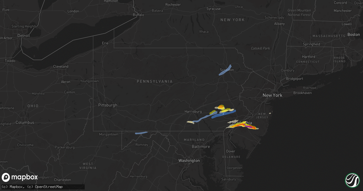
Hail Map in Pennsylvania on May 20, 2022
Get this storm
May 20 map
$229
one time, instant access
Download today. No call, no setup
Keep the $229
Bought the map and want the full workflow? Apply the entire $229 to a subscription within 7 days. None of it is wasted.
Every map, not just this one
This buys you this map. Subscription and you get every map we run, in the markets you choose from a few cities to whole states to nationwide. Plus real-time alerts the moment a storm fires.
Contact data
Name, contact info, occupancy, even credit band for addresses in the footprint. You go from where it hit to who to call.
Become the source they trust
Unlimited branding weather history reports on demand. You already have the documented answer ready for the property owner, and you are the one who showed up with it.
Property data and RoofTrace estimates
Pull up any address you have got, its value and the exact code rules for that jurisdiction, straight from One Click Code. Then RoofTrace estimates the squares, pitch, and roof value, priced the way you price.
Storm reports in Pennsylvania
Pennsylvania
| Date | Description |
|---|---|
| 05/20/20223:18 PM CDT | Trees down. |
| 05/20/20222:58 PM CDT | Social media photo showing a tree down into wires on bells mills road. Road is blocked. Time estimated from radar. |
| 05/20/20222:53 PM CDT | A local report indicates 1.00 inch wind near WOODLYN |
| 05/20/20222:20 PM CDT | A local report indicates 1.00 inch wind near 1 SSE POINT BREEZE |
| 05/20/20222:16 PM CDT | Hail around 1 inch diameter near dickinson square park in south philly. |
| 05/20/20222:15 PM CDT | Hail up to half dollar size in south philly. Time estimated from radar. |
| 05/20/20222:03 PM CDT | Numerous trees down in pictures via social media. Time estimated via radar. |
| 05/20/20222:00 PM CDT | A local report indicates 1.50 inch wind near FOLSOM |
| 05/20/20222:00 PM CDT | A large tree limb estimated to be over 8 inches in diameter took down power lines along the southbound side of allentown road near green hill road and rising sun road. |
| 05/20/20222:00 PM CDT | A local report indicates 1.00 inch wind near UPPER DARBY |
| 05/20/20221:57 PM CDT | Hail slightly less than golf ball sized. Wind damage also reported. Time estimated from radar. |
| 05/20/20221:57 PM CDT | Trees down on link road in fleetwood from a possible microburst. Ping pong ball sized hail also reported. Time estimated from radar. |
| 05/20/20221:57 PM CDT | A local report indicates 1.00 inch wind near ASTON TWP. |
| 05/20/20221:55 PM CDT | Mesonet station ew7427 moosic. |
| 05/20/20221:54 PM CDT | A local report indicates 1.25 inch wind near SWARTHMORE |
| 05/20/20221:50 PM CDT | Report from mping: quarter |
| 05/20/20221:45 PM CDT | Trees down on wires in lititz borough. |
| 05/20/20221:33 PM CDT | Estimated 55 mph wind gust reported as well. |
| 05/20/20221:33 PM CDT | A local report indicates 1.00 inch wind near BOYERTOWN |
| 05/20/20221:19 PM CDT | Trees down on wires near parkway blvd... City of york. |
| 05/20/20221:19 PM CDT | Trees down on wires on walnut street... City of york. |
| 05/20/20221:16 PM CDT | Tress down on wires near route 422 west of annville. |
| 05/20/20221:11 PM CDT | Trees and wires down along gravel hill road. |
| 05/20/20221:06 PM CDT | Hail knocked down branches and leaves from trees. Time estimated from radar. |
| 05/20/20221:00 PM CDT | Several large tree branches down. Time estimated from radar. |
| 05/20/202212:46 PM CDT | Quarter size hail near reinholds. |
| 05/20/202212:35 PM CDT | Trees down on wires near blue ball. |
| 05/20/202211:00 AM CDT | Trees down on wires along rose haven road. |
| 05/20/202210:10 AM CDT | Four large pine trees down across turkeyfoot road. |
| 05/20/20229:48 AM CDT | Trees down on wires. |
| 05/20/20226:41 AM CDT | At 1141 AM EDT, severe thunderstorms were located along a line extending from near Frostburg to near Terra Alta, moving east at 50 mph. HAZARD...60 mph wind gusts and quarter size hail. SOURCE...Radar indicated. IMPACT...Damaging winds will cause some trees and large branches to fall. This could injure those outdoors, as well as damage homes and vehicles. Roadways may become blocked by downed trees. Localized power outages are possible. Unsecured light objects may become projectiles. Locations impacted include... Frostburg, Franklin, Luke, Deep Creek Lake State Park, Merrill, Big Run State Park, New Germany, McComas Beach and Swallow Falls State Park. |
| 05/20/20225:56 AM CDT | At 1055 AM EDT, severe thunderstorms were located along a line extending from Jerome to near Central City to Berlin to Meyersdale, moving northeast at 60 mph. HAZARD...60 mph wind gusts. SOURCE...Radar indicated. IMPACT...Expect damage to roofs, siding, and trees. Locations impacted include... Altoona, Somerset, Hollidaysburg, Windber, Bedford, Breezewood, Roaring Spring, Berlin, New Enterprise, Martinsburg, Lakemont and Everett.This includes the following Interstates... Interstate 70 near mile marker 147. The Pennsylvania Turnpike between mile markers 111 and 161...andfrom mile markers 164 to 173. Interstate 99 from mile markers 0 to 32. |
| 05/19/202210:10 PM CDT | At 310 PM EDT, severe thunderstorms were located along a line extending from Laureldale to near Terre Hill to near Gap, moving east at 35 mph. HAZARD...60 mph wind gusts and quarter size hail. SOURCE...Radar indicated. IMPACT...Minor damage to vehicles is possible. Wind damage to roofs, siding, trees, and power lines is possible. Locations impacted include... Reading, Pottstown, Phoenixville, Coatesville, Wyomissing, Downingtown, Birdsboro, Collegeville, Royersford, Sinking Spring, Laureldale, Trappe, East Greenville, Honey Brook, Schwenksville, Elverson, Bally, Bechtelsville, Green Lane and New Morgan.This includes the following highways... Pennsylvania Turnpike between mile markers 296 and 321. Northeast Extension between mile markers 35 and 51. Interstate 176 in Pennsylvania between mile markers 1 and 11. |
| 05/19/202210:05 PM CDT | At 304 PM EDT, a severe thunderstorm was located over Souderton, or 18 miles south of Allentown, moving east at 35 mph. HAZARD...60 mph wind gusts and quarter size hail. SOURCE...Radar indicated. IMPACT...Minor damage to vehicles is possible. Wind damage to roofs, siding, trees, and power lines is possible. Locations impacted include... Quakertown, Perkasie, Doylestown, Byram, Souderton, Bedminster, Flemington, Chalfont, Tinicum, Hatfield, New Hope, Dublin, Hopewell, Frenchtown, Stockton, Fricks, Lumberville, Ottsville, Sergeantsville and Pipersville.This includes Northeast Extension between mile markers 31 and 41. |
| 05/19/202210:00 PM CDT | At 300 PM EDT, a severe thunderstorm was located over Swarthmore, or 11 miles west of Gloucester City, moving east at 30 mph. HAZARD...60 mph wind gusts and quarter size hail. SOURCE...Radar indicated. IMPACT...Minor damage to vehicles is possible. Wind damage to roofs, siding, trees, and power lines is possible. Locations impacted include... Philadelphia, Camden, Gloucester City, Cherry Hill, Chester, Deptford, Voorhees, West Deptford, Lindenwold, Bellmawr, Yeadon, Woodbury, Palmyra, Folcroft, Swarthmore, Paulsboro, Magnolia, Westville, Woodbury Heights and National Park.This includes the following highways... New Jersey Turnpike near exit 3. Interstate 95 in Pennsylvania between mile markers 3 and 29. Interstate 76 in Pennsylvania between mile markers 342 and 351. Interstate 76 in New Jersey between mile markers 0 and 3. Interstate 295 in New Jersey between mile markers 11 and 36. Interstate 676 in Pennsylvania between mile markers 0 and 1. Interstate 676 in New Jersey between mile markers 0 and 4. Interstate 476 in Pennsylvania between mile markers 0 and 6. |
| 05/19/20229:53 PM CDT | At 253 PM EDT, a severe thunderstorm was located over Laureldale, or near Reading, moving east at 25 mph. HAZARD...60 mph wind gusts and half dollar size hail. SOURCE...Radar indicated. IMPACT...Minor damage to vehicles is possible. Wind damage to roofs, siding, trees, and power lines is possible. Locations impacted include... Reading, Pottstown, Wyomissing, Kutztown, Fleetwood, Laureldale, Topton, Bally, Bechtelsville, Lyons, Ancient Oaks, Gilbertsville, Stowe, Shillington, West Reading, Boyertown, Mount Penn, Kenhorst, Alburtis and St. Lawrence.This includes Interstate 176 in Pennsylvania between mile markers 10and 11. |
| 05/19/20229:52 PM CDT | At 251 PM EDT, a severe thunderstorm was located over Dunmore, or over Scranton, moving northeast at 45 mph. HAZARD...60 mph wind gusts and penny size hail. SOURCE...Radar indicated. IMPACT...Expect damage to roofs, siding, and trees. Locations impacted include... Scranton, Dunmore, Carbondale, Archbald, Blakely, Taylor, Dickson City, Moosic, Olyphant and Clarks Summit. |
| 05/19/20229:33 PM CDT | At 232 PM EDT, a severe thunderstorm was located over Salunga-Landisville, moving east at 45 mph. HAZARD...70 mph wind gusts and penny size hail. SOURCE...Radar indicated. IMPACT...Expect considerable tree damage. Damage is likely to mobile homes, roofs, and outbuildings. This severe thunderstorm will be near... Lititz and Rothsville around 240 PM EDT. Ephrata, Akron and New Holland around 250 PM EDT. Terre Hill, Adamstown and Churchtown around 300 PM EDT.Other locations impacted by this severe thunderstorm includeSmoketown, Washington Boro, Bowmansville, Penryn and Fivepointville.This includes The Pennsylvania Turnpike from mile markers 265 to 295. |
| 05/19/20229:30 PM CDT | At 230 PM EDT, severe thunderstorms were located along a line extending from near Fredericksburg to Myerstown to Timber Hills, moving northeast at 50 mph. HAZARD...60 mph wind gusts and quarter size hail. SOURCE...Radar indicated. IMPACT...Minor damage to vehicles is possible. Wind damage to roofs, siding, trees, and power lines is possible. Locations impacted include... Reading, Wyomissing, Kutztown, Hamburg, Fleetwood, Sinking Spring, Laureldale, Womelsdorf, Wernersville, Robesonia, Leesport, Shoemakersville, Bernville, Lyons, Strausstown, Lenhartsville, Spring Ridge, Fairview Hgts, Shillington and West Reading.This includes the following highways... Interstate 78 in Pennsylvania between mile markers 10 and 42. Interstate 176 in Pennsylvania near mile marker 11. |
| 05/19/20229:22 PM CDT | At 222 PM EDT, a severe thunderstorm was located near Birdsboro, or 10 miles east of Reading, moving northeast at 30 mph. HAZARD...60 mph wind gusts and quarter size hail. SOURCE...Radar indicated. IMPACT...Minor damage to vehicles is possible. Wind damage to roofs, siding, trees, and power lines is possible. Locations impacted include... Pottstown, Emmaus, Souderton, Birdsboro, Hatfield, East Greenville, Schwenksville, Bally, Bechtelsville, Green Lane, Zionsville, Spring Mount, Geryville, Gilbertsville, Cedarville, Stowe, Telford, Sellersville, Boyertown and Pennsburg.This includes Northeast Extension between mile markers 32 and 51. |
| 05/19/20229:11 PM CDT | At 211 PM EDT, a severe thunderstorm was located over Palmyra, moving east at 40 mph. HAZARD...60 mph wind gusts. SOURCE...Radar indicated. IMPACT...Expect damage to roofs, siding, and trees. This severe thunderstorm will be near... Cornwall, Cleona and Pleasant Hill around 220 PM EDT. Lebanon, Avon and Sand Hill around 230 PM EDT. Myerstown, Richland and Newmanstown around 240 PM EDT.Other locations impacted by this severe thunderstorm include Ono,Avon Heights, Hershey Park, Penn State College Of Medicine andJonestown.This includes the following Interstates... Interstate 78 from mile markers 0 to 8. Interstate 81 from mile markers 78 to 91. |
| 05/19/20228:58 PM CDT | At 157 PM EDT, a severe thunderstorm was located over Lake Meade, moving east at 40 mph. HAZARD...60 mph wind gusts and quarter size hail. SOURCE...Radar indicated. IMPACT...Hail damage to vehicles is expected. Expect wind damage to roofs, siding, and trees. This severe thunderstorm will be near... York Airport around 200 PM EDT. Weigelstown, Dover and Shiloh around 210 PM EDT. York, Manchester and Mount Wolf around 220 PM EDT. Elizabethtown, Maytown and Rheems around 230 PM EDT. Mount Joy, Manheim and Columbia around 240 PM EDT.Other locations impacted by this severe thunderstorm include YorkHaven, Washington Boro, Lewisberry, Franklintown and Goldsboro.This includes the following Interstates... The Pennsylvania Turnpike from mile markers 265 to 267. Interstate 83 from mile markers 18 to 34. |
| 05/19/20228:45 PM CDT | At 145 PM EDT, severe thunderstorms were located along a line extending from near Denver to near Adamstown to Churchtown, moving northeast at 35 mph. HAZARD...60 mph wind gusts and nickel size hail. SOURCE...Radar indicated. IMPACT...Damage to roofs, siding, trees, and power lines is possible. Locations impacted include... Reading, Pottstown, Wyomissing, Birdsboro, Sinking Spring, Laureldale, Wernersville, Robesonia, Honey Brook, Elverson, Bechtelsville, New Morgan, Spring Ridge, Pughtown, Glenmoore, Gilbertsville, Cedarville, Stowe, Shillington and West Reading.This includes the following highways... Pennsylvania Turnpike between mile markers 296 and 307. Interstate 176 in Pennsylvania between mile markers 1 and 11. |
| 05/19/20228:41 PM CDT | At 141 PM EDT, a severe thunderstorm was located over Enola, moving northeast at 50 mph. HAZARD...60 mph wind gusts. SOURCE...Radar indicated. IMPACT...Expect damage to roofs, siding, and trees. This severe thunderstorm will be near... Colonial Park, Linglestown and Paxtonia around 150 PM EDT. Hershey, Penn National Race Course and Skyline View around 200 PM EDT. Lickdale and Fredericksburg around 210 PM EDT.Other locations impacted by this severe thunderstorm include Ono,Dauphin, City Island, Harrisburg Area Community College andJonestown.This includes the following Interstates... The Pennsylvania Turnpike from mile markers 235 to 237. Interstate 78 from mile markers 0 to 8. Interstate 81 from mile markers 56 to 96. Interstate 83 from mile markers 40 to 50. |
| 05/19/20228:18 PM CDT | At 118 PM EDT, a severe thunderstorm was located over Cashtown, moving northeast at 55 mph. HAZARD...60 mph wind gusts. SOURCE...Radar indicated. IMPACT...Expect damage to roofs, siding, and trees. This severe thunderstorm will be near... Cashtown and Orrtanna around 120 PM EDT. Aspers, Pine Grove Furnace and Mount Holly Springs around 130 PM EDT. Dillsburg, Lake Meade and Siddonsburg around 140 PM EDT. Valley Green, Manchester and Mount Wolf around 150 PM EDT.Other locations impacted by this severe thunderstorm includeArendtsville, York Haven, Franklintown, York Springs and Gardners.This includes the following Interstates... The Pennsylvania Turnpike from mile markers 236 to 245. Interstate 81 from mile markers 19 to 20. Interstate 83 from mile markers 25 to 40. |
| 05/19/20228:14 PM CDT | At 113 PM EDT, a severe thunderstorm was located over Salunga-Landisville, moving northeast at 30 mph. HAZARD...60 mph wind gusts and quarter size hail. SOURCE...Radar indicated. IMPACT...Hail damage to vehicles is expected. Expect wind damage to roofs, siding, and trees. This severe thunderstorm will be near... Lititz around 120 PM EDT. Akron, Rothsville and Brickerville around 130 PM EDT. Ephrata, New Holland and Reamstown around 140 PM EDT. Adamstown and Terre Hill around 150 PM EDT.Other locations impacted by this severe thunderstorm includeGoodville, Schoeneck, Bowmansville, Penryn and Fivepointville.This includes The Pennsylvania Turnpike from mile markers 271 to 295. |
All States Impacted by Hail Map on May 20, 2022
Cities Impacted by Hail Map on May 20, 2022
- Empire, MI
- Kewaunee, WI
- Menominee, MI
- Stephenson, MI
- Cedarville, MI
- Hinckley, IL
- Hebbronville, TX
- Seymour, IL
- Mahomet, IL
- Waterman, IL
- Deepwater, MO
- Lowry City, MO
- Osceola, MO
- Warsaw, MO
- Coffeen, IL
- Neptune, NJ
- Wentzville, MO
- Warrenton, MO
- Hermann, MO
- Wright City, MO
- Truesdale, MO
- Jonesburg, MO
- New Florence, MO
- Marthasville, MO
- High Hill, MO
- Rhineland, MO
- Foristell, MO
- Dixon, MO
- Bushnell, IL
- Washington, MO
- Johannesburg, MI
- Hawks, MI
- Traverse City, MI
- Posen, MI
- Mancelona, MI
- Elmira, MI
- Bellaire, MI
- Kewadin, MI
- Alden, MI
- East Jordan, MI
- Vanderbilt, MI
- Elk Rapids, MI
- Rogers City, MI
- Atlanta, MI
- Gaylord, MI
- Onaway, MI
- Presque Isle, MI
- Boyne Falls, MI
- Rapid City, MI
- Millersburg, MI
- Axson, GA
- Warrensburg, MO
- Centerview, MO
- Immokalee, FL
- Labelle, FL
- Wellsville, MO
- Montgomery City, MO
- Martinsburg, MO
- La Harpe, IL
- Dallas City, IL
- Modoc, IL
- Adair, IL
- Macomb, IL
- Elverson, PA
- Marshfield, MO
- Lakeview, MI
- Coral, MI
- Pierson, MI
- Howard City, MI
- Hollywood, FL
- Cuba, IL
- Ipava, IL
- Lewistown, IL
- Bardolph, IL
- Perry, OK
- Carthage, IL
- Chadwick, MO
- Garrison, MO
- Pompano Beach, FL
- Robesonia, PA
- Fleetwood, PA
- Temple, PA
- Oley, PA
- Douglassville, PA
- Reading, PA
- Bernville, PA
- Wernersville, PA
- Leesport, PA
- Boyertown, PA
- Birdsboro, PA
- Brooksville, FL
- Broken Arrow, OK
- Deal, NJ
- Vincentown, NJ
- Ochopee, FL
- Verona, MO
- Cassville, MO
- Monett, MO
- Purdy, MO
- Pickford, MI
- Hessel, MI
- Saint Ignace, MI
- Mount Pleasant, MI
- Ellison Bay, WI
- Washington Island, WI
- Baileys Harbor, WI
- Sister Bay, WI
- Rushville, IL
- Beardstown, IL
- Eldon, MO
- Tuscumbia, MO
- Pembroke, GA
- Douglas, GA
- Northport, MI
- Denmark, WI
- Green Bay, WI
- Luxemburg, WI
- Mackinac Island, MI
- Curryville, MO
- Plano, IL
- Sugar Grove, IL
- Big Rock, IL
- Yorkville, IL
- Aurora, IL
- Bristol, IL
- Sandwich, IL
- Kinderhook, IL
- Chatsworth, NJ
- Chamois, MO
- Linn, MO
- Morrison, MO
- Clifton, IL
- Broxton, GA
- Chandlerville, IL
- Bath, IL
- Mount Sterling, IL
- Versailles, IL
- Bristow, OK
- Mannford, OK
- Bingham, IL
- Ramsey, IL
- Mackinaw City, MI
- Pearson, GA
- South Bend, IN
- Green Ridge, MO
- La Monte, MO
- Fort Lauderdale, FL
- Pembroke Pines, FL
- Clinton, MO
- Edwards, MO
- Lincoln, MO
- Edmond, OK
- Oklahoma City, OK
- Colcord, OK
- Wauchula, FL
- Fort Meade, FL
- Leasburg, MO
- Maple Shade, NJ
- Jasper, FL
- Tahlequah, OK
- Hulbert, OK
- Hillman, MI
- Parkersburg, IA
- Perkiomenville, PA
- Mohnton, PA
- Zieglerville, PA
- Frederick, PA
- Green Lane, PA
- Pottstown, PA
- Gilbertsville, PA
- Morgantown, PA
- Harleysville, PA
- Schwenksville, PA
- Telford, PA
- Liberty, IL
- Salina, OK
- Jay, OK
- Algoma, WI
- Saint Louis, MI
- Midland, MI
- Breckenridge, MI
- Shepherd, MI
- Cedar, MI
- Maple City, MI
- Wentworth, MO
- Riverdale, MI
- Vestaburg, MI
- Hennessey, OK
- Dover, OK
- Sturgeon Bay, WI
- Egg Harbor, WI
- Vermont, IL
- Selma, AL
- Tyler, AL
- Chilhowee, MO
- Leeton, MO
- Blairstown, MO
- Fort Pierce, FL
- Jensen Beach, FL
- Casco, WI
- New Franken, WI
- Forestville, WI
- Levering, MI
- Carp Lake, MI
- Harbor Springs, MI
- Oshkosh, WI
- Van Dyne, WI
- Henry, IL
- Sparland, IL
- Media, PA
- Camden, NJ
- Merchantville, NJ
- Pennsauken, NJ
- Darby, PA
- Haddon Heights, NJ
- Blackwood, NJ
- Magnolia, NJ
- Brookhaven, PA
- Collingswood, NJ
- Morton, PA
- Westville, NJ
- Gibbsboro, NJ
- Marcus Hook, PA
- Essington, PA
- Philadelphia, PA
- Woodlyn, PA
- Thorofare, NJ
- Wallingford, PA
- Gloucester City, NJ
- Hockessin, DE
- Sharon Hill, PA
- Crum Lynne, PA
- Haddonfield, NJ
- Marlton, NJ
- Riverside, NJ
- Claymont, DE
- Folcroft, PA
- Chester, PA
- Barrington, NJ
- Voorhees, NJ
- Aston, PA
- Chadds Ford, PA
- Thornton, PA
- Glenolden, PA
- Wilmington, DE
- Chester Heights, PA
- Somerdale, NJ
- Norwood, PA
- Riverton, NJ
- Prospect Park, PA
- Swarthmore, PA
- Cherry Hill, NJ
- Oaklyn, NJ
- Bellmawr, NJ
- Holmes, PA
- National Park, NJ
- Glendora, NJ
- Glen Mills, PA
- Folsom, PA
- Runnemede, NJ
- Mount Ephraim, NJ
- Audubon, NJ
- Moorestown, NJ
- Garnet Valley, PA
- Ridley Park, PA
- Lawnside, NJ
- Medford, NJ
- Champaign, IL
- Niangua, MO
- Wyoming, IL
- Speer, IL
- Muskegon, MI
- Altamont, IL
- Stewardson, IL
- Shumway, IL
- Beecher City, IL
- Toulon, IL
- North Liberty, IN
- Walkerton, IN
- Bland, MO
- Barry, IL
- Pryor, OK
- Arkansas City, KS
- Garber, OK
- Billings, OK
- Inola, OK
- South Greenfield, MO
- Lockwood, MO
- York Springs, PA
- East Berlin, PA
- York, PA
- Dover, PA
- Thomasville, PA
- Spring Grove, PA
- Eugene, MO
- Vandalia, MO
- Galena, MO
- Sigel, IL
- Teutopolis, IL
- Claxton, GA
- Avon, IL
- Prairie City, IL
- Earlville, IL
- Ava, MO
- Seymour, MO
- Marshall, MO
- Nelson, MO
- Houstonia, MO
- Aurora, MO
- Crane, MO
- Lamar, MO
- Granby, MO
- Pierce City, MO
- Stark City, MO
- Dekalb, IL
- Maple Park, IL
- Freeburg, MO
- Plant City, FL
- Mazon, IL
- Gardner, IL
- Dwight, IL
- Zolfo Springs, FL
- Arcadia, FL
- Cabool, MO
- Mountain Grove, MO
- Oakwood, OK
- Ponca City, OK
- Rolla, MO
- Proctor, OK
- Homosassa, FL
- Reeds Spring, MO
- Walnut Shade, MO
- Elburn, IL
- Butler, MO
- Loxahatchee, FL
- Salem, MO
- Merion Station, PA
- Narberth, PA
- Havertown, PA
- Newtown Square, PA
- Villanova, PA
- Broomall, PA
- Haverford, PA
- Malvern, PA
- Bala Cynwyd, PA
- Berwyn, PA
- West Chester, PA
- Ardmore, PA
- Bryn Mawr, PA
- Wynnewood, PA
- Kinsman, IL
- Saint Thomas, MO
- Meta, MO
- Saint Elizabeth, MO
- Koeltztown, MO
- Argyle, MO
- Henley, MO
- Westphalia, MO
- Browning, IL
- Frederick, IL
- Oakford, IL
- Williamsport, IN
- Oldfield, MO
- Stella, MO
- Rocky Comfort, MO
- Wheaton, MO
- Fairview, MO
- Claremore, OK
- Chouteau, OK
- Davenport, FL
- Strafford, MO
- Waynesville, MO
- Longdale, OK
- Southard, OK
- Seiling, OK
- Okeene, OK
- Canton, OK
- Watonga, OK
- Albany, TX
- Billingsley, AL
- Schell City, MO
- Harwood, MO
- Newburg, MO
- Tunas, MO
- Autaugaville, AL
- Throckmorton, TX
- Festus, MO
- Everton, MO
- Greenfield, MO
- Coweta, OK
- Lebanon, MO
- Grovespring, MO
- Conway, MO
- Kansas, OK
- Westville, OK
- Watts, OK
- Macks Creek, MO
- Peggs, OK
- Locust Grove, OK
- Wagoner, OK
- Statenville, GA
- Lake Park, GA
- Palm City, FL
- Siloam Springs, AR
- Springfield, MO
- Brighton, MO
- Pleasant Hope, MO
- Republic, MO
- Billings, MO
- Rose, OK
- Prattville, AL
- Stuart, FL
- Hitchcock, OK
- Branson, MO
- Valrico, FL
- Dover, FL
- Seffner, FL
- Ozark, MO
- Chestnutridge, MO
- Forsyth, MO
- Afton, MI
- Central Lake, MI
- Wolverine, MI
- Honor, MI
- Glen Arbor, MI
- Lake Leelanau, MI
- Denver, PA
- Reinholds, PA
- Ephrata, PA
- Landisville, PA
- Akron, PA
- Adamstown, PA
- Maytown, PA
- Manheim, PA
- Lititz, PA
- Columbia, PA
- Mount Joy, PA
- Stevens, PA
- Marietta, PA
- Line Lexington, PA
- Spring City, PA
- Terre Hill, PA
- Sellersville, PA
- New Holland, PA
- Royersford, PA
- Collegeville, PA
- Chalfont, PA
- Bird In Hand, PA
- Leola, PA
- Hilltown, PA
- Doylestown, PA
- Perkasie, PA
- Narvon, PA
- Warrington, PA
- Souderton, PA
- Furlong, PA
- Hatfield, PA
- East Earl, PA
- New Hope, PA
- Shavertown, PA
- Olyphant, PA
- Waymart, PA
- Jessup, PA
- Moosic, PA
- Prompton, PA
- Peckville, PA
- Kingston, PA
- Taylor, PA
- Jermyn, PA
- Wyoming, PA
- Honesdale, PA
- Carbondale, PA
- Duryea, PA
- Scranton, PA
- Archbald, PA
- Plymouth, PA
- Pittston, PA
- Luzerne, PA
- Moscow, PA
- Wilkes Barre, PA
- Old Forge, PA
- Midlothian, MD
- Flintstone, MD
- Mount Savage, MD
- Frostburg, MD
- Cumberland, MD
- Ridgeley, WV
- Port Saint Lucie, FL
- Jupiter, FL
- Indiantown, FL
- Timewell, IL
- Hartshorn, MO
- Mansfield, MO
- Elk Creek, MO
- Hartville, MO
- Huggins, MO
- Eunice, MO
- Graff, MO
- Plato, MO
- Summersville, MO
- Solo, MO
- Macomb, MO
- Licking, MO
- Yukon, MO
- Norwood, MO
- Houston, MO
- Raymondville, MO
- Success, MO
- Bucyrus, MO
- Duke, MO
- Belle, MO
- Crocker, MO
- Saint James, MO
- Devils Elbow, MO
- Fort Leonard Wood, MO
- Saint Robert, MO
- Vichy, MO
- Brinktown, MO
- Edgar Springs, MO
- Vienna, MO
- Jerome, MO
- Bechtelsville, PA
- Barto, PA
- Blandon, PA
- Springfield, PA
- Clifton Heights, PA
- Drexel Hill, PA
- Lansdowne, PA


