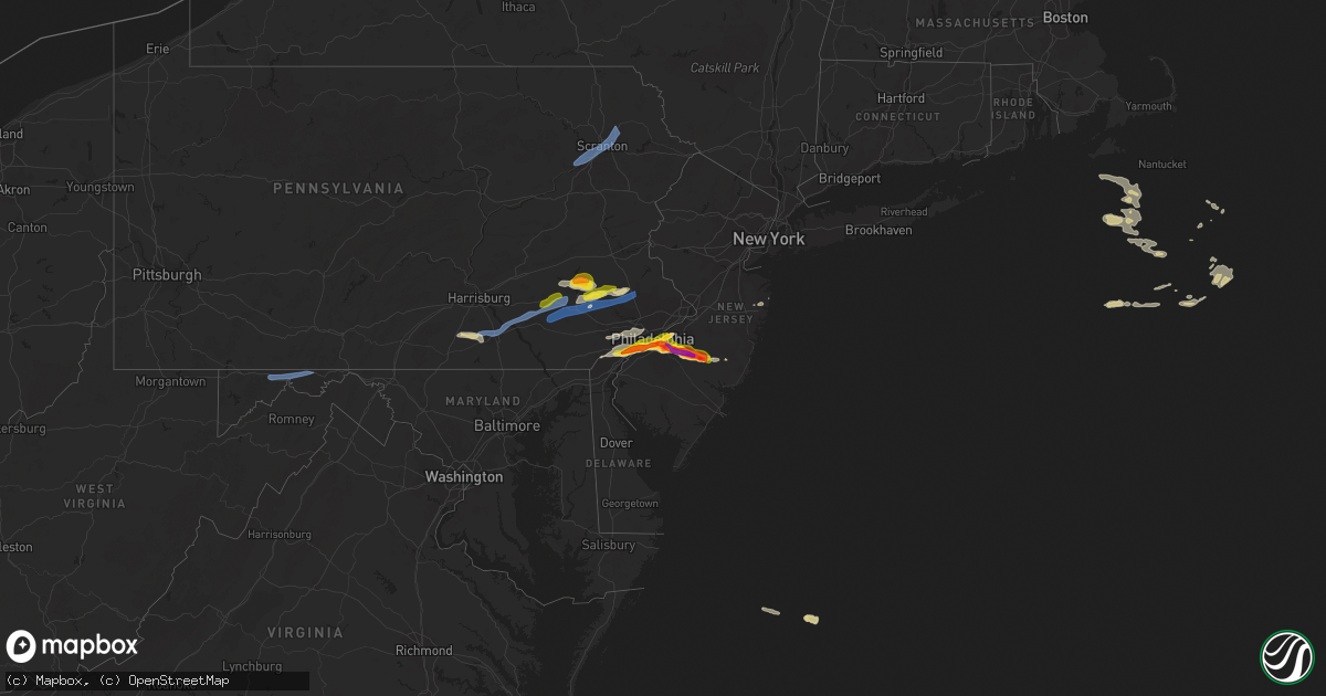
Hail Map on May 20, 2022
Get this storm
May 20 map
$229
one time, instant access
Download today. No call, no setup
Keep the $229
Bought the map and want the full workflow? Apply the entire $229 to a subscription within 7 days. None of it is wasted.
Every map, not just this one
This buys you this map. Subscription and you get every map we run, in the markets you choose from a few cities to whole states to nationwide. Plus real-time alerts the moment a storm fires.
Contact data
Name, contact info, occupancy, even credit band for addresses in the footprint. You go from where it hit to who to call.
Become the source they trust
Unlimited branding weather history reports on demand. You already have the documented answer ready for the property owner, and you are the one who showed up with it.
Property data and RoofTrace estimates
Pull up any address you have got, its value and the exact code rules for that jurisdiction, straight from One Click Code. Then RoofTrace estimates the squares, pitch, and roof value, priced the way you price.
States Impacted by Hail Map on May 20, 2022
Storm reports
Kentucky
| Date | Description |
|---|---|
| 05/20/20227:18 AM CDT | At 1218 AM EDT, a severe thunderstorm was located over Aberdeen, moving east at 30 mph. HAZARD...60 mph wind gusts and quarter size hail. SOURCE...Radar indicated. IMPACT...Minor hail damage to vehicles is possible. Expect wind damage to trees and power lines. Locations impacted include... West Union, Manchester, Rome, Concord, Bentonville, Trinity, Dunkinsville, Carrs, Bradysville and Cedar Mills. |
| 05/20/20227:14 AM CDT | At 1214 AM EDT, a severe thunderstorm was located near Fairview, or 14 miles west of Flemingsburg, moving east at 40 mph. HAZARD...60 mph wind gusts and quarter size hail. SOURCE...Radar indicated. IMPACT...Hail damage to vehicles is expected. Expect wind damage to roofs, siding, and trees. This severe thunderstorm will be near... Fairview around 1220 AM EDT. Cowan around 1225 AM EDT. Nepton around 1230 AM EDT.Other locations in the path of this severe thunderstorm includeFlemingsburg and Mount Carmel. |
| 05/19/202211:28 PM CDT | At 428 AM EDT, a severe thunderstorm was located over Alexandria, moving east at 45 mph. HAZARD...60 mph wind gusts. SOURCE...Radar indicated. IMPACT...Expect damage to trees and power lines. Locations impacted include... Cincinnati, Fort Thomas, Alexandria, Highland Heights, Georgetown, Forestville, Amelia, Mount Orab, Bethel, New Richmond, Williamsburg, Batavia, Silver Grove, Felicity, Melbourne, Riverbend And Coney Island, Coldstream, Salem Heights, Withamsville and Cold Spring. |
| 05/19/202210:52 PM CDT | At 352 AM EDT, a severe thunderstorm was located 7 miles northwest of Madison, moving east at 50 mph. HAZARD...60 mph wind gusts and penny size hail. SOURCE...Radar indicated. IMPACT...Expect damage to roofs, siding, and trees. Locations impacted include... Madison, Smyrna, Brooksburg, Wakefield, Middlefork, Canaan, Volga, North Madison, Manville, and Belleview. |
Missouri
| Date | Description |
|---|---|
| 05/20/20226:49 AM CDT | Wind damage reported to a pecan tree about 8 to 9 inches in diameter at the break point. Located near highway 65 and sunshine street. Time estimated from radar. |
| 05/20/20226:48 AM CDT | At 1148 PM CDT, a severe thunderstorm was located over Fairview, or 9 miles southwest of Monett, moving east at 15 mph. HAZARD...60 mph wind gusts and quarter size hail. SOURCE...Radar indicated. IMPACT...Hail damage to vehicles is expected. Expect wind damage to roofs, siding, and trees. Locations impacted include... Monett... Pierce City... Purdy... Wheaton... Fairview... Newtonia... Pioneer... Freistatt... Stark City... Mcdowell... |
| 05/20/20226:16 AM CDT | Picture via social media of a tree down on greentree road. |
| 05/20/20224:54 AM CDT | At 953 PM CDT, a severe thunderstorm was located near Warrenton, moving east at 30 mph. HAZARD...60 mph wind gusts and quarter size hail. SOURCE...Radar indicated. IMPACT...Hail damage to vehicles is expected. Expect wind damage to roofs, siding, and trees. This severe thunderstorm will be near... Warrenton and Truesdale around 1005 PM CDT.Other locations in the path of this severe thunderstorm includeWright City, Innsbrook, New Melle, Wentzville, Chain of Rocks,O'Fallon, Lake St. Louis, Dardenne Prairie, St. Paul and Josephville.This includes Interstate 70 in Missouri between exits 188 and 214. |
| 05/20/20223:35 AM CDT | At 834 PM CDT, a severe thunderstorm was located over Wellsville, moving northeast at 30 mph. HAZARD...60 mph wind gusts and quarter size hail. SOURCE...Radar indicated. IMPACT...Hail damage to vehicles is expected. Expect wind damage to roofs, siding, and trees. Locations impacted include... New Hartford. |
| 05/20/20221:13 AM CDT | At 612 AM CDT, a severe thunderstorm was located over Vincennes, or 8 miles northeast of Kahoka, moving northeast at 70 mph. HAZARD...Quarter size hail. SOURCE...Radar indicated. IMPACT...Damage to vehicles is expected. This severe thunderstorm will be near... Nauvoo, Montrose, Franklin, Wilson Lake, Bluff Park, Nauvoo State Park and Galland around 620 AM CDT. West Point, Niota and Pollmiller Park around 625 AM CDT. Fort Madison, Denmark, Pontoosuc, Sawyer and Fort Madison Municipal Arpt around 630 AM CDT.Other locations in the path of this severe thunderstorm includeDallas City, Wever and Augusta. |
| 05/20/202212:00 AM CDT | A local report indicates 1.25 inch wind near 4 ESE PIONEER |
| 05/19/202210:58 PM CDT | At 358 AM CDT, a severe thunderstorm was located over Gilman City, or 12 miles southeast of Bethany, moving east at 45 mph. HAZARD...Quarter size hail. SOURCE...Radar indicated. IMPACT...Damage to vehicles is expected. Locations impacted include... Trenton, Jamesport, Gilman City, Spickard, Galt, Laredo, Tindall and Brimson. |
| 05/19/202210:37 PM CDT | Report from mping: quarter |
| 05/19/202210:32 PM CDT | Report from mping: quarter |
| 05/19/202210:26 PM CDT | At 326 AM CDT, a severe thunderstorm was located 8 miles south of Albany, moving northeast at 50 mph. HAZARD...Quarter size hail. SOURCE...Radar indicated. IMPACT...Damage to vehicles is expected. Locations impacted include... Bethany, Albany, Gilman City, Pattonsburg, New Hampton, Coffey, Darlington, Mcfall, Gentry and Martinsville.This includes Interstate 35 in Missouri between mile markers 75 and101. |
| 05/19/20229:59 PM CDT | At 259 AM CDT, a severe thunderstorm was located near Maitland, or 11 miles southwest of Maryville, moving east at 35 mph. HAZARD...Quarter size hail. SOURCE...Radar indicated. IMPACT...Damage to vehicles is expected. Locations impacted include... Maryville, Stanberry, King City, Ravenwood, Skidmore, Barnard, Conception Junction, Bolckow, Rosendale, Guilford, Clyde, Arkoe, Rea, Conception and Ford City. |
Arkansas
| Date | Description |
|---|---|
| 05/20/20226:39 AM CDT | At 1139 PM CDT, a severe thunderstorm was located 6 miles southwest of Scraper, moving northeast at 25 mph. HAZARD...60 mph wind gusts and half dollar size hail. SOURCE...Radar indicated. IMPACT...Hail damage to vehicles is expected. Expect wind damage to roofs, siding, and trees. Locations in or near the path include... Tahlequah... Westville... West Siloam Springs... Watts... Oaks... Proctor... Christie... Scraper... Eldon... Twin Oaks... Ballard... Natural Falls State Park... |
| 05/20/20225:48 AM CDT | At 1047 PM CDT, a severe thunderstorm was located near Peggs, moving northeast at 25 mph. HAZARD...60 mph wind gusts and quarter size hail. SOURCE...Radar indicated. IMPACT...Hail damage to vehicles is expected. Expect wind damage to roofs, siding, and trees. Locations in or near the path include... Siloam Springs... Jay... West Siloam Springs... Colcord... Kansas... Hulbert... Watts... Oaks... Maysville... Peggs... Rose... Leach... Scraper... Twin Oaks... Lake Eucha State Park... Ballard... Lost City... Natural Falls State Park... |
Delaware
| Date | Description |
|---|---|
| 05/19/202210:37 PM CDT | At 337 PM EDT, severe thunderstorms were located along a line extending from near East Norriton to Newtown Square to Talleyville, moving east at 45 mph. HAZARD...60 mph wind gusts and quarter size hail. SOURCE...Radar indicated. IMPACT...Minor damage to vehicles is possible. Wind damage to roofs, siding, trees, and power lines is possible. Locations impacted include... Philadelphia, Trenton, Camden, Wilmington, West Chester, Gloucester City, Cherry Hill, Bensalem, Mount Laurel, Ewing, Norristown, Chester, Willingboro, Deptford, Voorhees, Pottstown, West Deptford, Glassboro, Lindenwold and Phoenixville.This includes the following highways... New Jersey Turnpike between exits 2 and 6A. Pennsylvania Turnpike between mile markers 318 and 359. Northeast Extension between mile markers 21 and 31. Interstate 95 in Pennsylvania between mile markers 0 and 40. Interstate 95 in Delaware between mile markers 15 and 23. Interstate 76 in Pennsylvania between mile markers 327 and 351. Interstate 76 in New Jersey between mile markers 0 and 3. Interstate 295 in New Jersey between mile markers 8 and 51, andbetween mile markers 65 and 76. Interstate 676 in Pennsylvania between mile markers 0 and 1. Interstate 676 in New Jersey between mile markers 0 and 4. Interstate 476 in Pennsylvania between mile markers 0 and 19. Atlantic City Expressway between mile markers 41 and 44. |
New Jersey
| Date | Description |
|---|---|
| 05/20/20224:25 PM CDT | Picture via social media. Time estimated via radar. |
| 05/20/20224:12 PM CDT | Picture via social media. Time estimated via radar. |
| 05/20/20224:12 PM CDT | Time estimated from radar. |
| 05/20/20224:11 PM CDT | Multiple trees down in a yard... One of which crashed through a fence. Pictures via social media. |
| 05/20/20224:10 PM CDT | Three downed telephone poles along route 35 in hazlet near keyport. Time estimated from radar. |
| 05/20/20224:05 PM CDT | Shamong. Social media picture and measurements. Multiple 2 inch hailstones with several 1-2 inch hailstones. Along medford/shamong border on atsion road. |
| 05/20/20224:05 PM CDT | Corrects time from previous hail report from 3 sse medford lakes. Corrects previous hail report from 3 sse medford lakes. Report from mping: ping pong ball |
| 05/20/20223:55 PM CDT | Report from mping: quarter |
| 05/20/20223:52 PM CDT | Time estimated from radar. |
| 05/20/20223:47 PM CDT | Time estimated from radar. |
| 05/20/20223:45 PM CDT | Edit for correct time. |
| 05/20/20223:45 PM CDT | A local report indicates 1.50 inch wind near EVESHAM TWP |
| 05/20/20223:43 PM CDT | Report from mping: quarter |
| 05/20/20223:42 PM CDT | Time estimated from radar. |
| 05/20/20223:42 PM CDT | Picture via social media. Time estimated via radar. |
| 05/20/20223:40 PM CDT | Social media image. Time estimated via radar. |
| 05/20/20223:40 PM CDT | Half dollar sized hail in voorhees. Time estimated from radar. |
| 05/20/20223:40 PM CDT | Time estimated from radar. |
| 05/20/20223:37 PM CDT | Picture via social media. Time estimated via radar. |
| 05/20/20223:37 PM CDT | Corrects previous hail report from cherry hill twp. Via social media picture with measurements. Time estimated from radar. Edit for correct time. |
| 05/20/20223:30 PM CDT | Time estimated from radar. |
| 05/20/20223:27 PM CDT | Time estimated from radar. |
| 05/20/20223:07 PM CDT | Via social media picture with measurements. Time estimated from radar. |
| 05/20/20223:05 PM CDT | Corrects previous hail report from 3 sse medford lakes. Report from mping: ping pong ball |
| 05/20/20223:05 PM CDT | A local report indicates 1.25 inch wind near MARLTON |
| 05/20/202212:54 AM CDT | At 553 PM EDT, a severe thunderstorm was located over Brookville, or 15 miles southwest of Toms River, moving east at 35 mph. This storm has a history of producing hail up to ping pong ball size within the last hour. HAZARD...Ping pong ball size hail and 60 mph wind gusts. SOURCE...Public. IMPACT...People and animals outdoors will be injured. Expect hail damage to roofs, siding, windows, and vehicles. Wind damage to roofs, siding, trees, and power lines is possible. Locations impacted include... Barnegat, Beachwood, Seaside Heights, Brookville, Warren Grove, Bamber Lake, Ocean Acres and Waretown.This includes Garden State Parkway between mile markers 65 and 79. |
| 05/20/202212:20 AM CDT | At 519 PM EDT, severe thunderstorms were located along a line extending from near Keansburg to near Lincroft to near Freewood Acres, moving east at 35 mph. HAZARD...60 mph wind gusts and quarter size hail. SOURCE...Trained weather spotters. IMPACT...Minor damage to vehicles is possible. Wind damage to roofs, siding, trees, and power lines is possible. Locations impacted include... Long Branch, Asbury Park, Sandy Hook, Lakewood, Middletown, Howell, Tinton Falls, Holmdel, Red Bank, Manasquan, Highlands, Point Pleasant Beach, Farmingdale, Mantoloking, Allenwood, East Freehold, Cassville, Adelphia, Vista Center and Elberon.This includes the following highways... Interstate 195 in New Jersey between mile markers 20 and 34. Garden State Parkway between mile markers 91 and 117. |
| 05/20/202212:11 AM CDT | At 509 PM EDT, a severe thunderstorm was located over Tabernacle, or 21 miles east of Gloucester City, moving east at 25 mph. HAZARD...Two inch hail and 60 mph wind gusts. SOURCE...Trained weather spotters. At 437 PM EDT, two and a half inch diameter hail was reported in Cherry Hill. IMPACT...People and animals outdoors will be injured. Expect hail damage to roofs, siding, windows, and vehicles. Wind damage to roofs, siding, trees, and power lines is possible. Locations impacted include... Medford, Tabernacle, Shamong, Tuckerton, Presidential Lakes Estates, Atco, Wharton State Forest, Bamber Lake, Atsion, Brookville, Warren Grove, Bass River State Forest, Leisuretowne, Chatsworth, Old Halfway, Penn State Forest, Medford Lakes and Ocean Acres.This includes Garden State Parkway between mile markers 55 and 60. |
| 05/19/202211:33 PM CDT | At 433 PM EDT, a severe thunderstorm was located over Marlton, or 9 miles east of Camden, moving east at 30 mph. HAZARD...60 mph wind gusts and quarter size hail. SOURCE...Radar indicated. IMPACT...Minor damage to vehicles is possible. Wind damage to roofs, siding, trees, and power lines is possible. Locations impacted include... Cherry Hill, Evesham, Mount Laurel, Voorhees, Medford, Lindenwold, Lumberton, Bellmawr, Mount Holly, Berlin, Tabernacle, Shamong, Magnolia, Presidential Lakes Estates, Pemberton, Wrightstown, Barclay-Kingston, Marlton, Leisuretowne and Wharton State Forest.This includes the following highways... New Jersey Turnpike between exits 3 and 4. Interstate 295 in New Jersey between mile markers 29 and 43. |
| 05/19/202210:41 PM CDT | At 340 PM EDT, severe thunderstorms were located along a line extending from near Emmaus to near Green Lane to Trappe, moving east at 50 mph. HAZARD...70 mph wind gusts and quarter size hail. SOURCE...Radar indicated. IMPACT...Minor damage to vehicles is possible. Expect considerable tree damage. Wind damage is also likely to mobile homes, roofs, and outbuildings. Locations impacted include... Allentown, Trenton, Bethlehem, Ewing, Lansdale, Princeton, Emmaus, Quakertown, Perkasie, Doylestown, Byram, Souderton, Bedminster, Hellertown, Flemington, Chalfont, Tinicum, High Bridge, Hatfield and East Greenville.This includes the following highways... Northeast Extension between mile markers 28 and 55. Interstate 78 in Pennsylvania between mile markers 56 and 71. Interstate 78 in New Jersey near mile marker 2, and between milemarkers 7 and 25. Interstate 295 in New Jersey between mile markers 64 and 76. |
| 05/19/202210:25 PM CDT | At 324 PM EDT, severe thunderstorms were located along a line extending from Arrowhead Lake to near Beltzville State Park to near Wanamakers, moving northeast at 40 mph. HAZARD...60 mph wind gusts and quarter size hail. SOURCE...Radar indicated. IMPACT...Minor damage to vehicles is possible. Wind damage to roofs, siding, trees, and power lines is possible. Locations impacted include... Allentown, Easton, Lehighton, Mount Pocono, Bethlehem, Forks, Northampton, East Stroudsburg, Tobyhanna, Wilson, Hellertown, Nazareth, Palmerton, Bangor, Jim Thorpe, Slatington, Pen Argyl, Wind Gap, Bath and Walnutport.This includes the following highways... Northeast Extension between mile markers 56 and 95. Interstate 78 in Pennsylvania between mile markers 39 and 55, andbetween mile markers 65 and 76. Interstate 80 in Pennsylvania between mile markers 280 and 314. Interstate 80 in New Jersey near mile marker 3. Interstate 380 in Pennsylvania between mile markers 0 and 13. |
| 05/19/20229:27 PM CDT | At 227 PM EDT, a severe thunderstorm was located over Ashland, or 8 miles northwest of Wilmington, moving northeast at 25 mph. HAZARD...60 mph wind gusts and nickel size hail. SOURCE...Radar indicated. IMPACT...Damage to roofs, siding, trees, and power lines is possible. Locations impacted include... Philadelphia, Wilmington, Chester, Yeadon, Westtown, Conshohocken, Folcroft, Swarthmore, Elsmere, Paulsboro, Kennett Square, Westville, Narberth, National Park, East Lansdowne, Brooklawn, Arden, Darby Township, Cheyney and Morris Park.This includes the following highways... Interstate 95 in Pennsylvania between mile markers 0 and 19. Interstate 95 in Delaware between mile markers 15 and 23. Interstate 76 in Pennsylvania between mile markers 331 and 339, andbetween mile markers 341 and 351. Interstate 676 in Pennsylvania near mile marker 0. Interstate 476 in Pennsylvania between mile markers 0 and 18. |
West Virginia
| Date | Description |
|---|---|
| 05/20/202211:59 AM CDT | Tree down near the 2000 block of river rd |
| 05/20/20227:53 AM CDT | At 1253 PM EDT, severe thunderstorms were located along a line extending from near Hancock to near Berkeley Springs, moving east at 45 mph. HAZARD...60 mph wind gusts and quarter size hail. SOURCE...Radar indicated. IMPACT...Damaging winds will cause some trees and large branches to fall. This could injure those outdoors, as well as damage homes and vehicles. Roadways may become blocked by downed trees. Localized power outages are possible. Unsecured light objects may become projectiles. Locations impacted include... Hancock, Berkeley Springs, Great Cacapon, Clear Spring, Pecktonville, Big Pool, Cherry Run, Warrenton, Valley View, Spohrs Crossroads, Spruce Pine Hollow, Berryville, New Hope, Sleepy Creek and Shady Grove. |
| 05/20/20226:29 AM CDT | At 1128 AM EDT, severe thunderstorms were located along a line extending from near Grantsville to 6 miles north of Oakland, moving east at 45 mph. HAZARD...60 mph wind gusts and quarter size hail. SOURCE...Radar indicated. IMPACT...Damaging winds will cause some trees and large branches to fall. This could injure those outdoors, as well as damage homes and vehicles. Roadways may become blocked by downed trees. Localized power outages are possible. Unsecured light objects may become projectiles. Locations impacted include... Cumberland, Frostburg, Westernport, Bel Air, La Vale, Fort Ashby, Lonaconing, Piedmont, Ridgeley, Cresaptown, Potomac Park, Wiley Ford, Eckhart Mines, Mount Savage, Rawlings, Ellerslie, Barton, Corriganville, Midland and Midlothian. |
| 05/20/20226:06 AM CDT | At 1105 AM EDT, severe thunderstorms were located along a line extending from near Ursina to near Kingwood, moving east at 40 mph. HAZARD...60 mph wind gusts and quarter size hail. SOURCE...Radar indicated. IMPACT...Damaging winds will cause some trees and large branches to fall. This could injure those outdoors, as well as damage homes and vehicles. Roadways may become blocked by downed trees. Localized power outages are possible. Unsecured light objects may become projectiles. Locations impacted include... Bittinger, Grantsville, Friendsville, Accident, Merrill, Keysers Ridge, Jennings, Mineral Spring, Deep Creek Lake State Park, Swallow Falls State Park, McHenry, Selbysport, Big Run State Park, New Germany, Piney Grove and McComas Beach. |
| 05/19/20228:28 PM CDT | At 127 AM EDT, a severe thunderstorm was located near Buffalo, or 11 miles north of Winfield, moving east at 40 mph. HAZARD...60 mph wind gusts and penny size hail. SOURCE...Radar indicated. IMPACT...Expect damage to roofs, siding, and trees. Locations impacted include... Ripley, Spencer, Buffalo, Kenna, Leon, Mount Alto, Statts Mills, Harmony, Given, Southside, Kentuck, Liberty, Walton, Cottageville, Grimms Landing, Evans, Looneyville, Fairplain, Gay and Gandeeville.This includes Interstate 77 in West Virginia between mile markers 116and 142. |
Pennsylvania
| Date | Description |
|---|---|
| 05/20/20223:18 PM CDT | Trees down. |
| 05/20/20222:58 PM CDT | Social media photo showing a tree down into wires on bells mills road. Road is blocked. Time estimated from radar. |
| 05/20/20222:53 PM CDT | A local report indicates 1.00 inch wind near WOODLYN |
| 05/20/20222:20 PM CDT | A local report indicates 1.00 inch wind near 1 SSE POINT BREEZE |
| 05/20/20222:16 PM CDT | Hail around 1 inch diameter near dickinson square park in south philly. |
| 05/20/20222:15 PM CDT | Hail up to half dollar size in south philly. Time estimated from radar. |
| 05/20/20222:03 PM CDT | Numerous trees down in pictures via social media. Time estimated via radar. |
| 05/20/20222:00 PM CDT | A local report indicates 1.00 inch wind near UPPER DARBY |
| 05/20/20222:00 PM CDT | A large tree limb estimated to be over 8 inches in diameter took down power lines along the southbound side of allentown road near green hill road and rising sun road. |
| 05/20/20222:00 PM CDT | A local report indicates 1.50 inch wind near FOLSOM |
| 05/20/20221:57 PM CDT | Trees down on link road in fleetwood from a possible microburst. Ping pong ball sized hail also reported. Time estimated from radar. |
| 05/20/20221:57 PM CDT | Hail slightly less than golf ball sized. Wind damage also reported. Time estimated from radar. |
| 05/20/20221:57 PM CDT | A local report indicates 1.00 inch wind near ASTON TWP. |
| 05/20/20221:55 PM CDT | Mesonet station ew7427 moosic. |
| 05/20/20221:54 PM CDT | A local report indicates 1.25 inch wind near SWARTHMORE |
| 05/20/20221:50 PM CDT | Report from mping: quarter |
| 05/20/20221:45 PM CDT | Trees down on wires in lititz borough. |
| 05/20/20221:33 PM CDT | A local report indicates 1.00 inch wind near BOYERTOWN |
| 05/20/20221:33 PM CDT | Estimated 55 mph wind gust reported as well. |
| 05/20/20221:19 PM CDT | Trees down on wires near parkway blvd... City of york. |
| 05/20/20221:19 PM CDT | Trees down on wires on walnut street... City of york. |
| 05/20/20221:16 PM CDT | Tress down on wires near route 422 west of annville. |
| 05/20/20221:11 PM CDT | Trees and wires down along gravel hill road. |
| 05/20/20221:06 PM CDT | Hail knocked down branches and leaves from trees. Time estimated from radar. |
| 05/20/20221:00 PM CDT | Several large tree branches down. Time estimated from radar. |
| 05/20/202212:46 PM CDT | Quarter size hail near reinholds. |
| 05/20/202212:35 PM CDT | Trees down on wires near blue ball. |
| 05/20/202211:00 AM CDT | Trees down on wires along rose haven road. |
| 05/20/202210:10 AM CDT | Four large pine trees down across turkeyfoot road. |
| 05/20/20229:48 AM CDT | Trees down on wires. |
| 05/20/20226:41 AM CDT | At 1141 AM EDT, severe thunderstorms were located along a line extending from near Frostburg to near Terra Alta, moving east at 50 mph. HAZARD...60 mph wind gusts and quarter size hail. SOURCE...Radar indicated. IMPACT...Damaging winds will cause some trees and large branches to fall. This could injure those outdoors, as well as damage homes and vehicles. Roadways may become blocked by downed trees. Localized power outages are possible. Unsecured light objects may become projectiles. Locations impacted include... Frostburg, Franklin, Luke, Deep Creek Lake State Park, Merrill, Big Run State Park, New Germany, McComas Beach and Swallow Falls State Park. |
| 05/20/20225:56 AM CDT | At 1055 AM EDT, severe thunderstorms were located along a line extending from Jerome to near Central City to Berlin to Meyersdale, moving northeast at 60 mph. HAZARD...60 mph wind gusts. SOURCE...Radar indicated. IMPACT...Expect damage to roofs, siding, and trees. Locations impacted include... Altoona, Somerset, Hollidaysburg, Windber, Bedford, Breezewood, Roaring Spring, Berlin, New Enterprise, Martinsburg, Lakemont and Everett.This includes the following Interstates... Interstate 70 near mile marker 147. The Pennsylvania Turnpike between mile markers 111 and 161...andfrom mile markers 164 to 173. Interstate 99 from mile markers 0 to 32. |
| 05/19/202210:10 PM CDT | At 310 PM EDT, severe thunderstorms were located along a line extending from Laureldale to near Terre Hill to near Gap, moving east at 35 mph. HAZARD...60 mph wind gusts and quarter size hail. SOURCE...Radar indicated. IMPACT...Minor damage to vehicles is possible. Wind damage to roofs, siding, trees, and power lines is possible. Locations impacted include... Reading, Pottstown, Phoenixville, Coatesville, Wyomissing, Downingtown, Birdsboro, Collegeville, Royersford, Sinking Spring, Laureldale, Trappe, East Greenville, Honey Brook, Schwenksville, Elverson, Bally, Bechtelsville, Green Lane and New Morgan.This includes the following highways... Pennsylvania Turnpike between mile markers 296 and 321. Northeast Extension between mile markers 35 and 51. Interstate 176 in Pennsylvania between mile markers 1 and 11. |
| 05/19/202210:05 PM CDT | At 304 PM EDT, a severe thunderstorm was located over Souderton, or 18 miles south of Allentown, moving east at 35 mph. HAZARD...60 mph wind gusts and quarter size hail. SOURCE...Radar indicated. IMPACT...Minor damage to vehicles is possible. Wind damage to roofs, siding, trees, and power lines is possible. Locations impacted include... Quakertown, Perkasie, Doylestown, Byram, Souderton, Bedminster, Flemington, Chalfont, Tinicum, Hatfield, New Hope, Dublin, Hopewell, Frenchtown, Stockton, Fricks, Lumberville, Ottsville, Sergeantsville and Pipersville.This includes Northeast Extension between mile markers 31 and 41. |
| 05/19/202210:00 PM CDT | At 300 PM EDT, a severe thunderstorm was located over Swarthmore, or 11 miles west of Gloucester City, moving east at 30 mph. HAZARD...60 mph wind gusts and quarter size hail. SOURCE...Radar indicated. IMPACT...Minor damage to vehicles is possible. Wind damage to roofs, siding, trees, and power lines is possible. Locations impacted include... Philadelphia, Camden, Gloucester City, Cherry Hill, Chester, Deptford, Voorhees, West Deptford, Lindenwold, Bellmawr, Yeadon, Woodbury, Palmyra, Folcroft, Swarthmore, Paulsboro, Magnolia, Westville, Woodbury Heights and National Park.This includes the following highways... New Jersey Turnpike near exit 3. Interstate 95 in Pennsylvania between mile markers 3 and 29. Interstate 76 in Pennsylvania between mile markers 342 and 351. Interstate 76 in New Jersey between mile markers 0 and 3. Interstate 295 in New Jersey between mile markers 11 and 36. Interstate 676 in Pennsylvania between mile markers 0 and 1. Interstate 676 in New Jersey between mile markers 0 and 4. Interstate 476 in Pennsylvania between mile markers 0 and 6. |
| 05/19/20229:53 PM CDT | At 253 PM EDT, a severe thunderstorm was located over Laureldale, or near Reading, moving east at 25 mph. HAZARD...60 mph wind gusts and half dollar size hail. SOURCE...Radar indicated. IMPACT...Minor damage to vehicles is possible. Wind damage to roofs, siding, trees, and power lines is possible. Locations impacted include... Reading, Pottstown, Wyomissing, Kutztown, Fleetwood, Laureldale, Topton, Bally, Bechtelsville, Lyons, Ancient Oaks, Gilbertsville, Stowe, Shillington, West Reading, Boyertown, Mount Penn, Kenhorst, Alburtis and St. Lawrence.This includes Interstate 176 in Pennsylvania between mile markers 10and 11. |
| 05/19/20229:52 PM CDT | At 251 PM EDT, a severe thunderstorm was located over Dunmore, or over Scranton, moving northeast at 45 mph. HAZARD...60 mph wind gusts and penny size hail. SOURCE...Radar indicated. IMPACT...Expect damage to roofs, siding, and trees. Locations impacted include... Scranton, Dunmore, Carbondale, Archbald, Blakely, Taylor, Dickson City, Moosic, Olyphant and Clarks Summit. |
| 05/19/20229:33 PM CDT | At 232 PM EDT, a severe thunderstorm was located over Salunga-Landisville, moving east at 45 mph. HAZARD...70 mph wind gusts and penny size hail. SOURCE...Radar indicated. IMPACT...Expect considerable tree damage. Damage is likely to mobile homes, roofs, and outbuildings. This severe thunderstorm will be near... Lititz and Rothsville around 240 PM EDT. Ephrata, Akron and New Holland around 250 PM EDT. Terre Hill, Adamstown and Churchtown around 300 PM EDT.Other locations impacted by this severe thunderstorm includeSmoketown, Washington Boro, Bowmansville, Penryn and Fivepointville.This includes The Pennsylvania Turnpike from mile markers 265 to 295. |
| 05/19/20229:30 PM CDT | At 230 PM EDT, severe thunderstorms were located along a line extending from near Fredericksburg to Myerstown to Timber Hills, moving northeast at 50 mph. HAZARD...60 mph wind gusts and quarter size hail. SOURCE...Radar indicated. IMPACT...Minor damage to vehicles is possible. Wind damage to roofs, siding, trees, and power lines is possible. Locations impacted include... Reading, Wyomissing, Kutztown, Hamburg, Fleetwood, Sinking Spring, Laureldale, Womelsdorf, Wernersville, Robesonia, Leesport, Shoemakersville, Bernville, Lyons, Strausstown, Lenhartsville, Spring Ridge, Fairview Hgts, Shillington and West Reading.This includes the following highways... Interstate 78 in Pennsylvania between mile markers 10 and 42. Interstate 176 in Pennsylvania near mile marker 11. |
| 05/19/20229:22 PM CDT | At 222 PM EDT, a severe thunderstorm was located near Birdsboro, or 10 miles east of Reading, moving northeast at 30 mph. HAZARD...60 mph wind gusts and quarter size hail. SOURCE...Radar indicated. IMPACT...Minor damage to vehicles is possible. Wind damage to roofs, siding, trees, and power lines is possible. Locations impacted include... Pottstown, Emmaus, Souderton, Birdsboro, Hatfield, East Greenville, Schwenksville, Bally, Bechtelsville, Green Lane, Zionsville, Spring Mount, Geryville, Gilbertsville, Cedarville, Stowe, Telford, Sellersville, Boyertown and Pennsburg.This includes Northeast Extension between mile markers 32 and 51. |
| 05/19/20229:11 PM CDT | At 211 PM EDT, a severe thunderstorm was located over Palmyra, moving east at 40 mph. HAZARD...60 mph wind gusts. SOURCE...Radar indicated. IMPACT...Expect damage to roofs, siding, and trees. This severe thunderstorm will be near... Cornwall, Cleona and Pleasant Hill around 220 PM EDT. Lebanon, Avon and Sand Hill around 230 PM EDT. Myerstown, Richland and Newmanstown around 240 PM EDT.Other locations impacted by this severe thunderstorm include Ono,Avon Heights, Hershey Park, Penn State College Of Medicine andJonestown.This includes the following Interstates... Interstate 78 from mile markers 0 to 8. Interstate 81 from mile markers 78 to 91. |
| 05/19/20228:58 PM CDT | At 157 PM EDT, a severe thunderstorm was located over Lake Meade, moving east at 40 mph. HAZARD...60 mph wind gusts and quarter size hail. SOURCE...Radar indicated. IMPACT...Hail damage to vehicles is expected. Expect wind damage to roofs, siding, and trees. This severe thunderstorm will be near... York Airport around 200 PM EDT. Weigelstown, Dover and Shiloh around 210 PM EDT. York, Manchester and Mount Wolf around 220 PM EDT. Elizabethtown, Maytown and Rheems around 230 PM EDT. Mount Joy, Manheim and Columbia around 240 PM EDT.Other locations impacted by this severe thunderstorm include YorkHaven, Washington Boro, Lewisberry, Franklintown and Goldsboro.This includes the following Interstates... The Pennsylvania Turnpike from mile markers 265 to 267. Interstate 83 from mile markers 18 to 34. |
| 05/19/20228:45 PM CDT | At 145 PM EDT, severe thunderstorms were located along a line extending from near Denver to near Adamstown to Churchtown, moving northeast at 35 mph. HAZARD...60 mph wind gusts and nickel size hail. SOURCE...Radar indicated. IMPACT...Damage to roofs, siding, trees, and power lines is possible. Locations impacted include... Reading, Pottstown, Wyomissing, Birdsboro, Sinking Spring, Laureldale, Wernersville, Robesonia, Honey Brook, Elverson, Bechtelsville, New Morgan, Spring Ridge, Pughtown, Glenmoore, Gilbertsville, Cedarville, Stowe, Shillington and West Reading.This includes the following highways... Pennsylvania Turnpike between mile markers 296 and 307. Interstate 176 in Pennsylvania between mile markers 1 and 11. |
| 05/19/20228:41 PM CDT | At 141 PM EDT, a severe thunderstorm was located over Enola, moving northeast at 50 mph. HAZARD...60 mph wind gusts. SOURCE...Radar indicated. IMPACT...Expect damage to roofs, siding, and trees. This severe thunderstorm will be near... Colonial Park, Linglestown and Paxtonia around 150 PM EDT. Hershey, Penn National Race Course and Skyline View around 200 PM EDT. Lickdale and Fredericksburg around 210 PM EDT.Other locations impacted by this severe thunderstorm include Ono,Dauphin, City Island, Harrisburg Area Community College andJonestown.This includes the following Interstates... The Pennsylvania Turnpike from mile markers 235 to 237. Interstate 78 from mile markers 0 to 8. Interstate 81 from mile markers 56 to 96. Interstate 83 from mile markers 40 to 50. |
| 05/19/20228:18 PM CDT | At 118 PM EDT, a severe thunderstorm was located over Cashtown, moving northeast at 55 mph. HAZARD...60 mph wind gusts. SOURCE...Radar indicated. IMPACT...Expect damage to roofs, siding, and trees. This severe thunderstorm will be near... Cashtown and Orrtanna around 120 PM EDT. Aspers, Pine Grove Furnace and Mount Holly Springs around 130 PM EDT. Dillsburg, Lake Meade and Siddonsburg around 140 PM EDT. Valley Green, Manchester and Mount Wolf around 150 PM EDT.Other locations impacted by this severe thunderstorm includeArendtsville, York Haven, Franklintown, York Springs and Gardners.This includes the following Interstates... The Pennsylvania Turnpike from mile markers 236 to 245. Interstate 81 from mile markers 19 to 20. Interstate 83 from mile markers 25 to 40. |
| 05/19/20228:14 PM CDT | At 113 PM EDT, a severe thunderstorm was located over Salunga-Landisville, moving northeast at 30 mph. HAZARD...60 mph wind gusts and quarter size hail. SOURCE...Radar indicated. IMPACT...Hail damage to vehicles is expected. Expect wind damage to roofs, siding, and trees. This severe thunderstorm will be near... Lititz around 120 PM EDT. Akron, Rothsville and Brickerville around 130 PM EDT. Ephrata, New Holland and Reamstown around 140 PM EDT. Adamstown and Terre Hill around 150 PM EDT.Other locations impacted by this severe thunderstorm includeGoodville, Schoeneck, Bowmansville, Penryn and Fivepointville.This includes The Pennsylvania Turnpike from mile markers 271 to 295. |
Texas
| Date | Description |
|---|---|
| 05/20/20222:11 AM CDT | At 709 PM CDT, a second severe thunderstorm had developed and was located 7 miles south of Throckmorton, moving northeast at 25 mph. HAZARD...60 mph wind gusts and quarter size hail. SOURCE...Radar indicated. IMPACT...Hail damage to vehicles is expected. Expect wind damage to roofs, siding, and trees. This severe thunderstorm will be near... Throckmorton around 725 PM CDT. Elbert around 800 PM CDT.Other locations impacted by this severe thunderstorm include TheIntersection Of Us-183 And Us-283. |
| 05/20/20221:55 AM CDT | At 654 PM CDT, a severe thunderstorm was located 14 miles north of Chupadera Ranch Airport, or 14 miles southeast of El Indio, moving east at 30 mph. HAZARD...60 mph wind gusts and quarter size hail. SOURCE...Radar indicated. IMPACT...Hail damage to vehicles is expected. Expect wind damage to roofs, siding, and trees. Locations impacted include... Carrizo Springs, Asherton, Catarina, Carrizo Hill and Brundage. |
| 05/20/20221:37 AM CDT | At 637 PM CDT, a severe thunderstorm was located near Fort Griffin, moving northeast at 15 mph. HAZARD...60 mph wind gusts and quarter size hail. SOURCE...Radar indicated. IMPACT...Hail damage to vehicles is expected. Expect wind damage to roofs, siding, and trees. This severe thunderstorm will be near... Fort Griffin around 705 PM CDT. Woodson around 745 PM CDT.Other locations impacted by this severe thunderstorm include Lusk,The Intersection Of Us-183 And Us-283 and The Intersection Of Us-283 And Ranch Road 209. |
| 05/19/20227:30 PM CDT | Baseball size hail. |
Oklahoma
| Date | Description |
|---|---|
| 05/20/20226:43 AM CDT | At 1143 PM CDT, a severe thunderstorm was located near Eagle City, moving northeast at 35 mph. HAZARD...60 mph wind gusts and quarter size hail. SOURCE...Radar indicated. IMPACT...Hail damage to vehicles is expected. Expect wind damage to roofs, siding, and trees. Locations impacted include... Fairview, Okeene, Canton, Longdale, Hitchcock, Oakwood, Canton Lake, Eagle City, Isabella, Homestead and Southard. |
Maryland
| Date | Description |
|---|---|
| 05/20/202211:28 AM CDT | Tree down along levi road. |
| 05/20/202211:25 AM CDT | Tree down along cresap mill road. |
| 05/20/202211:04 AM CDT | Wires down along bedford and hazen roads in northern allegany county. |
| 05/20/202211:04 AM CDT | Tree down blocking the road along williams street. |
| 05/20/202211:02 AM CDT | Tree down along school street. |
| 05/20/202211:00 AM CDT | Tree down along valley road in bowmans addition. |
| 05/20/202210:59 AM CDT | Numerous reports of trees and wires down in the corrigansville and ellerslie areas. |
| 05/20/202210:51 AM CDT | Tree down into a house near the 100 block of west main street in frostburg. |
| 05/20/202210:51 AM CDT | Tree down near the intersection of old legislative road and shaft road. |
| 05/20/202210:50 AM CDT | Tree down blocking the road along old legislative road. |
| 05/20/202210:48 AM CDT | Tree down off little brown lake road near little brown lake campground. Numerous tree branches also down. |
| 05/20/202210:40 AM CDT | Tree down near intersection of smouse rd and landons dam rd |
| 05/20/202210:35 AM CDT | Tree down near intersection of accident-bittinger rd and rock lodge rd |
| 05/20/202210:23 AM CDT | Tree down off posey row road near little shade run. |
| 05/20/20227:09 AM CDT | At 1208 PM EDT, severe thunderstorms were located along a line extending from near Wells Tannery to Everett to Clearville to near Lake Gordon, moving east at 50 mph. HAZARD...70 mph wind gusts. SOURCE...Radar indicated. IMPACT...Expect considerable tree damage. Damage is likely to mobile homes, roofs, and outbuildings. Locations impacted include... Chambersburg, Waynesboro, Shippensburg, Greencastle, Breezewood, Guilford, St. Thomas, Fayetteville, Warfordsburg, Wayne Heights, Clearville and Everett.This includes the following Interstates... Interstate 70 from mile markers 147 to 170. The Pennsylvania Turnpike from mile markers 154 to 201. Interstate 81 from mile markers 1 to 25. |
| 05/20/20227:09 AM CDT | At 1208 PM EDT, severe thunderstorms were located along a line extending from near Lake Gordon to Westernport, moving east at 45 mph. HAZARD...60 mph wind gusts and quarter size hail. SOURCE...Radar indicated. IMPACT...Damaging winds will cause some trees and large branches to fall. This could injure those outdoors, as well as damage homes and vehicles. Roadways may become blocked by downed trees. Localized power outages are possible. Unsecured light objects may become projectiles. Locations impacted include... Cumberland, Westernport, Hancock, Bel Air, Paw Paw, La Vale, Fort Ashby, Lonaconing, Berkeley Springs, Ridgeley, Cresaptown, Potomac Park, Wiley Ford, Rawlings, Barton, Midland, Great Cacapon, Franklin, Green Spring and Flintstone. |
| 05/20/20226:21 AM CDT | At 1121 AM EDT, severe thunderstorms were located along a line extending from 6 miles north of Kingwood to near Bridgeport, moving east at 60 mph. HAZARD...60 mph wind gusts and quarter size hail. SOURCE...Radar indicated. IMPACT...Damaging winds will cause some trees and large branches to fall. This could injure those outdoors, as well as damage homes and vehicles. Roadways may become blocked by downed trees. Localized power outages are possible. Unsecured light objects may become projectiles. Locations impacted include... Mountain Lake Park, Oakland, Bayard, Loch Lynn Heights, Deer Park, Elk Garden, Kitzmiller, Redhouse, Hutton, Gorman, Crellin, Wilson, Warnocks, Gormania and Mount Storm. |
| 05/20/20226:20 AM CDT | At 1118 AM EDT, severe thunderstorms were located along a line extending from New Centerville to Grantsville to Accident, moving east at 55 mph. HAZARD...70 mph wind gusts. SOURCE...Radar indicated. IMPACT...Expect considerable tree damage. Damage is likely to mobile homes, roofs, and outbuildings. Locations impacted include... Bedford, Breezewood, Meyersdale, Berlin, Clearville, Everett, Buffalo Mills, Crystal Springs, Lake Gordon, Inglesmith, Mount Davis and Hyndman.This includes the following Interstates... Interstate 70 from mile markers 147 to 150. The Pennsylvania Turnpike between mile markers 123 and 127...betweenmile markers 130 and 133...and from mile markers 149 to 165. |
| 05/19/20229:16 PM CDT | At 216 PM EDT, severe thunderstorms were located along a line extending from Grantley to Codorus to near Glen Rock, moving east at 45 mph. HAZARD...60 mph wind gusts and quarter size hail. SOURCE...Radar indicated. IMPACT...Hail damage to vehicles is expected. Expect wind damage to roofs, siding, and trees. Severe thunderstorms will be near... Spry, York and Tyler Run-Queens Gate around 220 PM EDT. Red Lion, Dallastown and Yorkana around 230 PM EDT. Brogue, Safe Harbor and Shenks Ferry around 240 PM EDT.Other locations impacted by these severe thunderstorms include SevenValleys, East Prospect, Winterstown, Fawn Grove and Glenville.This includes Interstate 83 from mile markers 0 to 20. |
Georgia
| Date | Description |
|---|---|
| 05/20/20226:45 PM CDT | Tree down across nevils groveland road. Time estimated based on radar. |
| 05/20/20225:15 PM CDT | Delayed report. Two trees fell in dixie union... One fell on the roof of a house. |
| 05/20/20225:15 PM CDT | Delayed report. Tree and power line down across neal penland rd. |
| 05/20/20224:27 PM CDT | Several trees down in lanier county. |
| 05/20/20224:18 PM CDT | Trees down along hwy 122 in eastern county. |
| 05/20/20224:15 PM CDT | 911 call center reported 2 large tree branches down on the road along highway 41 at the lowndes and echols county line. |
| 05/20/20224:10 PM CDT | A couple trees along the side of u.s. 41 southeast of lake park. |
| 05/20/20222:57 AM CDT | At 756 PM EDT, severe thunderstorms were located along a line extending from near Manassas to Claxton, moving north at 15 mph. HAZARD...60 mph wind gusts and penny size hail. SOURCE...Radar indicated. IMPACT...Expect damage to trees and powerlines. Locations impacted include: Claxton, Hagan, Bellville and Manassas. |
| 05/20/20222:51 AM CDT | At 750 PM EDT, a severe thunderstorm was located near Homeland, or near Folkston, moving northeast at 30 mph. HAZARD...60 mph wind gusts and penny size hail. SOURCE...Radar indicated. IMPACT...Expect damage to roofs, siding, and trees. Locations impacted include... Hilliard, Folkston, Homeland, Hickox, Kings Ferry, Braganza, Race Pond, Fort Mudge, Winokur and Tarboro. |
| 05/20/20222:27 AM CDT | At 726 PM EDT, severe thunderstorms were located along a line extending from 6 miles west of Nevils to near Daisy, moving northeast at 25 mph. HAZARD...60 mph wind gusts and nickel size hail. SOURCE...Radar indicated. IMPACT...Expect damage to trees and powerlines. Locations impacted include: Statesboro, Daisy, Denmark, Nevils, Groveland and Bay. This warning includes I-16 between mile markers 118 and 134. |
| 05/20/20221:42 AM CDT | At 641 PM EDT, a severe thunderstorm was located over Johnson Corner, or 9 miles north of Plant Hatch, moving north at 15 mph. HAZARD...60 mph wind gusts and quarter size hail. SOURCE...Radar indicated. IMPACT...Hail damage to vehicles is expected. Expect wind damage to roofs, siding, and trees. Locations impacted include... Lyons, Toombs Central, Johnson Corner, Ohoopee, New Branch and Ponderosa. |
| 05/20/202212:17 AM CDT | At 516 PM EDT, a severe thunderstorm was located over Mayday, or near Statenville, moving north at 50 mph. HAZARD...60 mph wind gusts and penny size hail. SOURCE...Radar indicated. IMPACT...Expect damage to roofs, siding, and trees. Locations impacted include... Statenville, Du Pont and Mayday. |
| 05/20/202212:14 AM CDT | At 510 PM EDT, a severe thunderstorm was located over Mayday, or 9 miles north of Statenville, moving north at 30 mph. HAZARD...60 mph wind gusts. SOURCE...Radar indicated. IMPACT...Expect damage to roofs, siding, and trees. Locations impacted include... Lakeland, Naylor, Hansell, Greenwood and Stockton. |
| 05/19/20227:45 PM CDT | Downed trees were reported on simon street. |
Michigan
| Date | Description |
|---|---|
| 05/20/20223:57 PM CDT | Report of hen egg sized hail in black bass bay. Time estimated by radar. |
| 05/20/20223:50 PM CDT | Delayed report of 3in hail near presque isle. |
| 05/20/20223:45 PM CDT | Baseball sized hail reported in posen. |
| 05/20/20223:38 PM CDT | Time estimated by radar. |
| 05/20/20223:15 PM CDT | Facebook photo of 1.50 inch hail at tomahawk creek flooding. Time estimated on radar. |
| 05/20/20222:58 PM CDT | Delayed report of golf ball sized hail in hessel. Time estimated by radar. |
| 05/20/20222:53 PM CDT | Tornado spotted by nws employee 1 mile e of gaylord at approximately 3:53pm. |
| 05/20/20222:48 PM CDT | Tornado spotted by nws employee near the intersection of m-32 and murner road. |
| 05/20/20222:45 PM CDT | Delayed report... Quarter sized hail 5mi nw of gaylord. |
| 05/20/20222:39 PM CDT | Facebook photo of a large hailstone in elmira. Time estimated by radar. |
| 05/20/20222:39 PM CDT | Scanner reports trees down on paterson road near alba hwy. Possible tornado. Time estimated by radar. |
| 05/20/20222:37 PM CDT | Facebook photo of golf ball sized hail at the intersection of m-32 and us 131. Time estimated by radar. |
| 05/20/20222:25 PM CDT | Delayed report of 1in hail 4mi west of alba. |
| 05/20/20222:16 PM CDT | Reports of trees and wires down in bellaire. Time estimated from radar. |
| 05/20/20222:14 PM CDT | Scanner reports crews are on the scene of a tree blocking a roadway near central lake. Time estimated by radar. |
| 05/20/20221:35 PM CDT | Tree down blocking pop rd. Time estimated via radar. |
| 05/20/20221:30 PM CDT | County dispatch reported tree down blocking s. Glen lake rd. Time estimated via radar. |
| 05/19/202211:24 PM CDT | At 424 PM EDT, a severe thunderstorm was located near Bisma Township, or 12 miles southeast of Onaway, moving east at 55 mph. HAZARD...Golf ball size hail and 70 mph wind gusts. SOURCE...Radar indicated. IMPACT...People and animals outdoors will be injured. Expect hail damage to roofs, siding, windows, and vehicles. Expect considerable tree damage. Wind damage is also likely to mobile homes, roofs, and outbuildings. This severe thunderstorm will be near... Metz and Hawks around 435 PM EDT. Rogers City, Posen and Hagensville around 440 PM EDT.Other locations in the path of this severe thunderstorm includeThompsons Harbor State Park, Presque Isle Light and Presque Isle. |
| 05/19/202210:53 PM CDT | At 353 PM EDT, a severe thunderstorm was located near Elmira, or near Gaylord, moving east at 55 mph. HAZARD...70 mph wind gusts and ping pong ball size hail. SOURCE...Radar indicated. IMPACT...People and animals outdoors will be injured. Expect hail damage to roofs, siding, windows, and vehicles. Expect considerable tree damage. Wind damage is also likely to mobile homes, roofs, and outbuildings. Locations impacted include... Briley Township, Tomahawk Creek Flooding, Canada Creek Ranch, Allis Township, Bisma Township, Hawks and Royston. |
| 05/19/202210:37 PM CDT | At 337 PM EDT, a severe thunderstorm was located near Mackinac Island, moving northeast at 85 mph. HAZARD...60 mph wind gusts and quarter size hail. SOURCE...Radar indicated. IMPACT...Hail damage to vehicles is expected. Expect wind damage to roofs, siding, and trees. This severe thunderstorm will be near... Cedarville and Hessel around 345 PM EDT. Stalwart around 350 PM EDT. Goetzville around 355 PM EDT.Other locations in the path of this severe thunderstorm includePotagannissing Bay and Detour Village. |
| 05/19/202210:24 PM CDT | At 324 PM EDT, a severe thunderstorm was located near Mancelona, moving east at 50 mph. HAZARD...70 mph wind gusts and ping pong ball size hail. SOURCE...Radar indicated. IMPACT...People and animals outdoors will be injured. Expect hail damage to roofs, siding, windows, and vehicles. Expect considerable tree damage. Wind damage is also likely to mobile homes, roofs, and outbuildings. This severe thunderstorm will be near... Alba and Warner Township around 335 PM EDT. Elmira around 340 PM EDT.Other locations in the path of this severe thunderstorm includeGaylord, Vanderbilt, Sparr, Johannesburg, Eastern Corwith Township,Pickerel Lake and Hetherton. |
| 05/19/20229:52 PM CDT | At 251 PM EDT, a severe thunderstorm was located 11 miles west of Good Hart, or 13 miles southeast of Saint James On Beaver Island, moving northeast at 60 mph. HAZARD...60 mph wind gusts and quarter size hail. SOURCE...Radar indicated. IMPACT...Hail damage to vehicles is expected. Expect wind damage to roofs, siding, and trees. This severe thunderstorm will be near... Good Hart around 300 PM EDT. Cross Village around 305 PM EDT. Wilderness State Park around 310 PM EDT.Other locations in the path of this severe thunderstorm include CarpLake, Bliss, Mackinaw City, St. Ignace, Straits State Park, EvergreenShores and Mackinac Island. |
| 05/19/20229:46 PM CDT | At 246 PM EDT, severe thunderstorms were located along a line extending from Grand Traverse Light to Traverse City, moving northeast at 50 mph. HAZARD...60 mph wind gusts and quarter size hail. SOURCE...Radar indicated. IMPACT...Hail damage to vehicles is expected. Expect wind damage to roofs, siding, and trees. Severe thunderstorms will be near... Elk Rapids, Norwood, Fishermans Island State Park and Barker Creek around 255 PM EDT. Charlevoix, Rapid City, Alden, Ironton, Clam River and Kewadin around 300 PM EDT. Bayshore and Horton Bay around 305 PM EDT.Other locations in the path of these severe thunderstorms includePetoskey, Mancelona, Harbor Springs, Antrim, Bay View, Conway, Oden,Petoskey State Park, Alba, Alanson and Brutus. |
| 05/19/20229:34 PM CDT | At 234 PM EDT, a severe thunderstorm was located 19 miles north of Grand Traverse Light, moving northeast at 55 mph. HAZARD...60 mph wind gusts and quarter size hail. SOURCE...Radar indicated. IMPACT...Hail damage to vehicles is expected. Expect wind damage to roofs, siding, and trees. This severe thunderstorm will remain over mainly rural areas of northwestern Charlevoix County. |
| 05/19/20229:11 PM CDT | At 211 PM EDT, severe thunderstorms were located along a line extending from 11 miles northwest of Sleeping Bear Point to 7 miles west of Arcadia, moving northeast at 55 mph. HAZARD...60 mph wind gusts and quarter size hail. SOURCE...Radar indicated. IMPACT...Hail damage to vehicles is expected. Expect wind damage to roofs, siding, and trees. Severe thunderstorms will be near... Beulah, Benzonia and Honor around 225 PM EDT. Platte Township around 230 PM EDT.Other locations in the path of these severe thunderstorms includeNorthport, Lake Ann, Leelanau State Park, Bendon, Interlochen,Interlochen State Park, Grawn, Fouch, Traverse City, Traverse CityState Park, Greilickville and Mapleton. |
Indiana
| Date | Description |
|---|---|
| 05/20/20227:27 AM CDT | At 1227 AM EDT, severe thunderstorms were located along a line extending from 8 miles southeast of Bedford to 10 miles west of Salem to 6 miles east of Paoli, moving northeast at 60 mph. HAZARD...60 mph wind gusts. SOURCE...Radar indicated. IMPACT...Expect damage to roofs, siding, and trees. Locations impacted include... Salem, Campbellsburg, Little York, Livonia, Saltillo, Kossuth, Smedley, Claysville, Hitchcock, and Prowsville. |
| 05/20/20226:27 AM CDT | 3 semi trucks blown over on us highway 31. |
| 05/20/20226:20 AM CDT | Multiple trees downed and a semi blown over. |
| 05/20/20226:00 AM CDT | Numerous buildings have damage... Missing roof. Farm irrigation system damaged. House over a mile away also damaged. |
| 05/19/202211:04 PM CDT | At 404 AM EDT, a severe thunderstorm was located over Patriot, moving east at 45 mph. HAZARD...60 mph wind gusts. SOURCE...Radar indicated. IMPACT...Expect damage to trees and power lines. Locations impacted include... Covington, Florence, Independence, Erlanger, Edgewood, Alexandria, Elsmere, Fort Mitchell, Highland Heights, Taylor Mill, Fort Wright, Walton, Crestview Hills, Rising Sun, Oakbrook, Claryville, Burlington, Union, Crittenden and Wilder.This includes the following Interstates... I-71 in Kentucky between mile markers 54 and 77. I-75 in Kentucky between mile markers 159 and 182. |
| 05/19/20229:14 PM CDT | At 214 AM EDT, severe thunderstorms were located along a line extending from 6 miles south of Columbus to 8 miles northwest of Seymour to Brownstown, moving northeast at 50 mph. HAZARD...70 mph wind gusts. SOURCE...Radar indicated. IMPACT...Expect considerable tree damage. Damage is likely to mobile homes, roofs, and outbuildings. Severe thunderstorms will be near... Elizabethtown and Jonesville around 220 AM EDT. Columbus and Azalia around 225 AM EDT. Hartsville and Newbern around 230 AM EDT.Other locations in the path of these severe thunderstorms includeHayden, Grammer, Letts, Country Squire Lakes, Greensburg, NorthVernon, Vernon, Westport and Butlerville.This includes Interstate 65 between mile markers 42 and 67. |
| 05/19/20228:57 PM CDT | At 157 AM EDT, a severe thunderstorm was located 8 miles east of Shoals, moving east at 50 mph. HAZARD...60 mph wind gusts and quarter size hail. SOURCE...Radar indicated. IMPACT...Hail damage to vehicles is expected. Expect wind damage to roofs, siding, and trees. Locations impacted include... Orleans, Orangeville, Hindostan, Leipsic, Scarlet, and Bonds. |
Illinois
| Date | Description |
|---|---|
| 05/20/20228:00 AM CDT | Public report relayed by broadcast media. A gustnado removed a side panel from a metal building near alpha. Time estimated. A gustnado is a small... Brief... Surface-ba |
| 05/20/20225:45 AM CDT | Several 6-10in tree limbs broken off... One 8in tree trunk snapped. Power poles leaning over. |
| 05/20/20225:43 AM CDT | At 1042 PM CDT, a severe thunderstorm was located over St. Paul, moving east at 30 mph. HAZARD...60 mph wind gusts and quarter size hail. SOURCE...Radar indicated. IMPACT...Hail damage to vehicles is expected. Expect wind damage to roofs, siding, and trees. This severe thunderstorm will be near... St. Peters and Cottleville around 1055 PM CDT.Other locations in the path of this severe thunderstorm include St.Charles, Bridgeton and Orchard Farms.This includes Interstate 70 in Missouri between exits 216 and 229. This also includes First Missouri State Capitol Historic Site andPere Marquette State Park. |
North Carolina
| Date | Description |
|---|---|
| 05/20/20227:58 AM CDT | At 1256 AM EDT, a severe thunderstorm was located near Smithfield, moving east at 35 mph. HAZARD...70 mph wind gusts and quarter size hail. SOURCE...Radar indicated. IMPACT...Hail damage to vehicles is expected. Expect considerable tree damage. Wind damage is also likely to mobile homes, roofs, and outbuildings. Locations impacted include... Goldsboro, Smithfield, Wilson, Fremont, Walnut Creek, Micro, Selma, Pine Level, Kenly and Princeton. |
| 05/20/20227:32 AM CDT | At 1231 AM EDT, a severe thunderstorm was located near Garner, or 9 miles southeast of Cary, moving east at 25 mph. THIS IS A DESTRUCTIVE STORM FOR LAKE WHEELER AND GARNER. HAZARD...80 mph wind gusts and ping pong ball size hail. SOURCE...Radar indicated. IMPACT...Flying debris will be dangerous to those caught without shelter. Mobile homes will be heavily damaged. Expect considerable damage to roofs, windows, and vehicles. Extensive tree damage and power outages are likely. Locations impacted include... Raleigh, Cary, Smithfield, Garner, Fuquay-Varina, Clayton, Holly Springs, Selma, Four Oaks and Lake Wheeler. |
| 05/20/20227:07 AM CDT | At 1207 AM EDT, severe thunderstorms were located along a line extending from near Cary to 10 miles west of Fuquay-Varina to near Pittsboro, moving east at 30 mph. HAZARD...60 mph wind gusts and quarter size hail. SOURCE...Radar indicated. IMPACT...Hail damage to vehicles is expected. Expect wind damage to roofs, siding, and trees. Locations impacted include... Raleigh, Cary, Pittsboro, Garner, Fuquay-Varina, Angier, Apex, Holly Springs, Morrisville and Knightdale. |
| 05/19/20228:30 PM CDT | At 129 AM EDT, a severe thunderstorm was located near Wilson, or 17 miles west of Farmville, moving east at 40 mph. HAZARD...60 mph wind gusts and quarter size hail. SOURCE...Radar indicated. IMPACT...Hail damage to vehicles is expected. Expect wind damage to roofs, siding, and trees. Locations impacted include... Greenville, Washington, Winterville, Williamston, Ayden, Farmville, Bethel, Grifton, Stokes, Snow Hill, Bell Arthur, Robersonville, Pactolus, House, Shelmerdine, Calico, Black Jack, Bruce, Jason and Maury. |
| 05/19/20228:16 PM CDT | At 116 AM EDT, a severe thunderstorm was located near Bailey, or 17 miles south of Nashville, moving east at 45 mph. HAZARD...70 mph wind gusts and quarter size hail. SOURCE...Radar indicated. IMPACT...Hail damage to vehicles is expected. Expect considerable tree damage. Wind damage is also likely to mobile homes, roofs, and outbuildings. Locations impacted include... Tarboro, Wilson, Elm City, Bailey, Princeville, Sharpsburg, Pinetops, Macclesfield, Conetoe and Sims. |
Florida
| Date | Description |
|---|---|
| 05/20/20223:29 AM CDT | At 828 AM EDT, a severe thunderstorm was located 7 miles southeast of West Lake Toho, moving north at 30 mph. HAZARD...60 mph wind gusts. SOURCE...Radar indicated. IMPACT...Expect damage to roofs, siding, and trees. Locations impacted include... Orlando, Kissimmee, Ocoee, Winter Garden and Saint Cloud. |
| 05/20/20221:07 AM CDT | At 607 PM EDT, a severe thunderstorm was located 7 miles southwest of Big Cypress National Preserve, or 14 miles east of Chokoloskee, moving southwest at 5 mph. HAZARD...Ping pong ball size hail and 60 mph wind gusts. SOURCE...Radar indicated. IMPACT...People and animals outdoors will be injured. Expect hail damage to roofs, siding, windows, and vehicles. Expect wind damage to roofs, siding, and trees. Locations impacted include... Big Cypress National Preserve. |
| 05/20/20221:04 AM CDT | At 604 PM EDT, a severe thunderstorm was located 13 miles southwest of Sebring, moving northeast at 45 mph. HAZARD...60 mph wind gusts and quarter size hail. SOURCE...Radar indicated. IMPACT...Hail damage to vehicles is expected. Expect wind damage to roofs, siding, and trees. Locations impacted include... Sweetwater, Sebring, Avon Park, Crewsville, Sebring Shores and Avon Park Executive Airport. |
| 05/19/20229:26 PM CDT | At 226 PM EDT, a severe thunderstorm was located over Nettles Island, or over Walton, moving north at 35 mph. HAZARD...60 mph wind gusts and quarter size hail. SOURCE...Radar indicated. IMPACT...Hail damage to vehicles is expected. Expect wind damage to roofs, siding, and trees. Locations impacted include... Port Saint Lucie, Walton, Fort Pierce, Stuart and Saint Lucie Nuclear Power Plant. |
| 05/19/20229:08 PM CDT | At 208 PM EDT, a severe thunderstorm was located near Sawgrass Mills Mall, or near Sunrise, moving north at 20 mph. HAZARD...60 mph wind gusts and quarter size hail. SOURCE...Radar indicated. IMPACT...Hail damage to vehicles is expected. Expect wind damage to roofs, siding, and trees. Locations impacted include... Coral Springs, Davie, Plantation, Sunrise and Tamarac. |
| 05/19/20229:05 PM CDT | At 205 PM EDT, a severe thunderstorm was located 8 miles east of Indiantown, moving northeast at 20 mph. HAZARD...60 mph wind gusts and quarter size hail. SOURCE...Radar indicated. IMPACT...Hail damage to vehicles is expected. Expect wind damage to roofs, siding, and trees. Locations impacted include... Port Saint Lucie, Stuart, Indiantown, Tequesta and Jupiter Island. |
| 05/19/20228:31 PM CDT | At 130 PM EDT, a severe thunderstorm was located 9 miles west of Lion Country Safari Park, or 10 miles southeast of Canal Point, moving north at 15 mph. HAZARD...60 mph wind gusts and quarter size hail. SOURCE...Radar indicated. IMPACT...Hail damage to vehicles is expected. Expect wind damage to roofs, siding, and trees. Locations impacted include... West Palm Beach, Palm Beach Gardens, Royal Palm Beach, North County Airport and Lion Country Safari Park. |
Cities Impacted by Hail Map on May 20, 2022
- Empire, MI
- Kewaunee, WI
- Menominee, MI
- Stephenson, MI
- Cedarville, MI
- Hinckley, IL
- Hebbronville, TX
- Seymour, IL
- Mahomet, IL
- Waterman, IL
- Deepwater, MO
- Lowry City, MO
- Osceola, MO
- Warsaw, MO
- Coffeen, IL
- Neptune, NJ
- Wentzville, MO
- Warrenton, MO
- Hermann, MO
- Wright City, MO
- Truesdale, MO
- Jonesburg, MO
- New Florence, MO
- Marthasville, MO
- High Hill, MO
- Rhineland, MO
- Foristell, MO
- Dixon, MO
- Bushnell, IL
- Washington, MO
- Johannesburg, MI
- Hawks, MI
- Traverse City, MI
- Posen, MI
- Mancelona, MI
- Elmira, MI
- Bellaire, MI
- Kewadin, MI
- Alden, MI
- East Jordan, MI
- Vanderbilt, MI
- Elk Rapids, MI
- Rogers City, MI
- Atlanta, MI
- Gaylord, MI
- Onaway, MI
- Presque Isle, MI
- Boyne Falls, MI
- Rapid City, MI
- Millersburg, MI
- Axson, GA
- Warrensburg, MO
- Centerview, MO
- Immokalee, FL
- Labelle, FL
- Wellsville, MO
- Montgomery City, MO
- Martinsburg, MO
- La Harpe, IL
- Dallas City, IL
- Modoc, IL
- Adair, IL
- Macomb, IL
- Elverson, PA
- Marshfield, MO
- Lakeview, MI
- Coral, MI
- Pierson, MI
- Howard City, MI
- Hollywood, FL
- Cuba, IL
- Ipava, IL
- Lewistown, IL
- Bardolph, IL
- Perry, OK
- Carthage, IL
- Chadwick, MO
- Garrison, MO
- Pompano Beach, FL
- Robesonia, PA
- Fleetwood, PA
- Temple, PA
- Oley, PA
- Douglassville, PA
- Reading, PA
- Bernville, PA
- Wernersville, PA
- Leesport, PA
- Boyertown, PA
- Birdsboro, PA
- Brooksville, FL
- Broken Arrow, OK
- Deal, NJ
- Vincentown, NJ
- Ochopee, FL
- Verona, MO
- Cassville, MO
- Monett, MO
- Purdy, MO
- Pickford, MI
- Hessel, MI
- Saint Ignace, MI
- Mount Pleasant, MI
- Ellison Bay, WI
- Washington Island, WI
- Baileys Harbor, WI
- Sister Bay, WI
- Rushville, IL
- Beardstown, IL
- Eldon, MO
- Tuscumbia, MO
- Pembroke, GA
- Douglas, GA
- Northport, MI
- Denmark, WI
- Green Bay, WI
- Luxemburg, WI
- Mackinac Island, MI
- Curryville, MO
- Plano, IL
- Sugar Grove, IL
- Big Rock, IL
- Yorkville, IL
- Aurora, IL
- Bristol, IL
- Sandwich, IL
- Kinderhook, IL
- Chatsworth, NJ
- Chamois, MO
- Linn, MO
- Morrison, MO
- Clifton, IL
- Broxton, GA
- Chandlerville, IL
- Bath, IL
- Mount Sterling, IL
- Versailles, IL
- Bristow, OK
- Mannford, OK
- Bingham, IL
- Ramsey, IL
- Mackinaw City, MI
- Pearson, GA
- South Bend, IN
- Green Ridge, MO
- La Monte, MO
- Fort Lauderdale, FL
- Pembroke Pines, FL
- Clinton, MO
- Edwards, MO
- Lincoln, MO
- Edmond, OK
- Oklahoma City, OK
- Colcord, OK
- Wauchula, FL
- Fort Meade, FL
- Leasburg, MO
- Maple Shade, NJ
- Jasper, FL
- Tahlequah, OK
- Hulbert, OK
- Hillman, MI
- Parkersburg, IA
- Perkiomenville, PA
- Mohnton, PA
- Zieglerville, PA
- Frederick, PA
- Green Lane, PA
- Pottstown, PA
- Gilbertsville, PA
- Morgantown, PA
- Harleysville, PA
- Schwenksville, PA
- Telford, PA
- Liberty, IL
- Salina, OK
- Jay, OK
- Algoma, WI
- Saint Louis, MI
- Midland, MI
- Breckenridge, MI
- Shepherd, MI
- Cedar, MI
- Maple City, MI
- Wentworth, MO
- Riverdale, MI
- Vestaburg, MI
- Hennessey, OK
- Dover, OK
- Sturgeon Bay, WI
- Egg Harbor, WI
- Vermont, IL
- Selma, AL
- Tyler, AL
- Chilhowee, MO
- Leeton, MO
- Blairstown, MO
- Fort Pierce, FL
- Jensen Beach, FL
- Casco, WI
- New Franken, WI
- Forestville, WI
- Levering, MI
- Carp Lake, MI
- Harbor Springs, MI
- Oshkosh, WI
- Van Dyne, WI
- Henry, IL
- Sparland, IL
- Media, PA
- Camden, NJ
- Merchantville, NJ
- Pennsauken, NJ
- Darby, PA
- Haddon Heights, NJ
- Blackwood, NJ
- Magnolia, NJ
- Brookhaven, PA
- Collingswood, NJ
- Morton, PA
- Westville, NJ
- Gibbsboro, NJ
- Marcus Hook, PA
- Essington, PA
- Philadelphia, PA
- Woodlyn, PA
- Thorofare, NJ
- Wallingford, PA
- Gloucester City, NJ
- Hockessin, DE
- Sharon Hill, PA
- Crum Lynne, PA
- Haddonfield, NJ
- Marlton, NJ
- Riverside, NJ
- Claymont, DE
- Folcroft, PA
- Chester, PA
- Barrington, NJ
- Voorhees, NJ
- Aston, PA
- Chadds Ford, PA
- Thornton, PA
- Glenolden, PA
- Wilmington, DE
- Chester Heights, PA
- Somerdale, NJ
- Norwood, PA
- Riverton, NJ
- Prospect Park, PA
- Swarthmore, PA
- Cherry Hill, NJ
- Oaklyn, NJ
- Bellmawr, NJ
- Holmes, PA
- National Park, NJ
- Glendora, NJ
- Glen Mills, PA
- Folsom, PA
- Runnemede, NJ
- Mount Ephraim, NJ
- Audubon, NJ
- Moorestown, NJ
- Garnet Valley, PA
- Ridley Park, PA
- Lawnside, NJ
- Medford, NJ
- Champaign, IL
- Niangua, MO
- Wyoming, IL
- Speer, IL
- Muskegon, MI
- Altamont, IL
- Stewardson, IL
- Shumway, IL
- Beecher City, IL
- Toulon, IL
- North Liberty, IN
- Walkerton, IN
- Bland, MO
- Barry, IL
- Pryor, OK
- Arkansas City, KS
- Garber, OK
- Billings, OK
- Inola, OK
- South Greenfield, MO
- Lockwood, MO
- York Springs, PA
- East Berlin, PA
- York, PA
- Dover, PA
- Thomasville, PA
- Spring Grove, PA
- Eugene, MO
- Vandalia, MO
- Galena, MO
- Sigel, IL
- Teutopolis, IL
- Claxton, GA
- Avon, IL
- Prairie City, IL
- Earlville, IL
- Ava, MO
- Seymour, MO
- Marshall, MO
- Nelson, MO
- Houstonia, MO
- Aurora, MO
- Crane, MO
- Lamar, MO
- Granby, MO
- Pierce City, MO
- Stark City, MO
- Dekalb, IL
- Maple Park, IL
- Freeburg, MO
- Plant City, FL
- Mazon, IL
- Gardner, IL
- Dwight, IL
- Zolfo Springs, FL
- Arcadia, FL
- Cabool, MO
- Mountain Grove, MO
- Oakwood, OK
- Ponca City, OK
- Rolla, MO
- Proctor, OK
- Homosassa, FL
- Reeds Spring, MO
- Walnut Shade, MO
- Elburn, IL
- Butler, MO
- Loxahatchee, FL
- Salem, MO
- Merion Station, PA
- Narberth, PA
- Havertown, PA
- Newtown Square, PA
- Villanova, PA
- Broomall, PA
- Haverford, PA
- Malvern, PA
- Bala Cynwyd, PA
- Berwyn, PA
- West Chester, PA
- Ardmore, PA
- Bryn Mawr, PA
- Wynnewood, PA
- Kinsman, IL
- Saint Thomas, MO
- Meta, MO
- Saint Elizabeth, MO
- Koeltztown, MO
- Argyle, MO
- Henley, MO
- Westphalia, MO
- Browning, IL
- Frederick, IL
- Oakford, IL
- Williamsport, IN
- Oldfield, MO
- Stella, MO
- Rocky Comfort, MO
- Wheaton, MO
- Fairview, MO
- Claremore, OK
- Chouteau, OK
- Davenport, FL
- Strafford, MO
- Waynesville, MO
- Longdale, OK
- Southard, OK
- Seiling, OK
- Okeene, OK
- Canton, OK
- Watonga, OK
- Albany, TX
- Billingsley, AL
- Schell City, MO
- Harwood, MO
- Newburg, MO
- Tunas, MO
- Autaugaville, AL
- Throckmorton, TX
- Festus, MO
- Everton, MO
- Greenfield, MO
- Coweta, OK
- Lebanon, MO
- Grovespring, MO
- Conway, MO
- Kansas, OK
- Westville, OK
- Watts, OK
- Macks Creek, MO
- Peggs, OK
- Locust Grove, OK
- Wagoner, OK
- Statenville, GA
- Lake Park, GA
- Palm City, FL
- Siloam Springs, AR
- Springfield, MO
- Brighton, MO
- Pleasant Hope, MO
- Republic, MO
- Billings, MO
- Rose, OK
- Prattville, AL
- Stuart, FL
- Hitchcock, OK
- Branson, MO
- Valrico, FL
- Dover, FL
- Seffner, FL
- Ozark, MO
- Chestnutridge, MO
- Forsyth, MO
- Afton, MI
- Central Lake, MI
- Wolverine, MI
- Honor, MI
- Glen Arbor, MI
- Lake Leelanau, MI
- Denver, PA
- Reinholds, PA
- Ephrata, PA
- Landisville, PA
- Akron, PA
- Adamstown, PA
- Maytown, PA
- Manheim, PA
- Lititz, PA
- Columbia, PA
- Mount Joy, PA
- Stevens, PA
- Marietta, PA
- Line Lexington, PA
- Spring City, PA
- Terre Hill, PA
- Sellersville, PA
- New Holland, PA
- Royersford, PA
- Collegeville, PA
- Chalfont, PA
- Bird In Hand, PA
- Leola, PA
- Hilltown, PA
- Doylestown, PA
- Perkasie, PA
- Narvon, PA
- Warrington, PA
- Souderton, PA
- Furlong, PA
- Hatfield, PA
- East Earl, PA
- New Hope, PA
- Shavertown, PA
- Olyphant, PA
- Waymart, PA
- Jessup, PA
- Moosic, PA
- Prompton, PA
- Peckville, PA
- Kingston, PA
- Taylor, PA
- Jermyn, PA
- Wyoming, PA
- Honesdale, PA
- Carbondale, PA
- Duryea, PA
- Scranton, PA
- Archbald, PA
- Plymouth, PA
- Pittston, PA
- Luzerne, PA
- Moscow, PA
- Wilkes Barre, PA
- Old Forge, PA
- Midlothian, MD
- Flintstone, MD
- Mount Savage, MD
- Frostburg, MD
- Cumberland, MD
- Ridgeley, WV
- Port Saint Lucie, FL
- Jupiter, FL
- Indiantown, FL
- Timewell, IL
- Hartshorn, MO
- Mansfield, MO
- Elk Creek, MO
- Hartville, MO
- Huggins, MO
- Eunice, MO
- Graff, MO
- Plato, MO
- Summersville, MO
- Solo, MO
- Macomb, MO
- Licking, MO
- Yukon, MO
- Norwood, MO
- Houston, MO
- Raymondville, MO
- Success, MO
- Bucyrus, MO
- Duke, MO
- Belle, MO
- Crocker, MO
- Saint James, MO
- Devils Elbow, MO
- Fort Leonard Wood, MO
- Saint Robert, MO
- Vichy, MO
- Brinktown, MO
- Edgar Springs, MO
- Vienna, MO
- Jerome, MO
- Bechtelsville, PA
- Barto, PA
- Blandon, PA
- Springfield, PA
- Clifton Heights, PA
- Drexel Hill, PA
- Lansdowne, PA