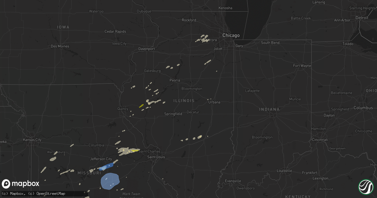
Hail Map in Illinois on May 20, 2022
Get this storm
May 20 map
$229
one time, instant access
Download today. No call, no setup
Keep the $229
Bought the map and want the full workflow? Apply the entire $229 to a subscription within 7 days. None of it is wasted.
Every map, not just this one
This buys you this map. Subscription and you get every map we run, in the markets you choose from a few cities to whole states to nationwide. Plus real-time alerts the moment a storm fires.
Contact data
Name, contact info, occupancy, even credit band for addresses in the footprint. You go from where it hit to who to call.
Become the source they trust
Unlimited branding weather history reports on demand. You already have the documented answer ready for the property owner, and you are the one who showed up with it.
Property data and RoofTrace estimates
Pull up any address you have got, its value and the exact code rules for that jurisdiction, straight from One Click Code. Then RoofTrace estimates the squares, pitch, and roof value, priced the way you price.
Storm reports in Illinois
Illinois
| Date | Description |
|---|---|
| 05/20/20228:00 AM CDT | Public report relayed by broadcast media. A gustnado removed a side panel from a metal building near alpha. Time estimated. A gustnado is a small... Brief... Surface-ba |
| 05/20/20225:45 AM CDT | Several 6-10in tree limbs broken off... One 8in tree trunk snapped. Power poles leaning over. |
| 05/20/20225:43 AM CDT | At 1042 PM CDT, a severe thunderstorm was located over St. Paul, moving east at 30 mph. HAZARD...60 mph wind gusts and quarter size hail. SOURCE...Radar indicated. IMPACT...Hail damage to vehicles is expected. Expect wind damage to roofs, siding, and trees. This severe thunderstorm will be near... St. Peters and Cottleville around 1055 PM CDT.Other locations in the path of this severe thunderstorm include St.Charles, Bridgeton and Orchard Farms.This includes Interstate 70 in Missouri between exits 216 and 229. This also includes First Missouri State Capitol Historic Site andPere Marquette State Park. |
All States Impacted by Hail Map on May 20, 2022
Cities Impacted by Hail Map on May 20, 2022
- Empire, MI
- Kewaunee, WI
- Menominee, MI
- Stephenson, MI
- Cedarville, MI
- Hinckley, IL
- Hebbronville, TX
- Seymour, IL
- Mahomet, IL
- Waterman, IL
- Deepwater, MO
- Lowry City, MO
- Osceola, MO
- Warsaw, MO
- Coffeen, IL
- Neptune, NJ
- Wentzville, MO
- Warrenton, MO
- Hermann, MO
- Wright City, MO
- Truesdale, MO
- Jonesburg, MO
- New Florence, MO
- Marthasville, MO
- High Hill, MO
- Rhineland, MO
- Foristell, MO
- Dixon, MO
- Bushnell, IL
- Washington, MO
- Johannesburg, MI
- Hawks, MI
- Traverse City, MI
- Posen, MI
- Mancelona, MI
- Elmira, MI
- Bellaire, MI
- Kewadin, MI
- Alden, MI
- East Jordan, MI
- Vanderbilt, MI
- Elk Rapids, MI
- Rogers City, MI
- Atlanta, MI
- Gaylord, MI
- Onaway, MI
- Presque Isle, MI
- Boyne Falls, MI
- Rapid City, MI
- Millersburg, MI
- Axson, GA
- Warrensburg, MO
- Centerview, MO
- Immokalee, FL
- Labelle, FL
- Wellsville, MO
- Montgomery City, MO
- Martinsburg, MO
- La Harpe, IL
- Dallas City, IL
- Modoc, IL
- Adair, IL
- Macomb, IL
- Elverson, PA
- Marshfield, MO
- Lakeview, MI
- Coral, MI
- Pierson, MI
- Howard City, MI
- Hollywood, FL
- Cuba, IL
- Ipava, IL
- Lewistown, IL
- Bardolph, IL
- Perry, OK
- Carthage, IL
- Chadwick, MO
- Garrison, MO
- Pompano Beach, FL
- Robesonia, PA
- Fleetwood, PA
- Temple, PA
- Oley, PA
- Douglassville, PA
- Reading, PA
- Bernville, PA
- Wernersville, PA
- Leesport, PA
- Boyertown, PA
- Birdsboro, PA
- Brooksville, FL
- Broken Arrow, OK
- Deal, NJ
- Vincentown, NJ
- Ochopee, FL
- Verona, MO
- Cassville, MO
- Monett, MO
- Purdy, MO
- Pickford, MI
- Hessel, MI
- Saint Ignace, MI
- Mount Pleasant, MI
- Ellison Bay, WI
- Washington Island, WI
- Baileys Harbor, WI
- Sister Bay, WI
- Rushville, IL
- Beardstown, IL
- Eldon, MO
- Tuscumbia, MO
- Pembroke, GA
- Douglas, GA
- Northport, MI
- Denmark, WI
- Green Bay, WI
- Luxemburg, WI
- Mackinac Island, MI
- Curryville, MO
- Plano, IL
- Sugar Grove, IL
- Big Rock, IL
- Yorkville, IL
- Aurora, IL
- Bristol, IL
- Sandwich, IL
- Kinderhook, IL
- Chatsworth, NJ
- Chamois, MO
- Linn, MO
- Morrison, MO
- Clifton, IL
- Broxton, GA
- Chandlerville, IL
- Bath, IL
- Mount Sterling, IL
- Versailles, IL
- Bristow, OK
- Mannford, OK
- Bingham, IL
- Ramsey, IL
- Mackinaw City, MI
- Pearson, GA
- South Bend, IN
- Green Ridge, MO
- La Monte, MO
- Fort Lauderdale, FL
- Pembroke Pines, FL
- Clinton, MO
- Edwards, MO
- Lincoln, MO
- Edmond, OK
- Oklahoma City, OK
- Colcord, OK
- Wauchula, FL
- Fort Meade, FL
- Leasburg, MO
- Maple Shade, NJ
- Jasper, FL
- Tahlequah, OK
- Hulbert, OK
- Hillman, MI
- Parkersburg, IA
- Perkiomenville, PA
- Mohnton, PA
- Zieglerville, PA
- Frederick, PA
- Green Lane, PA
- Pottstown, PA
- Gilbertsville, PA
- Morgantown, PA
- Harleysville, PA
- Schwenksville, PA
- Telford, PA
- Liberty, IL
- Salina, OK
- Jay, OK
- Algoma, WI
- Saint Louis, MI
- Midland, MI
- Breckenridge, MI
- Shepherd, MI
- Cedar, MI
- Maple City, MI
- Wentworth, MO
- Riverdale, MI
- Vestaburg, MI
- Hennessey, OK
- Dover, OK
- Sturgeon Bay, WI
- Egg Harbor, WI
- Vermont, IL
- Selma, AL
- Tyler, AL
- Chilhowee, MO
- Leeton, MO
- Blairstown, MO
- Fort Pierce, FL
- Jensen Beach, FL
- Casco, WI
- New Franken, WI
- Forestville, WI
- Levering, MI
- Carp Lake, MI
- Harbor Springs, MI
- Oshkosh, WI
- Van Dyne, WI
- Henry, IL
- Sparland, IL
- Media, PA
- Camden, NJ
- Merchantville, NJ
- Pennsauken, NJ
- Darby, PA
- Haddon Heights, NJ
- Blackwood, NJ
- Magnolia, NJ
- Brookhaven, PA
- Collingswood, NJ
- Morton, PA
- Westville, NJ
- Gibbsboro, NJ
- Marcus Hook, PA
- Essington, PA
- Philadelphia, PA
- Woodlyn, PA
- Thorofare, NJ
- Wallingford, PA
- Gloucester City, NJ
- Hockessin, DE
- Sharon Hill, PA
- Crum Lynne, PA
- Haddonfield, NJ
- Marlton, NJ
- Riverside, NJ
- Claymont, DE
- Folcroft, PA
- Chester, PA
- Barrington, NJ
- Voorhees, NJ
- Aston, PA
- Chadds Ford, PA
- Thornton, PA
- Glenolden, PA
- Wilmington, DE
- Chester Heights, PA
- Somerdale, NJ
- Norwood, PA
- Riverton, NJ
- Prospect Park, PA
- Swarthmore, PA
- Cherry Hill, NJ
- Oaklyn, NJ
- Bellmawr, NJ
- Holmes, PA
- National Park, NJ
- Glendora, NJ
- Glen Mills, PA
- Folsom, PA
- Runnemede, NJ
- Mount Ephraim, NJ
- Audubon, NJ
- Moorestown, NJ
- Garnet Valley, PA
- Ridley Park, PA
- Lawnside, NJ
- Medford, NJ
- Champaign, IL
- Niangua, MO
- Wyoming, IL
- Speer, IL
- Muskegon, MI
- Altamont, IL
- Stewardson, IL
- Shumway, IL
- Beecher City, IL
- Toulon, IL
- North Liberty, IN
- Walkerton, IN
- Bland, MO
- Barry, IL
- Pryor, OK
- Arkansas City, KS
- Garber, OK
- Billings, OK
- Inola, OK
- South Greenfield, MO
- Lockwood, MO
- York Springs, PA
- East Berlin, PA
- York, PA
- Dover, PA
- Thomasville, PA
- Spring Grove, PA
- Eugene, MO
- Vandalia, MO
- Galena, MO
- Sigel, IL
- Teutopolis, IL
- Claxton, GA
- Avon, IL
- Prairie City, IL
- Earlville, IL
- Ava, MO
- Seymour, MO
- Marshall, MO
- Nelson, MO
- Houstonia, MO
- Aurora, MO
- Crane, MO
- Lamar, MO
- Granby, MO
- Pierce City, MO
- Stark City, MO
- Dekalb, IL
- Maple Park, IL
- Freeburg, MO
- Plant City, FL
- Mazon, IL
- Gardner, IL
- Dwight, IL
- Zolfo Springs, FL
- Arcadia, FL
- Cabool, MO
- Mountain Grove, MO
- Oakwood, OK
- Ponca City, OK
- Rolla, MO
- Proctor, OK
- Homosassa, FL
- Reeds Spring, MO
- Walnut Shade, MO
- Elburn, IL
- Butler, MO
- Loxahatchee, FL
- Salem, MO
- Merion Station, PA
- Narberth, PA
- Havertown, PA
- Newtown Square, PA
- Villanova, PA
- Broomall, PA
- Haverford, PA
- Malvern, PA
- Bala Cynwyd, PA
- Berwyn, PA
- West Chester, PA
- Ardmore, PA
- Bryn Mawr, PA
- Wynnewood, PA
- Kinsman, IL
- Saint Thomas, MO
- Meta, MO
- Saint Elizabeth, MO
- Koeltztown, MO
- Argyle, MO
- Henley, MO
- Westphalia, MO
- Browning, IL
- Frederick, IL
- Oakford, IL
- Williamsport, IN
- Oldfield, MO
- Stella, MO
- Rocky Comfort, MO
- Wheaton, MO
- Fairview, MO
- Claremore, OK
- Chouteau, OK
- Davenport, FL
- Strafford, MO
- Waynesville, MO
- Longdale, OK
- Southard, OK
- Seiling, OK
- Okeene, OK
- Canton, OK
- Watonga, OK
- Albany, TX
- Billingsley, AL
- Schell City, MO
- Harwood, MO
- Newburg, MO
- Tunas, MO
- Autaugaville, AL
- Throckmorton, TX
- Festus, MO
- Everton, MO
- Greenfield, MO
- Coweta, OK
- Lebanon, MO
- Grovespring, MO
- Conway, MO
- Kansas, OK
- Westville, OK
- Watts, OK
- Macks Creek, MO
- Peggs, OK
- Locust Grove, OK
- Wagoner, OK
- Statenville, GA
- Lake Park, GA
- Palm City, FL
- Siloam Springs, AR
- Springfield, MO
- Brighton, MO
- Pleasant Hope, MO
- Republic, MO
- Billings, MO
- Rose, OK
- Prattville, AL
- Stuart, FL
- Hitchcock, OK
- Branson, MO
- Valrico, FL
- Dover, FL
- Seffner, FL
- Ozark, MO
- Chestnutridge, MO
- Forsyth, MO
- Afton, MI
- Central Lake, MI
- Wolverine, MI
- Honor, MI
- Glen Arbor, MI
- Lake Leelanau, MI
- Denver, PA
- Reinholds, PA
- Ephrata, PA
- Landisville, PA
- Akron, PA
- Adamstown, PA
- Maytown, PA
- Manheim, PA
- Lititz, PA
- Columbia, PA
- Mount Joy, PA
- Stevens, PA
- Marietta, PA
- Line Lexington, PA
- Spring City, PA
- Terre Hill, PA
- Sellersville, PA
- New Holland, PA
- Royersford, PA
- Collegeville, PA
- Chalfont, PA
- Bird In Hand, PA
- Leola, PA
- Hilltown, PA
- Doylestown, PA
- Perkasie, PA
- Narvon, PA
- Warrington, PA
- Souderton, PA
- Furlong, PA
- Hatfield, PA
- East Earl, PA
- New Hope, PA
- Shavertown, PA
- Olyphant, PA
- Waymart, PA
- Jessup, PA
- Moosic, PA
- Prompton, PA
- Peckville, PA
- Kingston, PA
- Taylor, PA
- Jermyn, PA
- Wyoming, PA
- Honesdale, PA
- Carbondale, PA
- Duryea, PA
- Scranton, PA
- Archbald, PA
- Plymouth, PA
- Pittston, PA
- Luzerne, PA
- Moscow, PA
- Wilkes Barre, PA
- Old Forge, PA
- Midlothian, MD
- Flintstone, MD
- Mount Savage, MD
- Frostburg, MD
- Cumberland, MD
- Ridgeley, WV
- Port Saint Lucie, FL
- Jupiter, FL
- Indiantown, FL
- Timewell, IL
- Hartshorn, MO
- Mansfield, MO
- Elk Creek, MO
- Hartville, MO
- Huggins, MO
- Eunice, MO
- Graff, MO
- Plato, MO
- Summersville, MO
- Solo, MO
- Macomb, MO
- Licking, MO
- Yukon, MO
- Norwood, MO
- Houston, MO
- Raymondville, MO
- Success, MO
- Bucyrus, MO
- Duke, MO
- Belle, MO
- Crocker, MO
- Saint James, MO
- Devils Elbow, MO
- Fort Leonard Wood, MO
- Saint Robert, MO
- Vichy, MO
- Brinktown, MO
- Edgar Springs, MO
- Vienna, MO
- Jerome, MO
- Bechtelsville, PA
- Barto, PA
- Blandon, PA
- Springfield, PA
- Clifton Heights, PA
- Drexel Hill, PA
- Lansdowne, PA


