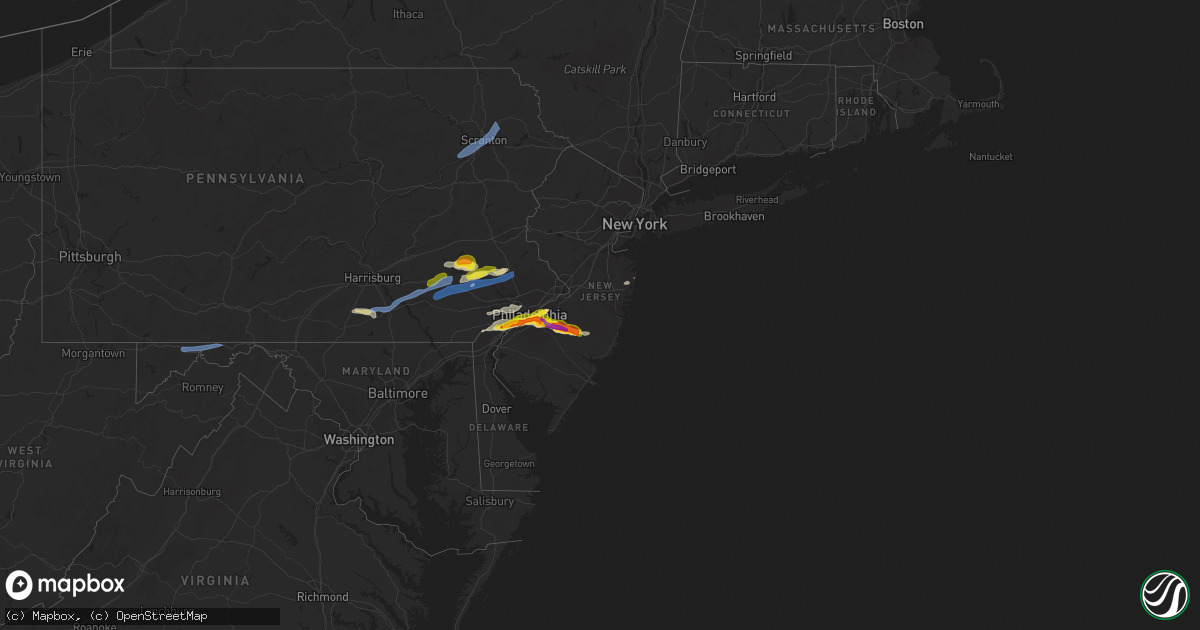
Hail Map in New Jersey on May 20, 2022
Get this storm
May 20 map
$229
one time, instant access
Download today. No call, no setup
Keep the $229
Bought the map and want the full workflow? Apply the entire $229 to a subscription within 7 days. None of it is wasted.
Every map, not just this one
This buys you this map. Subscription and you get every map we run, in the markets you choose from a few cities to whole states to nationwide. Plus real-time alerts the moment a storm fires.
Contact data
Name, contact info, occupancy, even credit band for addresses in the footprint. You go from where it hit to who to call.
Become the source they trust
Unlimited branding weather history reports on demand. You already have the documented answer ready for the property owner, and you are the one who showed up with it.
Property data and RoofTrace estimates
Pull up any address you have got, its value and the exact code rules for that jurisdiction, straight from One Click Code. Then RoofTrace estimates the squares, pitch, and roof value, priced the way you price.
Storm reports in New Jersey
New Jersey
| Date | Description |
|---|---|
| 05/20/20224:25 PM CDT | Picture via social media. Time estimated via radar. |
| 05/20/20224:12 PM CDT | Picture via social media. Time estimated via radar. |
| 05/20/20224:12 PM CDT | Time estimated from radar. |
| 05/20/20224:11 PM CDT | Multiple trees down in a yard... One of which crashed through a fence. Pictures via social media. |
| 05/20/20224:10 PM CDT | Three downed telephone poles along route 35 in hazlet near keyport. Time estimated from radar. |
| 05/20/20224:05 PM CDT | Shamong. Social media picture and measurements. Multiple 2 inch hailstones with several 1-2 inch hailstones. Along medford/shamong border on atsion road. |
| 05/20/20224:05 PM CDT | Corrects time from previous hail report from 3 sse medford lakes. Corrects previous hail report from 3 sse medford lakes. Report from mping: ping pong ball |
| 05/20/20223:55 PM CDT | Report from mping: quarter |
| 05/20/20223:52 PM CDT | Time estimated from radar. |
| 05/20/20223:47 PM CDT | Time estimated from radar. |
| 05/20/20223:45 PM CDT | Edit for correct time. |
| 05/20/20223:45 PM CDT | A local report indicates 1.50 inch wind near EVESHAM TWP |
| 05/20/20223:43 PM CDT | Report from mping: quarter |
| 05/20/20223:42 PM CDT | Time estimated from radar. |
| 05/20/20223:42 PM CDT | Picture via social media. Time estimated via radar. |
| 05/20/20223:40 PM CDT | Half dollar sized hail in voorhees. Time estimated from radar. |
| 05/20/20223:40 PM CDT | Social media image. Time estimated via radar. |
| 05/20/20223:40 PM CDT | Time estimated from radar. |
| 05/20/20223:37 PM CDT | Picture via social media. Time estimated via radar. |
| 05/20/20223:37 PM CDT | Corrects previous hail report from cherry hill twp. Via social media picture with measurements. Time estimated from radar. Edit for correct time. |
| 05/20/20223:30 PM CDT | Time estimated from radar. |
| 05/20/20223:27 PM CDT | Time estimated from radar. |
| 05/20/20223:07 PM CDT | Via social media picture with measurements. Time estimated from radar. |
| 05/20/20223:05 PM CDT | Corrects previous hail report from 3 sse medford lakes. Report from mping: ping pong ball |
| 05/20/20223:05 PM CDT | A local report indicates 1.25 inch wind near MARLTON |
| 05/20/202212:54 AM CDT | At 553 PM EDT, a severe thunderstorm was located over Brookville, or 15 miles southwest of Toms River, moving east at 35 mph. This storm has a history of producing hail up to ping pong ball size within the last hour. HAZARD...Ping pong ball size hail and 60 mph wind gusts. SOURCE...Public. IMPACT...People and animals outdoors will be injured. Expect hail damage to roofs, siding, windows, and vehicles. Wind damage to roofs, siding, trees, and power lines is possible. Locations impacted include... Barnegat, Beachwood, Seaside Heights, Brookville, Warren Grove, Bamber Lake, Ocean Acres and Waretown.This includes Garden State Parkway between mile markers 65 and 79. |
| 05/20/202212:20 AM CDT | At 519 PM EDT, severe thunderstorms were located along a line extending from near Keansburg to near Lincroft to near Freewood Acres, moving east at 35 mph. HAZARD...60 mph wind gusts and quarter size hail. SOURCE...Trained weather spotters. IMPACT...Minor damage to vehicles is possible. Wind damage to roofs, siding, trees, and power lines is possible. Locations impacted include... Long Branch, Asbury Park, Sandy Hook, Lakewood, Middletown, Howell, Tinton Falls, Holmdel, Red Bank, Manasquan, Highlands, Point Pleasant Beach, Farmingdale, Mantoloking, Allenwood, East Freehold, Cassville, Adelphia, Vista Center and Elberon.This includes the following highways... Interstate 195 in New Jersey between mile markers 20 and 34. Garden State Parkway between mile markers 91 and 117. |
| 05/20/202212:11 AM CDT | At 509 PM EDT, a severe thunderstorm was located over Tabernacle, or 21 miles east of Gloucester City, moving east at 25 mph. HAZARD...Two inch hail and 60 mph wind gusts. SOURCE...Trained weather spotters. At 437 PM EDT, two and a half inch diameter hail was reported in Cherry Hill. IMPACT...People and animals outdoors will be injured. Expect hail damage to roofs, siding, windows, and vehicles. Wind damage to roofs, siding, trees, and power lines is possible. Locations impacted include... Medford, Tabernacle, Shamong, Tuckerton, Presidential Lakes Estates, Atco, Wharton State Forest, Bamber Lake, Atsion, Brookville, Warren Grove, Bass River State Forest, Leisuretowne, Chatsworth, Old Halfway, Penn State Forest, Medford Lakes and Ocean Acres.This includes Garden State Parkway between mile markers 55 and 60. |
| 05/19/202211:33 PM CDT | At 433 PM EDT, a severe thunderstorm was located over Marlton, or 9 miles east of Camden, moving east at 30 mph. HAZARD...60 mph wind gusts and quarter size hail. SOURCE...Radar indicated. IMPACT...Minor damage to vehicles is possible. Wind damage to roofs, siding, trees, and power lines is possible. Locations impacted include... Cherry Hill, Evesham, Mount Laurel, Voorhees, Medford, Lindenwold, Lumberton, Bellmawr, Mount Holly, Berlin, Tabernacle, Shamong, Magnolia, Presidential Lakes Estates, Pemberton, Wrightstown, Barclay-Kingston, Marlton, Leisuretowne and Wharton State Forest.This includes the following highways... New Jersey Turnpike between exits 3 and 4. Interstate 295 in New Jersey between mile markers 29 and 43. |
| 05/19/202210:41 PM CDT | At 340 PM EDT, severe thunderstorms were located along a line extending from near Emmaus to near Green Lane to Trappe, moving east at 50 mph. HAZARD...70 mph wind gusts and quarter size hail. SOURCE...Radar indicated. IMPACT...Minor damage to vehicles is possible. Expect considerable tree damage. Wind damage is also likely to mobile homes, roofs, and outbuildings. Locations impacted include... Allentown, Trenton, Bethlehem, Ewing, Lansdale, Princeton, Emmaus, Quakertown, Perkasie, Doylestown, Byram, Souderton, Bedminster, Hellertown, Flemington, Chalfont, Tinicum, High Bridge, Hatfield and East Greenville.This includes the following highways... Northeast Extension between mile markers 28 and 55. Interstate 78 in Pennsylvania between mile markers 56 and 71. Interstate 78 in New Jersey near mile marker 2, and between milemarkers 7 and 25. Interstate 295 in New Jersey between mile markers 64 and 76. |
| 05/19/202210:25 PM CDT | At 324 PM EDT, severe thunderstorms were located along a line extending from Arrowhead Lake to near Beltzville State Park to near Wanamakers, moving northeast at 40 mph. HAZARD...60 mph wind gusts and quarter size hail. SOURCE...Radar indicated. IMPACT...Minor damage to vehicles is possible. Wind damage to roofs, siding, trees, and power lines is possible. Locations impacted include... Allentown, Easton, Lehighton, Mount Pocono, Bethlehem, Forks, Northampton, East Stroudsburg, Tobyhanna, Wilson, Hellertown, Nazareth, Palmerton, Bangor, Jim Thorpe, Slatington, Pen Argyl, Wind Gap, Bath and Walnutport.This includes the following highways... Northeast Extension between mile markers 56 and 95. Interstate 78 in Pennsylvania between mile markers 39 and 55, andbetween mile markers 65 and 76. Interstate 80 in Pennsylvania between mile markers 280 and 314. Interstate 80 in New Jersey near mile marker 3. Interstate 380 in Pennsylvania between mile markers 0 and 13. |
| 05/19/20229:27 PM CDT | At 227 PM EDT, a severe thunderstorm was located over Ashland, or 8 miles northwest of Wilmington, moving northeast at 25 mph. HAZARD...60 mph wind gusts and nickel size hail. SOURCE...Radar indicated. IMPACT...Damage to roofs, siding, trees, and power lines is possible. Locations impacted include... Philadelphia, Wilmington, Chester, Yeadon, Westtown, Conshohocken, Folcroft, Swarthmore, Elsmere, Paulsboro, Kennett Square, Westville, Narberth, National Park, East Lansdowne, Brooklawn, Arden, Darby Township, Cheyney and Morris Park.This includes the following highways... Interstate 95 in Pennsylvania between mile markers 0 and 19. Interstate 95 in Delaware between mile markers 15 and 23. Interstate 76 in Pennsylvania between mile markers 331 and 339, andbetween mile markers 341 and 351. Interstate 676 in Pennsylvania near mile marker 0. Interstate 476 in Pennsylvania between mile markers 0 and 18. |
All States Impacted by Hail Map on May 20, 2022
Cities Impacted by Hail Map on May 20, 2022
- Empire, MI
- Kewaunee, WI
- Menominee, MI
- Stephenson, MI
- Cedarville, MI
- Hinckley, IL
- Hebbronville, TX
- Seymour, IL
- Mahomet, IL
- Waterman, IL
- Deepwater, MO
- Lowry City, MO
- Osceola, MO
- Warsaw, MO
- Coffeen, IL
- Neptune, NJ
- Wentzville, MO
- Warrenton, MO
- Hermann, MO
- Wright City, MO
- Truesdale, MO
- Jonesburg, MO
- New Florence, MO
- Marthasville, MO
- High Hill, MO
- Rhineland, MO
- Foristell, MO
- Dixon, MO
- Bushnell, IL
- Washington, MO
- Johannesburg, MI
- Hawks, MI
- Traverse City, MI
- Posen, MI
- Mancelona, MI
- Elmira, MI
- Bellaire, MI
- Kewadin, MI
- Alden, MI
- East Jordan, MI
- Vanderbilt, MI
- Elk Rapids, MI
- Rogers City, MI
- Atlanta, MI
- Gaylord, MI
- Onaway, MI
- Presque Isle, MI
- Boyne Falls, MI
- Rapid City, MI
- Millersburg, MI
- Axson, GA
- Warrensburg, MO
- Centerview, MO
- Immokalee, FL
- Labelle, FL
- Wellsville, MO
- Montgomery City, MO
- Martinsburg, MO
- La Harpe, IL
- Dallas City, IL
- Modoc, IL
- Adair, IL
- Macomb, IL
- Elverson, PA
- Marshfield, MO
- Lakeview, MI
- Coral, MI
- Pierson, MI
- Howard City, MI
- Hollywood, FL
- Cuba, IL
- Ipava, IL
- Lewistown, IL
- Bardolph, IL
- Perry, OK
- Carthage, IL
- Chadwick, MO
- Garrison, MO
- Pompano Beach, FL
- Robesonia, PA
- Fleetwood, PA
- Temple, PA
- Oley, PA
- Douglassville, PA
- Reading, PA
- Bernville, PA
- Wernersville, PA
- Leesport, PA
- Boyertown, PA
- Birdsboro, PA
- Brooksville, FL
- Broken Arrow, OK
- Deal, NJ
- Vincentown, NJ
- Ochopee, FL
- Verona, MO
- Cassville, MO
- Monett, MO
- Purdy, MO
- Pickford, MI
- Hessel, MI
- Saint Ignace, MI
- Mount Pleasant, MI
- Ellison Bay, WI
- Washington Island, WI
- Baileys Harbor, WI
- Sister Bay, WI
- Rushville, IL
- Beardstown, IL
- Eldon, MO
- Tuscumbia, MO
- Pembroke, GA
- Douglas, GA
- Northport, MI
- Denmark, WI
- Green Bay, WI
- Luxemburg, WI
- Mackinac Island, MI
- Curryville, MO
- Plano, IL
- Sugar Grove, IL
- Big Rock, IL
- Yorkville, IL
- Aurora, IL
- Bristol, IL
- Sandwich, IL
- Kinderhook, IL
- Chatsworth, NJ
- Chamois, MO
- Linn, MO
- Morrison, MO
- Clifton, IL
- Broxton, GA
- Chandlerville, IL
- Bath, IL
- Mount Sterling, IL
- Versailles, IL
- Bristow, OK
- Mannford, OK
- Bingham, IL
- Ramsey, IL
- Mackinaw City, MI
- Pearson, GA
- South Bend, IN
- Green Ridge, MO
- La Monte, MO
- Fort Lauderdale, FL
- Pembroke Pines, FL
- Clinton, MO
- Edwards, MO
- Lincoln, MO
- Edmond, OK
- Oklahoma City, OK
- Colcord, OK
- Wauchula, FL
- Fort Meade, FL
- Leasburg, MO
- Maple Shade, NJ
- Jasper, FL
- Tahlequah, OK
- Hulbert, OK
- Hillman, MI
- Parkersburg, IA
- Perkiomenville, PA
- Mohnton, PA
- Zieglerville, PA
- Frederick, PA
- Green Lane, PA
- Pottstown, PA
- Gilbertsville, PA
- Morgantown, PA
- Harleysville, PA
- Schwenksville, PA
- Telford, PA
- Liberty, IL
- Salina, OK
- Jay, OK
- Algoma, WI
- Saint Louis, MI
- Midland, MI
- Breckenridge, MI
- Shepherd, MI
- Cedar, MI
- Maple City, MI
- Wentworth, MO
- Riverdale, MI
- Vestaburg, MI
- Hennessey, OK
- Dover, OK
- Sturgeon Bay, WI
- Egg Harbor, WI
- Vermont, IL
- Selma, AL
- Tyler, AL
- Chilhowee, MO
- Leeton, MO
- Blairstown, MO
- Fort Pierce, FL
- Jensen Beach, FL
- Casco, WI
- New Franken, WI
- Forestville, WI
- Levering, MI
- Carp Lake, MI
- Harbor Springs, MI
- Oshkosh, WI
- Van Dyne, WI
- Henry, IL
- Sparland, IL
- Media, PA
- Camden, NJ
- Merchantville, NJ
- Pennsauken, NJ
- Darby, PA
- Haddon Heights, NJ
- Blackwood, NJ
- Magnolia, NJ
- Brookhaven, PA
- Collingswood, NJ
- Morton, PA
- Westville, NJ
- Gibbsboro, NJ
- Marcus Hook, PA
- Essington, PA
- Philadelphia, PA
- Woodlyn, PA
- Thorofare, NJ
- Wallingford, PA
- Gloucester City, NJ
- Hockessin, DE
- Sharon Hill, PA
- Crum Lynne, PA
- Haddonfield, NJ
- Marlton, NJ
- Riverside, NJ
- Claymont, DE
- Folcroft, PA
- Chester, PA
- Barrington, NJ
- Voorhees, NJ
- Aston, PA
- Chadds Ford, PA
- Thornton, PA
- Glenolden, PA
- Wilmington, DE
- Chester Heights, PA
- Somerdale, NJ
- Norwood, PA
- Riverton, NJ
- Prospect Park, PA
- Swarthmore, PA
- Cherry Hill, NJ
- Oaklyn, NJ
- Bellmawr, NJ
- Holmes, PA
- National Park, NJ
- Glendora, NJ
- Glen Mills, PA
- Folsom, PA
- Runnemede, NJ
- Mount Ephraim, NJ
- Audubon, NJ
- Moorestown, NJ
- Garnet Valley, PA
- Ridley Park, PA
- Lawnside, NJ
- Medford, NJ
- Champaign, IL
- Niangua, MO
- Wyoming, IL
- Speer, IL
- Muskegon, MI
- Altamont, IL
- Stewardson, IL
- Shumway, IL
- Beecher City, IL
- Toulon, IL
- North Liberty, IN
- Walkerton, IN
- Bland, MO
- Barry, IL
- Pryor, OK
- Arkansas City, KS
- Garber, OK
- Billings, OK
- Inola, OK
- South Greenfield, MO
- Lockwood, MO
- York Springs, PA
- East Berlin, PA
- York, PA
- Dover, PA
- Thomasville, PA
- Spring Grove, PA
- Eugene, MO
- Vandalia, MO
- Galena, MO
- Sigel, IL
- Teutopolis, IL
- Claxton, GA
- Avon, IL
- Prairie City, IL
- Earlville, IL
- Ava, MO
- Seymour, MO
- Marshall, MO
- Nelson, MO
- Houstonia, MO
- Aurora, MO
- Crane, MO
- Lamar, MO
- Granby, MO
- Pierce City, MO
- Stark City, MO
- Dekalb, IL
- Maple Park, IL
- Freeburg, MO
- Plant City, FL
- Mazon, IL
- Gardner, IL
- Dwight, IL
- Zolfo Springs, FL
- Arcadia, FL
- Cabool, MO
- Mountain Grove, MO
- Oakwood, OK
- Ponca City, OK
- Rolla, MO
- Proctor, OK
- Homosassa, FL
- Reeds Spring, MO
- Walnut Shade, MO
- Elburn, IL
- Butler, MO
- Loxahatchee, FL
- Salem, MO
- Merion Station, PA
- Narberth, PA
- Havertown, PA
- Newtown Square, PA
- Villanova, PA
- Broomall, PA
- Haverford, PA
- Malvern, PA
- Bala Cynwyd, PA
- Berwyn, PA
- West Chester, PA
- Ardmore, PA
- Bryn Mawr, PA
- Wynnewood, PA
- Kinsman, IL
- Saint Thomas, MO
- Meta, MO
- Saint Elizabeth, MO
- Koeltztown, MO
- Argyle, MO
- Henley, MO
- Westphalia, MO
- Browning, IL
- Frederick, IL
- Oakford, IL
- Williamsport, IN
- Oldfield, MO
- Stella, MO
- Rocky Comfort, MO
- Wheaton, MO
- Fairview, MO
- Claremore, OK
- Chouteau, OK
- Davenport, FL
- Strafford, MO
- Waynesville, MO
- Longdale, OK
- Southard, OK
- Seiling, OK
- Okeene, OK
- Canton, OK
- Watonga, OK
- Albany, TX
- Billingsley, AL
- Schell City, MO
- Harwood, MO
- Newburg, MO
- Tunas, MO
- Autaugaville, AL
- Throckmorton, TX
- Festus, MO
- Everton, MO
- Greenfield, MO
- Coweta, OK
- Lebanon, MO
- Grovespring, MO
- Conway, MO
- Kansas, OK
- Westville, OK
- Watts, OK
- Macks Creek, MO
- Peggs, OK
- Locust Grove, OK
- Wagoner, OK
- Statenville, GA
- Lake Park, GA
- Palm City, FL
- Siloam Springs, AR
- Springfield, MO
- Brighton, MO
- Pleasant Hope, MO
- Republic, MO
- Billings, MO
- Rose, OK
- Prattville, AL
- Stuart, FL
- Hitchcock, OK
- Branson, MO
- Valrico, FL
- Dover, FL
- Seffner, FL
- Ozark, MO
- Chestnutridge, MO
- Forsyth, MO
- Afton, MI
- Central Lake, MI
- Wolverine, MI
- Honor, MI
- Glen Arbor, MI
- Lake Leelanau, MI
- Denver, PA
- Reinholds, PA
- Ephrata, PA
- Landisville, PA
- Akron, PA
- Adamstown, PA
- Maytown, PA
- Manheim, PA
- Lititz, PA
- Columbia, PA
- Mount Joy, PA
- Stevens, PA
- Marietta, PA
- Line Lexington, PA
- Spring City, PA
- Terre Hill, PA
- Sellersville, PA
- New Holland, PA
- Royersford, PA
- Collegeville, PA
- Chalfont, PA
- Bird In Hand, PA
- Leola, PA
- Hilltown, PA
- Doylestown, PA
- Perkasie, PA
- Narvon, PA
- Warrington, PA
- Souderton, PA
- Furlong, PA
- Hatfield, PA
- East Earl, PA
- New Hope, PA
- Shavertown, PA
- Olyphant, PA
- Waymart, PA
- Jessup, PA
- Moosic, PA
- Prompton, PA
- Peckville, PA
- Kingston, PA
- Taylor, PA
- Jermyn, PA
- Wyoming, PA
- Honesdale, PA
- Carbondale, PA
- Duryea, PA
- Scranton, PA
- Archbald, PA
- Plymouth, PA
- Pittston, PA
- Luzerne, PA
- Moscow, PA
- Wilkes Barre, PA
- Old Forge, PA
- Midlothian, MD
- Flintstone, MD
- Mount Savage, MD
- Frostburg, MD
- Cumberland, MD
- Ridgeley, WV
- Port Saint Lucie, FL
- Jupiter, FL
- Indiantown, FL
- Timewell, IL
- Hartshorn, MO
- Mansfield, MO
- Elk Creek, MO
- Hartville, MO
- Huggins, MO
- Eunice, MO
- Graff, MO
- Plato, MO
- Summersville, MO
- Solo, MO
- Macomb, MO
- Licking, MO
- Yukon, MO
- Norwood, MO
- Houston, MO
- Raymondville, MO
- Success, MO
- Bucyrus, MO
- Duke, MO
- Belle, MO
- Crocker, MO
- Saint James, MO
- Devils Elbow, MO
- Fort Leonard Wood, MO
- Saint Robert, MO
- Vichy, MO
- Brinktown, MO
- Edgar Springs, MO
- Vienna, MO
- Jerome, MO
- Bechtelsville, PA
- Barto, PA
- Blandon, PA
- Springfield, PA
- Clifton Heights, PA
- Drexel Hill, PA
- Lansdowne, PA


