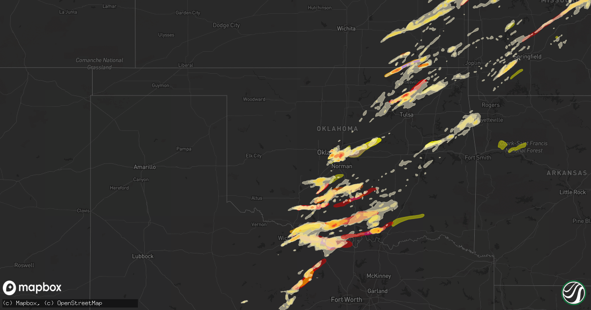
Hail Map in Oklahoma on May 20, 2013
Get this storm
May 20 map
$229
one time, instant access
Download today. No call, no setup
Keep the $229
Bought the map and want the full workflow? Apply the entire $229 to a subscription within 7 days. None of it is wasted.
Every map, not just this one
This buys you this map. Subscription and you get every map we run, in the markets you choose from a few cities to whole states to nationwide. Plus real-time alerts the moment a storm fires.
Contact data
Name, contact info, occupancy, even credit band for addresses in the footprint. You go from where it hit to who to call.
Become the source they trust
Unlimited branding weather history reports on demand. You already have the documented answer ready for the property owner, and you are the one who showed up with it.
Property data and RoofTrace estimates
Pull up any address you have got, its value and the exact code rules for that jurisdiction, straight from One Click Code. Then RoofTrace estimates the squares, pitch, and roof value, priced the way you price.
Storm reports in Oklahoma
Oklahoma
| Date | Description |
|---|---|
| 05/20/20136:39 PM CDT | Spotter reported tree branches down in area |
| 05/20/20136:36 PM CDT | Tornado reported by trained spotter and colocated with a strong radar circulation. Trees down on highway 62. Tornado may have continued to near the illinois river bridg |
| 05/20/20136:30 PM CDT | Damage to a diesel shop. Numerous power poles snapped. Semi trailers blown off the road. 50 to 60 foot tree also blocking a roadway 3 miles east of twin bridges likely |
| 05/20/20136:30 PM CDT | West facing garage doors and fence bowed in. About 10 bradford pear trees damaged with some completely snapped. Branches on large trees snapped. Heavy metal patio furni |
| 05/20/20136:00 PM CDT | Measured 66 mph wind gust at the vinita mesonet. |
| 05/20/20135:52 PM CDT | A local report indicates 1.00 inch wind near WAINWRIGHT |
| 05/20/20135:49 PM CDT | 60 to 65 mph winds reported by the checotah police department. |
| 05/20/20135:45 PM CDT | Em reports roof blown off of old gene autry gym. |
| 05/20/20135:43 PM CDT | A local report indicates 1.00 inch wind near 2 SSE TURNER FALLS |
| 05/20/20134:59 PM CDT | Large tree limbs downed |
| 05/20/20134:52 PM CDT | A local report indicates 1.75 inch wind near 6 W STRATFORD |
| 05/20/20134:50 PM CDT | A local report indicates 2.75 inch wind near AVANT |
| 05/20/20134:45 PM CDT | A local report indicates 2.50 inch wind near CORNISH |
| 05/20/20134:36 PM CDT | A local report indicates 1.75 inch wind near WHITEBEAD |
| 05/20/20134:35 PM CDT | Reported by oklahoma highway patrol |
| 05/20/20134:30 PM CDT | Reported by kwtv |
| 05/20/20134:15 PM CDT | A local report indicates 1.00 inch wind near WAURIKA |
| 05/20/20134:12 PM CDT | A local report indicates 2.00 inch wind near WILL ROGERS AIRPORT |
| 05/20/20133:56 PM CDT | Multiple spotters and broadcast media report a large tornado on the ground that first developed near avant and continued northeastward into washington county. A tornado |
| 05/20/20133:15 PM CDT | Softball and baseball hail observed 8n of herd |
| 05/20/20133:06 PM CDT | A local report indicates 2.50 inch wind near 3 NNW MOORE |
| 05/20/20132:28 PM CDT | A local report indicates 1.00 inch wind near WILL ROGERS AIRPORT |
| 05/20/20132:27 PM CDT | A local report indicates 3.25 inch wind near YUKON |
| 05/20/20132:02 PM CDT | A local report indicates 1.00 inch wind near 6 W DUNCAN |
| 05/20/20131:56 PM CDT | A local report indicates 1.00 inch wind near 1 S RUSH SPRINGS |
| 05/20/20131:54 PM CDT | A local report indicates 1.75 inch wind near 6 N MARLOW |
| 05/20/201312:30 PM CDT | A local report indicates 1.25 inch wind near ADA |
| 05/20/20135:50 AM CDT | A local report indicates 60 MPH wind near 2 NNW NINNEKAH |
| 05/20/20135:49 AM CDT | Trees and power lines down |
| 05/20/20135:46 AM CDT | A local report indicates 1.75 inch wind near NINNEKAH |
| 05/20/20135:26 AM CDT | Roof off of building by highway 277...blocking roadway. |
| 05/20/20135:25 AM CDT | A local report indicates 1.00 inch wind near CYRIL |
| 05/20/20135:20 AM CDT | Tree damage and powerlines down. |
| 05/20/20135:17 AM CDT | A local report indicates 77 MPH wind near 2 W CYRIL |
| 05/20/20134:00 AM CDT | A local report indicates 1.00 inch wind near 1 E PURCELL |
| 05/20/201312:30 AM CDT | A local report indicates 1.25 inch wind near ADA |
| 05/20/201312:26 AM CDT | A local report indicates 1.00 inch wind near ADA |
| 05/19/201311:34 PM CDT | From kswo |
| 05/19/201311:27 PM CDT | Public reported hail covering ground...dimes to quarters. |
| 05/19/201311:26 PM CDT | At stephens county fairgrounds |
| 05/19/201310:25 PM CDT | A local report indicates 1.75 inch wind near GERONIMO |
| 05/19/201310:25 PM CDT | A local report indicates 1.25 inch wind near 2 SW GERONIMO |
| 05/19/20139:58 PM CDT | At intersection of sh-22 and albert pike road |
| 05/19/20139:09 PM CDT | A local report indicates 2.75 inch wind near 4 S LITTLE CITY |
| 05/19/20139:08 PM CDT | 12 inch tree limbs downed. |
| 05/19/20139:00 PM CDT | Tree damage at clayton lake state park. |
| 05/19/20138:50 PM CDT | Law enforcement radio reported a tornado near cameron colocated with a strong radar circulation. It may have continued to the rock island vicinity. Emergency management |
| 05/19/20138:46 PM CDT | Nws survey indicated a ef-0 occurred between poteau and cameron. Time estimated by radar. Additional information to be determined. |
| 05/19/20138:41 PM CDT | Building downtown with its roof blown off. Numerous buildings have windows blown out. Numerous trees and power lines down. |
| 05/19/20138:41 PM CDT | Sustained 55 to 60 mph winds |
| 05/19/20138:41 PM CDT | Tree down along highway 101. |
| 05/19/20138:32 PM CDT | Report from law enforcement radio of a tornado between mccurtain and bokoshe colocated with a strong radar circulation. Broadcast media reported power flashes in the ar |
| 05/19/20138:24 PM CDT | A local report indicates 1.00 inch wind near MARIETTA |
| 05/19/20138:14 PM CDT | Trees and powerlines down in town. |
| 05/19/20138:05 PM CDT | A local report indicates 62 MPH wind near 7 WNW ARDMORE |
| 05/19/20138:00 PM CDT | Emergency management reports trees down and power line down in western durant. |
| 05/19/20137:55 PM CDT | Measured wind gust of 66 mph at the clayton mesonet |
| 05/19/20137:21 PM CDT | Trees down on homes and vehicles in town. |
All States Impacted by Hail Map on May 20, 2013
Cities Impacted by Hail Map on May 20, 2013
- Higbee, MO
- Madison, MO
- Clark, MO
- Moberly, MO
- Hampton, FL
- Gainesville, FL
- Waldo, FL
- Starke, FL
- Bowie, TX
- Chelsea, OK
- Caney, KS
- Copan, OK
- Howard City, MI
- Novinger, MO
- Greentop, MO
- Kirksville, MO
- Grand Rapids, MI
- Belding, MI
- Greenville, MI
- Ada, MI
- Lowell, MI
- Sedan, KS
- Perry, MO
- Stoutsville, MO
- Santa Fe, MO
- Fair Play, MO
- Fayette, MO
- Westville, OK
- Proctor, OK
- Crocker, MO
- Richland, MO
- Meeker, OK
- Mustang, OK
- Bethany, OK
- Choctaw, OK
- Mcloud, OK
- Wheatland, OK
- Harrah, OK
- Newalla, OK
- Oklahoma City, OK
- Jones, OK
- Newcastle, OK
- Wellston, OK
- Norman, OK
- Spencer, OK
- Bradenton, FL
- Talala, OK
- Ninnekah, OK
- Chickasha, OK
- Sullivan, MO
- Leslie, MO
- Beaufort, MO
- Harrisonville, MO
- Garden City, MO
- Ada, OK
- Lebanon, MO
- Windyville, MO
- Tunas, MO
- Eldridge, MO
- Port Charlotte, FL
- Venice, FL
- North Port, FL
- Williamsburg, MI
- Rapid City, MI
- Elk Rapids, MI
- Kewadin, MI
- Madill, OK
- Haslett, MI
- Owensville, MO
- Muenster, TX
- Saint Jo, TX
- Bland, MO
- Belle, MO
- Marlow, OK
- Rush Springs, OK
- Park Hill, OK
- Tahlequah, OK
- Carbon, TX
- Eastland, TX
- Rising Star, TX
- Cisco, TX
- Bartlesville, OK
- Wichita Falls, TX
- Maxwell, IA
- Cambridge, IA
- Bourbon, MO
- Gerald, MO
- New Haven, MO
- Rosebud, MO
- Saint James, MO
- Washington, MO
- Rolla, MO
- Cuba, MO
- Marthasville, MO
- Union, MO
- Vichy, MO
- Dansville, MI
- Williamston, MI
- Webberville, MI
- Newaygo, MI
- Mecosta, MI
- Barryton, MI
- Morley, MI
- White Cloud, MI
- Rodney, MI
- Big Rapids, MI
- Evart, MI
- Stanwood, MI
- Vinita, OK
- Queen City, MO
- Green Castle, MO
- Early, TX
- Purmela, TX
- Hamilton, TX
- Pottsville, TX
- Mullin, TX
- Gatesville, TX
- Brownwood, TX
- Sidney, TX
- Comanche, TX
- Goldthwaite, TX
- Jonesboro, TX
- Zephyr, TX
- May, TX
- Evant, TX
- Gustine, TX
- Blanket, TX
- Priddy, TX
- Sturgeon, MO
- Saint George, SC
- Bowman, SC
- Chico, TX
- Jacksboro, TX
- Northport, MI
- Foster, OK
- Elmore City, OK
- Laingsburg, MI
- Swoope, VA
- Rockford, MI
- Sasakwa, OK
- Rich Hill, MO
- Butler, MO
- Osceola, MO
- Deepwater, MO
- Rockville, MO
- Hume, MO
- Montrose, MO
- Appleton City, MO
- Clinton, MO
- Stonewall, OK
- Boyne City, MI
- Traverse City, MI
- Interlochen, MI
- Pawhuska, OK
- Duncan, OK
- Afton, IA
- Creston, IA
- Lorimor, IA
- Shannon City, IA
- Winterset, IA
- Macksburg, IA
- Comanche, OK
- Skiatook, OK
- Barnsdall, OK
- Ramona, OK
- Centralia, MO
- Beaverton, MI
- Edmore, MI
- Stratford, OK
- Lachine, MI
- De Leon, TX
- Bois D Arc, MO
- Fulton, MO
- Lutz, FL
- Dade City, FL
- Land O'Lakes, FL
- Wesley Chapel, FL
- San Antonio, FL
- Mason, MI
- Deland, FL
- Slater, MO
- Glasgow, MO
- Pilot Grove, MO
- Sedalia, MO
- Hughesville, MO
- New Franklin, MO
- Sweet Springs, MO
- Houstonia, MO
- Blackwater, MO
- Franklin, MO
- La Monte, MO
- Arrow Rock, MO
- Smithton, MO
- Gilliam, MO
- Nelson, MO
- Marshall, MO
- Davenport, FL
- Kissimmee, FL
- Lueders, TX
- Albany, TX
- Franklin, NC
- Sylva, NC
- Suttons Bay, MI
- Coffeyville, KS
- Springer, OK
- Ardmore, OK
- Brookfield, MO
- New Boston, MO
- Aurora, MO
- Marionville, MO
- Verona, MO
- Miami, OK
- Wyandotte, OK
- Clarksville, MI
- Saranac, MI
- Alto, MI
- Vienna, MO
- Dixon, MO
- Columbia, MO
- Auxvasse, MO
- Croswell, MI
- Welch, OK
- Holdenville, OK
- Rose City, MI
- West Branch, MI
- South Branch, MI
- Lupton, MI
- Fair Grove, MO
- Pleasant Hope, MO
- Springfield, MO
- Curran, MI
- Hubbard Lake, MI
- Barton City, MI
- Cement, OK
- Alex, OK
- Blanchard, OK
- Wapanucka, OK
- Milburn, OK
- Tupelo, OK
- Iberia, MO
- Saint Elizabeth, MO
- Tuscumbia, MO
- Flushing, MI
- Montrose, MI
- Mexico, MO
- Eufaula, OK
- Independence, KS
- De Leon Springs, FL
- Wilson, OK
- Severy, KS
- Howard, KS
- Fall River, KS
- Piedmont, KS
- Gladwin, MI
- Alger, MI
- Glencoe, OK
- Stillwater, OK
- Windermere, FL
- Orlando, FL
- Winter Garden, FL
- Hawthorne, FL
- Granby, MO
- Pierce City, MO
- Carthage, MO
- Sarcoxie, MO
- Nocona, TX
- Cullowhee, NC
- Decker, MI
- Apopka, FL
- Altamonte Springs, FL
- Ocoee, FL
- Lake Mary, FL
- Longwood, FL
- Brinktown, MO
- Brumley, MO
- Meta, MO
- Newburg, MO
- Argyle, MO
- Stoutland, MO
- Long Lane, MO
- Montreal, MO
- Buffalo, MO
- Ubly, MI
- East Jordan, MI
- Boyne Falls, MI
- Kalkaska, MI
- Fife Lake, MI
- Belmont, MI
- Wynnewood, OK
- Edmond, OK
- Parrish, FL
- Myakka City, FL
- Lamar, MO
- Liberal, MO
- Fort Gibson, OK
- Hulbert, OK
- Reed City, MI
- Paris, MI
- Hersey, MI
- Mound City, KS
- Blairstown, MO
- Adrian, MO
- Warrensburg, MO
- Foster, MO
- Creighton, MO
- La Cygne, KS
- Centerview, MO
- Chilhowee, MO
- Amsterdam, MO
- Amoret, MO
- Archie, MO
- Holden, MO
- Pleasanton, KS
- Leon, OK
- Coalgate, OK
- Republic, MO
- Westphalia, KS
- Garnett, KS
- Welda, KS
- Braggs, OK
- Muskogee, OK
- Morriston, FL
- Inglis, FL
- Bronson, FL
- Sumner, MI
- Van Meter, IA
- Waukee, IA
- Dallas Center, IA
- Adel, IA
- De Soto, IA
- Breckenridge, TX
- Moran, KS
- La Harpe, KS
- Yates Center, KS
- Toronto, KS
- Piqua, KS
- Buffalo, KS
- Iola, KS
- Bronson, KS
- Fredonia, KS
- Humboldt, KS
- Kingston, OK
- Willard, MO
- Archer, FL
- Micanopy, FL
- Tishomingo, OK
- Mill Creek, OK
- Concordia, MO
- Fort McCoy, FL
- Jefferson City, MO
- Centertown, MO
- Hartsburg, MO
- Polk City, IA
- Slater, IA
- Alleman, IA
- Huxley, IA
- Lincoln, AR
- Summers, AR
- Ochelata, OK
- Wright City, MO
- Paoli, OK
- Byars, OK
- Maysville, OK
- Pauls Valley, OK
- Lindsay, OK
- Wayne, OK
- Calhoun, MO
- Earleton, FL
- Knob Noster, MO
- Whiteman Air Force Base, MO
- Sparta, MI
- Sand Lake, MI
- Cedar Springs, MI
- Comstock Park, MI
- Ringgold, TX
- Big Cabin, OK
- Elk City, KS
- Riverdale, MI
- Elwell, MI
- Henrietta, TX
- South Boardman, MI
- Au Gres, MI
- Turner, MI
- Owosso, MI
- Corunna, MI
- Carson City, MI
- Perrinton, MI
- Hubbardston, MI
- Middleton, MI
- Prescott, KS
- Urich, MO
- East Lynne, MO
- Blue Mound, KS
- Otterville, MO
- Holliday, MO
- Bunceton, MO
- Paola, KS
- Fontana, KS
- Peculiar, MO
- Pleasant Hill, MO
- Paris, MO
- Centerville, KS
- Louisburg, KS
- Dalton, MO
- Parker, KS
- Boonville, MO
- Drexel, MO
- Colony, KS
- Salisbury, MO
- Leeton, MO
- Grenola, KS
- Freeman, MO
- Kincaid, KS
- Kingsville, MO
- Keytesville, MO
- Cleveland, MO
- Flint, MI
- Burton, MI
- Melvin, MI
- Peck, MI
- Yale, MI
- Brown City, MI
- Baring, MO
- Rutledge, MO
- Memphis, MO
- Edina, MO
- Nevada, IA
- Arbela, MO
- Luray, MO
- Cherryvale, KS
- Liberty, KS
- Bowling Green, FL
- Fort Meade, FL
- Ringling, OK
- Ankeny, IA
- Bondurant, IA
- Des Moines, IA
- Geronimo, OK
- Walters, OK
- Waurika, OK
- Holliday, TX
- Byers, TX
- Randlett, OK
- Temple, OK
- Sheppard Afb, TX
- Ryan, OK
- Healdton, OK
- Montague, TX
- Iowa Park, TX
- Terral, OK
- Petrolia, TX
- Lone Grove, OK
- Bellevue, TX
- Burneyville, OK
- Miami, MO
- Hillman, MI
- Tampa, FL
- Smoaks, SC
- Walterboro, SC
- Reevesville, SC
- Mio, MI
- Fairview, MI
- Orange City, FL
- Sheridan, MI
- Fenwick, MI
- Wolverine, MI
- Lexington, OK
- Rocheport, MO
- Eagle, MI
- Grand Ledge, MI
- Elmira, MI
- Collinsville, OK
- Thompson, MO
- Lohman, MO
- Russellville, MO
- Elkhart, IA
- Ranger, TX
- Caddo, TX
- Strawn, TX
- Comins, MI
- Owendale, MI
- Staunton, VA
- Ocala, FL
- Wooldridge, MO
- Umatilla, FL
- Leesburg, FL
- Ocklawaha, FL
- Meigs, GA
- Oologah, OK
- Siloam Springs, AR
- Saint Johns, MI
- Half Way, MO
- Grimes, IA
- Earlham, IA
- Clive, IA
- Johnston, IA
- Booneville, IA
- West Des Moines, IA
- Urbandale, IA
- Collins, IA
- Granger, IA
- Lenox, IA
- Colo, IA
- Diagonal, IA
- Williamstown, MO
- Newark, MO
- Kahoka, MO
- La Belle, MO
- Knox City, MO
- Watts, OK
- Checotah, OK
- Henryetta, OK
- Oktaha, OK
- Howell, MI
- Fowlerville, MI
- Hallsville, MO
- Prairie Grove, AR
- Fayetteville, AR
- Tustin, MI
- Fairland, OK
- Herron, MI
- Bluejacket, OK
- Stigler, OK
- Grawn, MI
- Mead, OK
- Cherokee, KS
- McCune, KS
- Valrico, FL
- Dover, FL
- Brandon, FL
- Seffner, FL
- Citra, FL
- Homosassa, FL
- Brooksville, FL
- Leslie, AR
- Harrisburg, MO
- Terlton, OK
- Cleveland, OK
- Pierson, FL
- Belle Glade, FL
- Vicksburg, MI
- Lake City, FL
- Clio, MI
- Everton, MO
- Miller, MO
- Jennings, OK
- Vera, OK
- Delaware, OK
- Claremore, OK
- Hominy, OK
- Prue, OK
- Yale, OK
- Osage, OK
- Sperry, OK
- Tulsa, OK
- Owasso, OK
- Maramec, OK
- Nowata, OK
- Cookson, OK
- Arcadia, FL
- Mannsville, OK
- Sulphur, OK
- Walnut Grove, MO
- Aldrich, MO
- Chandler, OK
- Davenport, OK
- Stroud, OK
- Eustis, FL
- Purdy, MO
- Monett, MO
- Lenapah, OK
- Lake, MI
- Farwell, MI
- Sears, MI
- Jasper, MO
- Oronogo, MO
- Hermann, MO
- Billings, MO
- Mount Vernon, MO
- Washburn, MO
- Faxon, OK
- Roff, OK
- Stilwell, OK
- Tyro, KS
- Wann, OK
- Lake City, MI
- Wheaton, MO
- Clare, MI
- Harrison, MI
- Chippewa Lake, MI
- Ames, IA
- Allen, OK
- Anthony, FL
- Silver Springs, FL
- Meridian, OK
- Erie, KS
- Stark, KS
- Shelbina, MO
- Conway, MO
- Grovespring, MO
- Niangua, MO
- Kingdom City, MO
- Stuart, OK
- S Coffeyville, OK
- Oswego, KS
- Perrin, TX
- Goshen, VA
- Grandville, MI
- Byron Center, MI
- Wyoming, MI
- Tuttle, OK
- Thonotosassa, FL
- Saint Patrick, MO
- Lewistown, MO
- Vermilion, OH
- Inverness, FL
- Lecanto, FL
- Mount Pleasant, MI
- Weidman, MI
- Remus, MI
- Sand Springs, OK
- Metter, GA
- Wynona, OK
- Fairfax, OK
- Pawnee, OK
- Bellaire, MI
- Alden, MI
- Mancelona, MI
- Mindenmines, MO
- Windsor, MO
- Graham, TX
- Graford, TX
- Bryson, TX
- Bolivar, MO
- Morrisville, MO
- Sylvania, GA
- Cyril, OK
- Apache, OK
- Bradley, OK
- Purcell, OK
- Fletcher, OK
- Anadarko, OK
- Brashear, MO
- Hurdland, MO
- Asbury, MO
- Columbus, KS
- Pittsburg, KS
- Weir, KS
- Scammon, KS
- Alden, IA
- Dows, IA
- Popejoy, IA
- Hampton, IA
- Latimer, IA
- McBain, MI
- Marion, MI
- Exeter, MO
- Rogers City, MI
- West Augusta, VA
- Lane, KS
- Yukon, OK
- Vestaburg, MI
- Chanute, KS
- Jamestown, MO
- Fort White, FL
- Ithaca, MI
- Fowler, MI
- Statesboro, GA
- High Springs, FL
- Green Ridge, MO
- Durant, OK
- Versailles, IL
- Chambersburg, IL
- Mcalester, OK
- Stark City, MO
- Altamont, KS
- Edna, KS
- Parsons, KS
- Mound Valley, KS
- Lawton, OK
- Humansville, MO
- Central Lake, MI
- Tiger, GA
- Clayton, GA
- Neodesha, KS
- Naples, FL
- Highlands, NC
- Cashiers, NC
- Abilene, TX
- Sanderson, FL
- Stockton, MO
- Petoskey, MI
- Dustin, OK
- Berger, MO
- Marlette, MI
- Lockwood, MO
- Jerico Springs, MO
- Foristell, MO
- Mingo, IA
- Grant, MI
- Pierson, MI
- Kent City, MI
- Sorrento, FL
- Sanford, FL
- Lake Toxaway, NC
- Stotts City, MO
- Kelley, IA
- Madrid, IA
- Lorain, OH
- Ashland, MO
- Greenville, VA
- Caledonia, MI
- Atoka, OK
- Lane, OK
- Six Lakes, MI
- Wauchula, FL
- Bartow, FL
- Uniontown, KS
- Ash Grove, MO
- Alexandria, MO
- Novelty, MO
- Wentworth, MO
- Scotland, TX
- Porum, OK
- Register, GA
- Chattanooga, OK
- Jermyn, TX
- Dewitt, MI
- Lansing, MI
- Manton, MI
- Houghton Lake, MI
- Stella, MO
- Neosho, MO
- Mount Dora, FL
- Mountain Rest, SC
- Wanette, OK
- Canadian, OK
- Lebanon, OK
- Marietta, OK
- Greenfield, MO
- Dadeville, MO
- Linn, MO
- Trufant, MI
- Hartville, MO
- Falcon, MO
- Decorah, IA
- Ossian, IA
- Spring Hill, FL
- Girard, KS
- Cassville, MO
- Roosevelt, OK
- Hale, MI
- Armstrong, MO
- Reeds, MO
- Hudsonville, MI
- Bath, MI
- Ulman, MO
- Havana, KS
- Peru, KS
- Cedar Vale, KS
- Balsam Grove, NC
- Rosman, NC
- Houghton Lake Heights, MI
- Asher, OK
- Konawa, OK
- Dahlonega, GA
- Centrahoma, OK
- Middlebrook, VA
- Fairgrove, MI
- Capac, MI
- Bucyrus, KS
- Diamond, MO
- Camilla, GA
- Doerun, GA
- Sale City, GA
- Depew, OK
- Thayer, KS
- Dunnellon, FL
- Fort Scott, KS
- Zephyrhills, FL
- Gainesville, TX
- Coleman, OK
- Overbrook, OK
- Davis, OK
- Seneca, MO
- Calmar, IA
- Welling, OK
- Council Hill, OK
- Warner, OK
- Clifton, TX
- Valley Mills, TX
- Marceline, MO
- North Star, MI
- McRae Helena, GA
- Weleetka, OK
- Altoona, KS
- Williston, FL
- Osawatomie, KS
- Gorin, MO
- Stanton, MI
- Spiro, OK
- Pocola, OK
- Cameron, OK
- Kenefic, OK
- Sparks, OK
- Scotts, MI
- Swartz Creek, MI
- Cass City, MI
- Carnegie, OK
- Mountain View, OK
- Alpena, MI
- Brighton, MO
- Altoona, IA
- Monroe City, MO
- Benedict, KS
- Arcola, MO
- Kirkman, IA
- Ionia, MI
- Grand Island, FL
- Roseville, IL
- Smithshire, IL
- Swaledale, IA
- New Bloomfield, MO
- Bowling Green, MO
- Cushing, OK
- Glennie, MI
- Englewood, FL
- Mulberry, KS
- Bronaugh, MO
- Sandusky, MI
- Snover, MI
- Dewey, OK
- Niotaze, KS
- Dearing, KS
- Galesburg, KS
- Montgomery City, MO
- Williamsburg, MO
- Hector, AR
- Pelsor, AR
- Gaines, MI
- Alma, MI
- Collins, MO
- Vanderbilt, MI
- Gaylord, MI
- Ona, FL
- Higginsville, MO
- Hunnewell, MO
- Mapleton, KS
- Odessa, MO
- Lakeview, MI
- Blanchard, MI
- Coral, MI
- Lincoln, MO
- Woodward, IA
- Oakford, IL
- Bristow, OK
- Riverview, FL
- Onondaga, MI
- Eaton Rapids, MI
- Ruth, MI
- Minden City, MI
- Flemington, MO
- Wheatland, MO
- Holts Summit, MO
- Wetumka, OK
- Colcord, OK
- Bunch, OK
- Sunset, TX
- Tussy, OK
- Hennepin, OK
- Ratliff City, OK
- Shawnee, OK
- Antlers, OK
- Caddo, OK
- Caney, OK
- Moyers, OK
- Finley, OK
- Washington, OK
- Clever, MO
- Crane, MO
- Galena, MO
- Dunnegan, MO
- Center, MO
- Labadie, MO
- Saint Clair, MO
- Augusta, MO
- Saint Charles, MO
- Saint Peters, MO
- Litchfield, IL
- Dorsey, IL
- Staunton, IL
- Gillespie, IL
- Wilsonville, IL
- Bunker Hill, IL
- Benld, IL
- Shipman, IL
- Mount Olive, IL
- Liberty, IL
- Barry, IL
- Kinderhook, IL
- Plainville, IL
- Rabun Gap, GA
- Fort Atkinson, IA
- West Union, IA
- Mount Vernon, IL
- Sesser, IL
- Mulkeytown, IL
- Tamaroa, IL
- Du Quoin, IL
- Pinckneyville, IL
- Dana, IL
- Minonk, IL
- Benson, IL
- Rutland, IL
- Port Huron, MI
- Fort Gratiot, MI
- Marseilles, IL
- Ottawa, IL
- Grand Ridge, IL
- Manteno, IL
- Bourbonnais, IL
- Peotone, IL
- Manhattan, IL
- Wilmington, IL
- Frankfort, IL
- Monee, IL
- Chicago Ridge, IL
- Alsip, IL
- Orland Park, IL
- Chicago, IL
- Midlothian, IL
- Palos Park, IL
- Palos Heights, IL
- Worth, IL
- Oak Lawn, IL
- Crestwood, IL
- Oak Forest, IL
- Robbins, IL
- Tinley Park, IL
- Thawville, IL
- Gilman, IL
- Onarga, IL
- Zearing, IA
- Union, IA
- New Providence, IA
- Clemons, IA
- Saint Anthony, IA
- Williams, IA
- Saint Charles, IA
- Prole, IA
- Peru, IA
- Norwalk, IA
- Martensdale, IA
- Bevington, IA
- Ozark, AR
- Mulberry, AR
- Ozone, AR
- Altus, AR
- Hagarville, AR
- Lamar, AR
- Hartman, AR
- Clarksville, AR


