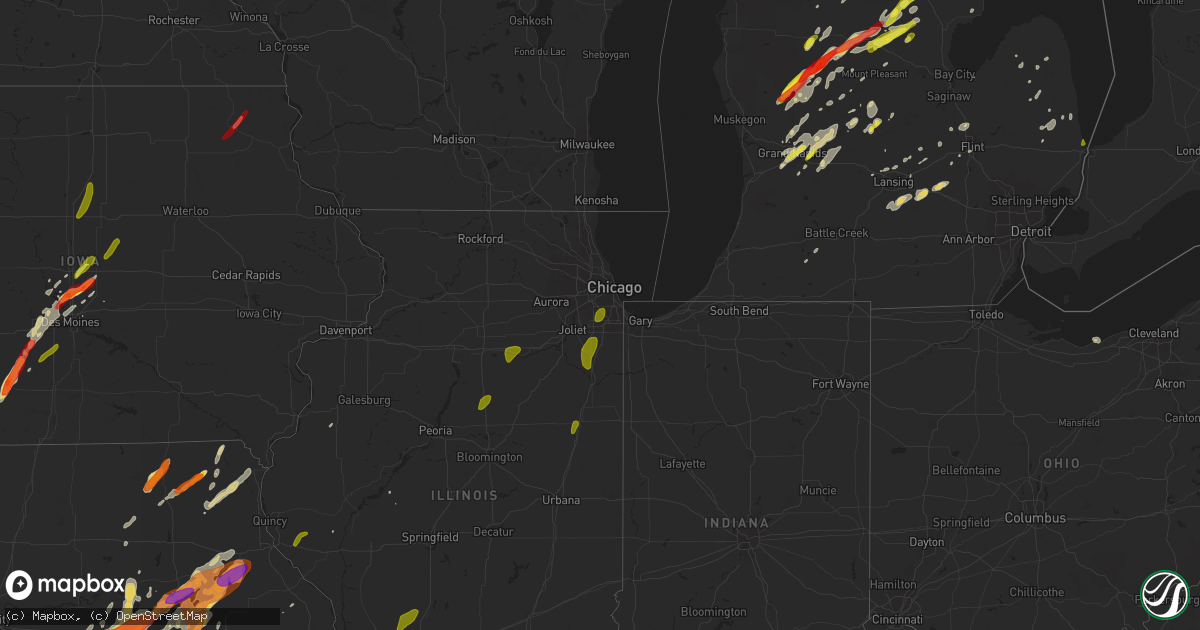
Hail Map on May 20, 2013
Get this storm
May 20 map
$229
one time, instant access
Download today. No call, no setup
Keep the $229
Bought the map and want the full workflow? Apply the entire $229 to a subscription within 7 days. None of it is wasted.
Every map, not just this one
This buys you this map. Subscription and you get every map we run, in the markets you choose from a few cities to whole states to nationwide. Plus real-time alerts the moment a storm fires.
Contact data
Name, contact info, occupancy, even credit band for addresses in the footprint. You go from where it hit to who to call.
Become the source they trust
Unlimited branding weather history reports on demand. You already have the documented answer ready for the property owner, and you are the one who showed up with it.
Property data and RoofTrace estimates
Pull up any address you have got, its value and the exact code rules for that jurisdiction, straight from One Click Code. Then RoofTrace estimates the squares, pitch, and roof value, priced the way you price.
States Impacted by Hail Map on May 20, 2013
Storm reports
Virginia
| Date | Description |
|---|---|
| 05/20/20134:48 PM CDT | Large tree limbs snapped from maple tree |
| 05/20/20134:48 PM CDT | Quarter-size hail |
Missouri
| Date | Description |
|---|---|
| 05/20/20136:57 PM CDT | Reports of damage to roof of city hall. |
| 05/20/20136:57 PM CDT | Time of event estimated. |
| 05/20/20136:57 PM CDT | Trees reported down. |
| 05/20/20136:56 PM CDT | An ef-0 tornado produced up to 80 mph winds and uprooted trees along a half mile long and 200 yard wide path. |
| 05/20/20136:55 PM CDT | Trees down and power outages in and around the vicinity of blue eye. |
| 05/20/20136:55 PM CDT | Tree fell onto house. |
| 05/20/20136:53 PM CDT | 2 large trees blown down in florida |
| 05/20/20136:53 PM CDT | Picture from social media. Time was estimated. |
| 05/20/20136:43 PM CDT | Trees and power lines reported down throughout the county. |
| 05/20/20136:43 PM CDT | Roof damage to trailer home. |
| 05/20/20136:40 PM CDT | One inch hail fell at the intersection of highways d and dd. |
| 05/20/20136:40 PM CDT | Nws storm survey confirmed a tornado was on the ground crossing into missouri from oklahoma and continued to about 0.5 miles southeast of seneca. Numerous trees were sn |
| 05/20/20136:37 PM CDT | An ef-0 tornado touched down about 3 miles south of stockton along east 1674 road. This tornado continued on a 2.1 mile long path through orleans trail public use area |
| 05/20/20136:35 PM CDT | Half dollar size hail on the northeast side of columbia |
| 05/20/20136:34 PM CDT | A local report indicates 2.00 inch wind near 2 S GERALD |
| 05/20/20136:34 PM CDT | A local report indicates 1.25 inch wind near 1 NE MURRY |
| 05/20/20136:34 PM CDT | Barn blown into trailer home and damaged trailer. |
| 05/20/20136:30 PM CDT | Dime to quarter |
| 05/20/20136:25 PM CDT | Hail 1.5 miles east of columbia on hwy 63 near hwy ww. |
| 05/20/20136:25 PM CDT | Hail caused damage to trees and minor damage to several vehicles. |
| 05/20/20136:23 PM CDT | 1 inch to 1.5 inch diameter hail. About 1 mile north of highway m and highway w. |
| 05/20/20136:21 PM CDT | Hail 1.5 miles east of columbia on hwy 63 near hwy ww. |
| 05/20/20136:20 PM CDT | Possible tornado. Damage to outbuildings along with trees and power lines down. Survey team to finish evaluation tomorrow. |
| 05/20/20136:18 PM CDT | A local report indicates 1.00 inch wind near MADISON |
| 05/20/20136:17 PM CDT | Hail lasted for 2 to 3 minutes and ended at 617 pm cdt |
| 05/20/20136:15 PM CDT | Roof damage to building at intersection of highway c and f approximately 3 miles northeast of lamar. |
| 05/20/20136:15 PM CDT | Several bldgs damaged. Roofs in lamar by estimated 75 mph winds. |
| 05/20/20136:15 PM CDT | A local report indicates 1.00 inch wind near 5 E MOBERLY |
| 05/20/20136:08 PM CDT | 1.0 inch hail reported by trained spotter |
| 05/20/20136:03 PM CDT | An ef-1 tornado touched down 7 miles west northwest of lamar...and tracked 6.78 miles to the northeast. Trees along with a couple of outbuildings were destroyed. Estima |
| 05/20/20135:52 PM CDT | Hail reported just north of belle near intersection of highway 89 and highway y |
| 05/20/20135:51 PM CDT | Relayed by county emergency management. |
| 05/20/20135:37 PM CDT | An ef-0 tornado touched down about 3 miles south of stockton along east 1674 road. This tornado continued on a 2.1 mile long path through orleans trail public use area |
| 05/20/20135:36 PM CDT | A local report indicates 1.50 inch wind near 2 N VIENNA |
| 05/20/20135:20 PM CDT | Time corrected...possible tornado. Damage to outbuildings along with trees and power lines down. Survey team to finish evaluation tomorrow. |
| 05/20/20135:06 PM CDT | A local report indicates 1.50 inch wind near IBERIA |
| 05/20/20134:35 PM CDT | Time estimated. |
| 05/20/20134:20 PM CDT | A local report indicates 1.75 inch wind near HOLDEN |
| 05/20/20134:20 PM CDT | A local report indicates 1.00 inch wind near ELDRIDGE |
| 05/20/20134:05 PM CDT | A local report indicates 1.00 inch wind near 3 NNW BENNETT SPRINGS |
| 05/20/20133:45 PM CDT | A local report indicates 1.00 inch wind near HARRISONVILLE |
| 05/20/20133:30 PM CDT | Quarter to half dollar size hail at hwy yy and hwy h |
| 05/20/20133:22 PM CDT | A local report indicates 1.00 inch wind near 6 N DREXEL |
| 05/20/20133:15 PM CDT | A local report indicates 1.75 inch wind near DREXEL |
| 05/20/20138:36 AM CDT | A local report indicates 1.75 inch wind near 7 E AMSTERDAM |
| 05/19/201311:26 PM CDT | 20-25 inch diameter tree down on power lines at the intersection of n mountain and w russel st |
| 05/19/201311:00 PM CDT | Power lines down along carolton street |
| 05/19/201310:55 PM CDT | Power lines and trees down at highway yy and highway 142 |
| 05/19/201310:52 PM CDT | Moderate tree damage |
| 05/19/201310:49 PM CDT | Power outages reported in park hills |
| 05/19/201310:47 PM CDT | Power outages across much of the city of bonne terre |
| 05/19/201310:40 PM CDT | Tree limbs and power lines down in bonne terre and park hills |
| 05/19/201310:39 PM CDT | 10-12 inch diameter tree across highway 49 north of viburnum. |
| 05/19/201310:12 PM CDT | A local report indicates 60 MPH wind near OLIVETTE |
| 05/19/201310:07 PM CDT | Trees and power lines reported down. |
| 05/19/20139:55 PM CDT | Multiple large trees snapped in the winchester area |
| 05/19/20139:47 PM CDT | A local report indicates 69 MPH wind near 4 NNE ORCHARD FARMS |
| 05/19/20139:15 PM CDT | Barn damaged and power lines down on highway z approximately one mile west of highway 5. |
| 05/19/20139:04 PM CDT | A local report indicates 1.25 inch wind near 2 N GROVESPRING |
| 05/19/20139:04 PM CDT | Multiple trees snapped. |
| 05/19/20139:00 PM CDT | Several homes had shingles blown off roof. Small sheds blown over. |
| 05/19/20138:49 PM CDT | Trees reported down. |
| 05/19/20138:46 PM CDT | Two trees reported down. |
| 05/19/20138:46 PM CDT | An ef-0 tornado briefly touched down about 3 miles west northwest of gravois mills uprooting numerous trees and causing minor structural damage. The tornado was 100 yar |
| 05/19/20138:37 PM CDT | A local report indicates 60 MPH wind near 3 SW FORDLAND |
| 05/19/20138:33 PM CDT | Power lines down at mexico and bryan road |
| 05/19/20138:31 PM CDT | Two mobil homes eported damaged from fallen trees. |
| 05/19/20138:29 PM CDT | Dime sized hail as well |
| 05/19/20138:24 PM CDT | A local report indicates 1.00 inch wind near ST. PETERS |
| 05/19/20138:20 PM CDT | Haybarn destroyed. Time of event estimated. |
| 05/19/20138:17 PM CDT | A local report indicates 1.00 inch wind near HARVESTER |
| 05/19/20138:17 PM CDT | A local report indicates 1.00 inch wind near ST. CHARLES |
| 05/19/20138:14 PM CDT | A few trees were down by high winds in californa mo. |
| 05/19/20138:12 PM CDT | 1 tree blown down |
| 05/19/20138:10 PM CDT | Power outages reported at highway f and 65 north of branson. |
| 05/19/20138:10 PM CDT | Wind damage to shingles and siding to a couple of hotels on west side of branson. |
| 05/19/20138:09 PM CDT | Nuimerous branches downed. Wind speed 55 mph. |
| 05/19/20138:09 PM CDT | Roof blown off mobil home into power lines near 438 highway and highway mm. |
| 05/19/20138:05 PM CDT | Numerous trees reported down in and near reeds spring. Trees also reported down along highway 413. |
| 05/19/20138:05 PM CDT | An ef-1 tornado 100 yards wide and 1.4 miles long uprooted trees along its path. Estimated wind speeds were around 90 mph. |
| 05/19/20138:05 PM CDT | An ef-0 tornado 100 yards wide and 0.6 miles long caused some tree damage along its path. Estimated wind speeds were 80 to 85 mph. |
| 05/19/20138:04 PM CDT | A local report indicates 1.25 inch wind near 2 N GROVESPRING |
| 05/19/20138:04 PM CDT | Multiple trees snapped. |
| 05/19/20138:04 PM CDT | Damage to siding and shingles to a couple hotels near white water park. |
| 05/19/20138:00 PM CDT | Tree and powerlines down at green hills drive and tower road. |
| 05/19/20137:59 PM CDT | A local report indicates 60 MPH wind near BRANSON WEST |
| 05/19/20137:55 PM CDT | Shed collapsed |
| 05/19/20137:50 PM CDT | Delayed report of a tree down near campbell road and nottingham road. |
| 05/19/20137:50 PM CDT | An ef-1 tornado uprooted and damaged trees along its 1.4 mile long path with maximum winds of 110 mph and path width of 200 yards. |
| 05/19/20137:46 PM CDT | An ef-0 tornado briefly touched down about 3 miles west northwest of gravois mills uprooting numerous trees and causing minor structural damage. The tornado was 100 yar |
| 05/19/20137:45 PM CDT | Damage to roof and deck. Trees down. |
| 05/19/20137:40 PM CDT | A local report indicates 60 MPH wind near GRAVOIS MILLS |
| 05/19/20137:36 PM CDT | There are several large trees snapped. - severe danage to two machine sheds near highway mm. Shingles removed at some buildings in downtown area. |
| 05/19/20137:35 PM CDT | A local report indicates 58 MPH wind near HANNIBAL |
| 05/19/20137:32 PM CDT | A small hole in the roof at the hannibal - lagrange science building was uncovered and not the entire roof. |
| 05/19/20137:30 PM CDT | Numerous trees uprooted |
| 05/19/20137:29 PM CDT | Large limbs blown down |
| 05/19/20137:29 PM CDT | A local report indicates a tornado near HANNIBAL |
| 05/19/20137:25 PM CDT | Trees uprooted one quarter mile southeast of airport |
| 05/19/20137:24 PM CDT | Trained spotter reported 1.00 inch hail in union missouri |
| 05/19/20137:20 PM CDT | Possible tornado. Damage to outbuildings along with trees and power lines down. Survey team to finish evaluation tomorrow. |
| 05/19/20137:20 PM CDT | Picture from social media showed a large tree blown down near warsaw. Time was estimated by radar. |
| 05/19/20137:15 PM CDT | Picture from social media of a tree snap and fell on an out building. Time was estimated. |
| 05/19/20137:05 PM CDT | Several large trees blown down and minor structural damage to roof to city hall. Large tree fell on a house. Windows blown out to area cafe. |
| 05/19/20137:02 PM CDT | Emergency manager reports hundreds of trees down throughout the eastern portion of st. Clair county due to straight line winds. |
Kentucky
| Date | Description |
|---|---|
| 05/20/20135:05 AM CDT | Power loss and downed trees on us hwy 421. |
| 05/20/20133:00 AM CDT | Trees down. |
| 05/20/20133:00 AM CDT | 2 large trees down in lovelaceville near highway 62. Utility companies working to clear damage. |
Arkansas
| Date | Description |
|---|---|
| 05/20/20136:49 PM CDT | Photo of a small tornado received. Tree damage was reported in the area. Time estimated via radar. |
| 05/20/20135:20 AM CDT | A tree was blown down. |
| 05/20/20135:00 AM CDT | Limbs were blown down. |
| 05/20/20134:12 AM CDT | Limbs were blown down. |
| 05/20/20133:14 AM CDT | Trees and power lines were blown down. A tree was on a house...and a roof was peeled off a storage shed. |
| 05/20/20133:13 AM CDT | Several power poles down just south of heber springs. |
| 05/20/20131:30 AM CDT | A local report indicates 60 MPH wind near JONESBORO |
| 05/20/20131:18 AM CDT | Tree limbs also down. |
| 05/20/201312:48 AM CDT | A local report indicates 58 MPH wind near NEWPORT AIR INDSTRL PK |
| 05/20/201312:35 AM CDT | A local report indicates 65 MPH wind near OIL TROUGH |
| 05/20/201312:12 AM CDT | Trees down...barn damaged...and both a camper and a mobile home were blown over on dripping springs road 2 miles southeast of steprock. |
| 05/20/201312:10 AM CDT | Trees were blown down. |
| 05/19/201311:55 PM CDT | Trees have been blown over as well as several tree limbs. |
| 05/19/201310:40 PM CDT | Trees down on highway 88 at sims. |
| 05/19/201310:17 PM CDT | Trees down in mill creek area of london. |
| 05/19/201310:10 PM CDT | A local report indicates 1.00 inch wind near HARMONY |
| 05/19/201310:00 PM CDT | A local report indicates 1.00 inch wind near COAL HILL |
| 05/19/20139:56 PM CDT | Nickel to quarter size hail |
| 05/19/20139:49 PM CDT | Debris blocking the intersection of highways 96 and 23. |
| 05/19/20139:49 PM CDT | Trees and power lines downed. |
| 05/19/20139:48 PM CDT | Trees down |
| 05/19/20139:44 PM CDT | Oak bend road blocked by downed trees near intersection with highway 96. |
| 05/19/20139:35 PM CDT | Small trees and branches down on highway 23 near the franklin/logan county line. |
| 05/19/20139:17 PM CDT | 3 to 4 foot tree snapped at its base. |
| 05/19/20139:15 PM CDT | Structure had windows blown out on washington street...several power outages reported...multiple trees down across county |
| 05/19/20138:37 PM CDT | Large tree down on the side of the road. |
| 05/19/20138:00 PM CDT | Tree down |
| 05/19/20137:40 PM CDT | Spotter reported several six inch diameter trees either blown over or snapped off at 10 ft level. Wind estimate of 65 to 75 mph. |
| 05/19/20137:40 PM CDT | A local report indicates 80 MPH wind near EUREKA SPRINGS |
| 05/19/20137:37 PM CDT | Several large trees and power poles down...numerous limb damage |
| 05/19/20137:29 PM CDT | Several large trees down...one tree fell through roof |
| 05/19/20137:25 PM CDT | Tree down on a house. |
| 05/19/20137:21 PM CDT | Tree down on a house. |
| 05/19/20137:21 PM CDT | Nws survey indicated an ef-1 tornado occurred in the rocky branch area. Several mobile homes were significantly damaged including numerous trees downed. Time estimated |
| 05/19/20137:21 PM CDT | Aslo reported pea size hail |
| 05/19/20137:17 PM CDT | A local report indicates 70 MPH wind near SPRINGDALE |
| 05/19/20137:16 PM CDT | Widespread wind damage across town. Numerous large trees downed and damaged. Power lines and power poles damaged. |
| 05/19/20137:15 PM CDT | Measured 69 mph wind gust near the springdale airport. |
| 05/19/20137:15 PM CDT | Measured 61 mph gust at the bentonville municipal airport |
| 05/19/20137:13 PM CDT | *** 1 fatal *** debris struck vehicle. |
| 05/19/20137:12 PM CDT | A local report indicates 65 MPH wind near BENTONVILLE |
| 05/19/20137:06 PM CDT | One structure was destroyed |
South Carolina
| Date | Description |
|---|---|
| 05/20/20134:50 PM CDT | Lasted for 15-20 minutes |
| 05/20/20134:26 PM CDT | South carolina highway patrol reported 2 trees down on indian field circle. Time estimated by radar. |
Colorado
| Date | Description |
|---|---|
| 05/20/20135:53 PM CDT | Brief landspout lasted for about 5-6 minutes in open field. |
Kansas
| Date | Description |
|---|---|
| 05/20/20135:53 PM CDT | Trees down. |
| 05/20/20135:50 PM CDT | Numersous scattered trees down and power lines down near pittsburg. A home sustained roof damage on the east side of pittsburg near 16th street and king highway. |
| 05/20/20135:10 PM CDT | Landspout tornado reported near the state line. |
| 05/20/20135:05 PM CDT | A landspout tornado was reported. Another previous landspout that occurred around 450pm had dissipated. |
| 05/20/20135:05 PM CDT | A possible landspout tornado was reported. Another previous landspout that occurred around 450pm had dissipated. |
| 05/20/20134:47 PM CDT | A local report indicates 1.50 inch wind near COFFEYVILLE |
| 05/20/20134:12 PM CDT | Brief touchdown along highway 166 near county road 3500. |
| 05/20/20133:21 PM CDT | A local report indicates 1.50 inch wind near 1 S HALE |
| 05/20/20133:05 PM CDT | A local report indicates 1.00 inch wind near 3 WNW DREXEL |
| 05/20/20133:02 PM CDT | A local report indicates 1.00 inch wind near 6 SE IOLA |
Florida
| Date | Description |
|---|---|
| 05/20/20135:55 PM CDT | Bradley county emergency management relayed report via social media that a tree and powerlines were blocking state route 100 at se 81st street in theressa. Time is esti |
| 05/20/20135:40 PM CDT | Tree down on parkview rd. Large flagpole down on the corner of polk ave and magnolia st |
| 05/20/20135:40 PM CDT | Tree down on se pointer avenue just south of arcadia municipal airport. |
| 05/20/20135:40 PM CDT | Tree down on sw baldiwn st. Time estimated by radar. |
| 05/20/20134:51 PM CDT | Reports of power lines and power poles down west of fort meade. Time estimated by radar. |
| 05/20/20134:30 PM CDT | Large trees down at sw 137 ave and sw williston rd. |
| 05/20/20134:25 PM CDT | Reports of power lines and power poles down west of fort meade. Time estimated by radar. |
| 05/20/20134:25 PM CDT | Numerous reports of quarter size hail and one report with golf ball size hail. Picture on social media. |
| 05/20/20133:50 PM CDT | Numerous large trees and powerlines down across the area. Time estimated based on radar. |
| 05/20/20133:25 PM CDT | Large tree down on a house in seffner. No injuries reported. Time estimated by radar. |
| 05/20/20133:05 PM CDT | *** 1 fatal *** a tree fell on two cars killing a man in one of the cars in the ocala area. The time given was based on radar. |
| 05/20/20133:00 PM CDT | The sheriffs office received reports of numerous trees down in the ocala area. The time given was based on radar. |
| 05/20/20133:00 PM CDT | Tree fell on a house. Time estimated by radar. |
| 05/20/20132:55 PM CDT | Broadcast media twitter page reports quarter size hail. Time estimated by radar |
North Carolina
| Date | Description |
|---|---|
| 05/20/20135:35 PM CDT | A local report indicates 1.25 inch wind near 7 ENE FRANKLIN |
| 05/20/20133:32 PM CDT | A local report indicates 1.00 inch wind near 2 S LAKE TOXAWAY |
| 05/20/20133:00 PM CDT | A local report indicates 1.00 inch wind near BALSAM GROVE |
Georgia
| Date | Description |
|---|---|
| 05/20/20136:30 PM CDT | Numerous tree limbs down up to 3 inches in diameter. Time estimated by radar. |
| 05/20/20134:48 PM CDT | A local report indicates 1.00 inch wind near 2 NW CLAYTON |
Illinois
| Date | Description |
|---|---|
| 05/20/20133:20 AM CDT | A large tree blew down landing on a car in metropolis. |
| 05/20/20133:00 AM CDT | Half of the roof of alexander county courthouse blown off. No other damage nearby. |
| 05/20/201312:25 AM CDT | Late report...quarter size hail reported. |
| 05/20/201312:01 AM CDT | Large walnut tree blown down. |
| 05/19/201311:40 PM CDT | Damage to several trees...power lines and power poles in various locations throughout the city. |
| 05/19/201311:25 PM CDT | 14 inch diameter tree snapped off. Grain bins destroyed and rolled over a car. Machine shed roof ripped off. 4 power poles snapped. Time estimated. |
| 05/19/201311:25 PM CDT | Farm equipment and truck blown over along with trees and powerlines blown down from high winds near sullivan. |
| 05/19/201311:22 PM CDT | Roof torn off a house and siding/shingle damage to another house. Damage to several trees. Wind estimated around 80-85 mph. Reported by coles county ema coordinator. |
| 05/19/201311:10 PM CDT | Facebook report. |
| 05/19/201310:32 PM CDT | Several trees and powerlines down...including some fairly large trees. |
| 05/19/201310:25 PM CDT | Trees uprooted |
| 05/19/201310:20 PM CDT | 3 buldings completely destroyed including the fire station on north street between cherry and blano streets |
| 05/19/201310:15 PM CDT | A local report indicates 60 MPH wind near EDWARDSVILLE |
| 05/19/201310:14 PM CDT | 2 foot diameter tree snapped at base |
| 05/19/201310:10 PM CDT | Roof blown off of bills iga grocery store...roof blown approx 30 to 40 feet away from building. Time estimated from radar. |
| 05/19/201310:08 PM CDT | A local report indicates 1.00 inch wind near BUNKER HILL |
| 05/19/20139:55 PM CDT | Reports of trees blown over and blocking roadways in princeton. |
| 05/19/20139:55 PM CDT | A local report indicates 58 MPH wind near 5 S SHIPMAN |
| 05/19/20139:54 PM CDT | Numerous trees and power lines down. Several roads blocked. Time estimated. |
| 05/19/20139:45 PM CDT | Emergency manager has surveyed a path of straight line wind damage from the north side of wyoming...to bradford. Damage included downed trees and tree limbs...power lin |
| 05/19/20139:40 PM CDT | Grain bin blown down |
| 05/19/20139:35 PM CDT | Shed blown over |
| 05/19/20139:35 PM CDT | 6 inch diameter tree branch snapped off by winds |
| 05/19/20139:25 PM CDT | Top half of large tree blown down on powerlines. |
| 05/19/20139:25 PM CDT | Large tree limb down on power lines and damage to garage door. |
| 05/19/20139:25 PM CDT | Two large trees and powerlines down across route 78. |
| 05/19/20139:25 PM CDT | Large tree blown down across route 8 at texas road. |
| 05/19/20139:22 PM CDT | Two large trees blown down. |
| 05/19/20139:20 PM CDT | Large tree limbs down on powerlines at route 78 and schissler road. |
| 05/19/20139:15 PM CDT | Grain bin blown down |
| 05/19/20139:11 PM CDT | Near interstate 80. Frequent strong wind gusts. |
| 05/19/20139:10 PM CDT | Large trees uprooted and power lines down. Time estimated. |
| 05/19/20139:05 PM CDT | A 12-inch diameter tree was blown down. |
| 05/19/20138:54 PM CDT | Numerous trees and power lines down. Several roads blocked. Time estimated. Corrected time. |
| 05/19/20138:45 PM CDT | Emergency manager has surveyed a path of straight line wind damage from the north side of wyoming...to bradford. Damage included downed trees and tree limbs...power lin |
| 05/19/20138:43 PM CDT | A local report indicates 58 MPH wind near 8 E PETERSBURG |
| 05/19/20138:40 PM CDT | Power pole knocked down |
| 05/19/20138:38 PM CDT | Power pole knocked down |
| 05/19/20138:38 PM CDT | Several tree branches down |
| 05/19/20138:35 PM CDT | Trees and power lines down. Time estimated. |
| 05/19/20138:35 PM CDT | Power lines blown down |
| 05/19/20137:50 PM CDT | 8 inch diameter tree limb snapped off and landed on a roof. |
| 05/19/20137:45 PM CDT | One inch hail reported in liberty illinois. |
| 05/19/20137:45 PM CDT | A few small trees blown over in town |
| 05/19/20137:39 PM CDT | Tree fell on fence |
| 05/19/20137:35 PM CDT | Amateur radio operator repoted estimated 60 to 65 mph. |
| 05/19/20137:35 PM CDT | A local report indicates 60 MPH wind near HULL |
| 05/19/20137:33 PM CDT | Damage to a garage...power poles snapped and several large trees uprooted in payson il. |
Michigan
| Date | Description |
|---|---|
| 05/20/20136:17 PM CDT | Wires and powerlines downed |
| 05/20/20136:12 PM CDT | Downed power lines. Radar estimated time. |
| 05/20/20136:03 PM CDT | Power lines down |
| 05/20/20136:01 PM CDT | Tree down across the road at rich road and murphy lake road |
| 05/20/20136:00 PM CDT | Trees downed at fenton and lakeside landing roads |
| 05/20/20135:55 PM CDT | 12 inch diameter trees downed at sharp and grand blanc roads |
| 05/20/20135:54 PM CDT | 8 inch diameter tree limb down. |
| 05/20/20135:52 PM CDT | Branches on power lines north of town. Tree debris was seen all along u.s. 127 from dewitt to st. Johns. |
| 05/20/20135:46 PM CDT | Trees down at fischer and faussett roads |
| 05/20/20135:42 PM CDT | Large tree limbs downed |
| 05/20/20135:38 PM CDT | 15 inch tree limbs downed at pasadena and i-75 |
| 05/20/20135:33 PM CDT | Trees down at owosso and hayner roads |
| 05/20/20135:20 PM CDT | Ingham co dispatch stated that trees and power lines were reported down |
| 05/20/20135:12 PM CDT | Trees and power lines down. Radar estimated time. |
| 05/20/20135:07 PM CDT | Downed power lines. Radar estimated time. |
| 05/20/20135:03 PM CDT | Downed power line. Radar estimated time. |
| 05/20/20134:59 PM CDT | Trees down. |
| 05/20/20134:56 PM CDT | Power lines and trees down. Radar estimated time. |
| 05/20/20134:53 PM CDT | Snapped powerline in northern tuscola county |
| 05/20/20134:52 PM CDT | Barn blown down. Radar estimated time. |
| 05/20/20134:50 PM CDT | Power lines down. |
| 05/20/20134:30 PM CDT | Metal panel roof blown off of a car wash near the intersection of warwick drive and wright ave. |
| 05/20/20134:30 PM CDT | Clinton co dispatch and em reported power lines and several tree limbs were down in the southwest portion of the county.tree limbs were 10 to 12 inches in diameter. |
| 05/20/20134:25 PM CDT | Ham radio operator reported pea size hail along with measured thunderstorm wind gusts |
| 05/20/20134:15 PM CDT | Numerous power lines down. |
| 05/20/20134:10 PM CDT | Power poles down just east of alma on lincoln road. One person is trapped in their vehicle due to down lines. Verified by alma police dept |
| 05/20/20134:10 PM CDT | Numerous trees and wires down. |
| 05/20/20134:10 PM CDT | Utility trailers blown onto their sides along m-46.several power poles broken. Spotter also noted large tree limbs down |
| 05/20/20134:07 PM CDT | Trees down. |
| 05/20/20134:05 PM CDT | Trees down |
| 05/20/20133:57 PM CDT | Roof reported blown off a house |
| 05/20/20133:56 PM CDT | Power lines and trees down. Radar estimated time. |
| 05/20/20133:53 PM CDT | Trees down |
| 05/20/20133:50 PM CDT | Spotter reported large trees and power lines down. Trees were one to one and a half foot in diameter. |
| 05/20/20133:30 PM CDT | A local report indicates 1.00 inch wind near 4 E BEAVERTON |
| 05/20/20133:30 PM CDT | 14 inch diameter trees down around albright shores |
| 05/20/20133:30 PM CDT | Semi trailer blown over |
| 05/20/20133:20 PM CDT | Numerous trees down. |
| 05/20/20133:20 PM CDT | Spotter reported several 5-6 inch tree limbs down |
| 05/20/20133:15 PM CDT | Ionia co central dispatch stated that they had various reports of trees and limbs down in the belding and orleans areas |
| 05/20/20132:37 PM CDT | Power poles snapped in half in a field |
| 05/20/20132:36 PM CDT | Mecosta co. Dispatch stated a downed tree has brought down two power lines near 8 mile road and us 131 |
| 05/20/20132:20 PM CDT | A local report indicates 1.00 inch wind near 1 NE GRAND RAPIDS |
| 05/20/20132:20 PM CDT | Information relayed from the public via wood tv |
| 05/20/20132:16 PM CDT | Ping pong ball sized hail |
| 05/20/20132:15 PM CDT | A local report indicates 1.00 inch wind near HARRISON |
| 05/20/20132:10 PM CDT | Reported at walloon lake country club. 40 trees uprooted. Wind speed estimated at 70 mph. |
| 05/20/20132:10 PM CDT | Trees down. |
| 05/20/20132:10 PM CDT | Power lines down. |
| 05/20/20132:00 PM CDT | Tree down in mancelona. |
| 05/20/20131:55 PM CDT | A local report indicates 1.00 inch wind near 3 ESE BELLAIRE |
| 05/20/20131:51 PM CDT | A local report indicates 1.75 inch wind near 4 SE KALKASKA |
| 05/20/20131:45 PM CDT | At hardy dam. |
| 05/20/20131:28 PM CDT | Relayed by wzzm13. Measured one and six tenths diameter hail. |
| 05/20/20131:23 PM CDT | Tree down in kewadin. |
| 05/20/20131:23 PM CDT | Multiple trees down |
| 05/20/20131:08 PM CDT | A local report indicates 1.00 inch wind near 3 S NORTHPORT |
| 05/20/201312:51 PM CDT | A local report indicates 1.00 inch wind near 3 W TRAVERSE CITY |
| 05/19/20137:35 PM CDT | Slightly larger than quarters. |
Indiana
| Date | Description |
|---|---|
| 05/20/20133:02 AM CDT | Couple trees down in southwest decatur county. |
| 05/20/20133:02 AM CDT | Trees down. At least one down on a vehicle |
| 05/20/20132:54 AM CDT | Tree damage at 950 w and 700 s. |
| 05/20/20132:45 AM CDT | Tree down on state road 32 near windsor way. |
| 05/20/20132:45 AM CDT | Two foot diameter tree blown onto vehicle. Time estimated. |
| 05/20/20132:30 AM CDT | Tree down at intersection of 100n and 200e. Winds estimated around 65 mph. |
| 05/20/20132:30 AM CDT | A local report indicates 62 MPH wind near FISHERS |
| 05/20/20132:30 AM CDT | 3 inch diamater tree snapped at 116th and spingmill road. Time estimated. Report via twiiter. |
| 05/20/20132:20 AM CDT | Trees down as well as damage to a cvs and speedway gas station. |
| 05/20/20132:20 AM CDT | Trees and limbs down near intersection of shelbyville and franklin road |
| 05/20/20132:20 AM CDT | Trees and limbs down |
| 05/20/20132:10 AM CDT | Multiple trees and power lines down |
| 05/20/20132:05 AM CDT | Trees downed. |
| 05/20/20132:05 AM CDT | Trees and limbs down |
| 05/20/20132:02 AM CDT | Tree and power line damage. No reports of power outages. Reports from southern part of county. |
| 05/20/20132:00 AM CDT | Power lines down near echo lake. |
| 05/20/20132:00 AM CDT | Trees and power lines down |
| 05/20/20132:00 AM CDT | Barn destroyed. Trees down. Irrigation system flipped. Time estimated. Corrected direction from earlier report of roachdale 3s |
| 05/20/20132:00 AM CDT | Extensive damage near soccer field at school just off of bridge road. Reported by bob pruitt. |
| 05/20/20132:00 AM CDT | Barn destroyed. Trees down. Irrigation system flipped. Time estimated. |
| 05/20/20132:00 AM CDT | Two chicken houses destroyed. |
| 05/20/20132:00 AM CDT | Trees downed near cartersburg |
| 05/20/20132:00 AM CDT | Trees down in hazelwood. |
| 05/20/20131:47 AM CDT | Minor tree damage in the county. |
| 05/20/20131:45 AM CDT | Large tree down on burnett rd. |
| 05/20/20131:42 AM CDT | Tree damage reported. |
| 05/20/20131:42 AM CDT | Tree damage reported. |
| 05/20/20131:40 AM CDT | Ef0 tornado caused damage tree and roof damage. Updating previous damaging thunderstorm wind report. Time estimated from radar. |
| 05/20/20131:38 AM CDT | Several trees knocked over in downtown washington. Main street was closed for a few hours until trees were removed. |
| 05/20/20131:30 AM CDT | Ef0 tornado. Trees down. Barn destroyed. Irrigation system flipped. This is an update to the earlier report of damaging thunderstorm winds at 3e roachdale. |
| 05/20/20131:24 AM CDT | Trees down and some roof structure damage. Power outages. Also reported dime size hail. |
| 05/20/20131:20 AM CDT | Minor tree damage in the county. |
| 05/20/20131:15 AM CDT | Trees downed |
| 05/20/20131:15 AM CDT | Multiple trees down in the area |
| 05/20/20131:05 AM CDT | Barn destroyed. Trees downed. |
| 05/20/201312:00 AM CDT | Tree down. Facebook report. Time estimated from radar. |
Iowa
| Date | Description |
|---|---|
| 05/20/20136:45 PM CDT | Pea to golf ball hail 5 miles ne creston |
| 05/20/20136:41 PM CDT | Golf ball hail covering the ground. Hail lasted 12 minutes |
| 05/20/20136:40 PM CDT | Golf ball reported ne side of creston |
| 05/19/20139:23 PM CDT | Measured at rwis station on hw 30. |
| 05/19/20138:50 PM CDT | Mitchellville fd reported several trees down in town...8 to 10 inch diameter branches snapped. |
| 05/19/20138:33 PM CDT | Winds of 50 to 60 mph also estimated. |
| 05/19/20138:30 PM CDT | A local report indicates 1.00 inch wind near 3 N OSSIAN |
| 05/19/20138:22 PM CDT | Utility lines bent to the east. Time estimated from radar. |
| 05/19/20138:15 PM CDT | Pea size hail as well. |
| 05/19/20138:11 PM CDT | Tree fell and took out powerlines near bangor. |
| 05/19/20138:10 PM CDT | Pea to dime size hail. |
| 05/19/20137:40 PM CDT | Quarter size hail started at 738 pm. |
| 05/19/20137:33 PM CDT | Nickel to quarter size hail at intersection of 620th ave and 340th st. |
| 05/19/20137:24 PM CDT | Mainly pea size hail with stones up to quarter size. |
| 05/19/20137:19 PM CDT | A local report indicates 1.75 inch wind near 5 NW ANKENY AIRPORT |
| 05/19/20137:16 PM CDT | A local report indicates 1.00 inch wind near 4 NNW ANKENY AIRPORT |
| 05/19/20137:10 PM CDT | Report of tree limbs down in eastern lee county. Time estimated by radar. |
Tennessee
| Date | Description |
|---|---|
| 05/20/20132:30 AM CDT | One half of roof off of barn...tree down...and siding/shingles missing off of a couple of homes. |
New York
| Date | Description |
|---|---|
| 05/20/20131:20 AM CDT | Trees down. |
| 05/20/20131:20 AM CDT | Trees down. |
| 05/20/201312:50 AM CDT | Power pole down |
| 05/20/201312:30 AM CDT | Wires down and quarter sized hail |
| 05/20/201312:30 AM CDT | Wires down and quarter sized hail |
| 05/20/201312:15 AM CDT | Large tree down on car... Other large limbs down in area |
Texas
| Date | Description |
|---|---|
| 05/20/20136:30 PM CDT | A local report indicates 1.00 inch wind near HENRIETTA |
| 05/20/20136:29 PM CDT | Quarter sized hail reported 3 miles west of capps corner |
| 05/20/20136:28 PM CDT | Power polls down...trees sheared off...high school roof damamged...and damage to the bus barn. |
| 05/20/20136:15 PM CDT | Cert member reports the doors at the walmart were ripped off the hinges by thunderstorm winds |
| 05/20/20136:00 PM CDT | Tornado reported at rr-1467 and co-291 by amateur radio operator. |
| 05/20/20135:58 PM CDT | A local report indicates 1.50 inch wind near NOCONA |
| 05/20/20135:45 PM CDT | Dps reported a tornado on the ground in the community of blanket. |
| 05/20/20135:41 PM CDT | Brief tornado reported 1 mile south of ringgold. |
| 05/20/20135:36 PM CDT | Several reports of golfball sized hail across the county. |
| 05/20/20134:53 PM CDT | 5 miles west of fisher rd |
| 05/20/20134:40 PM CDT | A local report indicates 1.75 inch wind near WICHITA FALLS |
| 05/20/20134:39 PM CDT | Tornado reported by ham radio operator |
| 05/20/20134:39 PM CDT | Tornado reported by ham radio operator |
| 05/20/20133:57 PM CDT | Quarter size hail just north of lake brownwood. |
| 05/20/20133:48 PM CDT | Intersection of fm 2526 and hwy 6 north of romney |
| 05/20/20133:40 PM CDT | Golf ball size hail reported on hwy 279 near country road 115 at lake brownwood. |
| 05/20/20132:20 PM CDT | A local report indicates 1.75 inch wind near SHEPPARD AFB |
| 05/20/20132:15 PM CDT | A local report indicates 1.25 inch wind near 1 W SHEPPARD AFB |
| 05/19/201311:23 PM CDT | Nickel to quarter sized hail reported 12 miles east of evant. |
| 05/19/201311:18 PM CDT | Golfball sized hail reported 9 miles east of evant |
| 05/19/20139:42 PM CDT | Golfball sized hail reported in and west of priddy. |
| 05/19/20139:21 PM CDT | A local report indicates 1.00 inch wind near 2 S HAMILTON |
| 05/19/20139:10 PM CDT | A local report indicates 1.75 inch wind near POTTSVILLE |
| 05/19/20139:10 PM CDT | Trained spotters reported quarter size hail in blanket. |
| 05/19/20138:47 PM CDT | A local report indicates 1.00 inch wind near HAMILTON |
| 05/19/20138:40 PM CDT | A local report indicates 1.50 inch wind near HAMILTON |
| 05/19/20138:07 PM CDT | Storm spotters reported quarter size hail in blanket. |
| 05/19/20137:25 PM CDT | S.o. Reports a tornado near priddy uprooted trees. |
| 05/19/20137:25 PM CDT | A barn was blown over fm-218 east of priddy. Probably associated with a tornado. |
| 05/19/20137:20 PM CDT | Amateur radio operator reported golf ball size hail northeast of zephyr. |
| 05/19/20137:10 PM CDT | Public reported via facebook...golf ball size hail 2 miles east of zephyr. |
Oklahoma
| Date | Description |
|---|---|
| 05/20/20136:39 PM CDT | Spotter reported tree branches down in area |
| 05/20/20136:36 PM CDT | Tornado reported by trained spotter and colocated with a strong radar circulation. Trees down on highway 62. Tornado may have continued to near the illinois river bridg |
| 05/20/20136:30 PM CDT | West facing garage doors and fence bowed in. About 10 bradford pear trees damaged with some completely snapped. Branches on large trees snapped. Heavy metal patio furni |
| 05/20/20136:30 PM CDT | Damage to a diesel shop. Numerous power poles snapped. Semi trailers blown off the road. 50 to 60 foot tree also blocking a roadway 3 miles east of twin bridges likely |
| 05/20/20136:00 PM CDT | Measured 66 mph wind gust at the vinita mesonet. |
| 05/20/20135:52 PM CDT | A local report indicates 1.00 inch wind near WAINWRIGHT |
| 05/20/20135:49 PM CDT | 60 to 65 mph winds reported by the checotah police department. |
| 05/20/20135:45 PM CDT | Em reports roof blown off of old gene autry gym. |
| 05/20/20135:43 PM CDT | A local report indicates 1.00 inch wind near 2 SSE TURNER FALLS |
| 05/20/20134:59 PM CDT | Large tree limbs downed |
| 05/20/20134:52 PM CDT | A local report indicates 1.75 inch wind near 6 W STRATFORD |
| 05/20/20134:50 PM CDT | A local report indicates 2.75 inch wind near AVANT |
| 05/20/20134:45 PM CDT | A local report indicates 2.50 inch wind near CORNISH |
| 05/20/20134:36 PM CDT | A local report indicates 1.75 inch wind near WHITEBEAD |
| 05/20/20134:35 PM CDT | Reported by oklahoma highway patrol |
| 05/20/20134:30 PM CDT | Reported by kwtv |
| 05/20/20134:15 PM CDT | A local report indicates 1.00 inch wind near WAURIKA |
| 05/20/20134:12 PM CDT | A local report indicates 2.00 inch wind near WILL ROGERS AIRPORT |
| 05/20/20133:56 PM CDT | Multiple spotters and broadcast media report a large tornado on the ground that first developed near avant and continued northeastward into washington county. A tornado |
| 05/20/20133:15 PM CDT | Softball and baseball hail observed 8n of herd |
| 05/20/20133:06 PM CDT | A local report indicates 2.50 inch wind near 3 NNW MOORE |
| 05/20/20132:28 PM CDT | A local report indicates 1.00 inch wind near WILL ROGERS AIRPORT |
| 05/20/20132:27 PM CDT | A local report indicates 3.25 inch wind near YUKON |
| 05/20/20132:02 PM CDT | A local report indicates 1.00 inch wind near 6 W DUNCAN |
| 05/20/20131:56 PM CDT | A local report indicates 1.00 inch wind near 1 S RUSH SPRINGS |
| 05/20/20131:54 PM CDT | A local report indicates 1.75 inch wind near 6 N MARLOW |
| 05/20/201312:30 PM CDT | A local report indicates 1.25 inch wind near ADA |
| 05/20/20135:50 AM CDT | A local report indicates 60 MPH wind near 2 NNW NINNEKAH |
| 05/20/20135:49 AM CDT | Trees and power lines down |
| 05/20/20135:46 AM CDT | A local report indicates 1.75 inch wind near NINNEKAH |
| 05/20/20135:26 AM CDT | Roof off of building by highway 277...blocking roadway. |
| 05/20/20135:25 AM CDT | A local report indicates 1.00 inch wind near CYRIL |
| 05/20/20135:20 AM CDT | Tree damage and powerlines down. |
| 05/20/20135:17 AM CDT | A local report indicates 77 MPH wind near 2 W CYRIL |
| 05/20/20134:00 AM CDT | A local report indicates 1.00 inch wind near 1 E PURCELL |
| 05/20/201312:30 AM CDT | A local report indicates 1.25 inch wind near ADA |
| 05/20/201312:26 AM CDT | A local report indicates 1.00 inch wind near ADA |
| 05/19/201311:34 PM CDT | From kswo |
| 05/19/201311:27 PM CDT | Public reported hail covering ground...dimes to quarters. |
| 05/19/201311:26 PM CDT | At stephens county fairgrounds |
| 05/19/201310:25 PM CDT | A local report indicates 1.25 inch wind near 2 SW GERONIMO |
| 05/19/201310:25 PM CDT | A local report indicates 1.75 inch wind near GERONIMO |
| 05/19/20139:58 PM CDT | At intersection of sh-22 and albert pike road |
| 05/19/20139:09 PM CDT | A local report indicates 2.75 inch wind near 4 S LITTLE CITY |
| 05/19/20139:08 PM CDT | 12 inch tree limbs downed. |
| 05/19/20139:00 PM CDT | Tree damage at clayton lake state park. |
| 05/19/20138:50 PM CDT | Law enforcement radio reported a tornado near cameron colocated with a strong radar circulation. It may have continued to the rock island vicinity. Emergency management |
| 05/19/20138:46 PM CDT | Nws survey indicated a ef-0 occurred between poteau and cameron. Time estimated by radar. Additional information to be determined. |
| 05/19/20138:41 PM CDT | Tree down along highway 101. |
| 05/19/20138:41 PM CDT | Building downtown with its roof blown off. Numerous buildings have windows blown out. Numerous trees and power lines down. |
| 05/19/20138:41 PM CDT | Sustained 55 to 60 mph winds |
| 05/19/20138:32 PM CDT | Report from law enforcement radio of a tornado between mccurtain and bokoshe colocated with a strong radar circulation. Broadcast media reported power flashes in the ar |
| 05/19/20138:24 PM CDT | A local report indicates 1.00 inch wind near MARIETTA |
| 05/19/20138:14 PM CDT | Trees and powerlines down in town. |
| 05/19/20138:05 PM CDT | A local report indicates 62 MPH wind near 7 WNW ARDMORE |
| 05/19/20138:00 PM CDT | Emergency management reports trees down and power line down in western durant. |
| 05/19/20137:55 PM CDT | Measured wind gust of 66 mph at the clayton mesonet |
| 05/19/20137:21 PM CDT | Trees down on homes and vehicles in town. |
Cities Impacted by Hail Map on May 20, 2013
- Higbee, MO
- Madison, MO
- Clark, MO
- Moberly, MO
- Hampton, FL
- Gainesville, FL
- Waldo, FL
- Starke, FL
- Bowie, TX
- Chelsea, OK
- Caney, KS
- Copan, OK
- Howard City, MI
- Novinger, MO
- Greentop, MO
- Kirksville, MO
- Grand Rapids, MI
- Belding, MI
- Greenville, MI
- Ada, MI
- Lowell, MI
- Sedan, KS
- Perry, MO
- Stoutsville, MO
- Santa Fe, MO
- Fair Play, MO
- Fayette, MO
- Westville, OK
- Proctor, OK
- Crocker, MO
- Richland, MO
- Meeker, OK
- Mustang, OK
- Bethany, OK
- Choctaw, OK
- Mcloud, OK
- Wheatland, OK
- Harrah, OK
- Newalla, OK
- Oklahoma City, OK
- Jones, OK
- Newcastle, OK
- Wellston, OK
- Norman, OK
- Spencer, OK
- Bradenton, FL
- Talala, OK
- Ninnekah, OK
- Chickasha, OK
- Sullivan, MO
- Leslie, MO
- Beaufort, MO
- Harrisonville, MO
- Garden City, MO
- Ada, OK
- Lebanon, MO
- Windyville, MO
- Tunas, MO
- Eldridge, MO
- Port Charlotte, FL
- Venice, FL
- North Port, FL
- Williamsburg, MI
- Rapid City, MI
- Elk Rapids, MI
- Kewadin, MI
- Madill, OK
- Haslett, MI
- Owensville, MO
- Muenster, TX
- Saint Jo, TX
- Bland, MO
- Belle, MO
- Marlow, OK
- Rush Springs, OK
- Park Hill, OK
- Tahlequah, OK
- Carbon, TX
- Eastland, TX
- Rising Star, TX
- Cisco, TX
- Bartlesville, OK
- Wichita Falls, TX
- Maxwell, IA
- Cambridge, IA
- Bourbon, MO
- Gerald, MO
- New Haven, MO
- Rosebud, MO
- Saint James, MO
- Washington, MO
- Rolla, MO
- Cuba, MO
- Marthasville, MO
- Union, MO
- Vichy, MO
- Dansville, MI
- Williamston, MI
- Webberville, MI
- Newaygo, MI
- Mecosta, MI
- Barryton, MI
- Morley, MI
- White Cloud, MI
- Rodney, MI
- Big Rapids, MI
- Evart, MI
- Stanwood, MI
- Vinita, OK
- Queen City, MO
- Green Castle, MO
- Early, TX
- Purmela, TX
- Hamilton, TX
- Pottsville, TX
- Mullin, TX
- Gatesville, TX
- Brownwood, TX
- Sidney, TX
- Comanche, TX
- Goldthwaite, TX
- Jonesboro, TX
- Zephyr, TX
- May, TX
- Evant, TX
- Gustine, TX
- Blanket, TX
- Priddy, TX
- Sturgeon, MO
- Saint George, SC
- Bowman, SC
- Chico, TX
- Jacksboro, TX
- Northport, MI
- Foster, OK
- Elmore City, OK
- Laingsburg, MI
- Swoope, VA
- Rockford, MI
- Sasakwa, OK
- Rich Hill, MO
- Butler, MO
- Osceola, MO
- Deepwater, MO
- Rockville, MO
- Hume, MO
- Montrose, MO
- Appleton City, MO
- Clinton, MO
- Stonewall, OK
- Boyne City, MI
- Traverse City, MI
- Interlochen, MI
- Pawhuska, OK
- Duncan, OK
- Afton, IA
- Creston, IA
- Lorimor, IA
- Shannon City, IA
- Winterset, IA
- Macksburg, IA
- Comanche, OK
- Skiatook, OK
- Barnsdall, OK
- Ramona, OK
- Centralia, MO
- Beaverton, MI
- Edmore, MI
- Stratford, OK
- Lachine, MI
- De Leon, TX
- Bois D Arc, MO
- Fulton, MO
- Lutz, FL
- Dade City, FL
- Land O'Lakes, FL
- Wesley Chapel, FL
- San Antonio, FL
- Mason, MI
- Deland, FL
- Slater, MO
- Glasgow, MO
- Pilot Grove, MO
- Sedalia, MO
- Hughesville, MO
- New Franklin, MO
- Sweet Springs, MO
- Houstonia, MO
- Blackwater, MO
- Franklin, MO
- La Monte, MO
- Arrow Rock, MO
- Smithton, MO
- Gilliam, MO
- Nelson, MO
- Marshall, MO
- Davenport, FL
- Kissimmee, FL
- Lueders, TX
- Albany, TX
- Franklin, NC
- Sylva, NC
- Suttons Bay, MI
- Coffeyville, KS
- Springer, OK
- Ardmore, OK
- Brookfield, MO
- New Boston, MO
- Aurora, MO
- Marionville, MO
- Verona, MO
- Miami, OK
- Wyandotte, OK
- Clarksville, MI
- Saranac, MI
- Alto, MI
- Vienna, MO
- Dixon, MO
- Columbia, MO
- Auxvasse, MO
- Croswell, MI
- Welch, OK
- Holdenville, OK
- Rose City, MI
- West Branch, MI
- South Branch, MI
- Lupton, MI
- Fair Grove, MO
- Pleasant Hope, MO
- Springfield, MO
- Curran, MI
- Hubbard Lake, MI
- Barton City, MI
- Cement, OK
- Alex, OK
- Blanchard, OK
- Wapanucka, OK
- Milburn, OK
- Tupelo, OK
- Iberia, MO
- Saint Elizabeth, MO
- Tuscumbia, MO
- Flushing, MI
- Montrose, MI
- Mexico, MO
- Eufaula, OK
- Independence, KS
- De Leon Springs, FL
- Wilson, OK
- Severy, KS
- Howard, KS
- Fall River, KS
- Piedmont, KS
- Gladwin, MI
- Alger, MI
- Glencoe, OK
- Stillwater, OK
- Windermere, FL
- Orlando, FL
- Winter Garden, FL
- Hawthorne, FL
- Granby, MO
- Pierce City, MO
- Carthage, MO
- Sarcoxie, MO
- Nocona, TX
- Cullowhee, NC
- Decker, MI
- Apopka, FL
- Altamonte Springs, FL
- Ocoee, FL
- Lake Mary, FL
- Longwood, FL
- Brinktown, MO
- Brumley, MO
- Meta, MO
- Newburg, MO
- Argyle, MO
- Stoutland, MO
- Long Lane, MO
- Montreal, MO
- Buffalo, MO
- Ubly, MI
- East Jordan, MI
- Boyne Falls, MI
- Kalkaska, MI
- Fife Lake, MI
- Belmont, MI
- Wynnewood, OK
- Edmond, OK
- Parrish, FL
- Myakka City, FL
- Lamar, MO
- Liberal, MO
- Fort Gibson, OK
- Hulbert, OK
- Reed City, MI
- Paris, MI
- Hersey, MI
- Mound City, KS
- Blairstown, MO
- Adrian, MO
- Warrensburg, MO
- Foster, MO
- Creighton, MO
- La Cygne, KS
- Centerview, MO
- Chilhowee, MO
- Amsterdam, MO
- Amoret, MO
- Archie, MO
- Holden, MO
- Pleasanton, KS
- Leon, OK
- Coalgate, OK
- Republic, MO
- Westphalia, KS
- Garnett, KS
- Welda, KS
- Braggs, OK
- Muskogee, OK
- Morriston, FL
- Inglis, FL
- Bronson, FL
- Sumner, MI
- Van Meter, IA
- Waukee, IA
- Dallas Center, IA
- Adel, IA
- De Soto, IA
- Breckenridge, TX
- Moran, KS
- La Harpe, KS
- Yates Center, KS
- Toronto, KS
- Piqua, KS
- Buffalo, KS
- Iola, KS
- Bronson, KS
- Fredonia, KS
- Humboldt, KS
- Kingston, OK
- Willard, MO
- Archer, FL
- Micanopy, FL
- Tishomingo, OK
- Mill Creek, OK
- Concordia, MO
- Fort McCoy, FL
- Jefferson City, MO
- Centertown, MO
- Hartsburg, MO
- Polk City, IA
- Slater, IA
- Alleman, IA
- Huxley, IA
- Lincoln, AR
- Summers, AR
- Ochelata, OK
- Wright City, MO
- Paoli, OK
- Byars, OK
- Maysville, OK
- Pauls Valley, OK
- Lindsay, OK
- Wayne, OK
- Calhoun, MO
- Earleton, FL
- Knob Noster, MO
- Whiteman Air Force Base, MO
- Sparta, MI
- Sand Lake, MI
- Cedar Springs, MI
- Comstock Park, MI
- Ringgold, TX
- Big Cabin, OK
- Elk City, KS
- Riverdale, MI
- Elwell, MI
- Henrietta, TX
- South Boardman, MI
- Au Gres, MI
- Turner, MI
- Owosso, MI
- Corunna, MI
- Carson City, MI
- Perrinton, MI
- Hubbardston, MI
- Middleton, MI
- Prescott, KS
- Urich, MO
- East Lynne, MO
- Blue Mound, KS
- Otterville, MO
- Holliday, MO
- Bunceton, MO
- Paola, KS
- Fontana, KS
- Peculiar, MO
- Pleasant Hill, MO
- Paris, MO
- Centerville, KS
- Louisburg, KS
- Dalton, MO
- Parker, KS
- Boonville, MO
- Drexel, MO
- Colony, KS
- Salisbury, MO
- Leeton, MO
- Grenola, KS
- Freeman, MO
- Kincaid, KS
- Kingsville, MO
- Keytesville, MO
- Cleveland, MO
- Flint, MI
- Burton, MI
- Melvin, MI
- Peck, MI
- Yale, MI
- Brown City, MI
- Baring, MO
- Rutledge, MO
- Memphis, MO
- Edina, MO
- Nevada, IA
- Arbela, MO
- Luray, MO
- Cherryvale, KS
- Liberty, KS
- Bowling Green, FL
- Fort Meade, FL
- Ringling, OK
- Ankeny, IA
- Bondurant, IA
- Des Moines, IA
- Geronimo, OK
- Walters, OK
- Waurika, OK
- Holliday, TX
- Byers, TX
- Randlett, OK
- Temple, OK
- Sheppard Afb, TX
- Ryan, OK
- Healdton, OK
- Montague, TX
- Iowa Park, TX
- Terral, OK
- Petrolia, TX
- Lone Grove, OK
- Bellevue, TX
- Burneyville, OK
- Miami, MO
- Hillman, MI
- Tampa, FL
- Smoaks, SC
- Walterboro, SC
- Reevesville, SC
- Mio, MI
- Fairview, MI
- Orange City, FL
- Sheridan, MI
- Fenwick, MI
- Wolverine, MI
- Lexington, OK
- Rocheport, MO
- Eagle, MI
- Grand Ledge, MI
- Elmira, MI
- Collinsville, OK
- Thompson, MO
- Lohman, MO
- Russellville, MO
- Elkhart, IA
- Ranger, TX
- Caddo, TX
- Strawn, TX
- Comins, MI
- Owendale, MI
- Staunton, VA
- Ocala, FL
- Wooldridge, MO
- Umatilla, FL
- Leesburg, FL
- Ocklawaha, FL
- Meigs, GA
- Oologah, OK
- Siloam Springs, AR
- Saint Johns, MI
- Half Way, MO
- Grimes, IA
- Earlham, IA
- Clive, IA
- Johnston, IA
- Booneville, IA
- West Des Moines, IA
- Urbandale, IA
- Collins, IA
- Granger, IA
- Lenox, IA
- Colo, IA
- Diagonal, IA
- Williamstown, MO
- Newark, MO
- Kahoka, MO
- La Belle, MO
- Knox City, MO
- Watts, OK
- Checotah, OK
- Henryetta, OK
- Oktaha, OK
- Howell, MI
- Fowlerville, MI
- Hallsville, MO
- Prairie Grove, AR
- Fayetteville, AR
- Tustin, MI
- Fairland, OK
- Herron, MI
- Bluejacket, OK
- Stigler, OK
- Grawn, MI
- Mead, OK
- Cherokee, KS
- McCune, KS
- Valrico, FL
- Dover, FL
- Brandon, FL
- Seffner, FL
- Citra, FL
- Homosassa, FL
- Brooksville, FL
- Leslie, AR
- Harrisburg, MO
- Terlton, OK
- Cleveland, OK
- Pierson, FL
- Belle Glade, FL
- Vicksburg, MI
- Lake City, FL
- Clio, MI
- Everton, MO
- Miller, MO
- Jennings, OK
- Vera, OK
- Delaware, OK
- Claremore, OK
- Hominy, OK
- Prue, OK
- Yale, OK
- Osage, OK
- Sperry, OK
- Tulsa, OK
- Owasso, OK
- Maramec, OK
- Nowata, OK
- Cookson, OK
- Arcadia, FL
- Mannsville, OK
- Sulphur, OK
- Walnut Grove, MO
- Aldrich, MO
- Chandler, OK
- Davenport, OK
- Stroud, OK
- Eustis, FL
- Purdy, MO
- Monett, MO
- Lenapah, OK
- Lake, MI
- Farwell, MI
- Sears, MI
- Jasper, MO
- Oronogo, MO
- Hermann, MO
- Billings, MO
- Mount Vernon, MO
- Washburn, MO
- Faxon, OK
- Roff, OK
- Stilwell, OK
- Tyro, KS
- Wann, OK
- Lake City, MI
- Wheaton, MO
- Clare, MI
- Harrison, MI
- Chippewa Lake, MI
- Ames, IA
- Allen, OK
- Anthony, FL
- Silver Springs, FL
- Meridian, OK
- Erie, KS
- Stark, KS
- Shelbina, MO
- Conway, MO
- Grovespring, MO
- Niangua, MO
- Kingdom City, MO
- Stuart, OK
- S Coffeyville, OK
- Oswego, KS
- Perrin, TX
- Goshen, VA
- Grandville, MI
- Byron Center, MI
- Wyoming, MI
- Tuttle, OK
- Thonotosassa, FL
- Saint Patrick, MO
- Lewistown, MO
- Vermilion, OH
- Inverness, FL
- Lecanto, FL
- Mount Pleasant, MI
- Weidman, MI
- Remus, MI
- Sand Springs, OK
- Metter, GA
- Wynona, OK
- Fairfax, OK
- Pawnee, OK
- Bellaire, MI
- Alden, MI
- Mancelona, MI
- Mindenmines, MO
- Windsor, MO
- Graham, TX
- Graford, TX
- Bryson, TX
- Bolivar, MO
- Morrisville, MO
- Sylvania, GA
- Cyril, OK
- Apache, OK
- Bradley, OK
- Purcell, OK
- Fletcher, OK
- Anadarko, OK
- Brashear, MO
- Hurdland, MO
- Asbury, MO
- Columbus, KS
- Pittsburg, KS
- Weir, KS
- Scammon, KS
- Alden, IA
- Dows, IA
- Popejoy, IA
- Hampton, IA
- Latimer, IA
- McBain, MI
- Marion, MI
- Exeter, MO
- Rogers City, MI
- West Augusta, VA
- Lane, KS
- Yukon, OK
- Vestaburg, MI
- Chanute, KS
- Jamestown, MO
- Fort White, FL
- Ithaca, MI
- Fowler, MI
- Statesboro, GA
- High Springs, FL
- Green Ridge, MO
- Durant, OK
- Versailles, IL
- Chambersburg, IL
- Mcalester, OK
- Stark City, MO
- Altamont, KS
- Edna, KS
- Parsons, KS
- Mound Valley, KS
- Lawton, OK
- Humansville, MO
- Central Lake, MI
- Tiger, GA
- Clayton, GA
- Neodesha, KS
- Naples, FL
- Highlands, NC
- Cashiers, NC
- Abilene, TX
- Sanderson, FL
- Stockton, MO
- Petoskey, MI
- Dustin, OK
- Berger, MO
- Marlette, MI
- Lockwood, MO
- Jerico Springs, MO
- Foristell, MO
- Mingo, IA
- Grant, MI
- Pierson, MI
- Kent City, MI
- Sorrento, FL
- Sanford, FL
- Lake Toxaway, NC
- Stotts City, MO
- Kelley, IA
- Madrid, IA
- Lorain, OH
- Ashland, MO
- Greenville, VA
- Caledonia, MI
- Atoka, OK
- Lane, OK
- Six Lakes, MI
- Wauchula, FL
- Bartow, FL
- Uniontown, KS
- Ash Grove, MO
- Alexandria, MO
- Novelty, MO
- Wentworth, MO
- Scotland, TX
- Porum, OK
- Register, GA
- Chattanooga, OK
- Jermyn, TX
- Dewitt, MI
- Lansing, MI
- Manton, MI
- Houghton Lake, MI
- Stella, MO
- Neosho, MO
- Mount Dora, FL
- Mountain Rest, SC
- Wanette, OK
- Canadian, OK
- Lebanon, OK
- Marietta, OK
- Greenfield, MO
- Dadeville, MO
- Linn, MO
- Trufant, MI
- Hartville, MO
- Falcon, MO
- Decorah, IA
- Ossian, IA
- Spring Hill, FL
- Girard, KS
- Cassville, MO
- Roosevelt, OK
- Hale, MI
- Armstrong, MO
- Reeds, MO
- Hudsonville, MI
- Bath, MI
- Ulman, MO
- Havana, KS
- Peru, KS
- Cedar Vale, KS
- Balsam Grove, NC
- Rosman, NC
- Houghton Lake Heights, MI
- Asher, OK
- Konawa, OK
- Dahlonega, GA
- Centrahoma, OK
- Middlebrook, VA
- Fairgrove, MI
- Capac, MI
- Bucyrus, KS
- Diamond, MO
- Camilla, GA
- Doerun, GA
- Sale City, GA
- Depew, OK
- Thayer, KS
- Dunnellon, FL
- Fort Scott, KS
- Zephyrhills, FL
- Gainesville, TX
- Coleman, OK
- Overbrook, OK
- Davis, OK
- Seneca, MO
- Calmar, IA
- Welling, OK
- Council Hill, OK
- Warner, OK
- Clifton, TX
- Valley Mills, TX
- Marceline, MO
- North Star, MI
- McRae Helena, GA
- Weleetka, OK
- Altoona, KS
- Williston, FL
- Osawatomie, KS
- Gorin, MO
- Stanton, MI
- Spiro, OK
- Pocola, OK
- Cameron, OK
- Kenefic, OK
- Sparks, OK
- Scotts, MI
- Swartz Creek, MI
- Cass City, MI
- Carnegie, OK
- Mountain View, OK
- Alpena, MI
- Brighton, MO
- Altoona, IA
- Monroe City, MO
- Benedict, KS
- Arcola, MO
- Kirkman, IA
- Ionia, MI
- Grand Island, FL
- Roseville, IL
- Smithshire, IL
- Swaledale, IA
- New Bloomfield, MO
- Bowling Green, MO
- Cushing, OK
- Glennie, MI
- Englewood, FL
- Mulberry, KS
- Bronaugh, MO
- Sandusky, MI
- Snover, MI
- Dewey, OK
- Niotaze, KS
- Dearing, KS
- Galesburg, KS
- Montgomery City, MO
- Williamsburg, MO
- Hector, AR
- Pelsor, AR
- Gaines, MI
- Alma, MI
- Collins, MO
- Vanderbilt, MI
- Gaylord, MI
- Ona, FL
- Higginsville, MO
- Hunnewell, MO
- Mapleton, KS
- Odessa, MO
- Lakeview, MI
- Blanchard, MI
- Coral, MI
- Lincoln, MO
- Woodward, IA
- Oakford, IL
- Bristow, OK
- Riverview, FL
- Onondaga, MI
- Eaton Rapids, MI
- Ruth, MI
- Minden City, MI
- Flemington, MO
- Wheatland, MO
- Holts Summit, MO
- Wetumka, OK
- Colcord, OK
- Bunch, OK
- Sunset, TX
- Tussy, OK
- Hennepin, OK
- Ratliff City, OK
- Shawnee, OK
- Antlers, OK
- Caddo, OK
- Caney, OK
- Moyers, OK
- Finley, OK
- Washington, OK
- Clever, MO
- Crane, MO
- Galena, MO
- Dunnegan, MO
- Center, MO
- Labadie, MO
- Saint Clair, MO
- Augusta, MO
- Saint Charles, MO
- Saint Peters, MO
- Litchfield, IL
- Dorsey, IL
- Staunton, IL
- Gillespie, IL
- Wilsonville, IL
- Bunker Hill, IL
- Benld, IL
- Shipman, IL
- Mount Olive, IL
- Liberty, IL
- Barry, IL
- Kinderhook, IL
- Plainville, IL
- Rabun Gap, GA
- Fort Atkinson, IA
- West Union, IA
- Mount Vernon, IL
- Sesser, IL
- Mulkeytown, IL
- Tamaroa, IL
- Du Quoin, IL
- Pinckneyville, IL
- Dana, IL
- Minonk, IL
- Benson, IL
- Rutland, IL
- Port Huron, MI
- Fort Gratiot, MI
- Marseilles, IL
- Ottawa, IL
- Grand Ridge, IL
- Manteno, IL
- Bourbonnais, IL
- Peotone, IL
- Manhattan, IL
- Wilmington, IL
- Frankfort, IL
- Monee, IL
- Chicago Ridge, IL
- Alsip, IL
- Orland Park, IL
- Chicago, IL
- Midlothian, IL
- Palos Park, IL
- Palos Heights, IL
- Worth, IL
- Oak Lawn, IL
- Crestwood, IL
- Oak Forest, IL
- Robbins, IL
- Tinley Park, IL
- Thawville, IL
- Gilman, IL
- Onarga, IL
- Zearing, IA
- Union, IA
- New Providence, IA
- Clemons, IA
- Saint Anthony, IA
- Williams, IA
- Saint Charles, IA
- Prole, IA
- Peru, IA
- Norwalk, IA
- Martensdale, IA
- Bevington, IA
- Ozark, AR
- Mulberry, AR
- Ozone, AR
- Altus, AR
- Hagarville, AR
- Lamar, AR
- Hartman, AR
- Clarksville, AR