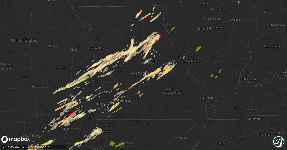
Hail Map in Missouri on May 20, 2013
Get this storm
May 20 map
$229
one time, instant access
Download today. No call, no setup
Keep the $229
Bought the map and want the full workflow? Apply the entire $229 to a subscription within 7 days. None of it is wasted.
Every map, not just this one
This buys you this map. Subscription and you get every map we run, in the markets you choose from a few cities to whole states to nationwide. Plus real-time alerts the moment a storm fires.
Contact data
Name, contact info, occupancy, even credit band for addresses in the footprint. You go from where it hit to who to call.
Become the source they trust
Unlimited branding weather history reports on demand. You already have the documented answer ready for the property owner, and you are the one who showed up with it.
Property data and RoofTrace estimates
Pull up any address you have got, its value and the exact code rules for that jurisdiction, straight from One Click Code. Then RoofTrace estimates the squares, pitch, and roof value, priced the way you price.
Storm reports in Missouri
Missouri
| Date | Description |
|---|---|
| 05/20/20136:57 PM CDT | Time of event estimated. |
| 05/20/20136:57 PM CDT | Trees reported down. |
| 05/20/20136:57 PM CDT | Reports of damage to roof of city hall. |
| 05/20/20136:56 PM CDT | An ef-0 tornado produced up to 80 mph winds and uprooted trees along a half mile long and 200 yard wide path. |
| 05/20/20136:55 PM CDT | Trees down and power outages in and around the vicinity of blue eye. |
| 05/20/20136:55 PM CDT | Tree fell onto house. |
| 05/20/20136:53 PM CDT | 2 large trees blown down in florida |
| 05/20/20136:53 PM CDT | Picture from social media. Time was estimated. |
| 05/20/20136:43 PM CDT | Roof damage to trailer home. |
| 05/20/20136:43 PM CDT | Trees and power lines reported down throughout the county. |
| 05/20/20136:40 PM CDT | Nws storm survey confirmed a tornado was on the ground crossing into missouri from oklahoma and continued to about 0.5 miles southeast of seneca. Numerous trees were sn |
| 05/20/20136:40 PM CDT | One inch hail fell at the intersection of highways d and dd. |
| 05/20/20136:37 PM CDT | An ef-0 tornado touched down about 3 miles south of stockton along east 1674 road. This tornado continued on a 2.1 mile long path through orleans trail public use area |
| 05/20/20136:35 PM CDT | Half dollar size hail on the northeast side of columbia |
| 05/20/20136:34 PM CDT | Barn blown into trailer home and damaged trailer. |
| 05/20/20136:34 PM CDT | A local report indicates 2.00 inch wind near 2 S GERALD |
| 05/20/20136:34 PM CDT | A local report indicates 1.25 inch wind near 1 NE MURRY |
| 05/20/20136:30 PM CDT | Dime to quarter |
| 05/20/20136:25 PM CDT | Hail caused damage to trees and minor damage to several vehicles. |
| 05/20/20136:25 PM CDT | Hail 1.5 miles east of columbia on hwy 63 near hwy ww. |
| 05/20/20136:23 PM CDT | 1 inch to 1.5 inch diameter hail. About 1 mile north of highway m and highway w. |
| 05/20/20136:21 PM CDT | Hail 1.5 miles east of columbia on hwy 63 near hwy ww. |
| 05/20/20136:20 PM CDT | Possible tornado. Damage to outbuildings along with trees and power lines down. Survey team to finish evaluation tomorrow. |
| 05/20/20136:18 PM CDT | A local report indicates 1.00 inch wind near MADISON |
| 05/20/20136:17 PM CDT | Hail lasted for 2 to 3 minutes and ended at 617 pm cdt |
| 05/20/20136:15 PM CDT | Roof damage to building at intersection of highway c and f approximately 3 miles northeast of lamar. |
| 05/20/20136:15 PM CDT | Several bldgs damaged. Roofs in lamar by estimated 75 mph winds. |
| 05/20/20136:15 PM CDT | A local report indicates 1.00 inch wind near 5 E MOBERLY |
| 05/20/20136:08 PM CDT | 1.0 inch hail reported by trained spotter |
| 05/20/20136:03 PM CDT | An ef-1 tornado touched down 7 miles west northwest of lamar...and tracked 6.78 miles to the northeast. Trees along with a couple of outbuildings were destroyed. Estima |
| 05/20/20135:52 PM CDT | Hail reported just north of belle near intersection of highway 89 and highway y |
| 05/20/20135:51 PM CDT | Relayed by county emergency management. |
| 05/20/20135:37 PM CDT | An ef-0 tornado touched down about 3 miles south of stockton along east 1674 road. This tornado continued on a 2.1 mile long path through orleans trail public use area |
| 05/20/20135:36 PM CDT | A local report indicates 1.50 inch wind near 2 N VIENNA |
| 05/20/20135:20 PM CDT | Time corrected...possible tornado. Damage to outbuildings along with trees and power lines down. Survey team to finish evaluation tomorrow. |
| 05/20/20135:06 PM CDT | A local report indicates 1.50 inch wind near IBERIA |
| 05/20/20134:35 PM CDT | Time estimated. |
| 05/20/20134:20 PM CDT | A local report indicates 1.75 inch wind near HOLDEN |
| 05/20/20134:20 PM CDT | A local report indicates 1.00 inch wind near ELDRIDGE |
| 05/20/20134:05 PM CDT | A local report indicates 1.00 inch wind near 3 NNW BENNETT SPRINGS |
| 05/20/20133:45 PM CDT | A local report indicates 1.00 inch wind near HARRISONVILLE |
| 05/20/20133:30 PM CDT | Quarter to half dollar size hail at hwy yy and hwy h |
| 05/20/20133:22 PM CDT | A local report indicates 1.00 inch wind near 6 N DREXEL |
| 05/20/20133:15 PM CDT | A local report indicates 1.75 inch wind near DREXEL |
| 05/20/20138:36 AM CDT | A local report indicates 1.75 inch wind near 7 E AMSTERDAM |
| 05/19/201311:26 PM CDT | 20-25 inch diameter tree down on power lines at the intersection of n mountain and w russel st |
| 05/19/201311:00 PM CDT | Power lines down along carolton street |
| 05/19/201310:55 PM CDT | Power lines and trees down at highway yy and highway 142 |
| 05/19/201310:52 PM CDT | Moderate tree damage |
| 05/19/201310:49 PM CDT | Power outages reported in park hills |
| 05/19/201310:47 PM CDT | Power outages across much of the city of bonne terre |
| 05/19/201310:40 PM CDT | Tree limbs and power lines down in bonne terre and park hills |
| 05/19/201310:39 PM CDT | 10-12 inch diameter tree across highway 49 north of viburnum. |
| 05/19/201310:12 PM CDT | A local report indicates 60 MPH wind near OLIVETTE |
| 05/19/201310:07 PM CDT | Trees and power lines reported down. |
| 05/19/20139:55 PM CDT | Multiple large trees snapped in the winchester area |
| 05/19/20139:47 PM CDT | A local report indicates 69 MPH wind near 4 NNE ORCHARD FARMS |
| 05/19/20139:15 PM CDT | Barn damaged and power lines down on highway z approximately one mile west of highway 5. |
| 05/19/20139:04 PM CDT | A local report indicates 1.25 inch wind near 2 N GROVESPRING |
| 05/19/20139:04 PM CDT | Multiple trees snapped. |
| 05/19/20139:00 PM CDT | Several homes had shingles blown off roof. Small sheds blown over. |
| 05/19/20138:49 PM CDT | Trees reported down. |
| 05/19/20138:46 PM CDT | An ef-0 tornado briefly touched down about 3 miles west northwest of gravois mills uprooting numerous trees and causing minor structural damage. The tornado was 100 yar |
| 05/19/20138:46 PM CDT | Two trees reported down. |
| 05/19/20138:37 PM CDT | A local report indicates 60 MPH wind near 3 SW FORDLAND |
| 05/19/20138:33 PM CDT | Power lines down at mexico and bryan road |
| 05/19/20138:31 PM CDT | Two mobil homes eported damaged from fallen trees. |
| 05/19/20138:29 PM CDT | Dime sized hail as well |
| 05/19/20138:24 PM CDT | A local report indicates 1.00 inch wind near ST. PETERS |
| 05/19/20138:20 PM CDT | Haybarn destroyed. Time of event estimated. |
| 05/19/20138:17 PM CDT | A local report indicates 1.00 inch wind near ST. CHARLES |
| 05/19/20138:17 PM CDT | A local report indicates 1.00 inch wind near HARVESTER |
| 05/19/20138:14 PM CDT | A few trees were down by high winds in californa mo. |
| 05/19/20138:12 PM CDT | 1 tree blown down |
| 05/19/20138:10 PM CDT | Power outages reported at highway f and 65 north of branson. |
| 05/19/20138:10 PM CDT | Wind damage to shingles and siding to a couple of hotels on west side of branson. |
| 05/19/20138:09 PM CDT | Nuimerous branches downed. Wind speed 55 mph. |
| 05/19/20138:09 PM CDT | Roof blown off mobil home into power lines near 438 highway and highway mm. |
| 05/19/20138:05 PM CDT | An ef-0 tornado 100 yards wide and 0.6 miles long caused some tree damage along its path. Estimated wind speeds were 80 to 85 mph. |
| 05/19/20138:05 PM CDT | Numerous trees reported down in and near reeds spring. Trees also reported down along highway 413. |
| 05/19/20138:05 PM CDT | An ef-1 tornado 100 yards wide and 1.4 miles long uprooted trees along its path. Estimated wind speeds were around 90 mph. |
| 05/19/20138:04 PM CDT | A local report indicates 1.25 inch wind near 2 N GROVESPRING |
| 05/19/20138:04 PM CDT | Damage to siding and shingles to a couple hotels near white water park. |
| 05/19/20138:04 PM CDT | Multiple trees snapped. |
| 05/19/20138:00 PM CDT | Tree and powerlines down at green hills drive and tower road. |
| 05/19/20137:59 PM CDT | A local report indicates 60 MPH wind near BRANSON WEST |
| 05/19/20137:55 PM CDT | Shed collapsed |
| 05/19/20137:50 PM CDT | Delayed report of a tree down near campbell road and nottingham road. |
| 05/19/20137:50 PM CDT | An ef-1 tornado uprooted and damaged trees along its 1.4 mile long path with maximum winds of 110 mph and path width of 200 yards. |
| 05/19/20137:46 PM CDT | An ef-0 tornado briefly touched down about 3 miles west northwest of gravois mills uprooting numerous trees and causing minor structural damage. The tornado was 100 yar |
| 05/19/20137:45 PM CDT | Damage to roof and deck. Trees down. |
| 05/19/20137:40 PM CDT | A local report indicates 60 MPH wind near GRAVOIS MILLS |
| 05/19/20137:36 PM CDT | There are several large trees snapped. - severe danage to two machine sheds near highway mm. Shingles removed at some buildings in downtown area. |
| 05/19/20137:35 PM CDT | A local report indicates 58 MPH wind near HANNIBAL |
| 05/19/20137:32 PM CDT | A small hole in the roof at the hannibal - lagrange science building was uncovered and not the entire roof. |
| 05/19/20137:30 PM CDT | Numerous trees uprooted |
| 05/19/20137:29 PM CDT | A local report indicates a tornado near HANNIBAL |
| 05/19/20137:29 PM CDT | Large limbs blown down |
| 05/19/20137:25 PM CDT | Trees uprooted one quarter mile southeast of airport |
| 05/19/20137:24 PM CDT | Trained spotter reported 1.00 inch hail in union missouri |
| 05/19/20137:20 PM CDT | Possible tornado. Damage to outbuildings along with trees and power lines down. Survey team to finish evaluation tomorrow. |
| 05/19/20137:20 PM CDT | Picture from social media showed a large tree blown down near warsaw. Time was estimated by radar. |
| 05/19/20137:15 PM CDT | Picture from social media of a tree snap and fell on an out building. Time was estimated. |
| 05/19/20137:05 PM CDT | Several large trees blown down and minor structural damage to roof to city hall. Large tree fell on a house. Windows blown out to area cafe. |
| 05/19/20137:02 PM CDT | Emergency manager reports hundreds of trees down throughout the eastern portion of st. Clair county due to straight line winds. |
All States Impacted by Hail Map on May 20, 2013
Cities Impacted by Hail Map on May 20, 2013
- Higbee, MO
- Madison, MO
- Clark, MO
- Moberly, MO
- Hampton, FL
- Gainesville, FL
- Waldo, FL
- Starke, FL
- Bowie, TX
- Chelsea, OK
- Caney, KS
- Copan, OK
- Howard City, MI
- Novinger, MO
- Greentop, MO
- Kirksville, MO
- Grand Rapids, MI
- Belding, MI
- Greenville, MI
- Ada, MI
- Lowell, MI
- Sedan, KS
- Perry, MO
- Stoutsville, MO
- Santa Fe, MO
- Fair Play, MO
- Fayette, MO
- Westville, OK
- Proctor, OK
- Crocker, MO
- Richland, MO
- Meeker, OK
- Mustang, OK
- Bethany, OK
- Choctaw, OK
- Mcloud, OK
- Wheatland, OK
- Harrah, OK
- Newalla, OK
- Oklahoma City, OK
- Jones, OK
- Newcastle, OK
- Wellston, OK
- Norman, OK
- Spencer, OK
- Bradenton, FL
- Talala, OK
- Ninnekah, OK
- Chickasha, OK
- Sullivan, MO
- Leslie, MO
- Beaufort, MO
- Harrisonville, MO
- Garden City, MO
- Ada, OK
- Lebanon, MO
- Windyville, MO
- Tunas, MO
- Eldridge, MO
- Port Charlotte, FL
- Venice, FL
- North Port, FL
- Williamsburg, MI
- Rapid City, MI
- Elk Rapids, MI
- Kewadin, MI
- Madill, OK
- Haslett, MI
- Owensville, MO
- Muenster, TX
- Saint Jo, TX
- Bland, MO
- Belle, MO
- Marlow, OK
- Rush Springs, OK
- Park Hill, OK
- Tahlequah, OK
- Carbon, TX
- Eastland, TX
- Rising Star, TX
- Cisco, TX
- Bartlesville, OK
- Wichita Falls, TX
- Maxwell, IA
- Cambridge, IA
- Bourbon, MO
- Gerald, MO
- New Haven, MO
- Rosebud, MO
- Saint James, MO
- Washington, MO
- Rolla, MO
- Cuba, MO
- Marthasville, MO
- Union, MO
- Vichy, MO
- Dansville, MI
- Williamston, MI
- Webberville, MI
- Newaygo, MI
- Mecosta, MI
- Barryton, MI
- Morley, MI
- White Cloud, MI
- Rodney, MI
- Big Rapids, MI
- Evart, MI
- Stanwood, MI
- Vinita, OK
- Queen City, MO
- Green Castle, MO
- Early, TX
- Purmela, TX
- Hamilton, TX
- Pottsville, TX
- Mullin, TX
- Gatesville, TX
- Brownwood, TX
- Sidney, TX
- Comanche, TX
- Goldthwaite, TX
- Jonesboro, TX
- Zephyr, TX
- May, TX
- Evant, TX
- Gustine, TX
- Blanket, TX
- Priddy, TX
- Sturgeon, MO
- Saint George, SC
- Bowman, SC
- Chico, TX
- Jacksboro, TX
- Northport, MI
- Foster, OK
- Elmore City, OK
- Laingsburg, MI
- Swoope, VA
- Rockford, MI
- Sasakwa, OK
- Rich Hill, MO
- Butler, MO
- Osceola, MO
- Deepwater, MO
- Rockville, MO
- Hume, MO
- Montrose, MO
- Appleton City, MO
- Clinton, MO
- Stonewall, OK
- Boyne City, MI
- Traverse City, MI
- Interlochen, MI
- Pawhuska, OK
- Duncan, OK
- Afton, IA
- Creston, IA
- Lorimor, IA
- Shannon City, IA
- Winterset, IA
- Macksburg, IA
- Comanche, OK
- Skiatook, OK
- Barnsdall, OK
- Ramona, OK
- Centralia, MO
- Beaverton, MI
- Edmore, MI
- Stratford, OK
- Lachine, MI
- De Leon, TX
- Bois D Arc, MO
- Fulton, MO
- Lutz, FL
- Dade City, FL
- Land O'Lakes, FL
- Wesley Chapel, FL
- San Antonio, FL
- Mason, MI
- Deland, FL
- Slater, MO
- Glasgow, MO
- Pilot Grove, MO
- Sedalia, MO
- Hughesville, MO
- New Franklin, MO
- Sweet Springs, MO
- Houstonia, MO
- Blackwater, MO
- Franklin, MO
- La Monte, MO
- Arrow Rock, MO
- Smithton, MO
- Gilliam, MO
- Nelson, MO
- Marshall, MO
- Davenport, FL
- Kissimmee, FL
- Lueders, TX
- Albany, TX
- Franklin, NC
- Sylva, NC
- Suttons Bay, MI
- Coffeyville, KS
- Springer, OK
- Ardmore, OK
- Brookfield, MO
- New Boston, MO
- Aurora, MO
- Marionville, MO
- Verona, MO
- Miami, OK
- Wyandotte, OK
- Clarksville, MI
- Saranac, MI
- Alto, MI
- Vienna, MO
- Dixon, MO
- Columbia, MO
- Auxvasse, MO
- Croswell, MI
- Welch, OK
- Holdenville, OK
- Rose City, MI
- West Branch, MI
- South Branch, MI
- Lupton, MI
- Fair Grove, MO
- Pleasant Hope, MO
- Springfield, MO
- Curran, MI
- Hubbard Lake, MI
- Barton City, MI
- Cement, OK
- Alex, OK
- Blanchard, OK
- Wapanucka, OK
- Milburn, OK
- Tupelo, OK
- Iberia, MO
- Saint Elizabeth, MO
- Tuscumbia, MO
- Flushing, MI
- Montrose, MI
- Mexico, MO
- Eufaula, OK
- Independence, KS
- De Leon Springs, FL
- Wilson, OK
- Severy, KS
- Howard, KS
- Fall River, KS
- Piedmont, KS
- Gladwin, MI
- Alger, MI
- Glencoe, OK
- Stillwater, OK
- Windermere, FL
- Orlando, FL
- Winter Garden, FL
- Hawthorne, FL
- Granby, MO
- Pierce City, MO
- Carthage, MO
- Sarcoxie, MO
- Nocona, TX
- Cullowhee, NC
- Decker, MI
- Apopka, FL
- Altamonte Springs, FL
- Ocoee, FL
- Lake Mary, FL
- Longwood, FL
- Brinktown, MO
- Brumley, MO
- Meta, MO
- Newburg, MO
- Argyle, MO
- Stoutland, MO
- Long Lane, MO
- Montreal, MO
- Buffalo, MO
- Ubly, MI
- East Jordan, MI
- Boyne Falls, MI
- Kalkaska, MI
- Fife Lake, MI
- Belmont, MI
- Wynnewood, OK
- Edmond, OK
- Parrish, FL
- Myakka City, FL
- Lamar, MO
- Liberal, MO
- Fort Gibson, OK
- Hulbert, OK
- Reed City, MI
- Paris, MI
- Hersey, MI
- Mound City, KS
- Blairstown, MO
- Adrian, MO
- Warrensburg, MO
- Foster, MO
- Creighton, MO
- La Cygne, KS
- Centerview, MO
- Chilhowee, MO
- Amsterdam, MO
- Amoret, MO
- Archie, MO
- Holden, MO
- Pleasanton, KS
- Leon, OK
- Coalgate, OK
- Republic, MO
- Westphalia, KS
- Garnett, KS
- Welda, KS
- Braggs, OK
- Muskogee, OK
- Morriston, FL
- Inglis, FL
- Bronson, FL
- Sumner, MI
- Van Meter, IA
- Waukee, IA
- Dallas Center, IA
- Adel, IA
- De Soto, IA
- Breckenridge, TX
- Moran, KS
- La Harpe, KS
- Yates Center, KS
- Toronto, KS
- Piqua, KS
- Buffalo, KS
- Iola, KS
- Bronson, KS
- Fredonia, KS
- Humboldt, KS
- Kingston, OK
- Willard, MO
- Archer, FL
- Micanopy, FL
- Tishomingo, OK
- Mill Creek, OK
- Concordia, MO
- Fort McCoy, FL
- Jefferson City, MO
- Centertown, MO
- Hartsburg, MO
- Polk City, IA
- Slater, IA
- Alleman, IA
- Huxley, IA
- Lincoln, AR
- Summers, AR
- Ochelata, OK
- Wright City, MO
- Paoli, OK
- Byars, OK
- Maysville, OK
- Pauls Valley, OK
- Lindsay, OK
- Wayne, OK
- Calhoun, MO
- Earleton, FL
- Knob Noster, MO
- Whiteman Air Force Base, MO
- Sparta, MI
- Sand Lake, MI
- Cedar Springs, MI
- Comstock Park, MI
- Ringgold, TX
- Big Cabin, OK
- Elk City, KS
- Riverdale, MI
- Elwell, MI
- Henrietta, TX
- South Boardman, MI
- Au Gres, MI
- Turner, MI
- Owosso, MI
- Corunna, MI
- Carson City, MI
- Perrinton, MI
- Hubbardston, MI
- Middleton, MI
- Prescott, KS
- Urich, MO
- East Lynne, MO
- Blue Mound, KS
- Otterville, MO
- Holliday, MO
- Bunceton, MO
- Paola, KS
- Fontana, KS
- Peculiar, MO
- Pleasant Hill, MO
- Paris, MO
- Centerville, KS
- Louisburg, KS
- Dalton, MO
- Parker, KS
- Boonville, MO
- Drexel, MO
- Colony, KS
- Salisbury, MO
- Leeton, MO
- Grenola, KS
- Freeman, MO
- Kincaid, KS
- Kingsville, MO
- Keytesville, MO
- Cleveland, MO
- Flint, MI
- Burton, MI
- Melvin, MI
- Peck, MI
- Yale, MI
- Brown City, MI
- Baring, MO
- Rutledge, MO
- Memphis, MO
- Edina, MO
- Nevada, IA
- Arbela, MO
- Luray, MO
- Cherryvale, KS
- Liberty, KS
- Bowling Green, FL
- Fort Meade, FL
- Ringling, OK
- Ankeny, IA
- Bondurant, IA
- Des Moines, IA
- Geronimo, OK
- Walters, OK
- Waurika, OK
- Holliday, TX
- Byers, TX
- Randlett, OK
- Temple, OK
- Sheppard Afb, TX
- Ryan, OK
- Healdton, OK
- Montague, TX
- Iowa Park, TX
- Terral, OK
- Petrolia, TX
- Lone Grove, OK
- Bellevue, TX
- Burneyville, OK
- Miami, MO
- Hillman, MI
- Tampa, FL
- Smoaks, SC
- Walterboro, SC
- Reevesville, SC
- Mio, MI
- Fairview, MI
- Orange City, FL
- Sheridan, MI
- Fenwick, MI
- Wolverine, MI
- Lexington, OK
- Rocheport, MO
- Eagle, MI
- Grand Ledge, MI
- Elmira, MI
- Collinsville, OK
- Thompson, MO
- Lohman, MO
- Russellville, MO
- Elkhart, IA
- Ranger, TX
- Caddo, TX
- Strawn, TX
- Comins, MI
- Owendale, MI
- Staunton, VA
- Ocala, FL
- Wooldridge, MO
- Umatilla, FL
- Leesburg, FL
- Ocklawaha, FL
- Meigs, GA
- Oologah, OK
- Siloam Springs, AR
- Saint Johns, MI
- Half Way, MO
- Grimes, IA
- Earlham, IA
- Clive, IA
- Johnston, IA
- Booneville, IA
- West Des Moines, IA
- Urbandale, IA
- Collins, IA
- Granger, IA
- Lenox, IA
- Colo, IA
- Diagonal, IA
- Williamstown, MO
- Newark, MO
- Kahoka, MO
- La Belle, MO
- Knox City, MO
- Watts, OK
- Checotah, OK
- Henryetta, OK
- Oktaha, OK
- Howell, MI
- Fowlerville, MI
- Hallsville, MO
- Prairie Grove, AR
- Fayetteville, AR
- Tustin, MI
- Fairland, OK
- Herron, MI
- Bluejacket, OK
- Stigler, OK
- Grawn, MI
- Mead, OK
- Cherokee, KS
- McCune, KS
- Valrico, FL
- Dover, FL
- Brandon, FL
- Seffner, FL
- Citra, FL
- Homosassa, FL
- Brooksville, FL
- Leslie, AR
- Harrisburg, MO
- Terlton, OK
- Cleveland, OK
- Pierson, FL
- Belle Glade, FL
- Vicksburg, MI
- Lake City, FL
- Clio, MI
- Everton, MO
- Miller, MO
- Jennings, OK
- Vera, OK
- Delaware, OK
- Claremore, OK
- Hominy, OK
- Prue, OK
- Yale, OK
- Osage, OK
- Sperry, OK
- Tulsa, OK
- Owasso, OK
- Maramec, OK
- Nowata, OK
- Cookson, OK
- Arcadia, FL
- Mannsville, OK
- Sulphur, OK
- Walnut Grove, MO
- Aldrich, MO
- Chandler, OK
- Davenport, OK
- Stroud, OK
- Eustis, FL
- Purdy, MO
- Monett, MO
- Lenapah, OK
- Lake, MI
- Farwell, MI
- Sears, MI
- Jasper, MO
- Oronogo, MO
- Hermann, MO
- Billings, MO
- Mount Vernon, MO
- Washburn, MO
- Faxon, OK
- Roff, OK
- Stilwell, OK
- Tyro, KS
- Wann, OK
- Lake City, MI
- Wheaton, MO
- Clare, MI
- Harrison, MI
- Chippewa Lake, MI
- Ames, IA
- Allen, OK
- Anthony, FL
- Silver Springs, FL
- Meridian, OK
- Erie, KS
- Stark, KS
- Shelbina, MO
- Conway, MO
- Grovespring, MO
- Niangua, MO
- Kingdom City, MO
- Stuart, OK
- S Coffeyville, OK
- Oswego, KS
- Perrin, TX
- Goshen, VA
- Grandville, MI
- Byron Center, MI
- Wyoming, MI
- Tuttle, OK
- Thonotosassa, FL
- Saint Patrick, MO
- Lewistown, MO
- Vermilion, OH
- Inverness, FL
- Lecanto, FL
- Mount Pleasant, MI
- Weidman, MI
- Remus, MI
- Sand Springs, OK
- Metter, GA
- Wynona, OK
- Fairfax, OK
- Pawnee, OK
- Bellaire, MI
- Alden, MI
- Mancelona, MI
- Mindenmines, MO
- Windsor, MO
- Graham, TX
- Graford, TX
- Bryson, TX
- Bolivar, MO
- Morrisville, MO
- Sylvania, GA
- Cyril, OK
- Apache, OK
- Bradley, OK
- Purcell, OK
- Fletcher, OK
- Anadarko, OK
- Brashear, MO
- Hurdland, MO
- Asbury, MO
- Columbus, KS
- Pittsburg, KS
- Weir, KS
- Scammon, KS
- Alden, IA
- Dows, IA
- Popejoy, IA
- Hampton, IA
- Latimer, IA
- McBain, MI
- Marion, MI
- Exeter, MO
- Rogers City, MI
- West Augusta, VA
- Lane, KS
- Yukon, OK
- Vestaburg, MI
- Chanute, KS
- Jamestown, MO
- Fort White, FL
- Ithaca, MI
- Fowler, MI
- Statesboro, GA
- High Springs, FL
- Green Ridge, MO
- Durant, OK
- Versailles, IL
- Chambersburg, IL
- Mcalester, OK
- Stark City, MO
- Altamont, KS
- Edna, KS
- Parsons, KS
- Mound Valley, KS
- Lawton, OK
- Humansville, MO
- Central Lake, MI
- Tiger, GA
- Clayton, GA
- Neodesha, KS
- Naples, FL
- Highlands, NC
- Cashiers, NC
- Abilene, TX
- Sanderson, FL
- Stockton, MO
- Petoskey, MI
- Dustin, OK
- Berger, MO
- Marlette, MI
- Lockwood, MO
- Jerico Springs, MO
- Foristell, MO
- Mingo, IA
- Grant, MI
- Pierson, MI
- Kent City, MI
- Sorrento, FL
- Sanford, FL
- Lake Toxaway, NC
- Stotts City, MO
- Kelley, IA
- Madrid, IA
- Lorain, OH
- Ashland, MO
- Greenville, VA
- Caledonia, MI
- Atoka, OK
- Lane, OK
- Six Lakes, MI
- Wauchula, FL
- Bartow, FL
- Uniontown, KS
- Ash Grove, MO
- Alexandria, MO
- Novelty, MO
- Wentworth, MO
- Scotland, TX
- Porum, OK
- Register, GA
- Chattanooga, OK
- Jermyn, TX
- Dewitt, MI
- Lansing, MI
- Manton, MI
- Houghton Lake, MI
- Stella, MO
- Neosho, MO
- Mount Dora, FL
- Mountain Rest, SC
- Wanette, OK
- Canadian, OK
- Lebanon, OK
- Marietta, OK
- Greenfield, MO
- Dadeville, MO
- Linn, MO
- Trufant, MI
- Hartville, MO
- Falcon, MO
- Decorah, IA
- Ossian, IA
- Spring Hill, FL
- Girard, KS
- Cassville, MO
- Roosevelt, OK
- Hale, MI
- Armstrong, MO
- Reeds, MO
- Hudsonville, MI
- Bath, MI
- Ulman, MO
- Havana, KS
- Peru, KS
- Cedar Vale, KS
- Balsam Grove, NC
- Rosman, NC
- Houghton Lake Heights, MI
- Asher, OK
- Konawa, OK
- Dahlonega, GA
- Centrahoma, OK
- Middlebrook, VA
- Fairgrove, MI
- Capac, MI
- Bucyrus, KS
- Diamond, MO
- Camilla, GA
- Doerun, GA
- Sale City, GA
- Depew, OK
- Thayer, KS
- Dunnellon, FL
- Fort Scott, KS
- Zephyrhills, FL
- Gainesville, TX
- Coleman, OK
- Overbrook, OK
- Davis, OK
- Seneca, MO
- Calmar, IA
- Welling, OK
- Council Hill, OK
- Warner, OK
- Clifton, TX
- Valley Mills, TX
- Marceline, MO
- North Star, MI
- McRae Helena, GA
- Weleetka, OK
- Altoona, KS
- Williston, FL
- Osawatomie, KS
- Gorin, MO
- Stanton, MI
- Spiro, OK
- Pocola, OK
- Cameron, OK
- Kenefic, OK
- Sparks, OK
- Scotts, MI
- Swartz Creek, MI
- Cass City, MI
- Carnegie, OK
- Mountain View, OK
- Alpena, MI
- Brighton, MO
- Altoona, IA
- Monroe City, MO
- Benedict, KS
- Arcola, MO
- Kirkman, IA
- Ionia, MI
- Grand Island, FL
- Roseville, IL
- Smithshire, IL
- Swaledale, IA
- New Bloomfield, MO
- Bowling Green, MO
- Cushing, OK
- Glennie, MI
- Englewood, FL
- Mulberry, KS
- Bronaugh, MO
- Sandusky, MI
- Snover, MI
- Dewey, OK
- Niotaze, KS
- Dearing, KS
- Galesburg, KS
- Montgomery City, MO
- Williamsburg, MO
- Hector, AR
- Pelsor, AR
- Gaines, MI
- Alma, MI
- Collins, MO
- Vanderbilt, MI
- Gaylord, MI
- Ona, FL
- Higginsville, MO
- Hunnewell, MO
- Mapleton, KS
- Odessa, MO
- Lakeview, MI
- Blanchard, MI
- Coral, MI
- Lincoln, MO
- Woodward, IA
- Oakford, IL
- Bristow, OK
- Riverview, FL
- Onondaga, MI
- Eaton Rapids, MI
- Ruth, MI
- Minden City, MI
- Flemington, MO
- Wheatland, MO
- Holts Summit, MO
- Wetumka, OK
- Colcord, OK
- Bunch, OK
- Sunset, TX
- Tussy, OK
- Hennepin, OK
- Ratliff City, OK
- Shawnee, OK
- Antlers, OK
- Caddo, OK
- Caney, OK
- Moyers, OK
- Finley, OK
- Washington, OK
- Clever, MO
- Crane, MO
- Galena, MO
- Dunnegan, MO
- Center, MO
- Labadie, MO
- Saint Clair, MO
- Augusta, MO
- Saint Charles, MO
- Saint Peters, MO
- Litchfield, IL
- Dorsey, IL
- Staunton, IL
- Gillespie, IL
- Wilsonville, IL
- Bunker Hill, IL
- Benld, IL
- Shipman, IL
- Mount Olive, IL
- Liberty, IL
- Barry, IL
- Kinderhook, IL
- Plainville, IL
- Rabun Gap, GA
- Fort Atkinson, IA
- West Union, IA
- Mount Vernon, IL
- Sesser, IL
- Mulkeytown, IL
- Tamaroa, IL
- Du Quoin, IL
- Pinckneyville, IL
- Dana, IL
- Minonk, IL
- Benson, IL
- Rutland, IL
- Port Huron, MI
- Fort Gratiot, MI
- Marseilles, IL
- Ottawa, IL
- Grand Ridge, IL
- Manteno, IL
- Bourbonnais, IL
- Peotone, IL
- Manhattan, IL
- Wilmington, IL
- Frankfort, IL
- Monee, IL
- Chicago Ridge, IL
- Alsip, IL
- Orland Park, IL
- Chicago, IL
- Midlothian, IL
- Palos Park, IL
- Palos Heights, IL
- Worth, IL
- Oak Lawn, IL
- Crestwood, IL
- Oak Forest, IL
- Robbins, IL
- Tinley Park, IL
- Thawville, IL
- Gilman, IL
- Onarga, IL
- Zearing, IA
- Union, IA
- New Providence, IA
- Clemons, IA
- Saint Anthony, IA
- Williams, IA
- Saint Charles, IA
- Prole, IA
- Peru, IA
- Norwalk, IA
- Martensdale, IA
- Bevington, IA
- Ozark, AR
- Mulberry, AR
- Ozone, AR
- Altus, AR
- Hagarville, AR
- Lamar, AR
- Hartman, AR
- Clarksville, AR


