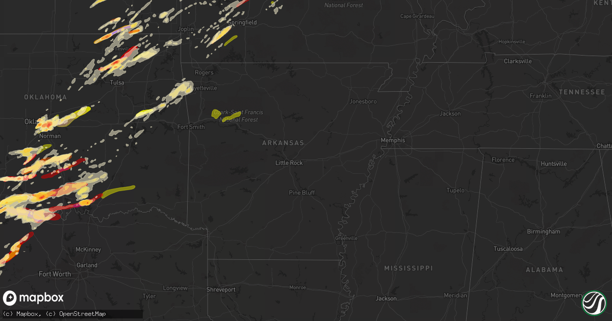
Hail Map in Arkansas on May 20, 2013
Get this storm
May 20 map
$229
one time, instant access
Download today. No call, no setup
Keep the $229
Bought the map and want the full workflow? Apply the entire $229 to a subscription within 7 days. None of it is wasted.
Every map, not just this one
This buys you this map. Subscription and you get every map we run, in the markets you choose from a few cities to whole states to nationwide. Plus real-time alerts the moment a storm fires.
Contact data
Name, contact info, occupancy, even credit band for addresses in the footprint. You go from where it hit to who to call.
Become the source they trust
Unlimited branding weather history reports on demand. You already have the documented answer ready for the property owner, and you are the one who showed up with it.
Property data and RoofTrace estimates
Pull up any address you have got, its value and the exact code rules for that jurisdiction, straight from One Click Code. Then RoofTrace estimates the squares, pitch, and roof value, priced the way you price.
Storm reports in Arkansas
Arkansas
| Date | Description |
|---|---|
| 05/20/20136:49 PM CDT | Photo of a small tornado received. Tree damage was reported in the area. Time estimated via radar. |
| 05/20/20135:20 AM CDT | A tree was blown down. |
| 05/20/20135:00 AM CDT | Limbs were blown down. |
| 05/20/20134:12 AM CDT | Limbs were blown down. |
| 05/20/20133:14 AM CDT | Trees and power lines were blown down. A tree was on a house...and a roof was peeled off a storage shed. |
| 05/20/20133:13 AM CDT | Several power poles down just south of heber springs. |
| 05/20/20131:30 AM CDT | A local report indicates 60 MPH wind near JONESBORO |
| 05/20/20131:18 AM CDT | Tree limbs also down. |
| 05/20/201312:48 AM CDT | A local report indicates 58 MPH wind near NEWPORT AIR INDSTRL PK |
| 05/20/201312:35 AM CDT | A local report indicates 65 MPH wind near OIL TROUGH |
| 05/20/201312:12 AM CDT | Trees down...barn damaged...and both a camper and a mobile home were blown over on dripping springs road 2 miles southeast of steprock. |
| 05/20/201312:10 AM CDT | Trees were blown down. |
| 05/19/201311:55 PM CDT | Trees have been blown over as well as several tree limbs. |
| 05/19/201310:40 PM CDT | Trees down on highway 88 at sims. |
| 05/19/201310:17 PM CDT | Trees down in mill creek area of london. |
| 05/19/201310:10 PM CDT | A local report indicates 1.00 inch wind near HARMONY |
| 05/19/201310:00 PM CDT | A local report indicates 1.00 inch wind near COAL HILL |
| 05/19/20139:56 PM CDT | Nickel to quarter size hail |
| 05/19/20139:49 PM CDT | Debris blocking the intersection of highways 96 and 23. |
| 05/19/20139:49 PM CDT | Trees and power lines downed. |
| 05/19/20139:48 PM CDT | Trees down |
| 05/19/20139:44 PM CDT | Oak bend road blocked by downed trees near intersection with highway 96. |
| 05/19/20139:35 PM CDT | Small trees and branches down on highway 23 near the franklin/logan county line. |
| 05/19/20139:17 PM CDT | 3 to 4 foot tree snapped at its base. |
| 05/19/20139:15 PM CDT | Structure had windows blown out on washington street...several power outages reported...multiple trees down across county |
| 05/19/20138:37 PM CDT | Large tree down on the side of the road. |
| 05/19/20138:00 PM CDT | Tree down |
| 05/19/20137:40 PM CDT | A local report indicates 80 MPH wind near EUREKA SPRINGS |
| 05/19/20137:40 PM CDT | Spotter reported several six inch diameter trees either blown over or snapped off at 10 ft level. Wind estimate of 65 to 75 mph. |
| 05/19/20137:37 PM CDT | Several large trees and power poles down...numerous limb damage |
| 05/19/20137:29 PM CDT | Several large trees down...one tree fell through roof |
| 05/19/20137:25 PM CDT | Tree down on a house. |
| 05/19/20137:21 PM CDT | Aslo reported pea size hail |
| 05/19/20137:21 PM CDT | Tree down on a house. |
| 05/19/20137:21 PM CDT | Nws survey indicated an ef-1 tornado occurred in the rocky branch area. Several mobile homes were significantly damaged including numerous trees downed. Time estimated |
| 05/19/20137:17 PM CDT | A local report indicates 70 MPH wind near SPRINGDALE |
| 05/19/20137:16 PM CDT | Widespread wind damage across town. Numerous large trees downed and damaged. Power lines and power poles damaged. |
| 05/19/20137:15 PM CDT | Measured 61 mph gust at the bentonville municipal airport |
| 05/19/20137:15 PM CDT | Measured 69 mph wind gust near the springdale airport. |
| 05/19/20137:13 PM CDT | *** 1 fatal *** debris struck vehicle. |
| 05/19/20137:12 PM CDT | A local report indicates 65 MPH wind near BENTONVILLE |
| 05/19/20137:06 PM CDT | One structure was destroyed |
All States Impacted by Hail Map on May 20, 2013
Cities Impacted by Hail Map on May 20, 2013
- Higbee, MO
- Madison, MO
- Clark, MO
- Moberly, MO
- Hampton, FL
- Gainesville, FL
- Waldo, FL
- Starke, FL
- Bowie, TX
- Chelsea, OK
- Caney, KS
- Copan, OK
- Howard City, MI
- Novinger, MO
- Greentop, MO
- Kirksville, MO
- Grand Rapids, MI
- Belding, MI
- Greenville, MI
- Ada, MI
- Lowell, MI
- Sedan, KS
- Perry, MO
- Stoutsville, MO
- Santa Fe, MO
- Fair Play, MO
- Fayette, MO
- Westville, OK
- Proctor, OK
- Crocker, MO
- Richland, MO
- Meeker, OK
- Mustang, OK
- Bethany, OK
- Choctaw, OK
- Mcloud, OK
- Wheatland, OK
- Harrah, OK
- Newalla, OK
- Oklahoma City, OK
- Jones, OK
- Newcastle, OK
- Wellston, OK
- Norman, OK
- Spencer, OK
- Bradenton, FL
- Talala, OK
- Ninnekah, OK
- Chickasha, OK
- Sullivan, MO
- Leslie, MO
- Beaufort, MO
- Harrisonville, MO
- Garden City, MO
- Ada, OK
- Lebanon, MO
- Windyville, MO
- Tunas, MO
- Eldridge, MO
- Port Charlotte, FL
- Venice, FL
- North Port, FL
- Williamsburg, MI
- Rapid City, MI
- Elk Rapids, MI
- Kewadin, MI
- Madill, OK
- Haslett, MI
- Owensville, MO
- Muenster, TX
- Saint Jo, TX
- Bland, MO
- Belle, MO
- Marlow, OK
- Rush Springs, OK
- Park Hill, OK
- Tahlequah, OK
- Carbon, TX
- Eastland, TX
- Rising Star, TX
- Cisco, TX
- Bartlesville, OK
- Wichita Falls, TX
- Maxwell, IA
- Cambridge, IA
- Bourbon, MO
- Gerald, MO
- New Haven, MO
- Rosebud, MO
- Saint James, MO
- Washington, MO
- Rolla, MO
- Cuba, MO
- Marthasville, MO
- Union, MO
- Vichy, MO
- Dansville, MI
- Williamston, MI
- Webberville, MI
- Newaygo, MI
- Mecosta, MI
- Barryton, MI
- Morley, MI
- White Cloud, MI
- Rodney, MI
- Big Rapids, MI
- Evart, MI
- Stanwood, MI
- Vinita, OK
- Queen City, MO
- Green Castle, MO
- Early, TX
- Purmela, TX
- Hamilton, TX
- Pottsville, TX
- Mullin, TX
- Gatesville, TX
- Brownwood, TX
- Sidney, TX
- Comanche, TX
- Goldthwaite, TX
- Jonesboro, TX
- Zephyr, TX
- May, TX
- Evant, TX
- Gustine, TX
- Blanket, TX
- Priddy, TX
- Sturgeon, MO
- Saint George, SC
- Bowman, SC
- Chico, TX
- Jacksboro, TX
- Northport, MI
- Foster, OK
- Elmore City, OK
- Laingsburg, MI
- Swoope, VA
- Rockford, MI
- Sasakwa, OK
- Rich Hill, MO
- Butler, MO
- Osceola, MO
- Deepwater, MO
- Rockville, MO
- Hume, MO
- Montrose, MO
- Appleton City, MO
- Clinton, MO
- Stonewall, OK
- Boyne City, MI
- Traverse City, MI
- Interlochen, MI
- Pawhuska, OK
- Duncan, OK
- Afton, IA
- Creston, IA
- Lorimor, IA
- Shannon City, IA
- Winterset, IA
- Macksburg, IA
- Comanche, OK
- Skiatook, OK
- Barnsdall, OK
- Ramona, OK
- Centralia, MO
- Beaverton, MI
- Edmore, MI
- Stratford, OK
- Lachine, MI
- De Leon, TX
- Bois D Arc, MO
- Fulton, MO
- Lutz, FL
- Dade City, FL
- Land O'Lakes, FL
- Wesley Chapel, FL
- San Antonio, FL
- Mason, MI
- Deland, FL
- Slater, MO
- Glasgow, MO
- Pilot Grove, MO
- Sedalia, MO
- Hughesville, MO
- New Franklin, MO
- Sweet Springs, MO
- Houstonia, MO
- Blackwater, MO
- Franklin, MO
- La Monte, MO
- Arrow Rock, MO
- Smithton, MO
- Gilliam, MO
- Nelson, MO
- Marshall, MO
- Davenport, FL
- Kissimmee, FL
- Lueders, TX
- Albany, TX
- Franklin, NC
- Sylva, NC
- Suttons Bay, MI
- Coffeyville, KS
- Springer, OK
- Ardmore, OK
- Brookfield, MO
- New Boston, MO
- Aurora, MO
- Marionville, MO
- Verona, MO
- Miami, OK
- Wyandotte, OK
- Clarksville, MI
- Saranac, MI
- Alto, MI
- Vienna, MO
- Dixon, MO
- Columbia, MO
- Auxvasse, MO
- Croswell, MI
- Welch, OK
- Holdenville, OK
- Rose City, MI
- West Branch, MI
- South Branch, MI
- Lupton, MI
- Fair Grove, MO
- Pleasant Hope, MO
- Springfield, MO
- Curran, MI
- Hubbard Lake, MI
- Barton City, MI
- Cement, OK
- Alex, OK
- Blanchard, OK
- Wapanucka, OK
- Milburn, OK
- Tupelo, OK
- Iberia, MO
- Saint Elizabeth, MO
- Tuscumbia, MO
- Flushing, MI
- Montrose, MI
- Mexico, MO
- Eufaula, OK
- Independence, KS
- De Leon Springs, FL
- Wilson, OK
- Severy, KS
- Howard, KS
- Fall River, KS
- Piedmont, KS
- Gladwin, MI
- Alger, MI
- Glencoe, OK
- Stillwater, OK
- Windermere, FL
- Orlando, FL
- Winter Garden, FL
- Hawthorne, FL
- Granby, MO
- Pierce City, MO
- Carthage, MO
- Sarcoxie, MO
- Nocona, TX
- Cullowhee, NC
- Decker, MI
- Apopka, FL
- Altamonte Springs, FL
- Ocoee, FL
- Lake Mary, FL
- Longwood, FL
- Brinktown, MO
- Brumley, MO
- Meta, MO
- Newburg, MO
- Argyle, MO
- Stoutland, MO
- Long Lane, MO
- Montreal, MO
- Buffalo, MO
- Ubly, MI
- East Jordan, MI
- Boyne Falls, MI
- Kalkaska, MI
- Fife Lake, MI
- Belmont, MI
- Wynnewood, OK
- Edmond, OK
- Parrish, FL
- Myakka City, FL
- Lamar, MO
- Liberal, MO
- Fort Gibson, OK
- Hulbert, OK
- Reed City, MI
- Paris, MI
- Hersey, MI
- Mound City, KS
- Blairstown, MO
- Adrian, MO
- Warrensburg, MO
- Foster, MO
- Creighton, MO
- La Cygne, KS
- Centerview, MO
- Chilhowee, MO
- Amsterdam, MO
- Amoret, MO
- Archie, MO
- Holden, MO
- Pleasanton, KS
- Leon, OK
- Coalgate, OK
- Republic, MO
- Westphalia, KS
- Garnett, KS
- Welda, KS
- Braggs, OK
- Muskogee, OK
- Morriston, FL
- Inglis, FL
- Bronson, FL
- Sumner, MI
- Van Meter, IA
- Waukee, IA
- Dallas Center, IA
- Adel, IA
- De Soto, IA
- Breckenridge, TX
- Moran, KS
- La Harpe, KS
- Yates Center, KS
- Toronto, KS
- Piqua, KS
- Buffalo, KS
- Iola, KS
- Bronson, KS
- Fredonia, KS
- Humboldt, KS
- Kingston, OK
- Willard, MO
- Archer, FL
- Micanopy, FL
- Tishomingo, OK
- Mill Creek, OK
- Concordia, MO
- Fort McCoy, FL
- Jefferson City, MO
- Centertown, MO
- Hartsburg, MO
- Polk City, IA
- Slater, IA
- Alleman, IA
- Huxley, IA
- Lincoln, AR
- Summers, AR
- Ochelata, OK
- Wright City, MO
- Paoli, OK
- Byars, OK
- Maysville, OK
- Pauls Valley, OK
- Lindsay, OK
- Wayne, OK
- Calhoun, MO
- Earleton, FL
- Knob Noster, MO
- Whiteman Air Force Base, MO
- Sparta, MI
- Sand Lake, MI
- Cedar Springs, MI
- Comstock Park, MI
- Ringgold, TX
- Big Cabin, OK
- Elk City, KS
- Riverdale, MI
- Elwell, MI
- Henrietta, TX
- South Boardman, MI
- Au Gres, MI
- Turner, MI
- Owosso, MI
- Corunna, MI
- Carson City, MI
- Perrinton, MI
- Hubbardston, MI
- Middleton, MI
- Prescott, KS
- Urich, MO
- East Lynne, MO
- Blue Mound, KS
- Otterville, MO
- Holliday, MO
- Bunceton, MO
- Paola, KS
- Fontana, KS
- Peculiar, MO
- Pleasant Hill, MO
- Paris, MO
- Centerville, KS
- Louisburg, KS
- Dalton, MO
- Parker, KS
- Boonville, MO
- Drexel, MO
- Colony, KS
- Salisbury, MO
- Leeton, MO
- Grenola, KS
- Freeman, MO
- Kincaid, KS
- Kingsville, MO
- Keytesville, MO
- Cleveland, MO
- Flint, MI
- Burton, MI
- Melvin, MI
- Peck, MI
- Yale, MI
- Brown City, MI
- Baring, MO
- Rutledge, MO
- Memphis, MO
- Edina, MO
- Nevada, IA
- Arbela, MO
- Luray, MO
- Cherryvale, KS
- Liberty, KS
- Bowling Green, FL
- Fort Meade, FL
- Ringling, OK
- Ankeny, IA
- Bondurant, IA
- Des Moines, IA
- Geronimo, OK
- Walters, OK
- Waurika, OK
- Holliday, TX
- Byers, TX
- Randlett, OK
- Temple, OK
- Sheppard Afb, TX
- Ryan, OK
- Healdton, OK
- Montague, TX
- Iowa Park, TX
- Terral, OK
- Petrolia, TX
- Lone Grove, OK
- Bellevue, TX
- Burneyville, OK
- Miami, MO
- Hillman, MI
- Tampa, FL
- Smoaks, SC
- Walterboro, SC
- Reevesville, SC
- Mio, MI
- Fairview, MI
- Orange City, FL
- Sheridan, MI
- Fenwick, MI
- Wolverine, MI
- Lexington, OK
- Rocheport, MO
- Eagle, MI
- Grand Ledge, MI
- Elmira, MI
- Collinsville, OK
- Thompson, MO
- Lohman, MO
- Russellville, MO
- Elkhart, IA
- Ranger, TX
- Caddo, TX
- Strawn, TX
- Comins, MI
- Owendale, MI
- Staunton, VA
- Ocala, FL
- Wooldridge, MO
- Umatilla, FL
- Leesburg, FL
- Ocklawaha, FL
- Meigs, GA
- Oologah, OK
- Siloam Springs, AR
- Saint Johns, MI
- Half Way, MO
- Grimes, IA
- Earlham, IA
- Clive, IA
- Johnston, IA
- Booneville, IA
- West Des Moines, IA
- Urbandale, IA
- Collins, IA
- Granger, IA
- Lenox, IA
- Colo, IA
- Diagonal, IA
- Williamstown, MO
- Newark, MO
- Kahoka, MO
- La Belle, MO
- Knox City, MO
- Watts, OK
- Checotah, OK
- Henryetta, OK
- Oktaha, OK
- Howell, MI
- Fowlerville, MI
- Hallsville, MO
- Prairie Grove, AR
- Fayetteville, AR
- Tustin, MI
- Fairland, OK
- Herron, MI
- Bluejacket, OK
- Stigler, OK
- Grawn, MI
- Mead, OK
- Cherokee, KS
- McCune, KS
- Valrico, FL
- Dover, FL
- Brandon, FL
- Seffner, FL
- Citra, FL
- Homosassa, FL
- Brooksville, FL
- Leslie, AR
- Harrisburg, MO
- Terlton, OK
- Cleveland, OK
- Pierson, FL
- Belle Glade, FL
- Vicksburg, MI
- Lake City, FL
- Clio, MI
- Everton, MO
- Miller, MO
- Jennings, OK
- Vera, OK
- Delaware, OK
- Claremore, OK
- Hominy, OK
- Prue, OK
- Yale, OK
- Osage, OK
- Sperry, OK
- Tulsa, OK
- Owasso, OK
- Maramec, OK
- Nowata, OK
- Cookson, OK
- Arcadia, FL
- Mannsville, OK
- Sulphur, OK
- Walnut Grove, MO
- Aldrich, MO
- Chandler, OK
- Davenport, OK
- Stroud, OK
- Eustis, FL
- Purdy, MO
- Monett, MO
- Lenapah, OK
- Lake, MI
- Farwell, MI
- Sears, MI
- Jasper, MO
- Oronogo, MO
- Hermann, MO
- Billings, MO
- Mount Vernon, MO
- Washburn, MO
- Faxon, OK
- Roff, OK
- Stilwell, OK
- Tyro, KS
- Wann, OK
- Lake City, MI
- Wheaton, MO
- Clare, MI
- Harrison, MI
- Chippewa Lake, MI
- Ames, IA
- Allen, OK
- Anthony, FL
- Silver Springs, FL
- Meridian, OK
- Erie, KS
- Stark, KS
- Shelbina, MO
- Conway, MO
- Grovespring, MO
- Niangua, MO
- Kingdom City, MO
- Stuart, OK
- S Coffeyville, OK
- Oswego, KS
- Perrin, TX
- Goshen, VA
- Grandville, MI
- Byron Center, MI
- Wyoming, MI
- Tuttle, OK
- Thonotosassa, FL
- Saint Patrick, MO
- Lewistown, MO
- Vermilion, OH
- Inverness, FL
- Lecanto, FL
- Mount Pleasant, MI
- Weidman, MI
- Remus, MI
- Sand Springs, OK
- Metter, GA
- Wynona, OK
- Fairfax, OK
- Pawnee, OK
- Bellaire, MI
- Alden, MI
- Mancelona, MI
- Mindenmines, MO
- Windsor, MO
- Graham, TX
- Graford, TX
- Bryson, TX
- Bolivar, MO
- Morrisville, MO
- Sylvania, GA
- Cyril, OK
- Apache, OK
- Bradley, OK
- Purcell, OK
- Fletcher, OK
- Anadarko, OK
- Brashear, MO
- Hurdland, MO
- Asbury, MO
- Columbus, KS
- Pittsburg, KS
- Weir, KS
- Scammon, KS
- Alden, IA
- Dows, IA
- Popejoy, IA
- Hampton, IA
- Latimer, IA
- McBain, MI
- Marion, MI
- Exeter, MO
- Rogers City, MI
- West Augusta, VA
- Lane, KS
- Yukon, OK
- Vestaburg, MI
- Chanute, KS
- Jamestown, MO
- Fort White, FL
- Ithaca, MI
- Fowler, MI
- Statesboro, GA
- High Springs, FL
- Green Ridge, MO
- Durant, OK
- Versailles, IL
- Chambersburg, IL
- Mcalester, OK
- Stark City, MO
- Altamont, KS
- Edna, KS
- Parsons, KS
- Mound Valley, KS
- Lawton, OK
- Humansville, MO
- Central Lake, MI
- Tiger, GA
- Clayton, GA
- Neodesha, KS
- Naples, FL
- Highlands, NC
- Cashiers, NC
- Abilene, TX
- Sanderson, FL
- Stockton, MO
- Petoskey, MI
- Dustin, OK
- Berger, MO
- Marlette, MI
- Lockwood, MO
- Jerico Springs, MO
- Foristell, MO
- Mingo, IA
- Grant, MI
- Pierson, MI
- Kent City, MI
- Sorrento, FL
- Sanford, FL
- Lake Toxaway, NC
- Stotts City, MO
- Kelley, IA
- Madrid, IA
- Lorain, OH
- Ashland, MO
- Greenville, VA
- Caledonia, MI
- Atoka, OK
- Lane, OK
- Six Lakes, MI
- Wauchula, FL
- Bartow, FL
- Uniontown, KS
- Ash Grove, MO
- Alexandria, MO
- Novelty, MO
- Wentworth, MO
- Scotland, TX
- Porum, OK
- Register, GA
- Chattanooga, OK
- Jermyn, TX
- Dewitt, MI
- Lansing, MI
- Manton, MI
- Houghton Lake, MI
- Stella, MO
- Neosho, MO
- Mount Dora, FL
- Mountain Rest, SC
- Wanette, OK
- Canadian, OK
- Lebanon, OK
- Marietta, OK
- Greenfield, MO
- Dadeville, MO
- Linn, MO
- Trufant, MI
- Hartville, MO
- Falcon, MO
- Decorah, IA
- Ossian, IA
- Spring Hill, FL
- Girard, KS
- Cassville, MO
- Roosevelt, OK
- Hale, MI
- Armstrong, MO
- Reeds, MO
- Hudsonville, MI
- Bath, MI
- Ulman, MO
- Havana, KS
- Peru, KS
- Cedar Vale, KS
- Balsam Grove, NC
- Rosman, NC
- Houghton Lake Heights, MI
- Asher, OK
- Konawa, OK
- Dahlonega, GA
- Centrahoma, OK
- Middlebrook, VA
- Fairgrove, MI
- Capac, MI
- Bucyrus, KS
- Diamond, MO
- Camilla, GA
- Doerun, GA
- Sale City, GA
- Depew, OK
- Thayer, KS
- Dunnellon, FL
- Fort Scott, KS
- Zephyrhills, FL
- Gainesville, TX
- Coleman, OK
- Overbrook, OK
- Davis, OK
- Seneca, MO
- Calmar, IA
- Welling, OK
- Council Hill, OK
- Warner, OK
- Clifton, TX
- Valley Mills, TX
- Marceline, MO
- North Star, MI
- McRae Helena, GA
- Weleetka, OK
- Altoona, KS
- Williston, FL
- Osawatomie, KS
- Gorin, MO
- Stanton, MI
- Spiro, OK
- Pocola, OK
- Cameron, OK
- Kenefic, OK
- Sparks, OK
- Scotts, MI
- Swartz Creek, MI
- Cass City, MI
- Carnegie, OK
- Mountain View, OK
- Alpena, MI
- Brighton, MO
- Altoona, IA
- Monroe City, MO
- Benedict, KS
- Arcola, MO
- Kirkman, IA
- Ionia, MI
- Grand Island, FL
- Roseville, IL
- Smithshire, IL
- Swaledale, IA
- New Bloomfield, MO
- Bowling Green, MO
- Cushing, OK
- Glennie, MI
- Englewood, FL
- Mulberry, KS
- Bronaugh, MO
- Sandusky, MI
- Snover, MI
- Dewey, OK
- Niotaze, KS
- Dearing, KS
- Galesburg, KS
- Montgomery City, MO
- Williamsburg, MO
- Hector, AR
- Pelsor, AR
- Gaines, MI
- Alma, MI
- Collins, MO
- Vanderbilt, MI
- Gaylord, MI
- Ona, FL
- Higginsville, MO
- Hunnewell, MO
- Mapleton, KS
- Odessa, MO
- Lakeview, MI
- Blanchard, MI
- Coral, MI
- Lincoln, MO
- Woodward, IA
- Oakford, IL
- Bristow, OK
- Riverview, FL
- Onondaga, MI
- Eaton Rapids, MI
- Ruth, MI
- Minden City, MI
- Flemington, MO
- Wheatland, MO
- Holts Summit, MO
- Wetumka, OK
- Colcord, OK
- Bunch, OK
- Sunset, TX
- Tussy, OK
- Hennepin, OK
- Ratliff City, OK
- Shawnee, OK
- Antlers, OK
- Caddo, OK
- Caney, OK
- Moyers, OK
- Finley, OK
- Washington, OK
- Clever, MO
- Crane, MO
- Galena, MO
- Dunnegan, MO
- Center, MO
- Labadie, MO
- Saint Clair, MO
- Augusta, MO
- Saint Charles, MO
- Saint Peters, MO
- Litchfield, IL
- Dorsey, IL
- Staunton, IL
- Gillespie, IL
- Wilsonville, IL
- Bunker Hill, IL
- Benld, IL
- Shipman, IL
- Mount Olive, IL
- Liberty, IL
- Barry, IL
- Kinderhook, IL
- Plainville, IL
- Rabun Gap, GA
- Fort Atkinson, IA
- West Union, IA
- Mount Vernon, IL
- Sesser, IL
- Mulkeytown, IL
- Tamaroa, IL
- Du Quoin, IL
- Pinckneyville, IL
- Dana, IL
- Minonk, IL
- Benson, IL
- Rutland, IL
- Port Huron, MI
- Fort Gratiot, MI
- Marseilles, IL
- Ottawa, IL
- Grand Ridge, IL
- Manteno, IL
- Bourbonnais, IL
- Peotone, IL
- Manhattan, IL
- Wilmington, IL
- Frankfort, IL
- Monee, IL
- Chicago Ridge, IL
- Alsip, IL
- Orland Park, IL
- Chicago, IL
- Midlothian, IL
- Palos Park, IL
- Palos Heights, IL
- Worth, IL
- Oak Lawn, IL
- Crestwood, IL
- Oak Forest, IL
- Robbins, IL
- Tinley Park, IL
- Thawville, IL
- Gilman, IL
- Onarga, IL
- Zearing, IA
- Union, IA
- New Providence, IA
- Clemons, IA
- Saint Anthony, IA
- Williams, IA
- Saint Charles, IA
- Prole, IA
- Peru, IA
- Norwalk, IA
- Martensdale, IA
- Bevington, IA
- Ozark, AR
- Mulberry, AR
- Ozone, AR
- Altus, AR
- Hagarville, AR
- Lamar, AR
- Hartman, AR
- Clarksville, AR


