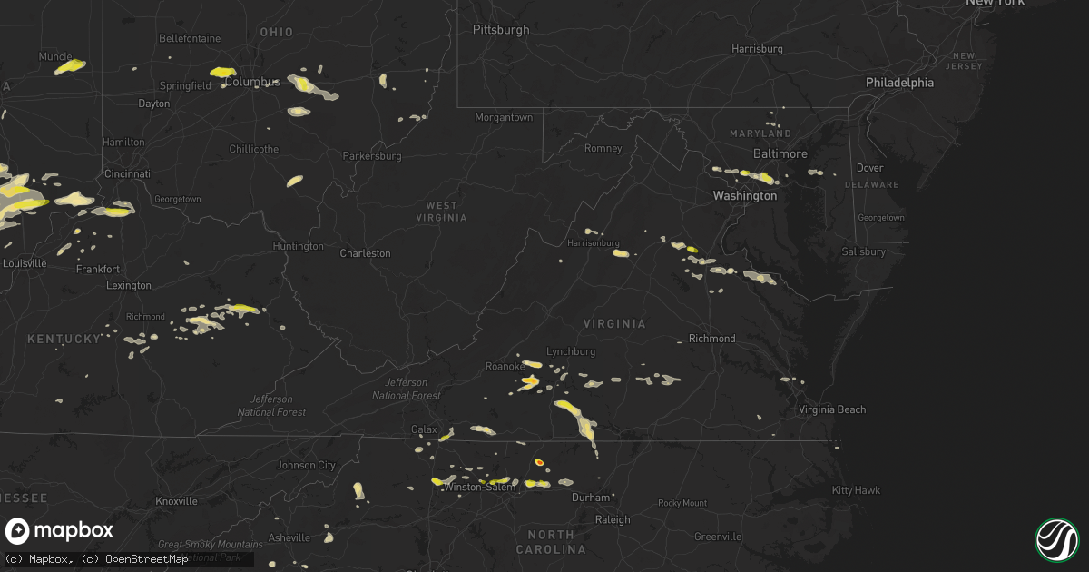
Hail Map in Virginia on May 19, 2017
Get this storm
May 19 map
$229
one time, instant access
Download today. No call, no setup
Keep the $229
Bought the map and want the full workflow? Apply the entire $229 to a subscription within 7 days. None of it is wasted.
Every map, not just this one
This buys you this map. Subscription and you get every map we run, in the markets you choose from a few cities to whole states to nationwide. Plus real-time alerts the moment a storm fires.
Contact data
Name, contact info, occupancy, even credit band for addresses in the footprint. You go from where it hit to who to call.
Become the source they trust
Unlimited branding weather history reports on demand. You already have the documented answer ready for the property owner, and you are the one who showed up with it.
Property data and RoofTrace estimates
Pull up any address you have got, its value and the exact code rules for that jurisdiction, straight from One Click Code. Then RoofTrace estimates the squares, pitch, and roof value, priced the way you price.
Storm reports in Virginia
Virginia
| Date | Description |
|---|---|
| 05/19/20175:57 PM CDT | A tree down on finchs hill rd. |
| 05/19/20175:23 PM CDT | One tree down on sparta rd. |
| 05/19/20175:15 PM CDT | Trees down on va route 3 between potomac mills and the intersection of route 3 and longwood road. |
| 05/19/20174:38 PM CDT | Hail tore leaves off trees and made pock marks in copper roof |
| 05/19/20174:35 PM CDT | 4 trees were reported down in the town of clarksville. |
| 05/19/20174:30 PM CDT | Thunderstorm winds brought down numerous trees within and around the community of virgilina. |
| 05/19/20174:13 PM CDT | Thunderstorm winds resulted in several fallen trees within the community of scottsburg. |
| 05/19/20174:05 PM CDT | Thunderstorm winds downed a tree along horseshoe trail. |
| 05/19/20174:02 PM CDT | Thunderstorm winds resulted in downed trees and large branches along 501 northbound. |
| 05/19/20173:54 PM CDT | Thunderstorm winds downed powerlines within the city of halifax. |
| 05/19/20173:52 PM CDT | Tree down on leavells crossing drive at woodland drive |
| 05/19/20173:50 PM CDT | Nickel to quarter size hail |
| 05/19/20173:33 PM CDT | Multiple trees downed... Some on power lines |
| 05/19/20173:31 PM CDT | Tree fell on a powerline and caught on fire. |
| 05/19/20173:29 PM CDT | Thunderstorm winds downed several large trees onto a powerline along va route 666. |
| 05/19/20173:17 PM CDT | Trees reported down in the area |
| 05/19/20173:17 PM CDT | Tree down on ruth road |
| 05/19/20173:07 PM CDT | Several reports of trees down in the wolftown area |
| 05/19/20173:05 PM CDT | Two medium size trees down at green hills country club and another tree down on route 619 |
| 05/19/20172:54 PM CDT | Several trees and large limbs down in the area |
| 05/19/20172:53 PM CDT | Several trees down across roadways in the turkey ridge area. Hail of unknown size. |
| 05/19/20172:52 PM CDT | Tree down on wilkinson rd near dinwiddie. |
| 05/19/20172:50 PM CDT | Tree down on glebe rd. |
| 05/19/20172:48 PM CDT | A local report indicates 1.00 inch wind near 1 E RICHARDSVILLE |
| 05/19/20171:45 PM CDT | Time estimated by radar. |
| 05/19/20171:30 PM CDT | Tree down on house in holly hills subdivision. |
| 05/19/20171:08 PM CDT | A local report indicates 1.00 inch wind near 1 NW CANA |
| 05/19/201712:44 PM CDT | Tree down on red house road |
| 05/19/201712:31 PM CDT | Tree fell on a car at intersection of east ferry road and marysville road |
| 05/19/201712:29 PM CDT | One tree down on cody road |
| 05/19/201712:24 PM CDT | One tree fell on a vehicle at the intersection of marysville road and east ferry road |
| 05/19/201712:13 PM CDT | Thunderstorm winds resulted in a downed tree across falling creek road. |
| 05/19/201712:07 PM CDT | Thunderstorm winds knocked down large tree limbs across prospect road near the community of hurt. |
| 05/19/201712:06 PM CDT | A local report indicates 1.00 inch wind near 4 S BEDFORD |
| 05/19/201712:06 PM CDT | A local report indicates 1.25 inch wind near 3 S BEDFORD |
| 05/19/201712:03 PM CDT | Thunderstorm winds resulted in a downed tree across falling creek road. |
| 05/19/201711:03 AM CDT | One tree down at the intersection of chestnut hill road and washboard road |
| 05/19/201710:59 AM CDT | One tree down along muse field road |
| 05/18/201711:35 PM CDT | Several trees and powerlines down in the rocky fork and indian creek communities. |
All States Impacted by Hail Map on May 19, 2017
Cities Impacted by Hail Map on May 19, 2017
- Marion, NC
- Pocahontas, AR
- Patrick Springs, VA
- Ozona, TX
- Salem, AR
- Rocky Mount, VA
- Alton, VA
- South Boston, VA
- Quitman, AR
- Greenbrier, AR
- Lancaster, OH
- Sugar Grove, OH
- Logan, OH
- Junction City, OH
- Bremen, OH
- Republic, MO
- Claremore, OK
- Chelsea, OK
- Avoca, TX
- Lueders, TX
- Stamford, TX
- Salem, IN
- Austin, IN
- Scottsburg, IN
- Paris Crossing, IN
- Commiskey, IN
- Crothersville, IN
- Brownstown, IN
- Deputy, IN
- Vallonia, IN
- Naylor, MO
- Neelyville, MO
- Conway, AR
- Campbellsburg, IN
- Hamlin, TX
- Newcastle, TX
- Haskell, TX
- Anson, TX
- Throckmorton, TX
- Sylvester, TX
- San Angelo, TX
- Rocksprings, TX
- Collettsville, NC
- Peabody, KS
- Sperryville, VA
- Floyd, VA
- Scipio, IN
- Seymour, IN
- Campbellsville, KY
- Gustine, TX
- Comanche, TX
- Hot Springs Village, AR
- Cannelton, IN
- Tell City, IN
- Bronte, TX
- Evington, VA
- Lynch Station, VA
- Mead, OK
- Cartwright, OK
- Calera, OK
- Pottsboro, TX
- Kingston, OK
- Heath, OH
- Jacksontown, OH
- Hebron, OH
- Thornville, OH
- Christoval, TX
- Eldorado, TX
- Aspermont, TX
- Hartford, KY
- Utica, KY
- Wirtz, VA
- Terral, OK
- Ryan, OK
- Olney, TX
- Hulbert, OK
- Fort Gibson, OK
- Wagoner, OK
- Hanna, OK
- Dustin, OK
- Corydon, IN
- Protem, MO
- Theodosia, MO
- Rueter, MO
- Ava, MO
- Healdton, OK
- Ringling, OK
- Wilson, OK
- Springer, OK
- Santa Anna, TX
- Coleman, TX
- Gouldbusk, TX
- Campton, KY
- Slade, KY
- Stanton, KY
- Beattyville, KY
- Rogers, KY
- Eden, TX
- Caldwell, KS
- Poolesville, MD
- Beallsville, MD
- Jayton, TX
- Old Glory, TX
- Tahlequah, OK
- Welling, OK
- Henrietta, TX
- Wellington, KY
- Art, TX
- Mason, TX
- Mounds, OK
- Beggs, OK
- Holliday, TX
- Rule, TX
- Seymour, TX
- Wanette, OK
- Burrton, KS
- Moundridge, KS
- Greensboro, NC
- Grandin, MO
- Ellsinore, MO
- Powhatan, VA
- Abilene, KS
- Stephenville, TX
- Bloomington, IN
- Bowling Green, KY
- Burkburnett, TX
- Mitchell, IN
- Orleans, IN
- Bedford, IN
- Roxboro, NC
- Freeland, MD
- Menard, TX
- Hext, TX
- Brady, TX
- Burlington, NC
- Elon, NC
- Locust Grove, OK
- Flippin, AR
- Hamptonville, NC
- Yadkinville, NC
- Boonville, NC
- Davis, OK
- Okmulgee, OK
- Morris, OK
- Depauw, IN
- New Haven, MO
- Leslie, MO
- Washington, MO
- Brownwood, TX
- Franklin, AR
- Temple, OK
- Walters, OK
- Comanche, OK
- Duncan, OK
- Big Spring, TX
- Bristow, OK
- Okemah, OK
- Del Rio, TX
- Rochester, TX
- O'Brien, TX
- Weinert, TX
- Munday, TX
- Evening Shade, AR
- Horseshoe Bend, AR
- Holton, IN
- Versailles, IN
- Wichita Falls, TX
- Huntington, AR
- Chouteau, OK
- Kinsale, VA
- Hurricane, WV
- Sod, WV
- Griffithsville, WV
- Mullin, TX
- Eola, TX
- Wall, TX
- Mereta, TX
- Goodfellow Afb, TX
- Brookesmith, TX
- Rochelle, TX
- Paint Rock, TX
- Bangs, TX
- Vancourt, TX
- Early, TX
- Valera, TX
- Millersview, TX
- Rowena, TX
- Ballinger, TX
- Miles, TX
- Voss, TX
- Fort George G Meade, MD
- Laurel, MD
- Beltsville, MD
- Burtonsville, MD
- Odenton, MD
- Bowie, MD
- Gambrills, MD
- Crofton, MD
- Silver Spring, MD
- Ward, AR
- Cabot, AR
- Beebe, AR
- Lonoke, AR
- Austin, AR
- Ada, OK
- Wellington, KS
- Norton, TX
- Winters, TX
- Talpa, TX
- Walnut Ridge, AR
- Cedar Grove, NC
- Mebane, NC
- Efland, NC
- Glade Hill, VA
- Lead Hill, AR
- Harrison, AR
- Sonora, TX
- McLeansville, NC
- Gibsonville, NC
- Abilene, TX
- Comstock, TX
- Graham, TX
- Spencer, IN
- Worthington, IN
- Freedom, IN
- Coal City, IN
- Florence, KS
- Crittenden, KY
- Dry Ridge, KY
- Bellevue, TX
- Richardsville, VA
- Fredericksburg, VA
- Fort Cobb, OK
- Elmore City, OK
- Pauls Valley, OK
- Spotsylvania, VA
- Shelbyville, KY
- Jonesboro, TX
- Hico, TX
- Hamilton, TX
- Brevard, NC
- Sweetwater, TX
- Roscoe, TX
- Windthorst, TX
- Colorado City, TX
- Loraine, TX
- Merkel, TX
- McCaulley, TX
- Albany, TX
- Westbrook, TX
- Roby, TX
- Altamont, IL
- Doss, TX
- Fredericksburg, TX
- Tobaccoville, NC
- East Bend, NC
- Pfafftown, NC
- Milford, VA
- Barnett, MO
- Versailles, MO
- Bexar, AR
- Sturkie, AR
- Ash Flat, AR
- Violet Hill, AR
- Oxford, AR
- Wiseman, AR
- Glencoe, AR
- Camp, AR
- West Plains, MO
- Stilwell, OK
- Bono, AR
- Jonesboro, AR
- Medford, OK
- Devol, OK
- Randlett, OK
- Sardis, OH
- Battletown, KY
- Payneville, KY
- Brandenburg, KY
- Hennepin, OK
- Ratliff City, OK
- Tussy, OK
- Foster, OK
- Weiner, AR
- Cash, AR
- Carlton, TX
- West Jefferson, OH
- Plain City, OH
- Mechanicsburg, OH
- London, OH
- Irwin, OH
- Nashville, IN
- Gosport, IN
- Solsberry, IN
- Bloomfield, IN
- Ellettsville, IN
- Clay City, IN
- Gladys, VA
- Brookneal, VA
- Lore City, OH
- Salesville, OH
- Senecaville, OH
- Vevay, IN
- Bennington, IN
- Fairfax, OK
- Highland, IL
- Pleasureville, KY
- Lockport, KY
- Central City, KY
- Bremen, KY
- Judsonia, AR
- Kensett, AR
- Searcy, AR
- Palestine, TX
- Iowa Park, TX
- Tishomingo, OK
- Mill Creek, OK
- Stonewall, OK
- Milburn, OK
- Jefferson City, MO
- Russellville, MO
- Olean, MO
- Eldon, MO
- Eugene, MO
- Henley, MO
- San Saba, TX
- Holdenville, OK
- Wewoka, OK
- Greenville, IN
- Pekin, IN
- Borden, IN
- Reidsville, NC
- Hilliard, OH
- Viola, AR
- Garden City, TX
- Bunch, OK
- Denison, TX
- Floral, AR
- Concord, AR
- Owenton, KY
- New Castle, IN
- Muncie, IN
- Selma, IN
- Parker City, IN
- Losantville, IN
- Mooreland, IN
- Siloam, NC
- Colbert, OK
- Grantsburg, IN
- English, IN
- Neosho, MO
- Berea, KY
- Springfield, MO
- De Valls Bluff, AR
- Franklin, VA
- Zuni, VA
- Carrsville, VA
- Billings, MO
- Goldthwaite, TX
- Doole, TX
- Rockwood, TX
- Richland Springs, TX
- Novice, TX
- Mertzon, TX
- Melvin, TX
- Zephyr, TX
- Roosevelt, TX
- Lawn, TX
- Goldsboro, TX
- Junction, TX
- Lohn, TX
- Baird, TX
- Tuscola, TX
- Clyde, TX
- Lometa, TX
- Wingate, TX
- Ovalo, TX
- Hardy, VA
- Moneta, VA
- Phillipsburg, KS
- Glade, KS
- Kirwin, KS
- Stockton, KS
- Agra, KS
- Logan, KS
- Centertown, KY
- Milan, KS
- Wyandotte, OK
- Tiff City, MO
- Anderson, MO
- Grove, OK
- Goodman, MO
- Flat Rock, NC
- Hendersonville, NC
- Sadler, TX
- Gordonville, TX
- Eden, NC
- Cullen, VA
- Charlotte Court House, VA
- Keysville, VA
- Locust Grove, VA
- Huddleston, VA
- Newton, KS
- McKee, KY
- Nashport, OH
- Reeds, MO
- Sarcoxie, MO
- Salyersville, KY
- West Liberty, KY
- Hunter, OK
- Rusk, TX
- Byers, TX
- Boynton, OK
- Heltonville, IN
- Norman, IN
- Natural Dam, AR
- Adolphus, KY
- Westmoreland, TN
- Canal Winchester, OH
- Reynoldsburg, OH
- Pickerington, OH
- Columbus, OH
- Haskell, OK
- Summerfield, NC
- Lancaster, KY
- Stanford, KY
- Elmdale, KS
- Strong City, KS
- Cedar Point, KS
- Lincolnville, KS
- Marion, KS
- Loving, TX
- Springport, IN
- Farmland, IN
- Winchester, IN
- Modoc, IN
- Lone Grove, OK
- Graham, OK
- Nocona, TX
- Ringgold, TX
- Waurika, OK
- Ardmore, OK
- Hawley, TX
- Trent, TX
- Tolar, TX
- Ozark, AR
- Zirconia, NC
- Charleston, AR
- Lavaca, AR
- Vilonia, AR
- El Paso, AR
- Goree, TX
- Chestertown, MD
- Centreville, MD
- New Baden, IL
- Germantown, IL
- Trenton, IL
- Tulsa, OK
- Maysville, OK
- Purcell, OK
- Swifton, AR
- Ramsey, IN
- Elkwood, VA
- Lignum, VA
- Stevensburg, VA
- Culpeper, VA
- Elkton, VA
- Stanardsville, VA
- Peggs, OK
- Seneca, MO
- Salina, OK
- Eucha, OK
- Porter, OK
- Catoosa, OK
- South West City, MO
- Pryor, OK
- Muskogee, OK
- Spavinaw, OK
- Bixby, OK
- Colcord, OK
- Jay, OK
- Broken Arrow, OK
- Coweta, OK
- Inola, OK
- Fredonia, KS
- Poteau, OK
- Cameron, OK
- Chester, AR
- Evant, TX
- Gatesville, TX
- Purmela, TX
- Montross, VA
- Gretna, VA
- Vernon Hill, VA
- Nathalie, VA
- Java, VA
- Iredell, TX
- Pottsville, TX
- Milltown, IN
- Marengo, IN
- Sulphur, OK
- Lenoir, NC
- Blowing Rock, NC
- Cedar Hill, TN
- Byars, OK
- Stratford, OK
- Irvine, KY
- Mayfield, KS
- Reisterstown, MD
- Sparks Glencoe, MD
- Upperco, MD
- Kernersville, NC
- Coalgate, OK
- Copperas Cove, TX
- Clifton, TX
- Cranfills Gap, TX
- Park Hill, OK
- Kremlin, OK
- Pond Creek, OK
- Vian, OK
- Gore, OK
- Batesville, AR
- Bald Knob, AR
- Bradford, AR
- Pleasant Plains, AR
- Oil Trough, AR
- Ravenden Springs, AR
- Walnut Springs, TX
- Meridian, TX
- Browns Summit, NC
- Crestwood, KY
- La Grange, KY
- Smithfield, KY
- Lost Springs, KS
- Herington, KS
- Wakita, OK
- Manchester, OK
- Bluff City, KS
- Canaan, IN
- Arkadelphia, AR
- Burkeville, VA
- Meherrin, VA
- Green Bay, VA
- Newark, OH
- Laurelville, OH
- Circleville, OH
- Prestonsburg, KY
- Calumet, OK
- Sasakwa, OK
- Oakland, AR
- Pontiac, MO
- Wellston, OH
- Jackson, OH
- Wetumka, OK
- Wynnewood, OK
- Glenford, OH
- Harrisonburg, VA
- Farmington, PA
- Cedarcreek, MO
- Bradleyville, MO
- Thornfield, MO
- Peel, AR
- Colfax, NC
- Oak Ridge, NC
- Westville, OK
- Summers, AR
- Mayflower, AR
- Wilburn, AR
- Pangburn, AR
- Ropesville, TX
- Stephensport, KY
- Hardinsburg, KY
- Dover, DE
- Mount Vernon, KY
- Brodhead, KY
- Sedgwick, KS
- Nashville, IL
- Robert Lee, TX
- Leavenworth, IN
- Lexington, IN
- Locust Grove, AR
- Sandy Level, VA
- Pinckneyville, IL
- Kingman, KS
- Ashland City, TN
- Chapmansboro, TN
- Center Ridge, AR
- Solgohachia, AR
- Hattieville, AR
- Hardinsburg, IN
- Hartford, AR
- Indianola, OK
- Mcalester, OK
- Mountainburg, AR
- Castell, TX
- London, TX
- Dublin, TX
- Pottersville, MO
- Buhler, KS
- Wasola, MO
- Squires, MO
- Yellville, AR
- Noble, MO
- Waukomis, OK
- Enid, OK
- Canehill, AR
- Little Rock, AR
- England, AR
- Sterling City, TX
- Tunica, MS
- Konawa, OK
- Couch, MO
- Mokane, MO
- Tebbetts, MO
- Fulton, MO
- New Bloomfield, MO
- Port Royal, VA
- Warsaw, VA
- Round Mountain, TX
- Walnut Cove, NC
- Walkertown, NC
- New Salem, PA
- Uniontown, PA
- McClellandtown, PA
- Phenix, VA
- Mount Solon, VA
- Churchville, VA
- Vinton, VA
- Bedford, VA
- Thaxton, VA
- Coila, MS
- Wilsons, VA
- Crewe, VA
- Blackstone, VA
- Lindsay, OK
- Ozark, MO
- Burkesville, KY
- Columbia, KY
- Breeding, KY
- Petrolia, TX
- Jerusalem, AR
- Glenallen, MO
- Marble Hill, MO
- Winston Salem, NC
- Bigelow, AR
- Broadway, VA
- Linville, VA
- Rosie, AR
- Biscoe, AR
- Durant, OK
- Glade Valley, NC
- Atlanta, KS
- Oxford, NC
- Kingfisher, OK
- Pataskala, OH
- Greenfield, MO
- Arcola, MO
- Sweeden, KY
- Bee Spring, KY
- Mammoth Cave, KY
- Stuart, VA
- Critz, VA
- Brookline, MO
- Jacksonville, AR
- Rappahannock Academy, VA
- Wolfforth, TX
- Winfield, KS
- Earlsboro, OK
- Harviell, MO
- Kenefic, OK
- Houston, AR
- Tupelo, OK
- Morrilton, AR
- Lexington, OK
- Noble, OK
- Electra, TX
- Madison, IN
- Florence, IN
- Cross Plains, IN
- Cape Girardeau, MO
- Clever, MO
- Bois D Arc, MO
- Marshall, NC
- Stuttgart, AR
- West Fork, AR
- Evansville, AR
- Prairie Grove, AR
- Rotan, TX
- Alicia, AR
- Hoxie, AR
- Gracemont, OK
- Tiger, GA
- Mountain Grove, MO
- Chaffee, MO
- Scott City, MO
- Zalma, MO
- Elkins, AR
- Huntsville, AR
- Ruther Glen, VA
- Fordsville, KY
- Hurt, VA
- Kensington, KS
- Bogue, KS
- Melbourne, AR
- Rockville, MD
- Springville, IN
- Frazeysburg, OH
- Hebron, NE
- Deshler, NE
- Wynona, OK
- Rome, IN
- Derby, IN
- Roff, OK
- Winslow, AR
- Shawnee, OK
- Hugo, OK
- Fayetteville, AR
- Virgilina, VA
- Halifax, VA
- Mount Vernon, AR
- Enola, AR
- Rice, VA
- New Castle, KY
- Eminence, KY
- Columbus, IN
- North Vernon, IN
- Elizabethtown, IN
- Paint Lick, KY
- Sapulpa, OK
- Advance, NC
- Fisher, AR
- Fairdealing, MO
- Doniphan, MO
- Lower Salem, OH
- Graysville, OH
- Rising Sun, IN
- Williamstown, KY
- Glencoe, KY
- Mount Judea, AR
- Hague, VA
- Colonial Beach, VA
- Covington, TN
- Mason, TN
- Guston, KY
- Mannsville, OK
- Wapello, IA
- Columbus Junction, IA
- Hardy, AR
- Cherokee Village, AR
- Bland, MO
- Whitesboro, TX
- Collinsville, TX
- Jonesville, NC
- De Mossville, KY
- Warsaw, KY
- Harrold, TX
- Galax, VA
- Oakfield, TN
- Jackson, TN
- King George, VA
- Rush Springs, OK
- Marlow, OK
- Edgemont, AR
- Higden, AR
- Woodson, TX
- Alma, AR
- Kinta, OK
- Quaker City, OH
- Perryville, AR
- Fawn Grove, PA
- New Park, PA
- Airville, PA
- Felton, PA
- Sparta, KY
- Drury, MO
- Heber Springs, AR
- Drasco, AR
- Seligman, MO
- Long Island, VA
- Owensburg, IN
- New Harmony, IN
- Wadesville, IN
- Lowgap, NC
- Mount Airy, NC
- Cana, VA
- Sanders, KY
- Falmouth, KY
- Morning View, KY
- Verona, KY
- Walton, KY
- Highlands, NC
- Meeker, OK
- Miller, MO
- Isabella, MO
- Wake Forest, NC
- Brockwell, AR
- Koshkonong, MO
- Beach Haven, NJ
- Barnegat Light, NJ
- Grandfield, OK
- New Salisbury, IN
- Lebanon, MO
- Centerville, TX
- Davidson, OK
- Vinton, OH
- Partridge, KS
- Pretty Prairie, KS
- Arlington, KS
- Hutchinson, KS
- Nixa, MO
- Salem, IL
- Centrahoma, OK
- Turners Station, KY
- State Road, NC
- Elkin, NC
- Fitzhugh, OK
- Dougherty, OK
- Madill, OK
- Atoka, OK
- Fittstown, OK
- Wapanucka, OK
- Coleman, OK
- Hawesville, KY
- Branchville, IN
- Union Star, KY
- Palmyra, IN
- Leopold, IN
- Pinnacle, NC
- Scotland, TX
- Seminole, OK
- Paden, OK
- Pomona, IL
- Murphysboro, IL
- Alto Pass, IL
- Nineveh, IN
- Crab Orchard, KY
- Eufaula, OK
- Tye, TX
- Dyess Afb, TX
- Knotts Island, NC
- Old Fort, NC
- Blue Ridge, VA
- Vinita, OK
- Strang, OK
- Mount Perry, OH
- Jackson, KY
- Germantown, MD
- Boyds, MD
- Dickerson, MD
- Olney, MD
- Lampasas, TX
- Paragould, AR
- Goodview, VA
- Derwood, MD
- Washington Grove, MD
- Gaithersburg, MD
- Paoli, IN
- Fredericksburg, IN
- Linton, IN
- Jasonville, IN
- Freetown, IN
- Dupont, IN
- Medora, IN
- Switz City, IN
- Jonesville, IN
- Beaver Dam, KY
- McHenry, KY
- Mulberry, AR
- Washburn, MO
- Allen, OK
- Harned, KY
- Scotland, AR
- Edgar Springs, MO
- Paoli, OK
- Smith Center, KS
- Forest, VA
- Goode, VA
- Stigler, OK
- Butlerville, IN
- Staffordsville, KY
- Hagerhill, KY
- Norman, OK
- Tecumseh, OK
- Macomb, OK
- Clinton, AR
- Leslie, AR
- Thida, AR
- Poplar Bluff, MO
- Knox City, TX
- Scottsville, KY
- Underwood, IN
- McClure, IL
- Alum Creek, WV
- Milton, WV
- Hamlin, WV
- Culloden, WV
- Sumerco, WV
- Tornado, WV
- West Hamlin, WV
- Coldwater, MS
- Hernando, MS
- Stem, NC
- Rougemont, NC
- Sikeston, MO
- Hillsborough, NC
- Sheppard Afb, TX
- Singers Glen, VA
- Fulks Run, VA
- Atwood, OK
- Lamar, OK
- Calvin, OK
- Griffithville, AR
- Gipsy, MO
- Lowndes, MO
- Leopold, MO
- Yorktown, VA
- Dale, IN
- Saint Meinrad, IN
- Ferdinand, IN
- Huntingburg, IN
- Altavista, VA
- Williamsville, MO
- Greenville, MO
- Pilot Point, TX
- Tioga, TX
- Beaufort, MO
- Gerald, MO
- Ghent, KY
- Lavinia, TN
- Medina, TN
- Milan, TN
- Sherman, TX
- Bradford, OH
- Delaplaine, AR
- O'Kean, AR
- Beech Grove, AR
- Biggers, AR
- Fort Eustis, VA
- Newport News, VA
- Romance, AR
- Deer, AR
- Hackett, AR
- Greenwood, AR
- Sarah, MS
- Kellyville, OK
- Wichita, KS
- Haysville, KS
- Oil Springs, KY
- Hampton, VA
- Atkins, AR
- Moravian Falls, NC
- Woodford, VA
- Spencer, VA
- Meadows Of Dan, VA
- Madison, NC
- Rock Hall, MD
- Somerset, OH
- Granville, OH
- Philo, OH
- Roseville, OH
- Zanesville, OH
- Crooksville, OH
- Buckeye Lake, OH
- Blue Rock, OH
- Castle, OK
- Boley, OK
- Weleetka, OK
- Prague, OK
- Afton, OK
- King, NC
- Reynolds Station, KY
- Granby, MO
- Diamond, MO
- Hominy, OK
- Oolitic, IN
- Leon, KS
- Latham, KS
- Marcella, AR
- Harper, TX
- Nash, OK
- Omaha, AR
- Crane, MO
- Marionville, MO
- Mize, KY
- Hazel Green, KY
- Cannel City, KY
- Laconia, IN
- Rhodelia, KY
- Mauckport, IN
- New Matamoras, OH
- Crownsville, MD
- Okarche, OK
- Saint Paris, OH
- Witts Springs, AR
- Obion, TN
- Clarksville, AR
- Ozone, AR
- Rose, OK
- Valley View, TX
- Springfield, TN
- Bethesda, MD
- North Little Rock, AR
- Hensley, AR
- Scott, AR
- Argonia, KS
- Stuart, OK
- Cecil, AR
- Burkett, TX
- Lohman, MO
- Lawton, OK
- White Hall, MD
- Parkton, MD
- Stewartstown, PA
- Poquoson, VA
- Mammoth Spring, AR
- Maud, OK
- Cleveland, AR
- Hastings, OK
- Archer City, TX
- Jacksboro, TX
- Kiefer, OK
- Success, AR
- Corning, AR
- Dexter, KY
- Murray, KY
- Adair, OK
- Haven, KS
- Chester, IL
- Steeleville, IL
- Belzoni, MS
- Tchula, MS
- Dawson Springs, KY
- Crofton, KY
- Licking, MO
- Beulah, MO
- Hagarville, AR
- Plains, KS
- Sharpsburg, KY
- Owingsville, KY
- Ash Grove, MO
- Jacobsburg, OH
- Belmont, OH
- Greenwood, IN
- Indianapolis, IN
- Plumerville, AR
- Peck, KS
- Oktaha, OK
- Council Hill, OK
- Wideman, AR
- Germanton, NC
- Greenwood, MS
- Carrollton, MS
- Higginson, AR
- Madison, VA
- Cobden, IL
- Jonesboro, IL
- Makanda, IL
- Blanket, TX
- Bokchito, OK
- Trafalgar, IN
- Morgantown, IN
- Spiro, OK
- Bokoshe, OK
- Quinton, OK
- Holts Summit, MO
- Mountain Home, TX
- Severna Park, MD
- Clearwater, KS
- Princeton, KY
- Cerulean, KY
- Junction City, KY
- Dillsboro, IN
- Danville, KY
- Loco, OK
- Sallisaw, OK
- New Martinsville, WV
- Winona, MO
- Tennyson, IN
- McRae, AR
- Hector, AR
- Ararat, VA
- Hillsville, VA
- Lambsburg, VA
- Fancy Gap, VA
- Almyra, AR
- Asher, OK
- Saint Clairsville, OH
- Cunningham, TN
- Suffolk, VA
- Brookland, AR
- Linn, MO
- Loose Creek, MO
- Vancleve, KY
- Zoe, KY
- Ravenna, KY
- Hardin, KY
- Benton, KY
- Dunnville, KY
- Cushing, OK
- Church Hill, MD
- Wappapello, MO
- Muldrow, OK
- Partlow, VA
- Halstead, KS
- Black Oak, AR
- Lake City, AR
- Burden, KS
- Birdseye, IN
- Eckerty, IN
- Felton, DE
- Aurora, MO
- Livermore, KY
- Whitesville, KY
- Carlsbad, TX
- Lubbock, TX
- Sandy Spring, MD
- Ashton, MD
- Spencerville, MD


