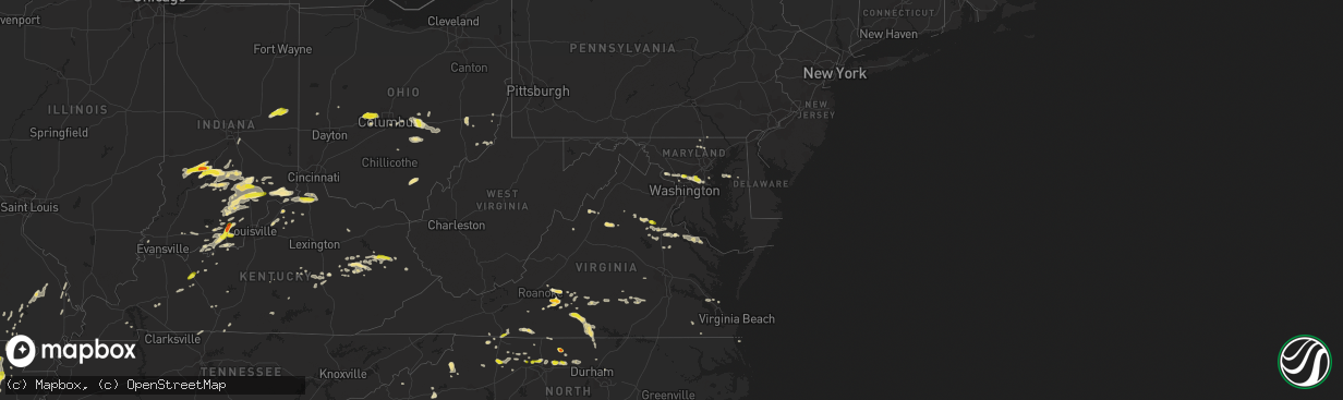
Hail Map in Maryland on May 19, 2017
The weather event in Maryland on May 19, 2017 includes Hail map. 21 states and 1,118 cities were impacted and suffered possible damage. The total estimated number of properties impacted is 3,488.
Want more than just the map?
Turn this storm into a full workflow.
- Owner + property data so you know who to knock
- OnDemand branded weather history reports to win the "did we even have hail?" argument
- RoofTrace estimate so reps stop guessing numbers at the door
Bought this map? Upgrade within 7 days and we'll credit the $230. (10-15 min setup call)
Hail
3,488
Estimated number of impacted properties by a 1.00" hail or larger0
Estimated number of impacted properties by a 1.75" hail or larger0
Estimated number of impacted properties by a 2.50" hail or largerStorm reports in Maryland
Maryland
| Date | Description |
|---|---|
| 05/19/20176:36 PM CDT | Tree down near rutland rd and st. George barber rd |
| 05/19/20176:35 PM CDT | A local report indicates 67 MPH wind near 1 N BELVEDERE HEIGHTS |
| 05/19/20176:24 PM CDT | Tree down near intersection of rt 450 and rt 3 |
| 05/19/20176:12 PM CDT | A local report indicates 58 MPH wind near 2 SW FORT MEADE |
| 05/19/20176:00 PM CDT | Several large branches down at cross creek golf club |
| 05/19/20175:48 PM CDT | A local report indicates 1.00 inch wind near 1 ESE NORBECK |
| 05/19/20175:18 PM CDT | Couple of large limbs down along jerusalem rd between rt 28 and rt 109 |
| 05/18/20179:49 PM CDT | Numerous trees down in the eastern part of the county |
| 05/18/20177:25 PM CDT | Power poles and lines blown down on vehicles in the 1600 block of roberts station road. Time estimated from radar. |
All States Impacted by Hail Map on May 19, 2017
Cities Impacted by Hail Map on May 19, 2017
- Marion, NC
- Pocahontas, AR
- Patrick Springs, VA
- Ozona, TX
- Salem, AR
- Rocky Mount, VA
- Alton, VA
- South Boston, VA
- Quitman, AR
- Greenbrier, AR
- Lancaster, OH
- Sugar Grove, OH
- Logan, OH
- Junction City, OH
- Bremen, OH
- Republic, MO
- Claremore, OK
- Chelsea, OK
- Avoca, TX
- Lueders, TX
- Stamford, TX
- Salem, IN
- Austin, IN
- Scottsburg, IN
- Paris Crossing, IN
- Commiskey, IN
- Crothersville, IN
- Brownstown, IN
- Deputy, IN
- Vallonia, IN
- Naylor, MO
- Neelyville, MO
- Conway, AR
- Campbellsburg, IN
- Hamlin, TX
- Newcastle, TX
- Haskell, TX
- Anson, TX
- Throckmorton, TX
- Sylvester, TX
- San Angelo, TX
- Rocksprings, TX
- Collettsville, NC
- Peabody, KS
- Sperryville, VA
- Floyd, VA
- Scipio, IN
- Seymour, IN
- Campbellsville, KY
- Gustine, TX
- Comanche, TX
- Hot Springs Village, AR
- Cannelton, IN
- Tell City, IN
- Bronte, TX
- Evington, VA
- Lynch Station, VA
- Mead, OK
- Cartwright, OK
- Calera, OK
- Pottsboro, TX
- Kingston, OK
- Heath, OH
- Jacksontown, OH
- Hebron, OH
- Thornville, OH
- Christoval, TX
- Eldorado, TX
- Aspermont, TX
- Hartford, KY
- Utica, KY
- Wirtz, VA
- Terral, OK
- Ryan, OK
- Olney, TX
- Hulbert, OK
- Fort Gibson, OK
- Wagoner, OK
- Hanna, OK
- Dustin, OK
- Corydon, IN
- Protem, MO
- Theodosia, MO
- Rueter, MO
- Ava, MO
- Healdton, OK
- Ringling, OK
- Wilson, OK
- Springer, OK
- Santa Anna, TX
- Coleman, TX
- Gouldbusk, TX
- Campton, KY
- Slade, KY
- Stanton, KY
- Beattyville, KY
- Rogers, KY
- Eden, TX
- Caldwell, KS
- Poolesville, MD
- Beallsville, MD
- Jayton, TX
- Old Glory, TX
- Tahlequah, OK
- Welling, OK
- Henrietta, TX
- Wellington, KY
- Art, TX
- Mason, TX
- Mounds, OK
- Beggs, OK
- Holliday, TX
- Rule, TX
- Seymour, TX
- Wanette, OK
- Burrton, KS
- Moundridge, KS
- Greensboro, NC
- Grandin, MO
- Ellsinore, MO
- Powhatan, VA
- Abilene, KS
- Stephenville, TX
- Bloomington, IN
- Bowling Green, KY
- Burkburnett, TX
- Mitchell, IN
- Orleans, IN
- Bedford, IN
- Roxboro, NC
- Freeland, MD
- Menard, TX
- Hext, TX
- Brady, TX
- Burlington, NC
- Elon, NC
- Locust Grove, OK
- Flippin, AR
- Hamptonville, NC
- Yadkinville, NC
- Boonville, NC
- Davis, OK
- Okmulgee, OK
- Morris, OK
- Depauw, IN
- New Haven, MO
- Leslie, MO
- Washington, MO
- Brownwood, TX
- Franklin, AR
- Temple, OK
- Walters, OK
- Comanche, OK
- Duncan, OK
- Big Spring, TX
- Bristow, OK
- Okemah, OK
- Del Rio, TX
- Rochester, TX
- O'Brien, TX
- Weinert, TX
- Munday, TX
- Evening Shade, AR
- Horseshoe Bend, AR
- Holton, IN
- Versailles, IN
- Wichita Falls, TX
- Huntington, AR
- Chouteau, OK
- Kinsale, VA
- Hurricane, WV
- Sod, WV
- Griffithsville, WV
- Mullin, TX
- Eola, TX
- Wall, TX
- Mereta, TX
- Goodfellow Afb, TX
- Brookesmith, TX
- Rochelle, TX
- Paint Rock, TX
- Bangs, TX
- Vancourt, TX
- Early, TX
- Valera, TX
- Millersview, TX
- Rowena, TX
- Ballinger, TX
- Miles, TX
- Voss, TX
- Fort George G Meade, MD
- Laurel, MD
- Beltsville, MD
- Burtonsville, MD
- Odenton, MD
- Bowie, MD
- Gambrills, MD
- Crofton, MD
- Silver Spring, MD
- Ward, AR
- Cabot, AR
- Beebe, AR
- Lonoke, AR
- Austin, AR
- Ada, OK
- Wellington, KS
- Norton, TX
- Winters, TX
- Talpa, TX
- Walnut Ridge, AR
- Cedar Grove, NC
- Mebane, NC
- Efland, NC
- Glade Hill, VA
- Lead Hill, AR
- Harrison, AR
- Sonora, TX
- McLeansville, NC
- Gibsonville, NC
- Abilene, TX
- Comstock, TX
- Graham, TX
- Spencer, IN
- Worthington, IN
- Freedom, IN
- Coal City, IN
- Florence, KS
- Crittenden, KY
- Dry Ridge, KY
- Bellevue, TX
- Richardsville, VA
- Fredericksburg, VA
- Fort Cobb, OK
- Elmore City, OK
- Pauls Valley, OK
- Spotsylvania, VA
- Shelbyville, KY
- Jonesboro, TX
- Hico, TX
- Hamilton, TX
- Brevard, NC
- Sweetwater, TX
- Roscoe, TX
- Windthorst, TX
- Colorado City, TX
- Loraine, TX
- Merkel, TX
- McCaulley, TX
- Albany, TX
- Westbrook, TX
- Roby, TX
- Altamont, IL
- Doss, TX
- Fredericksburg, TX
- Tobaccoville, NC
- East Bend, NC
- Pfafftown, NC
- Milford, VA
- Barnett, MO
- Versailles, MO
- Bexar, AR
- Sturkie, AR
- Ash Flat, AR
- Violet Hill, AR
- Oxford, AR
- Wiseman, AR
- Glencoe, AR
- Camp, AR
- West Plains, MO
- Stilwell, OK
- Bono, AR
- Jonesboro, AR
- Medford, OK
- Devol, OK
- Randlett, OK
- Sardis, OH
- Battletown, KY
- Payneville, KY
- Brandenburg, KY
- Hennepin, OK
- Ratliff City, OK
- Tussy, OK
- Foster, OK
- Weiner, AR
- Cash, AR
- Carlton, TX
- West Jefferson, OH
- Plain City, OH
- Mechanicsburg, OH
- London, OH
- Irwin, OH
- Nashville, IN
- Gosport, IN
- Solsberry, IN
- Bloomfield, IN
- Ellettsville, IN
- Clay City, IN
- Gladys, VA
- Brookneal, VA
- Lore City, OH
- Salesville, OH
- Senecaville, OH
- Vevay, IN
- Bennington, IN
- Fairfax, OK
- Highland, IL
- Pleasureville, KY
- Lockport, KY
- Central City, KY
- Bremen, KY
- Judsonia, AR
- Kensett, AR
- Searcy, AR
- Palestine, TX
- Iowa Park, TX
- Tishomingo, OK
- Mill Creek, OK
- Stonewall, OK
- Milburn, OK
- Jefferson City, MO
- Russellville, MO
- Olean, MO
- Eldon, MO
- Eugene, MO
- Henley, MO
- San Saba, TX
- Holdenville, OK
- Wewoka, OK
- Greenville, IN
- Pekin, IN
- Borden, IN
- Reidsville, NC
- Hilliard, OH
- Viola, AR
- Garden City, TX
- Bunch, OK
- Denison, TX
- Floral, AR
- Concord, AR
- Owenton, KY
- New Castle, IN
- Muncie, IN
- Selma, IN
- Parker City, IN
- Losantville, IN
- Mooreland, IN
- Siloam, NC
- Colbert, OK
- Grantsburg, IN
- English, IN
- Neosho, MO
- Berea, KY
- Springfield, MO
- De Valls Bluff, AR
- Franklin, VA
- Zuni, VA
- Carrsville, VA
- Billings, MO
- Goldthwaite, TX
- Doole, TX
- Rockwood, TX
- Richland Springs, TX
- Novice, TX
- Mertzon, TX
- Melvin, TX
- Zephyr, TX
- Roosevelt, TX
- Lawn, TX
- Goldsboro, TX
- Junction, TX
- Lohn, TX
- Baird, TX
- Tuscola, TX
- Clyde, TX
- Lometa, TX
- Wingate, TX
- Ovalo, TX
- Hardy, VA
- Moneta, VA
- Phillipsburg, KS
- Glade, KS
- Kirwin, KS
- Stockton, KS
- Agra, KS
- Logan, KS
- Centertown, KY
- Milan, KS
- Wyandotte, OK
- Tiff City, MO
- Anderson, MO
- Grove, OK
- Goodman, MO
- Flat Rock, NC
- Hendersonville, NC
- Sadler, TX
- Gordonville, TX
- Eden, NC
- Cullen, VA
- Charlotte Court House, VA
- Keysville, VA
- Locust Grove, VA
- Huddleston, VA
- Newton, KS
- McKee, KY
- Nashport, OH
- Reeds, MO
- Sarcoxie, MO
- Salyersville, KY
- West Liberty, KY
- Hunter, OK
- Rusk, TX
- Byers, TX
- Boynton, OK
- Heltonville, IN
- Norman, IN
- Natural Dam, AR
- Adolphus, KY
- Westmoreland, TN
- Canal Winchester, OH
- Reynoldsburg, OH
- Pickerington, OH
- Columbus, OH
- Haskell, OK
- Summerfield, NC
- Lancaster, KY
- Stanford, KY
- Elmdale, KS
- Strong City, KS
- Cedar Point, KS
- Lincolnville, KS
- Marion, KS
- Loving, TX
- Springport, IN
- Farmland, IN
- Winchester, IN
- Modoc, IN
- Lone Grove, OK
- Graham, OK
- Nocona, TX
- Ringgold, TX
- Waurika, OK
- Ardmore, OK
- Hawley, TX
- Trent, TX
- Tolar, TX
- Ozark, AR
- Zirconia, NC
- Charleston, AR
- Lavaca, AR
- Vilonia, AR
- El Paso, AR
- Goree, TX
- Chestertown, MD
- Centreville, MD
- New Baden, IL
- Germantown, IL
- Trenton, IL
- Tulsa, OK
- Maysville, OK
- Purcell, OK
- Swifton, AR
- Ramsey, IN
- Elkwood, VA
- Lignum, VA
- Stevensburg, VA
- Culpeper, VA
- Elkton, VA
- Stanardsville, VA
- Peggs, OK
- Seneca, MO
- Salina, OK
- Eucha, OK
- Porter, OK
- Catoosa, OK
- South West City, MO
- Pryor, OK
- Muskogee, OK
- Spavinaw, OK
- Bixby, OK
- Colcord, OK
- Jay, OK
- Broken Arrow, OK
- Coweta, OK
- Inola, OK
- Fredonia, KS
- Poteau, OK
- Cameron, OK
- Chester, AR
- Evant, TX
- Gatesville, TX
- Purmela, TX
- Montross, VA
- Gretna, VA
- Vernon Hill, VA
- Nathalie, VA
- Java, VA
- Iredell, TX
- Pottsville, TX
- Milltown, IN
- Marengo, IN
- Sulphur, OK
- Lenoir, NC
- Blowing Rock, NC
- Cedar Hill, TN
- Byars, OK
- Stratford, OK
- Irvine, KY
- Mayfield, KS
- Reisterstown, MD
- Sparks Glencoe, MD
- Upperco, MD
- Kernersville, NC
- Coalgate, OK
- Copperas Cove, TX
- Clifton, TX
- Cranfills Gap, TX
- Park Hill, OK
- Kremlin, OK
- Pond Creek, OK
- Vian, OK
- Gore, OK
- Batesville, AR
- Bald Knob, AR
- Bradford, AR
- Pleasant Plains, AR
- Oil Trough, AR
- Ravenden Springs, AR
- Walnut Springs, TX
- Meridian, TX
- Browns Summit, NC
- Crestwood, KY
- La Grange, KY
- Smithfield, KY
- Lost Springs, KS
- Herington, KS
- Wakita, OK
- Manchester, OK
- Bluff City, KS
- Canaan, IN
- Arkadelphia, AR
- Burkeville, VA
- Meherrin, VA
- Green Bay, VA
- Newark, OH
- Laurelville, OH
- Circleville, OH
- Prestonsburg, KY
- Calumet, OK
- Sasakwa, OK
- Oakland, AR
- Pontiac, MO
- Wellston, OH
- Jackson, OH
- Wetumka, OK
- Wynnewood, OK
- Glenford, OH
- Harrisonburg, VA
- Farmington, PA
- Cedarcreek, MO
- Bradleyville, MO
- Thornfield, MO
- Peel, AR
- Colfax, NC
- Oak Ridge, NC
- Westville, OK
- Summers, AR
- Mayflower, AR
- Wilburn, AR
- Pangburn, AR
- Ropesville, TX
- Stephensport, KY
- Hardinsburg, KY
- Dover, DE
- Mount Vernon, KY
- Brodhead, KY
- Sedgwick, KS
- Nashville, IL
- Robert Lee, TX
- Leavenworth, IN
- Lexington, IN
- Locust Grove, AR
- Sandy Level, VA
- Pinckneyville, IL
- Kingman, KS
- Ashland City, TN
- Chapmansboro, TN
- Center Ridge, AR
- Solgohachia, AR
- Hattieville, AR
- Hardinsburg, IN
- Hartford, AR
- Indianola, OK
- Mcalester, OK
- Mountainburg, AR
- Castell, TX
- London, TX
- Dublin, TX
- Pottersville, MO
- Buhler, KS
- Wasola, MO
- Squires, MO
- Yellville, AR
- Noble, MO
- Waukomis, OK
- Enid, OK
- Canehill, AR
- Little Rock, AR
- England, AR
- Sterling City, TX
- Tunica, MS
- Konawa, OK
- Couch, MO
- Mokane, MO
- Tebbetts, MO
- Fulton, MO
- New Bloomfield, MO
- Port Royal, VA
- Warsaw, VA
- Round Mountain, TX
- Walnut Cove, NC
- Walkertown, NC
- New Salem, PA
- Uniontown, PA
- McClellandtown, PA
- Phenix, VA
- Mount Solon, VA
- Churchville, VA
- Vinton, VA
- Bedford, VA
- Thaxton, VA
- Coila, MS
- Wilsons, VA
- Crewe, VA
- Blackstone, VA
- Lindsay, OK
- Ozark, MO
- Burkesville, KY
- Columbia, KY
- Breeding, KY
- Petrolia, TX
- Jerusalem, AR
- Glenallen, MO
- Marble Hill, MO
- Winston Salem, NC
- Bigelow, AR
- Broadway, VA
- Linville, VA
- Rosie, AR
- Biscoe, AR
- Durant, OK
- Glade Valley, NC
- Atlanta, KS
- Oxford, NC
- Kingfisher, OK
- Pataskala, OH
- Greenfield, MO
- Arcola, MO
- Sweeden, KY
- Bee Spring, KY
- Mammoth Cave, KY
- Stuart, VA
- Critz, VA
- Brookline, MO
- Jacksonville, AR
- Rappahannock Academy, VA
- Wolfforth, TX
- Winfield, KS
- Earlsboro, OK
- Harviell, MO
- Kenefic, OK
- Houston, AR
- Tupelo, OK
- Morrilton, AR
- Lexington, OK
- Noble, OK
- Electra, TX
- Madison, IN
- Florence, IN
- Cross Plains, IN
- Cape Girardeau, MO
- Clever, MO
- Bois D Arc, MO
- Marshall, NC
- Stuttgart, AR
- West Fork, AR
- Evansville, AR
- Prairie Grove, AR
- Rotan, TX
- Alicia, AR
- Hoxie, AR
- Gracemont, OK
- Tiger, GA
- Mountain Grove, MO
- Chaffee, MO
- Scott City, MO
- Zalma, MO
- Elkins, AR
- Huntsville, AR
- Ruther Glen, VA
- Fordsville, KY
- Hurt, VA
- Kensington, KS
- Bogue, KS
- Melbourne, AR
- Rockville, MD
- Springville, IN
- Frazeysburg, OH
- Hebron, NE
- Deshler, NE
- Wynona, OK
- Rome, IN
- Derby, IN
- Roff, OK
- Winslow, AR
- Shawnee, OK
- Hugo, OK
- Fayetteville, AR
- Virgilina, VA
- Halifax, VA
- Mount Vernon, AR
- Enola, AR
- Rice, VA
- New Castle, KY
- Eminence, KY
- Columbus, IN
- North Vernon, IN
- Elizabethtown, IN
- Paint Lick, KY
- Sapulpa, OK
- Advance, NC
- Fisher, AR
- Fairdealing, MO
- Doniphan, MO
- Lower Salem, OH
- Graysville, OH
- Rising Sun, IN
- Williamstown, KY
- Glencoe, KY
- Mount Judea, AR
- Hague, VA
- Colonial Beach, VA
- Covington, TN
- Mason, TN
- Guston, KY
- Mannsville, OK
- Wapello, IA
- Columbus Junction, IA
- Hardy, AR
- Cherokee Village, AR
- Bland, MO
- Whitesboro, TX
- Collinsville, TX
- Jonesville, NC
- De Mossville, KY
- Warsaw, KY
- Harrold, TX
- Galax, VA
- Oakfield, TN
- Jackson, TN
- King George, VA
- Rush Springs, OK
- Marlow, OK
- Edgemont, AR
- Higden, AR
- Woodson, TX
- Alma, AR
- Kinta, OK
- Quaker City, OH
- Perryville, AR
- Fawn Grove, PA
- New Park, PA
- Airville, PA
- Felton, PA
- Sparta, KY
- Drury, MO
- Heber Springs, AR
- Drasco, AR
- Seligman, MO
- Long Island, VA
- Owensburg, IN
- New Harmony, IN
- Wadesville, IN
- Lowgap, NC
- Mount Airy, NC
- Cana, VA
- Sanders, KY
- Falmouth, KY
- Morning View, KY
- Verona, KY
- Walton, KY
- Highlands, NC
- Meeker, OK
- Miller, MO
- Isabella, MO
- Wake Forest, NC
- Brockwell, AR
- Koshkonong, MO
- Beach Haven, NJ
- Barnegat Light, NJ
- Grandfield, OK
- New Salisbury, IN
- Lebanon, MO
- Centerville, TX
- Davidson, OK
- Vinton, OH
- Partridge, KS
- Pretty Prairie, KS
- Arlington, KS
- Hutchinson, KS
- Nixa, MO
- Salem, IL
- Centrahoma, OK
- Turners Station, KY
- State Road, NC
- Elkin, NC
- Fitzhugh, OK
- Dougherty, OK
- Madill, OK
- Atoka, OK
- Fittstown, OK
- Wapanucka, OK
- Coleman, OK
- Hawesville, KY
- Branchville, IN
- Union Star, KY
- Palmyra, IN
- Leopold, IN
- Pinnacle, NC
- Scotland, TX
- Seminole, OK
- Paden, OK
- Pomona, IL
- Murphysboro, IL
- Alto Pass, IL
- Nineveh, IN
- Crab Orchard, KY
- Eufaula, OK
- Tye, TX
- Dyess Afb, TX
- Knotts Island, NC
- Old Fort, NC
- Blue Ridge, VA
- Vinita, OK
- Strang, OK
- Mount Perry, OH
- Jackson, KY
- Germantown, MD
- Boyds, MD
- Dickerson, MD
- Olney, MD
- Lampasas, TX
- Paragould, AR
- Goodview, VA
- Derwood, MD
- Washington Grove, MD
- Gaithersburg, MD
- Paoli, IN
- Fredericksburg, IN
- Linton, IN
- Jasonville, IN
- Freetown, IN
- Dupont, IN
- Medora, IN
- Switz City, IN
- Jonesville, IN
- Beaver Dam, KY
- McHenry, KY
- Mulberry, AR
- Washburn, MO
- Allen, OK
- Harned, KY
- Scotland, AR
- Edgar Springs, MO
- Paoli, OK
- Smith Center, KS
- Forest, VA
- Goode, VA
- Stigler, OK
- Butlerville, IN
- Staffordsville, KY
- Hagerhill, KY
- Norman, OK
- Tecumseh, OK
- Macomb, OK
- Clinton, AR
- Leslie, AR
- Thida, AR
- Poplar Bluff, MO
- Knox City, TX
- Scottsville, KY
- Underwood, IN
- McClure, IL
- Alum Creek, WV
- Milton, WV
- Hamlin, WV
- Culloden, WV
- Sumerco, WV
- Tornado, WV
- West Hamlin, WV
- Coldwater, MS
- Hernando, MS
- Stem, NC
- Rougemont, NC
- Sikeston, MO
- Hillsborough, NC
- Sheppard Afb, TX
- Singers Glen, VA
- Fulks Run, VA
- Atwood, OK
- Lamar, OK
- Calvin, OK
- Griffithville, AR
- Gipsy, MO
- Lowndes, MO
- Leopold, MO
- Yorktown, VA
- Dale, IN
- Saint Meinrad, IN
- Ferdinand, IN
- Huntingburg, IN
- Altavista, VA
- Williamsville, MO
- Greenville, MO
- Pilot Point, TX
- Tioga, TX
- Beaufort, MO
- Gerald, MO
- Ghent, KY
- Lavinia, TN
- Medina, TN
- Milan, TN
- Sherman, TX
- Bradford, OH
- Delaplaine, AR
- O'Kean, AR
- Beech Grove, AR
- Biggers, AR
- Fort Eustis, VA
- Newport News, VA
- Romance, AR
- Deer, AR
- Hackett, AR
- Greenwood, AR
- Sarah, MS
- Kellyville, OK
- Wichita, KS
- Haysville, KS
- Oil Springs, KY
- Hampton, VA
- Atkins, AR
- Moravian Falls, NC
- Woodford, VA
- Spencer, VA
- Meadows Of Dan, VA
- Madison, NC
- Rock Hall, MD
- Somerset, OH
- Granville, OH
- Philo, OH
- Roseville, OH
- Zanesville, OH
- Crooksville, OH
- Buckeye Lake, OH
- Blue Rock, OH
- Castle, OK
- Boley, OK
- Weleetka, OK
- Prague, OK
- Afton, OK
- King, NC
- Reynolds Station, KY
- Granby, MO
- Diamond, MO
- Hominy, OK
- Oolitic, IN
- Leon, KS
- Latham, KS
- Marcella, AR
- Harper, TX
- Nash, OK
- Omaha, AR
- Crane, MO
- Marionville, MO
- Mize, KY
- Hazel Green, KY
- Cannel City, KY
- Laconia, IN
- Rhodelia, KY
- Mauckport, IN
- New Matamoras, OH
- Crownsville, MD
- Okarche, OK
- Saint Paris, OH
- Witts Springs, AR
- Obion, TN
- Clarksville, AR
- Ozone, AR
- Rose, OK
- Valley View, TX
- Springfield, TN
- Bethesda, MD
- North Little Rock, AR
- Hensley, AR
- Scott, AR
- Argonia, KS
- Stuart, OK
- Cecil, AR
- Burkett, TX
- Lohman, MO
- Lawton, OK
- White Hall, MD
- Parkton, MD
- Stewartstown, PA
- Poquoson, VA
- Mammoth Spring, AR
- Maud, OK
- Cleveland, AR
- Hastings, OK
- Archer City, TX
- Jacksboro, TX
- Kiefer, OK
- Success, AR
- Corning, AR
- Dexter, KY
- Murray, KY
- Adair, OK
- Haven, KS
- Chester, IL
- Steeleville, IL
- Belzoni, MS
- Tchula, MS
- Dawson Springs, KY
- Crofton, KY
- Licking, MO
- Beulah, MO
- Hagarville, AR
- Plains, KS
- Sharpsburg, KY
- Owingsville, KY
- Ash Grove, MO
- Jacobsburg, OH
- Belmont, OH
- Greenwood, IN
- Indianapolis, IN
- Plumerville, AR
- Peck, KS
- Oktaha, OK
- Council Hill, OK
- Wideman, AR
- Germanton, NC
- Greenwood, MS
- Carrollton, MS
- Higginson, AR
- Madison, VA
- Cobden, IL
- Jonesboro, IL
- Makanda, IL
- Blanket, TX
- Bokchito, OK
- Trafalgar, IN
- Morgantown, IN
- Spiro, OK
- Bokoshe, OK
- Quinton, OK
- Holts Summit, MO
- Mountain Home, TX
- Severna Park, MD
- Clearwater, KS
- Princeton, KY
- Cerulean, KY
- Junction City, KY
- Dillsboro, IN
- Danville, KY
- Loco, OK
- Sallisaw, OK
- New Martinsville, WV
- Winona, MO
- Tennyson, IN
- McRae, AR
- Hector, AR
- Ararat, VA
- Hillsville, VA
- Lambsburg, VA
- Fancy Gap, VA
- Almyra, AR
- Asher, OK
- Saint Clairsville, OH
- Cunningham, TN
- Suffolk, VA
- Brookland, AR
- Linn, MO
- Loose Creek, MO
- Vancleve, KY
- Zoe, KY
- Ravenna, KY
- Hardin, KY
- Benton, KY
- Dunnville, KY
- Cushing, OK
- Church Hill, MD
- Wappapello, MO
- Muldrow, OK
- Partlow, VA
- Halstead, KS
- Black Oak, AR
- Lake City, AR
- Burden, KS
- Birdseye, IN
- Eckerty, IN
- Felton, DE
- Aurora, MO
- Livermore, KY
- Whitesville, KY
- Carlsbad, TX
- Lubbock, TX
- Sandy Spring, MD
- Ashton, MD
- Spencerville, MD


