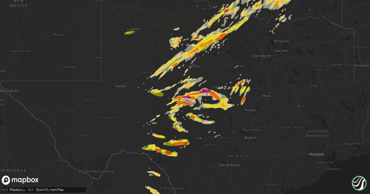
Hail Map on May 19, 2017
Get this storm
May 19 map
$229
one time, instant access
Download today. No call, no setup
Keep the $229
Bought the map and want the full workflow? Apply the entire $229 to a subscription within 7 days. None of it is wasted.
Every map, not just this one
This buys you this map. Subscription and you get every map we run, in the markets you choose from a few cities to whole states to nationwide. Plus real-time alerts the moment a storm fires.
Contact data
Name, contact info, occupancy, even credit band for addresses in the footprint. You go from where it hit to who to call.
Become the source they trust
Unlimited branding weather history reports on demand. You already have the documented answer ready for the property owner, and you are the one who showed up with it.
Property data and RoofTrace estimates
Pull up any address you have got, its value and the exact code rules for that jurisdiction, straight from One Click Code. Then RoofTrace estimates the squares, pitch, and roof value, priced the way you price.
States Impacted by Hail Map on May 19, 2017
Storm reports
Maryland
| Date | Description |
|---|---|
| 05/19/20176:36 PM CDT | Tree down near rutland rd and st. George barber rd |
| 05/19/20176:35 PM CDT | A local report indicates 67 MPH wind near 1 N BELVEDERE HEIGHTS |
| 05/19/20176:24 PM CDT | Tree down near intersection of rt 450 and rt 3 |
| 05/19/20176:12 PM CDT | A local report indicates 58 MPH wind near 2 SW FORT MEADE |
| 05/19/20176:00 PM CDT | Several large branches down at cross creek golf club |
| 05/19/20175:48 PM CDT | A local report indicates 1.00 inch wind near 1 ESE NORBECK |
| 05/19/20175:18 PM CDT | Couple of large limbs down along jerusalem rd between rt 28 and rt 109 |
| 05/18/20179:49 PM CDT | Numerous trees down in the eastern part of the county |
| 05/18/20177:25 PM CDT | Power poles and lines blown down on vehicles in the 1600 block of roberts station road. Time estimated from radar. |
Indiana
| Date | Description |
|---|---|
| 05/19/20173:22 PM CDT | Ef-1 tornado with peak winds of 90 mph. Path length was 0.6 miles and maximum width was 50 yards. Storm survey found all of the damage along old union chapel rd off of |
| 05/19/20173:20 PM CDT | Porch blown off of a mobile home and damage to a metal outbuilding. |
| 05/19/20172:40 PM CDT | Tree down near allensville. Time estimated by radar. |
| 05/19/20172:16 PM CDT | Large tree down along sr 129 near olean rd. Time estimated by radar. |
| 05/19/20172:06 PM CDT | Several tree limbs down in versailles area. Time estimated by radar. |
| 05/19/20171:47 PM CDT | A local report indicates 1.25 inch wind near 4 NNE BLOUNTSVILLE |
| 05/19/20171:45 PM CDT | A local report indicates 1.75 inch wind near DEPAUW |
| 05/19/20171:40 PM CDT | Hail nearly covered ground. |
| 05/19/20171:30 PM CDT | *** 2 inj *** estimated 65 mph wind. Two 53 foot trailers on side. One semi truck with attached 53 foot trailer on side... Driver and passenger sustaining minor injurie |
| 05/19/20171:00 PM CDT | Reported at w 17th street bloomington... In. Received via facebook. |
| 05/19/201712:52 PM CDT | A local report indicates 1.00 inch wind near ELLETTSVILLE |
| 05/19/201712:50 PM CDT | A local report indicates 1.75 inch wind near SPENCER |
| 05/19/201712:50 PM CDT | A local report indicates 1.00 inch wind near 1 WNW INDIANA UNIVERSIT |
| 05/19/201712:30 PM CDT | A local report indicates 1.00 inch wind near FREEDOM |
Tennessee
| Date | Description |
|---|---|
| 05/19/20172:25 PM CDT | A local report indicates 1.25 inch wind near OAKFIELD |
Pennsylvania
| Date | Description |
|---|---|
| 05/19/20174:27 PM CDT | Trees down |
| 05/19/20174:27 PM CDT | Tree down |
| 05/19/20174:15 PM CDT | Trees down |
| 05/19/20172:05 PM CDT | Report of trees and wires down in north hopewell township on faraway drive. |
Kentucky
| Date | Description |
|---|---|
| 05/19/20175:15 PM CDT | Several trees down near dogwalk rd. Tree fell on carport. Barn damaged. Time estimated by radar. |
| 05/19/20174:36 PM CDT | Large tree limbs down and pea size hail. |
| 05/19/20174:07 PM CDT | A local report indicates 1.00 inch wind near 1 NW HARTFORD |
| 05/19/20173:35 PM CDT | A local report indicates 1.00 inch wind near CRITTENDEN |
| 05/19/20178:40 AM CDT | Large tree limb downed. Estimated wind gust of 40 mph. |
| 05/19/20177:55 AM CDT | Trees and power lines down. |
| 05/18/20179:52 PM CDT | Tree down on straight fork road. Time estimated by radar |
| 05/18/20179:44 PM CDT | Tree down around mile marker 2 on ky 114. |
| 05/18/20179:42 PM CDT | A tree was reported to have been downed. |
| 05/18/20179:40 PM CDT | Large limb blown down. |
| 05/18/20179:40 PM CDT | A local report indicates 1.00 inch wind near 2 ESE IVYTON |
| 05/18/20179:39 PM CDT | Tree down near mile marker 23 on highway 30. |
| 05/18/20179:35 PM CDT | Tree down around mile marker 2 on ky 114. Corrected location and time from earlier report. |
| 05/18/20179:20 PM CDT | Large limb down on richmond st. North of downtown. |
| 05/18/20179:16 PM CDT | A treee and a large limb was blown down. |
| 05/18/20179:15 PM CDT | Large limbs were blown down. |
| 05/18/20178:42 PM CDT | A tree was reported to have been downed. |
| 05/18/20178:40 PM CDT | A local report indicates 1.25 inch wind near ROGERS |
Virginia
| Date | Description |
|---|---|
| 05/19/20175:57 PM CDT | A tree down on finchs hill rd. |
| 05/19/20175:23 PM CDT | One tree down on sparta rd. |
| 05/19/20175:15 PM CDT | Trees down on va route 3 between potomac mills and the intersection of route 3 and longwood road. |
| 05/19/20174:38 PM CDT | Hail tore leaves off trees and made pock marks in copper roof |
| 05/19/20174:35 PM CDT | 4 trees were reported down in the town of clarksville. |
| 05/19/20174:30 PM CDT | Thunderstorm winds brought down numerous trees within and around the community of virgilina. |
| 05/19/20174:13 PM CDT | Thunderstorm winds resulted in several fallen trees within the community of scottsburg. |
| 05/19/20174:05 PM CDT | Thunderstorm winds downed a tree along horseshoe trail. |
| 05/19/20174:02 PM CDT | Thunderstorm winds resulted in downed trees and large branches along 501 northbound. |
| 05/19/20173:54 PM CDT | Thunderstorm winds downed powerlines within the city of halifax. |
| 05/19/20173:52 PM CDT | Tree down on leavells crossing drive at woodland drive |
| 05/19/20173:50 PM CDT | Nickel to quarter size hail |
| 05/19/20173:33 PM CDT | Multiple trees downed... Some on power lines |
| 05/19/20173:31 PM CDT | Tree fell on a powerline and caught on fire. |
| 05/19/20173:29 PM CDT | Thunderstorm winds downed several large trees onto a powerline along va route 666. |
| 05/19/20173:17 PM CDT | Trees reported down in the area |
| 05/19/20173:17 PM CDT | Tree down on ruth road |
| 05/19/20173:07 PM CDT | Several reports of trees down in the wolftown area |
| 05/19/20173:05 PM CDT | Two medium size trees down at green hills country club and another tree down on route 619 |
| 05/19/20172:54 PM CDT | Several trees and large limbs down in the area |
| 05/19/20172:53 PM CDT | Several trees down across roadways in the turkey ridge area. Hail of unknown size. |
| 05/19/20172:52 PM CDT | Tree down on wilkinson rd near dinwiddie. |
| 05/19/20172:50 PM CDT | Tree down on glebe rd. |
| 05/19/20172:48 PM CDT | A local report indicates 1.00 inch wind near 1 E RICHARDSVILLE |
| 05/19/20171:45 PM CDT | Time estimated by radar. |
| 05/19/20171:30 PM CDT | Tree down on house in holly hills subdivision. |
| 05/19/20171:08 PM CDT | A local report indicates 1.00 inch wind near 1 NW CANA |
| 05/19/201712:44 PM CDT | Tree down on red house road |
| 05/19/201712:31 PM CDT | Tree fell on a car at intersection of east ferry road and marysville road |
| 05/19/201712:29 PM CDT | One tree down on cody road |
| 05/19/201712:24 PM CDT | One tree fell on a vehicle at the intersection of marysville road and east ferry road |
| 05/19/201712:13 PM CDT | Thunderstorm winds resulted in a downed tree across falling creek road. |
| 05/19/201712:07 PM CDT | Thunderstorm winds knocked down large tree limbs across prospect road near the community of hurt. |
| 05/19/201712:06 PM CDT | A local report indicates 1.00 inch wind near 4 S BEDFORD |
| 05/19/201712:06 PM CDT | A local report indicates 1.25 inch wind near 3 S BEDFORD |
| 05/19/201712:03 PM CDT | Thunderstorm winds resulted in a downed tree across falling creek road. |
| 05/19/201711:03 AM CDT | One tree down at the intersection of chestnut hill road and washboard road |
| 05/19/201710:59 AM CDT | One tree down along muse field road |
| 05/18/201711:35 PM CDT | Several trees and powerlines down in the rocky fork and indian creek communities. |
Kansas
| Date | Description |
|---|---|
| 05/19/20176:02 PM CDT | A local report indicates 65 MPH wind near NE BUHLER |
| 05/19/20175:37 PM CDT | Brief touchdown. Tornado has since lifted. Spotter was at 77th and worthington road looking wsw. |
| 05/19/20175:35 PM CDT | Delayed report. Nine-inch diameter tree limb down west side of hutchinson. |
| 05/19/20175:32 PM CDT | Cone tornado on the ground. |
| 05/19/20175:10 PM CDT | Spotter reported it on the ground... Moving northeast. |
| 05/19/20174:53 PM CDT | Received numerous images of weak tornado damage to farm outbuildings around 2 miles north of zenda. |
| 05/19/20174:50 PM CDT | A local report indicates 60 MPH wind near 2 NW LANGDON |
| 05/19/20174:24 PM CDT | Tornado on ground east of se 60th and 80th. |
| 05/19/20174:22 PM CDT | A local report indicates a tornado near 7 N NASHVILLE |
| 05/19/20174:19 PM CDT | Tornado on ground ~3 miles e. Of isabel. |
| 05/19/20174:10 PM CDT | Tornado on ground se 60th & 80th at 4:10pm. |
| 05/19/20174:10 PM CDT | Tornado on ground east of se 60th and 80th. |
| 05/19/20174:01 PM CDT | A local report indicates a tornado near 4 N MEDICINE LODGE |
| 05/19/20173:54 PM CDT | Large cone tornado. |
| 05/19/20173:53 PM CDT | A local report indicates a tornado near 2 NW MEDICINE LODGE |
| 05/19/201710:50 AM CDT | Delayed report. Road sign blown down. |
| 05/18/20178:38 PM CDT | A local report indicates a tornado near 1 NW BUSHONG |
| 05/18/20178:09 PM CDT | Rope tornado lasted about 2 minutes before lifting. |
| 05/18/20178:01 PM CDT | Along the chase/morris county line. |
| 05/18/20178:01 PM CDT | Along the chase/morris county line. Corrected location. |
| 05/18/20177:48 PM CDT | Brief touchdown in open country. |
| 05/18/20177:00 PM CDT | Delayed report. Time estimated from radar. |
North Carolina
| Date | Description |
|---|---|
| 05/19/20174:42 PM CDT | Several trees down. |
| 05/19/20174:27 PM CDT | Tree down at n. Churton st. And e. Corbin st. |
| 05/19/20174:24 PM CDT | Tree down at 2118 pearson rd. |
| 05/19/20174:21 PM CDT | Multiple trees down. |
| 05/19/20173:20 PM CDT | A local report indicates 1.00 inch wind near KERNERSVILLE |
| 05/19/20173:14 PM CDT | Tree down on road and powerlines at 5800 regents park road. |
| 05/19/20173:12 PM CDT | Hail ranged from grape size up to golf ball size and lasted for about 5 minutes. |
| 05/19/20172:57 PM CDT | A local report indicates 1.00 inch wind near RURAL HALL |
| 05/19/20172:50 PM CDT | Tree down on roadway blocking one lane of traffic. |
| 05/19/20172:21 PM CDT | A local report indicates 1.00 inch wind near 4 W YADKINVILLE |
| 05/19/20172:16 PM CDT | A local report indicates 1.00 inch wind near 1 NE BROOKS CROSSROADS |
| 05/19/20172:16 PM CDT | Thunderstorm winds resulted in multiple trees down across the county... Including in the community of hamptonville. |
| 05/19/20172:12 PM CDT | Observed at blue moon on pinnacle peak development off of pinnacle mountain rd. |
| 05/19/20171:40 PM CDT | Thunderstorm winds downed several trees near the intersection of haystack road and luffman road. |
| 05/19/20171:25 PM CDT | Dime to quarter size hail at the dollar general in sugar hill. |
| 05/19/201712:52 PM CDT | Hail reported to be at least the size of quarters lasted a few minutes. |
| 05/19/201712:52 PM CDT | 2 trees down. |
| 05/19/201712:39 PM CDT | Report relayed via social media |
| 05/19/201712:29 PM CDT | Report relayed via social media |
| 05/19/201712:15 PM CDT | Quarter size hail reported on heritage circle near mountain home. |
| 05/19/201711:20 AM CDT | Marshall police department reports trees down along baileys branch road just south of the french broad river. |
West Virginia
| Date | Description |
|---|---|
| 05/18/20178:37 PM CDT | Tree down along russell street in clendenin |
| 05/18/20178:31 PM CDT | Tree down along loudon heights road and bridge road |
Missouri
| Date | Description |
|---|---|
| 05/19/20176:44 PM CDT | Large tree uprooted with other large tree limbs down. |
| 05/19/20176:35 PM CDT | Large trees snapped at base. Power poles damaged. Shingles off roof on the west side of jefferson city. |
| 05/19/20176:35 PM CDT | Same spotter that called in jefferson city roof damage earlier reports power poles down along industrial drive... Blocking the roadway. |
| 05/19/20176:34 PM CDT | Large tree limb down with smaller limbs snapped as well. |
| 05/19/20176:30 PM CDT | Jefferson city pd reported trees down and roofs off houses in an area between lohman and wardsville southwest of jefferson city. |
| 05/19/20176:27 PM CDT | Trees bkown over at 2600 block of route cc. Time estiimated by radar. |
| 05/19/20176:00 PM CDT | Several pictures on social media of large tree blown down or damage around the crocker area. |
| 05/19/20175:50 PM CDT | Large trees down on webb road 1/2 mile from the intersection of county j. Time estimated via radar. |
| 05/19/20175:50 PM CDT | Picture from social media of a tree blown down on to a mobile home and power lines down. Time was estimated. |
| 05/19/20175:46 PM CDT | Trees down. |
| 05/19/20175:41 PM CDT | Boat dock damage at the moorings yacht club on lake of the ozarks. Electrical connections from the dock pulled out of the ground. Time estimated via radar. |
| 05/19/20175:15 PM CDT | Several pictures on social media of a tree fell onto a camper near windyville. Time was estimated by radar. |
| 05/19/20174:46 PM CDT | Powerlines down behind the us bank in humansville. |
| 05/19/20174:24 PM CDT | Multiple trees down... Garage damaged. |
| 05/19/20174:24 PM CDT | Quarter to half dollar sized hail per picture posted on social media. |
| 05/19/20174:19 PM CDT | An ef0 tornado occurred along the greene/polk county line wnw of walnut grove on the afternoon of may 19. Damage included several uprooted trees and damage to an outbui |
| 05/19/20174:12 PM CDT | A brief ef-0 rated tornado occurred 2 miles ene of everton. Damage was limited to several trees on either side of e dade rd 152. The path was approximately 1/2 mile lon |
| 05/19/20174:05 PM CDT | A brief ef-0 rated tornado occurred 3 miles southeast of everton in dade county along dade rd 231. Multiple trees were damaged along a path in the area. The path was ap |
| 05/19/20174:00 PM CDT | Several limbs down in everton and lockwood. |
| 05/19/20173:57 PM CDT | An ef-0 rated tornado occurred north-northwest of miller... With estimated peak winds of 85 mph. The tornado had a path length of 1 mi with an approximate width of 100 |
| 05/19/20173:55 PM CDT | Social media picture of bleachers thrown into netting at the miller ballpark. Time estimated from radar. |
| 05/19/20173:49 PM CDT | Report of a barn in the roadway along oo highway 1/4 mile west of 39 highway. |
| 05/19/20173:45 PM CDT | Car blown off of i-44 near 43 mm along i-44. |
| 05/19/20173:44 PM CDT | Multiple buildings damaged near 39.8 mm along i-44 per mercy ems supervisor. |
| 05/19/20173:42 PM CDT | An ef-1 tornado with estimated winds of 95 mph touched down southwest of mount vernon. The tornado was on the ground for about 4 miles and was about 300 yards wide. A c |
| 05/19/20173:42 PM CDT | An ef-1 tornado with estimated winds of 95 mph touched down southwest of mount vernon. The tornado was on the ground for about 4 miles and was about 300 yards wide. A c |
| 05/19/20173:40 PM CDT | Report of a home heavy damaged near exit 33 on i-44. |
| 05/19/20173:35 PM CDT | Estimated 60 mph winds. |
| 05/19/20173:11 PM CDT | A tornado likely occurred on the north side of neosho based on numerous damage reports and photographs. Time estimated from radar. An official storm survey to establish |
| 05/19/20173:11 PM CDT | Multiple reports of trees and powerlines down across the northern portions of neosho. Some structural damage also reported. |
| 05/19/20173:11 PM CDT | Trees and powerlines down. |
| 05/19/20173:11 PM CDT | Powerlines down along n. High street. |
| 05/19/20173:10 PM CDT | An ef-1 tornado touched down along us highway 60 on the northeast side of neosho. The damage path was about 4 miles long and 300 yards wide with estimated winds of 95 m |
| 05/19/20172:55 PM CDT | An ef-1 tornado with estimated winds of 90 mph touched down along the newton-mcdonald county line southeast of seneca. The tornado was about 100 yards wide and stayed o |
| 05/19/20172:55 PM CDT | Damage to trees and buildings along hottel springs rd south of us 60. |
| 05/19/20175:15 AM CDT | House with section of metal roof peeled back. Damage to an outbuilding. A couple of utilty sheds missing chunks of rooftop. Small radio tower twisted and brought down. |
| 05/19/20173:30 AM CDT | Large tree fell on to a truck in alton. Picture and report was from social media. Time was estimated by public report and radar. |
| 05/19/20173:15 AM CDT | Emergency management reported a circus tent blown down in thayer. Additionally... Trees and power lines down on hwy 63 in town. Time estimated by radar. |
| 05/19/20173:12 AM CDT | ***correction for date and time*** ef-0 tornado with winds of 85 mph touched down on the northeast side of thayer. The tornado was about 300 yards wide and three-quarte |
| 05/18/20177:55 PM CDT | Trees were bent over touching the ground along with dime-sized hail. |
| 05/18/20177:10 PM CDT | Quarter size hail reported at a local business near lanton. |
Ohio
| Date | Description |
|---|---|
| 05/19/20176:42 PM CDT | Tree reported down and blocking one lane on sr 821 |
| 05/19/20176:00 PM CDT | Tree down blocking roadway in shawnee |
| 05/19/20175:54 PM CDT | One large tree knocked down at the corner of walnut and oak steets in bremen. |
| 05/19/20175:50 PM CDT | More than half dozen trees down in logan area. Time estimated by radar. |
| 05/19/20175:45 PM CDT | Tree down in town of junction city blocking roadway |
| 05/19/20175:37 PM CDT | One large tree knocked down at the corner of walnut and oak steets in bremen. Others trees were also reported down in bremen. |
| 05/19/20175:24 PM CDT | Several instances of tree damage near tarlton area. Time estimated by radar. |
| 05/19/20175:17 PM CDT | Barn blown onto highway |
| 05/19/20175:11 PM CDT | Barn blown onto highway |
| 05/19/20175:10 PM CDT | Portion of outdoor walkway connecting buildings at logan elm high school blown over. Time estimated by radar. |
| 05/19/20173:52 PM CDT | Small tree downed in hillard area. Time estimated by radar. |
| 05/19/20173:45 PM CDT | A giant tree was toppled and it fell on a car. |
| 05/19/20173:45 PM CDT | Several mature trees were knocked down blocking delta avenue. Also a power pole was cracked by at the base. |
| 05/19/20173:32 PM CDT | Small tree uprooted and down on powerlines. Time estimated by radar. |
| 05/19/20173:29 PM CDT | Several trees down in middletown area. Time estimated by radar. |
| 05/19/20173:17 PM CDT | Tree down along dayton st. Time estimated by radar. |
| 05/19/20173:14 PM CDT | Two large trees down near intersection of mason rd and sr 29. Time estimated by radar. |
| 05/19/20173:07 PM CDT | Large tree down in covington area. Time estimated by radar. |
| 05/19/20172:51 PM CDT | Large tree down along weavers ft jefferson rd. Time estimated by radar. |
| 05/19/20172:46 PM CDT | Tree fell on house near new madison rd. Near weavers fort jefferson rd. Time estimated by radar. |
| 05/19/201711:29 AM CDT | Large tree down along state rte 140 near highland bend rd. Time estimated by radar. |
Texas
| Date | Description |
|---|---|
| 05/19/20176:55 PM CDT | A local report indicates 1.75 inch wind near 1 NW ASPERMONT |
| 05/19/20176:55 PM CDT | A local report indicates 1.75 inch wind near ASPERMONT |
| 05/19/20176:40 PM CDT | A local report indicates 60 MPH wind near 7 WNW ASPERMONT |
| 05/19/20176:25 PM CDT | Observed in paint rock. |
| 05/19/20176:08 PM CDT | Quarter size hail. |
| 05/19/20176:02 PM CDT | Brief rope tornado. Lasted 1 minute. |
| 05/19/20175:42 PM CDT | Golf ball size hail reported around veribest. |
| 05/19/20175:05 PM CDT | Quarter size hail reported. |
| 05/19/20174:59 PM CDT | Quarter size hail at the h.e.b. |
| 05/19/20174:58 PM CDT | A local report indicates 1.00 inch wind near 3 SSW SAN ANGELO |
| 05/19/20174:32 PM CDT | Hwy 183 south of hatchel... Golf ball size hail. |
| 05/19/20174:00 PM CDT | A local report indicates 1.25 inch wind near 4 SSE SAN ANGELO |
| 05/19/20173:45 PM CDT | Public reported tennis ball sized hail. Picture on facebook. |
| 05/19/20173:45 PM CDT | Large tree limbs down. Resident lost 3 windows due to hail and tree limbs. Also... Major hail damage to vehicles. |
| 05/19/20173:44 PM CDT | A local report indicates 1.75 inch wind near 1 SE BURKBURNETT |
| 05/19/20173:43 PM CDT | A local report indicates 1.50 inch wind near 2 NE BURKBURNETT |
| 05/19/20173:39 PM CDT | One inch hail reported |
| 05/19/20173:38 PM CDT | A local report indicates 1.00 inch wind near BURKBURNETT |
| 05/19/20173:38 PM CDT | Golf ball size hail reported. |
| 05/19/20173:35 PM CDT | A local report indicates 2.00 inch wind near 4 WSW SAN ANGELO |
| 05/19/20173:35 PM CDT | Reported golf ball size hail in the bluffs... Mixed in with quarter size hail. |
| 05/19/20173:25 PM CDT | A local report indicates 1.25 inch wind near 4 W SAN ANGELO |
| 05/19/20173:24 PM CDT | Quarter hail at nws |
| 05/19/20173:23 PM CDT | Quarter hail as well |
| 05/19/20173:17 PM CDT | Quarter size hail. |
| 05/19/20173:13 PM CDT | A local report indicates 1.00 inch wind near 2 SE WINTERS |
| 05/19/20172:37 PM CDT | A local report indicates 1.00 inch wind near 4 SSW LAKE KEMP |
| 05/19/20172:24 PM CDT | A local report indicates 1.00 inch wind near 5 WSW JOY |
| 05/19/20172:12 PM CDT | Nickel to quarter size hail reported at the windhorst general store |
| 05/19/20171:40 PM CDT | Golf ball size hail report near olney |
| 05/19/20171:35 PM CDT | Storm spotter report half dollar size hail 2 miles sse of olney |
| 05/19/20171:31 PM CDT | Storm spotter report quarter size hail 4 miles sse of olney. |
| 05/19/201711:02 AM CDT | A local report indicates 1.50 inch wind near THROCKMORTON |
| 05/19/201711:00 AM CDT | A local report indicates 1.00 inch wind near THROCKMORTON |
| 05/19/20179:45 AM CDT | A local report indicates 1.00 inch wind near INADALE |
| 05/19/20179:15 AM CDT | A local report indicates 1.75 inch wind near SWEETWATER |
| 05/19/20179:10 AM CDT | A local report indicates 1.75 inch wind near SWEETWATER |
| 05/19/20177:20 AM CDT | Downed utility lines just south and west of ivan. Time estimated via radar. |
| 05/19/20177:05 AM CDT | A local report indicates 60 MPH wind near WOODSON |
| 05/18/201711:36 PM CDT | .sherriffs office reports golf ball sized hail in menard |
| 05/18/201711:34 PM CDT | Delayed report: lampasas pd reports several trees downed in the city. |
| 05/18/201711:25 PM CDT | A local report indicates 1.00 inch wind near 8 SW LUBBOCK |
| 05/18/201711:22 PM CDT | A local report indicates 1.00 inch wind near 7 SW LUBBOCK |
| 05/18/201711:10 PM CDT | Weather station just east of oak trail shores recorded 60 mph wind gust |
| 05/18/201711:09 PM CDT | A local report indicates 1.00 inch wind near 5 S WOLFFORTH |
| 05/18/20178:56 PM CDT | Nws employee reported quarter sized hail 4 miles sw of christoval |
| 05/18/20178:25 PM CDT | Emergency manager reports golf ball sized hail just north of brownwood. Also had a wind gust of 55 mph. |
| 05/18/20178:17 PM CDT | Volunteer fire department report quarter size hail near cranfills gap |
| 05/18/20178:15 PM CDT | Golf ball size haill reported |
| 05/18/20178:02 PM CDT | Quarter size hail reported |
| 05/18/20177:32 PM CDT | Half dollar reported in mareta. |
| 05/18/20177:30 PM CDT | Tornado on the ground. |
| 05/18/20177:29 PM CDT | Tornado with debris in air. |
| 05/18/20177:28 PM CDT | A local report indicates 1.75 inch wind near HICO |
| 05/18/20177:26 PM CDT | Softball size hail reported |
| 05/18/20177:24 PM CDT | Tornado off hwy 283 one mile down 2683. |
| 05/18/20177:24 PM CDT | A local report indicates 1.00 inch wind near 4 S HICO |
| 05/18/20177:12 PM CDT | Spotter report quarter size hail 6 miles w of cranfills gap |
| 05/18/20177:05 PM CDT | Golf ball size hail report 1 mile south of carlton. |
| 05/18/20177:00 PM CDT | A local report indicates 1.75 inch wind near PURMELA |
Oklahoma
| Date | Description |
|---|---|
| 05/19/20176:23 PM CDT | A local report indicates 1.25 inch wind near WAGONER |
| 05/19/20176:14 PM CDT | A local report indicates 60 MPH wind near 3 W DAVIS |
| 05/19/20175:50 PM CDT | Reported at the intersection of highway 20 and n435rd |
| 05/19/20175:50 PM CDT | A local report indicates 1.00 inch wind near 3 E MACOMB |
| 05/19/20175:47 PM CDT | Reported in sportsmen acres |
| 05/19/20174:01 PM CDT | A local report indicates 1.50 inch wind near HEALDTON |
| 05/19/20173:29 PM CDT | A local report indicates 1.00 inch wind near 2 S PAULS VALLEY |
| 05/19/20173:20 PM CDT | A local report indicates 1.00 inch wind near GRANDFIELD |
| 05/19/201712:49 AM CDT | Telephone poles downed. |
| 05/18/201711:27 PM CDT | A local report indicates 1.00 inch wind near CLARITA |
| 05/18/201711:17 PM CDT | A local report indicates 1.25 inch wind near BROMIDE |
| 05/18/201711:14 PM CDT | 50-60 mph winds. |
| 05/18/201710:23 PM CDT | A local report indicates 1.75 inch wind near REAGAN |
| 05/18/20179:44 PM CDT | A local report indicates a tornado near 5 E REAGAN |
| 05/18/20179:32 PM CDT | A local report indicates a tornado near 2 NW TISHOMINGO |
| 05/18/20179:26 PM CDT | A local report indicates 1.00 inch wind near MILL CREEK |
| 05/18/20178:40 PM CDT | A local report indicates 1.50 inch wind near ROFF |
| 05/18/20178:33 PM CDT | A local report indicates 65 MPH wind near MILL CREEK |
| 05/18/20178:30 PM CDT | A local report indicates 1.00 inch wind near SPRINGER |
| 05/18/20178:27 PM CDT | Also estimated 55 mph wind gusts. |
| 05/18/20178:24 PM CDT | Power pole down. |
| 05/18/20178:09 PM CDT | A local report indicates 60 MPH wind near CHOUTEAU |
| 05/18/20178:09 PM CDT | A local report indicates 60 MPH wind near 5 W PRYOR |
| 05/18/20178:06 PM CDT | A local report indicates 60 MPH wind near 3 N CLAREMORE |
| 05/18/20177:45 PM CDT | A local report indicates 60 MPH wind near 3 NW BIXBY |
| 05/18/20177:30 PM CDT | Large tree limb downed at 51st and st louis. |
| 05/18/20177:21 PM CDT | A local report indicates a tornado near 5 WSW SPRINGER |
Arkansas
| Date | Description |
|---|---|
| 05/19/20176:52 PM CDT | A carport was damaged. |
| 05/19/20176:51 PM CDT | A local report indicates 1.75 inch wind near SALEM |
| 05/19/20176:50 PM CDT | A local report indicates 1.00 inch wind near PLEASANT PLAINS |
| 05/19/20176:50 PM CDT | A local report indicates 1.00 inch wind near SALEM |
| 05/19/20176:42 PM CDT | A local report indicates 1.25 inch wind near AUSTIN |
| 05/19/20176:42 PM CDT | Some limbs were blown down. |
| 05/19/20176:35 PM CDT | A local report indicates 1.00 inch wind near OXFORD |
| 05/19/20175:51 PM CDT | A local report indicates 1.00 inch wind near BONO |
| 05/19/20175:50 PM CDT | A local report indicates 1.00 inch wind near PLEASANT PLAINS |
| 05/19/20174:39 PM CDT | Limbs were blown down. |
| 05/19/20171:33 AM CDT | Delayed report...several trees down and uprooted damaging a few mobile homes. |
| 05/18/20178:43 PM CDT | A tree was blown down over highway 281. |
| 05/18/20177:21 PM CDT | A local report indicates 1.00 inch wind near CONWAY |
| 05/18/20177:10 PM CDT | A tree was blown down on east robbins road. |
Cities Impacted by Hail Map on May 19, 2017
- Marion, NC
- Pocahontas, AR
- Patrick Springs, VA
- Ozona, TX
- Salem, AR
- Rocky Mount, VA
- Alton, VA
- South Boston, VA
- Quitman, AR
- Greenbrier, AR
- Lancaster, OH
- Sugar Grove, OH
- Logan, OH
- Junction City, OH
- Bremen, OH
- Republic, MO
- Claremore, OK
- Chelsea, OK
- Avoca, TX
- Lueders, TX
- Stamford, TX
- Salem, IN
- Austin, IN
- Scottsburg, IN
- Paris Crossing, IN
- Commiskey, IN
- Crothersville, IN
- Brownstown, IN
- Deputy, IN
- Vallonia, IN
- Naylor, MO
- Neelyville, MO
- Conway, AR
- Campbellsburg, IN
- Hamlin, TX
- Newcastle, TX
- Haskell, TX
- Anson, TX
- Throckmorton, TX
- Sylvester, TX
- San Angelo, TX
- Rocksprings, TX
- Collettsville, NC
- Peabody, KS
- Sperryville, VA
- Floyd, VA
- Scipio, IN
- Seymour, IN
- Campbellsville, KY
- Gustine, TX
- Comanche, TX
- Hot Springs Village, AR
- Cannelton, IN
- Tell City, IN
- Bronte, TX
- Evington, VA
- Lynch Station, VA
- Mead, OK
- Cartwright, OK
- Calera, OK
- Pottsboro, TX
- Kingston, OK
- Heath, OH
- Jacksontown, OH
- Hebron, OH
- Thornville, OH
- Christoval, TX
- Eldorado, TX
- Aspermont, TX
- Hartford, KY
- Utica, KY
- Wirtz, VA
- Terral, OK
- Ryan, OK
- Olney, TX
- Hulbert, OK
- Fort Gibson, OK
- Wagoner, OK
- Hanna, OK
- Dustin, OK
- Corydon, IN
- Protem, MO
- Theodosia, MO
- Rueter, MO
- Ava, MO
- Healdton, OK
- Ringling, OK
- Wilson, OK
- Springer, OK
- Santa Anna, TX
- Coleman, TX
- Gouldbusk, TX
- Campton, KY
- Slade, KY
- Stanton, KY
- Beattyville, KY
- Rogers, KY
- Eden, TX
- Caldwell, KS
- Poolesville, MD
- Beallsville, MD
- Jayton, TX
- Old Glory, TX
- Tahlequah, OK
- Welling, OK
- Henrietta, TX
- Wellington, KY
- Art, TX
- Mason, TX
- Mounds, OK
- Beggs, OK
- Holliday, TX
- Rule, TX
- Seymour, TX
- Wanette, OK
- Burrton, KS
- Moundridge, KS
- Greensboro, NC
- Grandin, MO
- Ellsinore, MO
- Powhatan, VA
- Abilene, KS
- Stephenville, TX
- Bloomington, IN
- Bowling Green, KY
- Burkburnett, TX
- Mitchell, IN
- Orleans, IN
- Bedford, IN
- Roxboro, NC
- Freeland, MD
- Menard, TX
- Hext, TX
- Brady, TX
- Burlington, NC
- Elon, NC
- Locust Grove, OK
- Flippin, AR
- Hamptonville, NC
- Yadkinville, NC
- Boonville, NC
- Davis, OK
- Okmulgee, OK
- Morris, OK
- Depauw, IN
- New Haven, MO
- Leslie, MO
- Washington, MO
- Brownwood, TX
- Franklin, AR
- Temple, OK
- Walters, OK
- Comanche, OK
- Duncan, OK
- Big Spring, TX
- Bristow, OK
- Okemah, OK
- Del Rio, TX
- Rochester, TX
- O'Brien, TX
- Weinert, TX
- Munday, TX
- Evening Shade, AR
- Horseshoe Bend, AR
- Holton, IN
- Versailles, IN
- Wichita Falls, TX
- Huntington, AR
- Chouteau, OK
- Kinsale, VA
- Hurricane, WV
- Sod, WV
- Griffithsville, WV
- Mullin, TX
- Eola, TX
- Wall, TX
- Mereta, TX
- Goodfellow Afb, TX
- Brookesmith, TX
- Rochelle, TX
- Paint Rock, TX
- Bangs, TX
- Vancourt, TX
- Early, TX
- Valera, TX
- Millersview, TX
- Rowena, TX
- Ballinger, TX
- Miles, TX
- Voss, TX
- Fort George G Meade, MD
- Laurel, MD
- Beltsville, MD
- Burtonsville, MD
- Odenton, MD
- Bowie, MD
- Gambrills, MD
- Crofton, MD
- Silver Spring, MD
- Ward, AR
- Cabot, AR
- Beebe, AR
- Lonoke, AR
- Austin, AR
- Ada, OK
- Wellington, KS
- Norton, TX
- Winters, TX
- Talpa, TX
- Walnut Ridge, AR
- Cedar Grove, NC
- Mebane, NC
- Efland, NC
- Glade Hill, VA
- Lead Hill, AR
- Harrison, AR
- Sonora, TX
- McLeansville, NC
- Gibsonville, NC
- Abilene, TX
- Comstock, TX
- Graham, TX
- Spencer, IN
- Worthington, IN
- Freedom, IN
- Coal City, IN
- Florence, KS
- Crittenden, KY
- Dry Ridge, KY
- Bellevue, TX
- Richardsville, VA
- Fredericksburg, VA
- Fort Cobb, OK
- Elmore City, OK
- Pauls Valley, OK
- Spotsylvania, VA
- Shelbyville, KY
- Jonesboro, TX
- Hico, TX
- Hamilton, TX
- Brevard, NC
- Sweetwater, TX
- Roscoe, TX
- Windthorst, TX
- Colorado City, TX
- Loraine, TX
- Merkel, TX
- McCaulley, TX
- Albany, TX
- Westbrook, TX
- Roby, TX
- Altamont, IL
- Doss, TX
- Fredericksburg, TX
- Tobaccoville, NC
- East Bend, NC
- Pfafftown, NC
- Milford, VA
- Barnett, MO
- Versailles, MO
- Bexar, AR
- Sturkie, AR
- Ash Flat, AR
- Violet Hill, AR
- Oxford, AR
- Wiseman, AR
- Glencoe, AR
- Camp, AR
- West Plains, MO
- Stilwell, OK
- Bono, AR
- Jonesboro, AR
- Medford, OK
- Devol, OK
- Randlett, OK
- Sardis, OH
- Battletown, KY
- Payneville, KY
- Brandenburg, KY
- Hennepin, OK
- Ratliff City, OK
- Tussy, OK
- Foster, OK
- Weiner, AR
- Cash, AR
- Carlton, TX
- West Jefferson, OH
- Plain City, OH
- Mechanicsburg, OH
- London, OH
- Irwin, OH
- Nashville, IN
- Gosport, IN
- Solsberry, IN
- Bloomfield, IN
- Ellettsville, IN
- Clay City, IN
- Gladys, VA
- Brookneal, VA
- Lore City, OH
- Salesville, OH
- Senecaville, OH
- Vevay, IN
- Bennington, IN
- Fairfax, OK
- Highland, IL
- Pleasureville, KY
- Lockport, KY
- Central City, KY
- Bremen, KY
- Judsonia, AR
- Kensett, AR
- Searcy, AR
- Palestine, TX
- Iowa Park, TX
- Tishomingo, OK
- Mill Creek, OK
- Stonewall, OK
- Milburn, OK
- Jefferson City, MO
- Russellville, MO
- Olean, MO
- Eldon, MO
- Eugene, MO
- Henley, MO
- San Saba, TX
- Holdenville, OK
- Wewoka, OK
- Greenville, IN
- Pekin, IN
- Borden, IN
- Reidsville, NC
- Hilliard, OH
- Viola, AR
- Garden City, TX
- Bunch, OK
- Denison, TX
- Floral, AR
- Concord, AR
- Owenton, KY
- New Castle, IN
- Muncie, IN
- Selma, IN
- Parker City, IN
- Losantville, IN
- Mooreland, IN
- Siloam, NC
- Colbert, OK
- Grantsburg, IN
- English, IN
- Neosho, MO
- Berea, KY
- Springfield, MO
- De Valls Bluff, AR
- Franklin, VA
- Zuni, VA
- Carrsville, VA
- Billings, MO
- Goldthwaite, TX
- Doole, TX
- Rockwood, TX
- Richland Springs, TX
- Novice, TX
- Mertzon, TX
- Melvin, TX
- Zephyr, TX
- Roosevelt, TX
- Lawn, TX
- Goldsboro, TX
- Junction, TX
- Lohn, TX
- Baird, TX
- Tuscola, TX
- Clyde, TX
- Lometa, TX
- Wingate, TX
- Ovalo, TX
- Hardy, VA
- Moneta, VA
- Phillipsburg, KS
- Glade, KS
- Kirwin, KS
- Stockton, KS
- Agra, KS
- Logan, KS
- Centertown, KY
- Milan, KS
- Wyandotte, OK
- Tiff City, MO
- Anderson, MO
- Grove, OK
- Goodman, MO
- Flat Rock, NC
- Hendersonville, NC
- Sadler, TX
- Gordonville, TX
- Eden, NC
- Cullen, VA
- Charlotte Court House, VA
- Keysville, VA
- Locust Grove, VA
- Huddleston, VA
- Newton, KS
- McKee, KY
- Nashport, OH
- Reeds, MO
- Sarcoxie, MO
- Salyersville, KY
- West Liberty, KY
- Hunter, OK
- Rusk, TX
- Byers, TX
- Boynton, OK
- Heltonville, IN
- Norman, IN
- Natural Dam, AR
- Adolphus, KY
- Westmoreland, TN
- Canal Winchester, OH
- Reynoldsburg, OH
- Pickerington, OH
- Columbus, OH
- Haskell, OK
- Summerfield, NC
- Lancaster, KY
- Stanford, KY
- Elmdale, KS
- Strong City, KS
- Cedar Point, KS
- Lincolnville, KS
- Marion, KS
- Loving, TX
- Springport, IN
- Farmland, IN
- Winchester, IN
- Modoc, IN
- Lone Grove, OK
- Graham, OK
- Nocona, TX
- Ringgold, TX
- Waurika, OK
- Ardmore, OK
- Hawley, TX
- Trent, TX
- Tolar, TX
- Ozark, AR
- Zirconia, NC
- Charleston, AR
- Lavaca, AR
- Vilonia, AR
- El Paso, AR
- Goree, TX
- Chestertown, MD
- Centreville, MD
- New Baden, IL
- Germantown, IL
- Trenton, IL
- Tulsa, OK
- Maysville, OK
- Purcell, OK
- Swifton, AR
- Ramsey, IN
- Elkwood, VA
- Lignum, VA
- Stevensburg, VA
- Culpeper, VA
- Elkton, VA
- Stanardsville, VA
- Peggs, OK
- Seneca, MO
- Salina, OK
- Eucha, OK
- Porter, OK
- Catoosa, OK
- South West City, MO
- Pryor, OK
- Muskogee, OK
- Spavinaw, OK
- Bixby, OK
- Colcord, OK
- Jay, OK
- Broken Arrow, OK
- Coweta, OK
- Inola, OK
- Fredonia, KS
- Poteau, OK
- Cameron, OK
- Chester, AR
- Evant, TX
- Gatesville, TX
- Purmela, TX
- Montross, VA
- Gretna, VA
- Vernon Hill, VA
- Nathalie, VA
- Java, VA
- Iredell, TX
- Pottsville, TX
- Milltown, IN
- Marengo, IN
- Sulphur, OK
- Lenoir, NC
- Blowing Rock, NC
- Cedar Hill, TN
- Byars, OK
- Stratford, OK
- Irvine, KY
- Mayfield, KS
- Reisterstown, MD
- Sparks Glencoe, MD
- Upperco, MD
- Kernersville, NC
- Coalgate, OK
- Copperas Cove, TX
- Clifton, TX
- Cranfills Gap, TX
- Park Hill, OK
- Kremlin, OK
- Pond Creek, OK
- Vian, OK
- Gore, OK
- Batesville, AR
- Bald Knob, AR
- Bradford, AR
- Pleasant Plains, AR
- Oil Trough, AR
- Ravenden Springs, AR
- Walnut Springs, TX
- Meridian, TX
- Browns Summit, NC
- Crestwood, KY
- La Grange, KY
- Smithfield, KY
- Lost Springs, KS
- Herington, KS
- Wakita, OK
- Manchester, OK
- Bluff City, KS
- Canaan, IN
- Arkadelphia, AR
- Burkeville, VA
- Meherrin, VA
- Green Bay, VA
- Newark, OH
- Laurelville, OH
- Circleville, OH
- Prestonsburg, KY
- Calumet, OK
- Sasakwa, OK
- Oakland, AR
- Pontiac, MO
- Wellston, OH
- Jackson, OH
- Wetumka, OK
- Wynnewood, OK
- Glenford, OH
- Harrisonburg, VA
- Farmington, PA
- Cedarcreek, MO
- Bradleyville, MO
- Thornfield, MO
- Peel, AR
- Colfax, NC
- Oak Ridge, NC
- Westville, OK
- Summers, AR
- Mayflower, AR
- Wilburn, AR
- Pangburn, AR
- Ropesville, TX
- Stephensport, KY
- Hardinsburg, KY
- Dover, DE
- Mount Vernon, KY
- Brodhead, KY
- Sedgwick, KS
- Nashville, IL
- Robert Lee, TX
- Leavenworth, IN
- Lexington, IN
- Locust Grove, AR
- Sandy Level, VA
- Pinckneyville, IL
- Kingman, KS
- Ashland City, TN
- Chapmansboro, TN
- Center Ridge, AR
- Solgohachia, AR
- Hattieville, AR
- Hardinsburg, IN
- Hartford, AR
- Indianola, OK
- Mcalester, OK
- Mountainburg, AR
- Castell, TX
- London, TX
- Dublin, TX
- Pottersville, MO
- Buhler, KS
- Wasola, MO
- Squires, MO
- Yellville, AR
- Noble, MO
- Waukomis, OK
- Enid, OK
- Canehill, AR
- Little Rock, AR
- England, AR
- Sterling City, TX
- Tunica, MS
- Konawa, OK
- Couch, MO
- Mokane, MO
- Tebbetts, MO
- Fulton, MO
- New Bloomfield, MO
- Port Royal, VA
- Warsaw, VA
- Round Mountain, TX
- Walnut Cove, NC
- Walkertown, NC
- New Salem, PA
- Uniontown, PA
- McClellandtown, PA
- Phenix, VA
- Mount Solon, VA
- Churchville, VA
- Vinton, VA
- Bedford, VA
- Thaxton, VA
- Coila, MS
- Wilsons, VA
- Crewe, VA
- Blackstone, VA
- Lindsay, OK
- Ozark, MO
- Burkesville, KY
- Columbia, KY
- Breeding, KY
- Petrolia, TX
- Jerusalem, AR
- Glenallen, MO
- Marble Hill, MO
- Winston Salem, NC
- Bigelow, AR
- Broadway, VA
- Linville, VA
- Rosie, AR
- Biscoe, AR
- Durant, OK
- Glade Valley, NC
- Atlanta, KS
- Oxford, NC
- Kingfisher, OK
- Pataskala, OH
- Greenfield, MO
- Arcola, MO
- Sweeden, KY
- Bee Spring, KY
- Mammoth Cave, KY
- Stuart, VA
- Critz, VA
- Brookline, MO
- Jacksonville, AR
- Rappahannock Academy, VA
- Wolfforth, TX
- Winfield, KS
- Earlsboro, OK
- Harviell, MO
- Kenefic, OK
- Houston, AR
- Tupelo, OK
- Morrilton, AR
- Lexington, OK
- Noble, OK
- Electra, TX
- Madison, IN
- Florence, IN
- Cross Plains, IN
- Cape Girardeau, MO
- Clever, MO
- Bois D Arc, MO
- Marshall, NC
- Stuttgart, AR
- West Fork, AR
- Evansville, AR
- Prairie Grove, AR
- Rotan, TX
- Alicia, AR
- Hoxie, AR
- Gracemont, OK
- Tiger, GA
- Mountain Grove, MO
- Chaffee, MO
- Scott City, MO
- Zalma, MO
- Elkins, AR
- Huntsville, AR
- Ruther Glen, VA
- Fordsville, KY
- Hurt, VA
- Kensington, KS
- Bogue, KS
- Melbourne, AR
- Rockville, MD
- Springville, IN
- Frazeysburg, OH
- Hebron, NE
- Deshler, NE
- Wynona, OK
- Rome, IN
- Derby, IN
- Roff, OK
- Winslow, AR
- Shawnee, OK
- Hugo, OK
- Fayetteville, AR
- Virgilina, VA
- Halifax, VA
- Mount Vernon, AR
- Enola, AR
- Rice, VA
- New Castle, KY
- Eminence, KY
- Columbus, IN
- North Vernon, IN
- Elizabethtown, IN
- Paint Lick, KY
- Sapulpa, OK
- Advance, NC
- Fisher, AR
- Fairdealing, MO
- Doniphan, MO
- Lower Salem, OH
- Graysville, OH
- Rising Sun, IN
- Williamstown, KY
- Glencoe, KY
- Mount Judea, AR
- Hague, VA
- Colonial Beach, VA
- Covington, TN
- Mason, TN
- Guston, KY
- Mannsville, OK
- Wapello, IA
- Columbus Junction, IA
- Hardy, AR
- Cherokee Village, AR
- Bland, MO
- Whitesboro, TX
- Collinsville, TX
- Jonesville, NC
- De Mossville, KY
- Warsaw, KY
- Harrold, TX
- Galax, VA
- Oakfield, TN
- Jackson, TN
- King George, VA
- Rush Springs, OK
- Marlow, OK
- Edgemont, AR
- Higden, AR
- Woodson, TX
- Alma, AR
- Kinta, OK
- Quaker City, OH
- Perryville, AR
- Fawn Grove, PA
- New Park, PA
- Airville, PA
- Felton, PA
- Sparta, KY
- Drury, MO
- Heber Springs, AR
- Drasco, AR
- Seligman, MO
- Long Island, VA
- Owensburg, IN
- New Harmony, IN
- Wadesville, IN
- Lowgap, NC
- Mount Airy, NC
- Cana, VA
- Sanders, KY
- Falmouth, KY
- Morning View, KY
- Verona, KY
- Walton, KY
- Highlands, NC
- Meeker, OK
- Miller, MO
- Isabella, MO
- Wake Forest, NC
- Brockwell, AR
- Koshkonong, MO
- Beach Haven, NJ
- Barnegat Light, NJ
- Grandfield, OK
- New Salisbury, IN
- Lebanon, MO
- Centerville, TX
- Davidson, OK
- Vinton, OH
- Partridge, KS
- Pretty Prairie, KS
- Arlington, KS
- Hutchinson, KS
- Nixa, MO
- Salem, IL
- Centrahoma, OK
- Turners Station, KY
- State Road, NC
- Elkin, NC
- Fitzhugh, OK
- Dougherty, OK
- Madill, OK
- Atoka, OK
- Fittstown, OK
- Wapanucka, OK
- Coleman, OK
- Hawesville, KY
- Branchville, IN
- Union Star, KY
- Palmyra, IN
- Leopold, IN
- Pinnacle, NC
- Scotland, TX
- Seminole, OK
- Paden, OK
- Pomona, IL
- Murphysboro, IL
- Alto Pass, IL
- Nineveh, IN
- Crab Orchard, KY
- Eufaula, OK
- Tye, TX
- Dyess Afb, TX
- Knotts Island, NC
- Old Fort, NC
- Blue Ridge, VA
- Vinita, OK
- Strang, OK
- Mount Perry, OH
- Jackson, KY
- Germantown, MD
- Boyds, MD
- Dickerson, MD
- Olney, MD
- Lampasas, TX
- Paragould, AR
- Goodview, VA
- Derwood, MD
- Washington Grove, MD
- Gaithersburg, MD
- Paoli, IN
- Fredericksburg, IN
- Linton, IN
- Jasonville, IN
- Freetown, IN
- Dupont, IN
- Medora, IN
- Switz City, IN
- Jonesville, IN
- Beaver Dam, KY
- McHenry, KY
- Mulberry, AR
- Washburn, MO
- Allen, OK
- Harned, KY
- Scotland, AR
- Edgar Springs, MO
- Paoli, OK
- Smith Center, KS
- Forest, VA
- Goode, VA
- Stigler, OK
- Butlerville, IN
- Staffordsville, KY
- Hagerhill, KY
- Norman, OK
- Tecumseh, OK
- Macomb, OK
- Clinton, AR
- Leslie, AR
- Thida, AR
- Poplar Bluff, MO
- Knox City, TX
- Scottsville, KY
- Underwood, IN
- McClure, IL
- Alum Creek, WV
- Milton, WV
- Hamlin, WV
- Culloden, WV
- Sumerco, WV
- Tornado, WV
- West Hamlin, WV
- Coldwater, MS
- Hernando, MS
- Stem, NC
- Rougemont, NC
- Sikeston, MO
- Hillsborough, NC
- Sheppard Afb, TX
- Singers Glen, VA
- Fulks Run, VA
- Atwood, OK
- Lamar, OK
- Calvin, OK
- Griffithville, AR
- Gipsy, MO
- Lowndes, MO
- Leopold, MO
- Yorktown, VA
- Dale, IN
- Saint Meinrad, IN
- Ferdinand, IN
- Huntingburg, IN
- Altavista, VA
- Williamsville, MO
- Greenville, MO
- Pilot Point, TX
- Tioga, TX
- Beaufort, MO
- Gerald, MO
- Ghent, KY
- Lavinia, TN
- Medina, TN
- Milan, TN
- Sherman, TX
- Bradford, OH
- Delaplaine, AR
- O'Kean, AR
- Beech Grove, AR
- Biggers, AR
- Fort Eustis, VA
- Newport News, VA
- Romance, AR
- Deer, AR
- Hackett, AR
- Greenwood, AR
- Sarah, MS
- Kellyville, OK
- Wichita, KS
- Haysville, KS
- Oil Springs, KY
- Hampton, VA
- Atkins, AR
- Moravian Falls, NC
- Woodford, VA
- Spencer, VA
- Meadows Of Dan, VA
- Madison, NC
- Rock Hall, MD
- Somerset, OH
- Granville, OH
- Philo, OH
- Roseville, OH
- Zanesville, OH
- Crooksville, OH
- Buckeye Lake, OH
- Blue Rock, OH
- Castle, OK
- Boley, OK
- Weleetka, OK
- Prague, OK
- Afton, OK
- King, NC
- Reynolds Station, KY
- Granby, MO
- Diamond, MO
- Hominy, OK
- Oolitic, IN
- Leon, KS
- Latham, KS
- Marcella, AR
- Harper, TX
- Nash, OK
- Omaha, AR
- Crane, MO
- Marionville, MO
- Mize, KY
- Hazel Green, KY
- Cannel City, KY
- Laconia, IN
- Rhodelia, KY
- Mauckport, IN
- New Matamoras, OH
- Crownsville, MD
- Okarche, OK
- Saint Paris, OH
- Witts Springs, AR
- Obion, TN
- Clarksville, AR
- Ozone, AR
- Rose, OK
- Valley View, TX
- Springfield, TN
- Bethesda, MD
- North Little Rock, AR
- Hensley, AR
- Scott, AR
- Argonia, KS
- Stuart, OK
- Cecil, AR
- Burkett, TX
- Lohman, MO
- Lawton, OK
- White Hall, MD
- Parkton, MD
- Stewartstown, PA
- Poquoson, VA
- Mammoth Spring, AR
- Maud, OK
- Cleveland, AR
- Hastings, OK
- Archer City, TX
- Jacksboro, TX
- Kiefer, OK
- Success, AR
- Corning, AR
- Dexter, KY
- Murray, KY
- Adair, OK
- Haven, KS
- Chester, IL
- Steeleville, IL
- Belzoni, MS
- Tchula, MS
- Dawson Springs, KY
- Crofton, KY
- Licking, MO
- Beulah, MO
- Hagarville, AR
- Plains, KS
- Sharpsburg, KY
- Owingsville, KY
- Ash Grove, MO
- Jacobsburg, OH
- Belmont, OH
- Greenwood, IN
- Indianapolis, IN
- Plumerville, AR
- Peck, KS
- Oktaha, OK
- Council Hill, OK
- Wideman, AR
- Germanton, NC
- Greenwood, MS
- Carrollton, MS
- Higginson, AR
- Madison, VA
- Cobden, IL
- Jonesboro, IL
- Makanda, IL
- Blanket, TX
- Bokchito, OK
- Trafalgar, IN
- Morgantown, IN
- Spiro, OK
- Bokoshe, OK
- Quinton, OK
- Holts Summit, MO
- Mountain Home, TX
- Severna Park, MD
- Clearwater, KS
- Princeton, KY
- Cerulean, KY
- Junction City, KY
- Dillsboro, IN
- Danville, KY
- Loco, OK
- Sallisaw, OK
- New Martinsville, WV
- Winona, MO
- Tennyson, IN
- McRae, AR
- Hector, AR
- Ararat, VA
- Hillsville, VA
- Lambsburg, VA
- Fancy Gap, VA
- Almyra, AR
- Asher, OK
- Saint Clairsville, OH
- Cunningham, TN
- Suffolk, VA
- Brookland, AR
- Linn, MO
- Loose Creek, MO
- Vancleve, KY
- Zoe, KY
- Ravenna, KY
- Hardin, KY
- Benton, KY
- Dunnville, KY
- Cushing, OK
- Church Hill, MD
- Wappapello, MO
- Muldrow, OK
- Partlow, VA
- Halstead, KS
- Black Oak, AR
- Lake City, AR
- Burden, KS
- Birdseye, IN
- Eckerty, IN
- Felton, DE
- Aurora, MO
- Livermore, KY
- Whitesville, KY
- Carlsbad, TX
- Lubbock, TX
- Sandy Spring, MD
- Ashton, MD
- Spencerville, MD