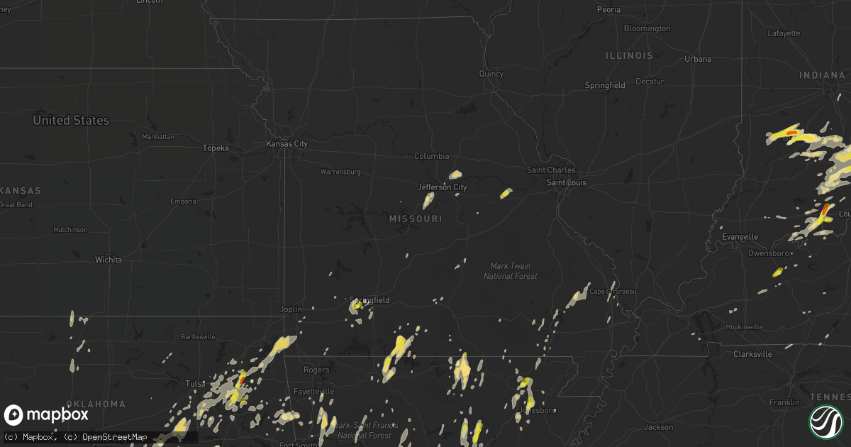
Hail Map in Missouri on May 19, 2017
Get this storm
May 19 map
$229
one time, instant access
Download today. No call, no setup
Keep the $229
Bought the map and want the full workflow? Apply the entire $229 to a subscription within 7 days. None of it is wasted.
Every map, not just this one
This buys you this map. Subscription and you get every map we run, in the markets you choose from a few cities to whole states to nationwide. Plus real-time alerts the moment a storm fires.
Contact data
Name, contact info, occupancy, even credit band for addresses in the footprint. You go from where it hit to who to call.
Become the source they trust
Unlimited branding weather history reports on demand. You already have the documented answer ready for the property owner, and you are the one who showed up with it.
Property data and RoofTrace estimates
Pull up any address you have got, its value and the exact code rules for that jurisdiction, straight from One Click Code. Then RoofTrace estimates the squares, pitch, and roof value, priced the way you price.
Storm reports in Missouri
Missouri
| Date | Description |
|---|---|
| 05/19/20176:44 PM CDT | Large tree uprooted with other large tree limbs down. |
| 05/19/20176:35 PM CDT | Same spotter that called in jefferson city roof damage earlier reports power poles down along industrial drive... Blocking the roadway. |
| 05/19/20176:35 PM CDT | Large trees snapped at base. Power poles damaged. Shingles off roof on the west side of jefferson city. |
| 05/19/20176:34 PM CDT | Large tree limb down with smaller limbs snapped as well. |
| 05/19/20176:30 PM CDT | Jefferson city pd reported trees down and roofs off houses in an area between lohman and wardsville southwest of jefferson city. |
| 05/19/20176:27 PM CDT | Trees bkown over at 2600 block of route cc. Time estiimated by radar. |
| 05/19/20176:00 PM CDT | Several pictures on social media of large tree blown down or damage around the crocker area. |
| 05/19/20175:50 PM CDT | Picture from social media of a tree blown down on to a mobile home and power lines down. Time was estimated. |
| 05/19/20175:50 PM CDT | Large trees down on webb road 1/2 mile from the intersection of county j. Time estimated via radar. |
| 05/19/20175:46 PM CDT | Trees down. |
| 05/19/20175:41 PM CDT | Boat dock damage at the moorings yacht club on lake of the ozarks. Electrical connections from the dock pulled out of the ground. Time estimated via radar. |
| 05/19/20175:15 PM CDT | Several pictures on social media of a tree fell onto a camper near windyville. Time was estimated by radar. |
| 05/19/20174:46 PM CDT | Powerlines down behind the us bank in humansville. |
| 05/19/20174:24 PM CDT | Multiple trees down... Garage damaged. |
| 05/19/20174:24 PM CDT | Quarter to half dollar sized hail per picture posted on social media. |
| 05/19/20174:19 PM CDT | An ef0 tornado occurred along the greene/polk county line wnw of walnut grove on the afternoon of may 19. Damage included several uprooted trees and damage to an outbui |
| 05/19/20174:12 PM CDT | A brief ef-0 rated tornado occurred 2 miles ene of everton. Damage was limited to several trees on either side of e dade rd 152. The path was approximately 1/2 mile lon |
| 05/19/20174:05 PM CDT | A brief ef-0 rated tornado occurred 3 miles southeast of everton in dade county along dade rd 231. Multiple trees were damaged along a path in the area. The path was ap |
| 05/19/20174:00 PM CDT | Several limbs down in everton and lockwood. |
| 05/19/20173:57 PM CDT | An ef-0 rated tornado occurred north-northwest of miller... With estimated peak winds of 85 mph. The tornado had a path length of 1 mi with an approximate width of 100 |
| 05/19/20173:55 PM CDT | Social media picture of bleachers thrown into netting at the miller ballpark. Time estimated from radar. |
| 05/19/20173:49 PM CDT | Report of a barn in the roadway along oo highway 1/4 mile west of 39 highway. |
| 05/19/20173:45 PM CDT | Car blown off of i-44 near 43 mm along i-44. |
| 05/19/20173:44 PM CDT | Multiple buildings damaged near 39.8 mm along i-44 per mercy ems supervisor. |
| 05/19/20173:42 PM CDT | An ef-1 tornado with estimated winds of 95 mph touched down southwest of mount vernon. The tornado was on the ground for about 4 miles and was about 300 yards wide. A c |
| 05/19/20173:42 PM CDT | An ef-1 tornado with estimated winds of 95 mph touched down southwest of mount vernon. The tornado was on the ground for about 4 miles and was about 300 yards wide. A c |
| 05/19/20173:40 PM CDT | Report of a home heavy damaged near exit 33 on i-44. |
| 05/19/20173:35 PM CDT | Estimated 60 mph winds. |
| 05/19/20173:11 PM CDT | A tornado likely occurred on the north side of neosho based on numerous damage reports and photographs. Time estimated from radar. An official storm survey to establish |
| 05/19/20173:11 PM CDT | Trees and powerlines down. |
| 05/19/20173:11 PM CDT | Powerlines down along n. High street. |
| 05/19/20173:11 PM CDT | Multiple reports of trees and powerlines down across the northern portions of neosho. Some structural damage also reported. |
| 05/19/20173:10 PM CDT | An ef-1 tornado touched down along us highway 60 on the northeast side of neosho. The damage path was about 4 miles long and 300 yards wide with estimated winds of 95 m |
| 05/19/20172:55 PM CDT | An ef-1 tornado with estimated winds of 90 mph touched down along the newton-mcdonald county line southeast of seneca. The tornado was about 100 yards wide and stayed o |
| 05/19/20172:55 PM CDT | Damage to trees and buildings along hottel springs rd south of us 60. |
| 05/19/20175:15 AM CDT | House with section of metal roof peeled back. Damage to an outbuilding. A couple of utilty sheds missing chunks of rooftop. Small radio tower twisted and brought down. |
| 05/19/20173:30 AM CDT | Large tree fell on to a truck in alton. Picture and report was from social media. Time was estimated by public report and radar. |
| 05/19/20173:15 AM CDT | Emergency management reported a circus tent blown down in thayer. Additionally... Trees and power lines down on hwy 63 in town. Time estimated by radar. |
| 05/19/20173:12 AM CDT | ***correction for date and time*** ef-0 tornado with winds of 85 mph touched down on the northeast side of thayer. The tornado was about 300 yards wide and three-quarte |
| 05/18/20177:55 PM CDT | Trees were bent over touching the ground along with dime-sized hail. |
| 05/18/20177:10 PM CDT | Quarter size hail reported at a local business near lanton. |
All States Impacted by Hail Map on May 19, 2017
Cities Impacted by Hail Map on May 19, 2017
- Marion, NC
- Pocahontas, AR
- Patrick Springs, VA
- Ozona, TX
- Salem, AR
- Rocky Mount, VA
- Alton, VA
- South Boston, VA
- Quitman, AR
- Greenbrier, AR
- Lancaster, OH
- Sugar Grove, OH
- Logan, OH
- Junction City, OH
- Bremen, OH
- Republic, MO
- Claremore, OK
- Chelsea, OK
- Avoca, TX
- Lueders, TX
- Stamford, TX
- Salem, IN
- Austin, IN
- Scottsburg, IN
- Paris Crossing, IN
- Commiskey, IN
- Crothersville, IN
- Brownstown, IN
- Deputy, IN
- Vallonia, IN
- Naylor, MO
- Neelyville, MO
- Conway, AR
- Campbellsburg, IN
- Hamlin, TX
- Newcastle, TX
- Haskell, TX
- Anson, TX
- Throckmorton, TX
- Sylvester, TX
- San Angelo, TX
- Rocksprings, TX
- Collettsville, NC
- Peabody, KS
- Sperryville, VA
- Floyd, VA
- Scipio, IN
- Seymour, IN
- Campbellsville, KY
- Gustine, TX
- Comanche, TX
- Hot Springs Village, AR
- Cannelton, IN
- Tell City, IN
- Bronte, TX
- Evington, VA
- Lynch Station, VA
- Mead, OK
- Cartwright, OK
- Calera, OK
- Pottsboro, TX
- Kingston, OK
- Heath, OH
- Jacksontown, OH
- Hebron, OH
- Thornville, OH
- Christoval, TX
- Eldorado, TX
- Aspermont, TX
- Hartford, KY
- Utica, KY
- Wirtz, VA
- Terral, OK
- Ryan, OK
- Olney, TX
- Hulbert, OK
- Fort Gibson, OK
- Wagoner, OK
- Hanna, OK
- Dustin, OK
- Corydon, IN
- Protem, MO
- Theodosia, MO
- Rueter, MO
- Ava, MO
- Healdton, OK
- Ringling, OK
- Wilson, OK
- Springer, OK
- Santa Anna, TX
- Coleman, TX
- Gouldbusk, TX
- Campton, KY
- Slade, KY
- Stanton, KY
- Beattyville, KY
- Rogers, KY
- Eden, TX
- Caldwell, KS
- Poolesville, MD
- Beallsville, MD
- Jayton, TX
- Old Glory, TX
- Tahlequah, OK
- Welling, OK
- Henrietta, TX
- Wellington, KY
- Art, TX
- Mason, TX
- Mounds, OK
- Beggs, OK
- Holliday, TX
- Rule, TX
- Seymour, TX
- Wanette, OK
- Burrton, KS
- Moundridge, KS
- Greensboro, NC
- Grandin, MO
- Ellsinore, MO
- Powhatan, VA
- Abilene, KS
- Stephenville, TX
- Bloomington, IN
- Bowling Green, KY
- Burkburnett, TX
- Mitchell, IN
- Orleans, IN
- Bedford, IN
- Roxboro, NC
- Freeland, MD
- Menard, TX
- Hext, TX
- Brady, TX
- Burlington, NC
- Elon, NC
- Locust Grove, OK
- Flippin, AR
- Hamptonville, NC
- Yadkinville, NC
- Boonville, NC
- Davis, OK
- Okmulgee, OK
- Morris, OK
- Depauw, IN
- New Haven, MO
- Leslie, MO
- Washington, MO
- Brownwood, TX
- Franklin, AR
- Temple, OK
- Walters, OK
- Comanche, OK
- Duncan, OK
- Big Spring, TX
- Bristow, OK
- Okemah, OK
- Del Rio, TX
- Rochester, TX
- O'Brien, TX
- Weinert, TX
- Munday, TX
- Evening Shade, AR
- Horseshoe Bend, AR
- Holton, IN
- Versailles, IN
- Wichita Falls, TX
- Huntington, AR
- Chouteau, OK
- Kinsale, VA
- Hurricane, WV
- Sod, WV
- Griffithsville, WV
- Mullin, TX
- Eola, TX
- Wall, TX
- Mereta, TX
- Goodfellow Afb, TX
- Brookesmith, TX
- Rochelle, TX
- Paint Rock, TX
- Bangs, TX
- Vancourt, TX
- Early, TX
- Valera, TX
- Millersview, TX
- Rowena, TX
- Ballinger, TX
- Miles, TX
- Voss, TX
- Fort George G Meade, MD
- Laurel, MD
- Beltsville, MD
- Burtonsville, MD
- Odenton, MD
- Bowie, MD
- Gambrills, MD
- Crofton, MD
- Silver Spring, MD
- Ward, AR
- Cabot, AR
- Beebe, AR
- Lonoke, AR
- Austin, AR
- Ada, OK
- Wellington, KS
- Norton, TX
- Winters, TX
- Talpa, TX
- Walnut Ridge, AR
- Cedar Grove, NC
- Mebane, NC
- Efland, NC
- Glade Hill, VA
- Lead Hill, AR
- Harrison, AR
- Sonora, TX
- McLeansville, NC
- Gibsonville, NC
- Abilene, TX
- Comstock, TX
- Graham, TX
- Spencer, IN
- Worthington, IN
- Freedom, IN
- Coal City, IN
- Florence, KS
- Crittenden, KY
- Dry Ridge, KY
- Bellevue, TX
- Richardsville, VA
- Fredericksburg, VA
- Fort Cobb, OK
- Elmore City, OK
- Pauls Valley, OK
- Spotsylvania, VA
- Shelbyville, KY
- Jonesboro, TX
- Hico, TX
- Hamilton, TX
- Brevard, NC
- Sweetwater, TX
- Roscoe, TX
- Windthorst, TX
- Colorado City, TX
- Loraine, TX
- Merkel, TX
- McCaulley, TX
- Albany, TX
- Westbrook, TX
- Roby, TX
- Altamont, IL
- Doss, TX
- Fredericksburg, TX
- Tobaccoville, NC
- East Bend, NC
- Pfafftown, NC
- Milford, VA
- Barnett, MO
- Versailles, MO
- Bexar, AR
- Sturkie, AR
- Ash Flat, AR
- Violet Hill, AR
- Oxford, AR
- Wiseman, AR
- Glencoe, AR
- Camp, AR
- West Plains, MO
- Stilwell, OK
- Bono, AR
- Jonesboro, AR
- Medford, OK
- Devol, OK
- Randlett, OK
- Sardis, OH
- Battletown, KY
- Payneville, KY
- Brandenburg, KY
- Hennepin, OK
- Ratliff City, OK
- Tussy, OK
- Foster, OK
- Weiner, AR
- Cash, AR
- Carlton, TX
- West Jefferson, OH
- Plain City, OH
- Mechanicsburg, OH
- London, OH
- Irwin, OH
- Nashville, IN
- Gosport, IN
- Solsberry, IN
- Bloomfield, IN
- Ellettsville, IN
- Clay City, IN
- Gladys, VA
- Brookneal, VA
- Lore City, OH
- Salesville, OH
- Senecaville, OH
- Vevay, IN
- Bennington, IN
- Fairfax, OK
- Highland, IL
- Pleasureville, KY
- Lockport, KY
- Central City, KY
- Bremen, KY
- Judsonia, AR
- Kensett, AR
- Searcy, AR
- Palestine, TX
- Iowa Park, TX
- Tishomingo, OK
- Mill Creek, OK
- Stonewall, OK
- Milburn, OK
- Jefferson City, MO
- Russellville, MO
- Olean, MO
- Eldon, MO
- Eugene, MO
- Henley, MO
- San Saba, TX
- Holdenville, OK
- Wewoka, OK
- Greenville, IN
- Pekin, IN
- Borden, IN
- Reidsville, NC
- Hilliard, OH
- Viola, AR
- Garden City, TX
- Bunch, OK
- Denison, TX
- Floral, AR
- Concord, AR
- Owenton, KY
- New Castle, IN
- Muncie, IN
- Selma, IN
- Parker City, IN
- Losantville, IN
- Mooreland, IN
- Siloam, NC
- Colbert, OK
- Grantsburg, IN
- English, IN
- Neosho, MO
- Berea, KY
- Springfield, MO
- De Valls Bluff, AR
- Franklin, VA
- Zuni, VA
- Carrsville, VA
- Billings, MO
- Goldthwaite, TX
- Doole, TX
- Rockwood, TX
- Richland Springs, TX
- Novice, TX
- Mertzon, TX
- Melvin, TX
- Zephyr, TX
- Roosevelt, TX
- Lawn, TX
- Goldsboro, TX
- Junction, TX
- Lohn, TX
- Baird, TX
- Tuscola, TX
- Clyde, TX
- Lometa, TX
- Wingate, TX
- Ovalo, TX
- Hardy, VA
- Moneta, VA
- Phillipsburg, KS
- Glade, KS
- Kirwin, KS
- Stockton, KS
- Agra, KS
- Logan, KS
- Centertown, KY
- Milan, KS
- Wyandotte, OK
- Tiff City, MO
- Anderson, MO
- Grove, OK
- Goodman, MO
- Flat Rock, NC
- Hendersonville, NC
- Sadler, TX
- Gordonville, TX
- Eden, NC
- Cullen, VA
- Charlotte Court House, VA
- Keysville, VA
- Locust Grove, VA
- Huddleston, VA
- Newton, KS
- McKee, KY
- Nashport, OH
- Reeds, MO
- Sarcoxie, MO
- Salyersville, KY
- West Liberty, KY
- Hunter, OK
- Rusk, TX
- Byers, TX
- Boynton, OK
- Heltonville, IN
- Norman, IN
- Natural Dam, AR
- Adolphus, KY
- Westmoreland, TN
- Canal Winchester, OH
- Reynoldsburg, OH
- Pickerington, OH
- Columbus, OH
- Haskell, OK
- Summerfield, NC
- Lancaster, KY
- Stanford, KY
- Elmdale, KS
- Strong City, KS
- Cedar Point, KS
- Lincolnville, KS
- Marion, KS
- Loving, TX
- Springport, IN
- Farmland, IN
- Winchester, IN
- Modoc, IN
- Lone Grove, OK
- Graham, OK
- Nocona, TX
- Ringgold, TX
- Waurika, OK
- Ardmore, OK
- Hawley, TX
- Trent, TX
- Tolar, TX
- Ozark, AR
- Zirconia, NC
- Charleston, AR
- Lavaca, AR
- Vilonia, AR
- El Paso, AR
- Goree, TX
- Chestertown, MD
- Centreville, MD
- New Baden, IL
- Germantown, IL
- Trenton, IL
- Tulsa, OK
- Maysville, OK
- Purcell, OK
- Swifton, AR
- Ramsey, IN
- Elkwood, VA
- Lignum, VA
- Stevensburg, VA
- Culpeper, VA
- Elkton, VA
- Stanardsville, VA
- Peggs, OK
- Seneca, MO
- Salina, OK
- Eucha, OK
- Porter, OK
- Catoosa, OK
- South West City, MO
- Pryor, OK
- Muskogee, OK
- Spavinaw, OK
- Bixby, OK
- Colcord, OK
- Jay, OK
- Broken Arrow, OK
- Coweta, OK
- Inola, OK
- Fredonia, KS
- Poteau, OK
- Cameron, OK
- Chester, AR
- Evant, TX
- Gatesville, TX
- Purmela, TX
- Montross, VA
- Gretna, VA
- Vernon Hill, VA
- Nathalie, VA
- Java, VA
- Iredell, TX
- Pottsville, TX
- Milltown, IN
- Marengo, IN
- Sulphur, OK
- Lenoir, NC
- Blowing Rock, NC
- Cedar Hill, TN
- Byars, OK
- Stratford, OK
- Irvine, KY
- Mayfield, KS
- Reisterstown, MD
- Sparks Glencoe, MD
- Upperco, MD
- Kernersville, NC
- Coalgate, OK
- Copperas Cove, TX
- Clifton, TX
- Cranfills Gap, TX
- Park Hill, OK
- Kremlin, OK
- Pond Creek, OK
- Vian, OK
- Gore, OK
- Batesville, AR
- Bald Knob, AR
- Bradford, AR
- Pleasant Plains, AR
- Oil Trough, AR
- Ravenden Springs, AR
- Walnut Springs, TX
- Meridian, TX
- Browns Summit, NC
- Crestwood, KY
- La Grange, KY
- Smithfield, KY
- Lost Springs, KS
- Herington, KS
- Wakita, OK
- Manchester, OK
- Bluff City, KS
- Canaan, IN
- Arkadelphia, AR
- Burkeville, VA
- Meherrin, VA
- Green Bay, VA
- Newark, OH
- Laurelville, OH
- Circleville, OH
- Prestonsburg, KY
- Calumet, OK
- Sasakwa, OK
- Oakland, AR
- Pontiac, MO
- Wellston, OH
- Jackson, OH
- Wetumka, OK
- Wynnewood, OK
- Glenford, OH
- Harrisonburg, VA
- Farmington, PA
- Cedarcreek, MO
- Bradleyville, MO
- Thornfield, MO
- Peel, AR
- Colfax, NC
- Oak Ridge, NC
- Westville, OK
- Summers, AR
- Mayflower, AR
- Wilburn, AR
- Pangburn, AR
- Ropesville, TX
- Stephensport, KY
- Hardinsburg, KY
- Dover, DE
- Mount Vernon, KY
- Brodhead, KY
- Sedgwick, KS
- Nashville, IL
- Robert Lee, TX
- Leavenworth, IN
- Lexington, IN
- Locust Grove, AR
- Sandy Level, VA
- Pinckneyville, IL
- Kingman, KS
- Ashland City, TN
- Chapmansboro, TN
- Center Ridge, AR
- Solgohachia, AR
- Hattieville, AR
- Hardinsburg, IN
- Hartford, AR
- Indianola, OK
- Mcalester, OK
- Mountainburg, AR
- Castell, TX
- London, TX
- Dublin, TX
- Pottersville, MO
- Buhler, KS
- Wasola, MO
- Squires, MO
- Yellville, AR
- Noble, MO
- Waukomis, OK
- Enid, OK
- Canehill, AR
- Little Rock, AR
- England, AR
- Sterling City, TX
- Tunica, MS
- Konawa, OK
- Couch, MO
- Mokane, MO
- Tebbetts, MO
- Fulton, MO
- New Bloomfield, MO
- Port Royal, VA
- Warsaw, VA
- Round Mountain, TX
- Walnut Cove, NC
- Walkertown, NC
- New Salem, PA
- Uniontown, PA
- McClellandtown, PA
- Phenix, VA
- Mount Solon, VA
- Churchville, VA
- Vinton, VA
- Bedford, VA
- Thaxton, VA
- Coila, MS
- Wilsons, VA
- Crewe, VA
- Blackstone, VA
- Lindsay, OK
- Ozark, MO
- Burkesville, KY
- Columbia, KY
- Breeding, KY
- Petrolia, TX
- Jerusalem, AR
- Glenallen, MO
- Marble Hill, MO
- Winston Salem, NC
- Bigelow, AR
- Broadway, VA
- Linville, VA
- Rosie, AR
- Biscoe, AR
- Durant, OK
- Glade Valley, NC
- Atlanta, KS
- Oxford, NC
- Kingfisher, OK
- Pataskala, OH
- Greenfield, MO
- Arcola, MO
- Sweeden, KY
- Bee Spring, KY
- Mammoth Cave, KY
- Stuart, VA
- Critz, VA
- Brookline, MO
- Jacksonville, AR
- Rappahannock Academy, VA
- Wolfforth, TX
- Winfield, KS
- Earlsboro, OK
- Harviell, MO
- Kenefic, OK
- Houston, AR
- Tupelo, OK
- Morrilton, AR
- Lexington, OK
- Noble, OK
- Electra, TX
- Madison, IN
- Florence, IN
- Cross Plains, IN
- Cape Girardeau, MO
- Clever, MO
- Bois D Arc, MO
- Marshall, NC
- Stuttgart, AR
- West Fork, AR
- Evansville, AR
- Prairie Grove, AR
- Rotan, TX
- Alicia, AR
- Hoxie, AR
- Gracemont, OK
- Tiger, GA
- Mountain Grove, MO
- Chaffee, MO
- Scott City, MO
- Zalma, MO
- Elkins, AR
- Huntsville, AR
- Ruther Glen, VA
- Fordsville, KY
- Hurt, VA
- Kensington, KS
- Bogue, KS
- Melbourne, AR
- Rockville, MD
- Springville, IN
- Frazeysburg, OH
- Hebron, NE
- Deshler, NE
- Wynona, OK
- Rome, IN
- Derby, IN
- Roff, OK
- Winslow, AR
- Shawnee, OK
- Hugo, OK
- Fayetteville, AR
- Virgilina, VA
- Halifax, VA
- Mount Vernon, AR
- Enola, AR
- Rice, VA
- New Castle, KY
- Eminence, KY
- Columbus, IN
- North Vernon, IN
- Elizabethtown, IN
- Paint Lick, KY
- Sapulpa, OK
- Advance, NC
- Fisher, AR
- Fairdealing, MO
- Doniphan, MO
- Lower Salem, OH
- Graysville, OH
- Rising Sun, IN
- Williamstown, KY
- Glencoe, KY
- Mount Judea, AR
- Hague, VA
- Colonial Beach, VA
- Covington, TN
- Mason, TN
- Guston, KY
- Mannsville, OK
- Wapello, IA
- Columbus Junction, IA
- Hardy, AR
- Cherokee Village, AR
- Bland, MO
- Whitesboro, TX
- Collinsville, TX
- Jonesville, NC
- De Mossville, KY
- Warsaw, KY
- Harrold, TX
- Galax, VA
- Oakfield, TN
- Jackson, TN
- King George, VA
- Rush Springs, OK
- Marlow, OK
- Edgemont, AR
- Higden, AR
- Woodson, TX
- Alma, AR
- Kinta, OK
- Quaker City, OH
- Perryville, AR
- Fawn Grove, PA
- New Park, PA
- Airville, PA
- Felton, PA
- Sparta, KY
- Drury, MO
- Heber Springs, AR
- Drasco, AR
- Seligman, MO
- Long Island, VA
- Owensburg, IN
- New Harmony, IN
- Wadesville, IN
- Lowgap, NC
- Mount Airy, NC
- Cana, VA
- Sanders, KY
- Falmouth, KY
- Morning View, KY
- Verona, KY
- Walton, KY
- Highlands, NC
- Meeker, OK
- Miller, MO
- Isabella, MO
- Wake Forest, NC
- Brockwell, AR
- Koshkonong, MO
- Beach Haven, NJ
- Barnegat Light, NJ
- Grandfield, OK
- New Salisbury, IN
- Lebanon, MO
- Centerville, TX
- Davidson, OK
- Vinton, OH
- Partridge, KS
- Pretty Prairie, KS
- Arlington, KS
- Hutchinson, KS
- Nixa, MO
- Salem, IL
- Centrahoma, OK
- Turners Station, KY
- State Road, NC
- Elkin, NC
- Fitzhugh, OK
- Dougherty, OK
- Madill, OK
- Atoka, OK
- Fittstown, OK
- Wapanucka, OK
- Coleman, OK
- Hawesville, KY
- Branchville, IN
- Union Star, KY
- Palmyra, IN
- Leopold, IN
- Pinnacle, NC
- Scotland, TX
- Seminole, OK
- Paden, OK
- Pomona, IL
- Murphysboro, IL
- Alto Pass, IL
- Nineveh, IN
- Crab Orchard, KY
- Eufaula, OK
- Tye, TX
- Dyess Afb, TX
- Knotts Island, NC
- Old Fort, NC
- Blue Ridge, VA
- Vinita, OK
- Strang, OK
- Mount Perry, OH
- Jackson, KY
- Germantown, MD
- Boyds, MD
- Dickerson, MD
- Olney, MD
- Lampasas, TX
- Paragould, AR
- Goodview, VA
- Derwood, MD
- Washington Grove, MD
- Gaithersburg, MD
- Paoli, IN
- Fredericksburg, IN
- Linton, IN
- Jasonville, IN
- Freetown, IN
- Dupont, IN
- Medora, IN
- Switz City, IN
- Jonesville, IN
- Beaver Dam, KY
- McHenry, KY
- Mulberry, AR
- Washburn, MO
- Allen, OK
- Harned, KY
- Scotland, AR
- Edgar Springs, MO
- Paoli, OK
- Smith Center, KS
- Forest, VA
- Goode, VA
- Stigler, OK
- Butlerville, IN
- Staffordsville, KY
- Hagerhill, KY
- Norman, OK
- Tecumseh, OK
- Macomb, OK
- Clinton, AR
- Leslie, AR
- Thida, AR
- Poplar Bluff, MO
- Knox City, TX
- Scottsville, KY
- Underwood, IN
- McClure, IL
- Alum Creek, WV
- Milton, WV
- Hamlin, WV
- Culloden, WV
- Sumerco, WV
- Tornado, WV
- West Hamlin, WV
- Coldwater, MS
- Hernando, MS
- Stem, NC
- Rougemont, NC
- Sikeston, MO
- Hillsborough, NC
- Sheppard Afb, TX
- Singers Glen, VA
- Fulks Run, VA
- Atwood, OK
- Lamar, OK
- Calvin, OK
- Griffithville, AR
- Gipsy, MO
- Lowndes, MO
- Leopold, MO
- Yorktown, VA
- Dale, IN
- Saint Meinrad, IN
- Ferdinand, IN
- Huntingburg, IN
- Altavista, VA
- Williamsville, MO
- Greenville, MO
- Pilot Point, TX
- Tioga, TX
- Beaufort, MO
- Gerald, MO
- Ghent, KY
- Lavinia, TN
- Medina, TN
- Milan, TN
- Sherman, TX
- Bradford, OH
- Delaplaine, AR
- O'Kean, AR
- Beech Grove, AR
- Biggers, AR
- Fort Eustis, VA
- Newport News, VA
- Romance, AR
- Deer, AR
- Hackett, AR
- Greenwood, AR
- Sarah, MS
- Kellyville, OK
- Wichita, KS
- Haysville, KS
- Oil Springs, KY
- Hampton, VA
- Atkins, AR
- Moravian Falls, NC
- Woodford, VA
- Spencer, VA
- Meadows Of Dan, VA
- Madison, NC
- Rock Hall, MD
- Somerset, OH
- Granville, OH
- Philo, OH
- Roseville, OH
- Zanesville, OH
- Crooksville, OH
- Buckeye Lake, OH
- Blue Rock, OH
- Castle, OK
- Boley, OK
- Weleetka, OK
- Prague, OK
- Afton, OK
- King, NC
- Reynolds Station, KY
- Granby, MO
- Diamond, MO
- Hominy, OK
- Oolitic, IN
- Leon, KS
- Latham, KS
- Marcella, AR
- Harper, TX
- Nash, OK
- Omaha, AR
- Crane, MO
- Marionville, MO
- Mize, KY
- Hazel Green, KY
- Cannel City, KY
- Laconia, IN
- Rhodelia, KY
- Mauckport, IN
- New Matamoras, OH
- Crownsville, MD
- Okarche, OK
- Saint Paris, OH
- Witts Springs, AR
- Obion, TN
- Clarksville, AR
- Ozone, AR
- Rose, OK
- Valley View, TX
- Springfield, TN
- Bethesda, MD
- North Little Rock, AR
- Hensley, AR
- Scott, AR
- Argonia, KS
- Stuart, OK
- Cecil, AR
- Burkett, TX
- Lohman, MO
- Lawton, OK
- White Hall, MD
- Parkton, MD
- Stewartstown, PA
- Poquoson, VA
- Mammoth Spring, AR
- Maud, OK
- Cleveland, AR
- Hastings, OK
- Archer City, TX
- Jacksboro, TX
- Kiefer, OK
- Success, AR
- Corning, AR
- Dexter, KY
- Murray, KY
- Adair, OK
- Haven, KS
- Chester, IL
- Steeleville, IL
- Belzoni, MS
- Tchula, MS
- Dawson Springs, KY
- Crofton, KY
- Licking, MO
- Beulah, MO
- Hagarville, AR
- Plains, KS
- Sharpsburg, KY
- Owingsville, KY
- Ash Grove, MO
- Jacobsburg, OH
- Belmont, OH
- Greenwood, IN
- Indianapolis, IN
- Plumerville, AR
- Peck, KS
- Oktaha, OK
- Council Hill, OK
- Wideman, AR
- Germanton, NC
- Greenwood, MS
- Carrollton, MS
- Higginson, AR
- Madison, VA
- Cobden, IL
- Jonesboro, IL
- Makanda, IL
- Blanket, TX
- Bokchito, OK
- Trafalgar, IN
- Morgantown, IN
- Spiro, OK
- Bokoshe, OK
- Quinton, OK
- Holts Summit, MO
- Mountain Home, TX
- Severna Park, MD
- Clearwater, KS
- Princeton, KY
- Cerulean, KY
- Junction City, KY
- Dillsboro, IN
- Danville, KY
- Loco, OK
- Sallisaw, OK
- New Martinsville, WV
- Winona, MO
- Tennyson, IN
- McRae, AR
- Hector, AR
- Ararat, VA
- Hillsville, VA
- Lambsburg, VA
- Fancy Gap, VA
- Almyra, AR
- Asher, OK
- Saint Clairsville, OH
- Cunningham, TN
- Suffolk, VA
- Brookland, AR
- Linn, MO
- Loose Creek, MO
- Vancleve, KY
- Zoe, KY
- Ravenna, KY
- Hardin, KY
- Benton, KY
- Dunnville, KY
- Cushing, OK
- Church Hill, MD
- Wappapello, MO
- Muldrow, OK
- Partlow, VA
- Halstead, KS
- Black Oak, AR
- Lake City, AR
- Burden, KS
- Birdseye, IN
- Eckerty, IN
- Felton, DE
- Aurora, MO
- Livermore, KY
- Whitesville, KY
- Carlsbad, TX
- Lubbock, TX
- Sandy Spring, MD
- Ashton, MD
- Spencerville, MD


