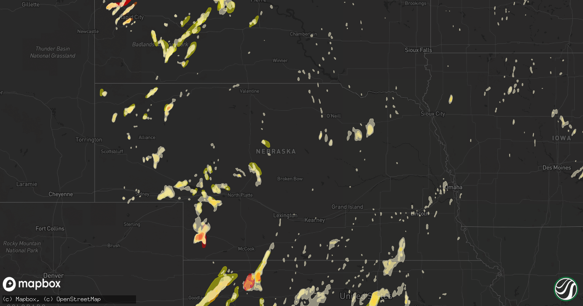
Hail Map in Nebraska on May 18, 2013
Get this storm
May 18 map
$229
one time, instant access
Download today. No call, no setup
Keep the $229
Bought the map and want the full workflow? Apply the entire $229 to a subscription within 7 days. None of it is wasted.
Every map, not just this one
This buys you this map. Subscription and you get every map we run, in the markets you choose from a few cities to whole states to nationwide. Plus real-time alerts the moment a storm fires.
Contact data
Name, contact info, occupancy, even credit band for addresses in the footprint. You go from where it hit to who to call.
Become the source they trust
Unlimited branding weather history reports on demand. You already have the documented answer ready for the property owner, and you are the one who showed up with it.
Property data and RoofTrace estimates
Pull up any address you have got, its value and the exact code rules for that jurisdiction, straight from One Click Code. Then RoofTrace estimates the squares, pitch, and roof value, priced the way you price.
Storm reports in Nebraska
Nebraska
| Date | Description |
|---|---|
| 05/18/20136:50 PM CDT | Stones ranged in size from dimes to quarters. Time is estimated by radar. |
| 05/18/20136:50 PM CDT | A local report indicates 2.50 inch wind near 7 S IMPERIAL |
| 05/18/20136:40 PM CDT | A local report indicates 1.75 inch wind near 10 S RUSHVILLE |
| 05/18/20136:30 PM CDT | Stones ranged in size from peas to quarters. |
| 05/18/20136:20 PM CDT | A local report indicates 1.00 inch wind near SIDNEY |
| 05/18/20136:15 PM CDT | A local report indicates 1.00 inch wind near 13 N HAY SPRINGS |
| 05/18/20136:10 PM CDT | Penny to quarter sized hail in sidney. Numerous reports. |
| 05/18/20136:01 PM CDT | A local report indicates a tornado near 9 N BROADWATER |
| 05/18/20135:58 PM CDT | A local report indicates a tornado near 10 N BROADWATER |
| 05/18/20135:34 PM CDT | A local report indicates 1.00 inch wind near 12 NW SIDNEY |
| 05/18/20135:32 PM CDT | Several reports of quarter sized hail in brownson. Relayed via sidney warning point. |
| 05/18/20135:15 PM CDT | Stones ranged everywhere from pea to quarter size. |
| 05/18/20135:15 PM CDT | Report relayed through social media. Time and location estimated based on radar. |
| 05/18/20135:08 PM CDT | Nickel to quarter sized hail. Hail has ended. |
| 05/18/20134:55 PM CDT | A local report indicates 1.00 inch wind near 7 NNE BRULE |
| 05/18/20134:35 PM CDT | Most stones were pea to dime size and were covering the ground. There were a few quarter sized stones. |
| 05/18/201312:00 AM CDT | Tree and swing set damage...delayed report from last night. |
| 05/17/201311:44 PM CDT | Six inch tree limbs downed and nickel-sized hail. 1.65 inches of rain measured. |
| 05/17/201311:40 PM CDT | Roof taken off of a shed along hwy 77. |
| 05/17/201311:33 PM CDT | A local report indicates 1.00 inch wind near JANSEN |
| 05/17/201311:31 PM CDT | A local report indicates 1.00 inch wind near FAIRBURY |
| 05/17/201310:31 PM CDT | Spotty tree damage reported along with some power outages. |
| 05/17/20138:59 PM CDT | Small branches have also been broken. |
| 05/17/20138:35 PM CDT | A local report indicates 1.00 inch wind near 3 E IMPERIAL |
| 05/17/20138:34 PM CDT | Tree is down across game trail road north of hwy 30. |
| 05/17/20138:15 PM CDT | Mostly nickel size hail...but some quarter size. |
| 05/17/20138:15 PM CDT | Quarter size hail reported along with winds estimated at 60mph. |
| 05/17/20137:57 PM CDT | A local report indicates 1.00 inch wind near 2 S KEYSTONE |
| 05/17/20137:49 PM CDT | Power lines were knocked down at county roads 185 and 28. Time is estimated. |
| 05/17/20137:45 PM CDT | Possible tornado damage with report of trees laying on houses and a garage being blown up over 15 to 20 ft trees landing on a neighbors property. |
| 05/17/20137:42 PM CDT | A local report indicates 61 MPH wind near 2 NE NORMAN |
| 05/17/20137:41 PM CDT | Quarter size hail reported 8 miles north and 1 mile west of grant. |
| 05/17/20137:35 PM CDT | Dawson county emergency services. Exact time unkn but estimated from awos. |
| 05/17/20137:29 PM CDT | Quarter size hail reported 3 miles north east of grant. |
| 05/17/20137:17 PM CDT | Hailed for five minutes. |
| 05/17/20137:11 PM CDT | Trees down at the intersection of co rd 207 and hwy 22. |
| 05/17/20137:06 PM CDT | Gust measured on observers davis unit |
| 05/17/20137:04 PM CDT | Public report of 1.5 inch hail |
| 05/17/20137:00 PM CDT | Stones ranged from peas to half dollar size. Pea size hail is still falling. |
All States Impacted by Hail Map on May 18, 2013
Cities Impacted by Hail Map on May 18, 2013
- Ogema, MN
- Garner, IA
- Lewellen, NE
- White Lake, SD
- Hay Springs, NE
- Rapid City, SD
- Keswick, IA
- Barnes City, IA
- What Cheer, IA
- Gibson, IA
- Deep River, IA
- The Villages, FL
- Summerfield, FL
- Belleview, FL
- Oxford, FL
- Boys Town, NE
- Omaha, NE
- Bennington, NE
- Bethune, CO
- Burlington, CO
- Sharon, OK
- Osborne, KS
- Booker, TX
- Quanah, TX
- Crowell, TX
- Plainville, KS
- Eagle Butte, SD
- Dupree, SD
- Fort Pierre, SD
- Vinson, OK
- Hollis, OK
- Gould, OK
- Kadoka, SD
- Sayre, OK
- Elk City, OK
- Faith, SD
- Faxon, OK
- Wildwood, FL
- Upton, WY
- Danube, MN
- Waukomis, OK
- Hennessey, OK
- Rolfe, IA
- Long Island, KS
- Phillipsburg, KS
- Atkinson, NE
- Colby, KS
- Gem, KS
- Hemingford, NE
- Greenleaf, KS
- Selden, KS
- Geronimo, OK
- Lawton, OK
- Crawford, NE
- Harrison, NE
- Marsland, NE
- Newell, SD
- Vale, SD
- Sturgis, SD
- Bishopville, SC
- Ogallah, KS
- Wakeeney, KS
- Ellis, KS
- Dickinson, ND
- Clara City, MN
- Nashua, IA
- Rushville, NE
- Cleveland, ND
- Medina, ND
- Jamestown, ND
- Webster, IA
- Delta, IA
- Sigourney, IA
- Neligh, NE
- Tilden, NE
- Plainview, NE
- Lorraine, KS
- Philip, SD
- Morland, KS
- Collyer, KS
- Hill City, KS
- Omega, OK
- Kingfisher, OK
- Ransom, KS
- Utica, KS
- Clearwater, NE
- Altus, OK
- Clay Center, KS
- Munday, TX
- Weinert, TX
- Goree, TX
- Sedan, KS
- Bridgeport, NE
- Brule, NE
- Chappell, NE
- Oshkosh, NE
- Big Springs, NE
- Ogallala, NE
- Mangum, OK
- Duke, OK
- Childress, TX
- Raleigh, ND
- Shields, ND
- Carson, ND
- Marshall, OK
- Bison, OK
- Douglas, OK
- Guernsey, IA
- Victor, IA
- Dighton, KS
- Quinter, KS
- Enid, OK
- Broadwater, NE
- Edgerton, KS
- Kyle, SD
- Scenic, SD
- Alliance, NE
- Paxton, NE
- Elk City, KS
- Hays, KS
- Kinsley, KS
- Larned, KS
- Spearville, KS
- Rozel, KS
- Hanston, KS
- Burdett, KS
- Elgin, ND
- Buffalo, OK
- Deadwood, SD
- Nemo, SD
- Beloit, KS
- Glasco, KS
- Simpson, KS
- Chandler, MN
- Arapaho, OK
- Chillicothe, TX
- Ponsford, MN
- Cyril, OK
- Mountain View, OK
- Fletcher, OK
- Gotebo, OK
- Mountain Park, OK
- Elgin, OK
- Headrick, OK
- Carnegie, OK
- Hobart, OK
- Altus Afb, OK
- Apache, OK
- Indiahoma, OK
- Roosevelt, OK
- Blair, OK
- Lone Wolf, OK
- Gettysburg, SD
- Amelia, NE
- Barnard, KS
- Lincoln, KS
- Grant, NE
- Fairbury, NE
- Endicott, NE
- Elsmere, NE
- Chambers, NE
- Dix, NE
- Interior, SD
- Wall, SD
- Lincoln, NE
- Dacula, GA
- Buford, GA
- Lawrenceville, GA
- Cumming, GA
- Suwanee, GA
- Flowery Branch, GA
- Stuart, NE
- Platte, SD
- Cordell, OK
- Delphos, KS
- Putnam, OK
- Custer City, OK
- Taloga, OK
- Waldo, KS
- Lusk, WY
- Belle Fourche, SD
- Spearfish, SD
- Dill City, OK
- Sentinel, OK
- Republican City, NE
- Naponee, NE
- Covington, OK
- Drummond, OK
- Fairmont, OK
- Brooklyn, IA
- Montezuma, IA
- Jay Em, WY
- Milford, NE
- Dorchester, NE
- Gillette, WY
- Carthage, TN
- Elmwood, TN
- Corn, OK
- Woonsocket, SD
- Welch, OK
- Fairview, OK
- Macksville, KS
- St John, KS
- Atwood, KS
- New Ulm, MN
- Brownell, KS
- Chester, OK
- Seiling, OK
- Minco, OK
- Akron, CO
- Otis, CO
- Lindon, CO
- Oberlin, KS
- Elsie, NE
- Cherry Creek, SD
- Union City, OK
- Tuttle, ND
- Steele, ND
- Linton, ND
- Upland, NE
- Franklin, NE
- Hildreth, NE
- Wilmore, KS
- Coldwater, KS
- Eldorado, OK
- Tryon, NE
- Park, KS
- Cleveland, MO
- Bucyrus, KS
- Belton, MO
- Louisburg, KS
- Beverly, KS
- Concordia, KS
- Clyde, KS
- Aurora, KS
- Minneapolis, KS
- Tescott, KS
- Miltonvale, KS
- Gayville, SD
- Mission Hill, SD
- Pawhuska, OK
- Tuttle, OK
- Mustang, OK
- Newton, IA
- Sioux Rapids, IA
- Linn Grove, IA
- Pine Ridge, SD
- Mutual, OK
- Vici, OK
- Leedey, OK
- Mooreland, OK
- Camargo, OK
- Lisco, NE
- New Leipzig, ND
- Havelock, IA
- Mallard, IA
- Lebanon, TN
- Wilsonville, NE
- Edson, KS
- Levant, KS
- Brewster, KS
- Sharon Springs, KS
- Weskan, KS
- Arapahoe, CO
- Goodland, KS
- McDonald, KS
- Bancroft, IA
- Burt, IA
- Watertown, TN
- Kirksville, MO
- Iona, MN
- Georgiana, AL
- Hayes, SD
- Midland, SD
- Keota, IA
- Wellman, IA
- La Grange, NC
- Seven Springs, NC
- Mound City, SD
- Wakpala, SD
- Glencross, SD
- Timber Lake, SD
- Mobridge, SD
- Trail City, SD
- Imperial, NE
- Piedmont, SD
- Burr Oak, KS
- Esbon, KS
- Mellette, SD
- Inland, NE
- Ralston, OK
- Pawnee, OK
- Holyrood, KS
- Bushton, KS
- Claflin, KS
- Copan, OK
- Murdock, MN
- Sacred Heart, MN
- Raymond, MN
- Maynard, MN
- Protection, KS
- Bayard, NE
- Munden, KS
- Haddam, KS
- Belleville, KS
- Morrowville, KS
- Cuba, KS
- Narka, KS
- Mahaska, KS
- Willow, OK
- Guyton, GA
- Granite, OK
- Turon, KS
- Pratt, KS
- Gordon, NE
- Ninnekah, OK
- Emmetsburg, IA
- West Bend, IA
- Monroe, IA
- Otley, IA
- Reasnor, IA
- Pella, IA
- Wilber, NE
- Pleasant Hill, MO
- Lemoyne, NE
- Artesian, SD
- Clark, SD
- Blairsburg, IA
- Burbank, OK
- Shidler, OK
- Isabella, OK
- Norcatur, KS
- South English, IA
- Harper, IA
- Allen, SD
- Hampton, FL
- Gainesville, FL
- Brooker, FL
- Yuma, CO
- Harrison, SD
- Corsica, SD
- York, NE
- Beaver Crossing, NE
- Pierce, NE
- Fosston, MN
- Seminole, OK
- New London, IA
- Mount Pleasant, IA
- Merriman, NE
- Oswego, KS
- Columbus, KS
- Fairfax, OK
- Stapleton, NE
- New Raymer, CO
- Robinson, ND
- Gove, KS
- Herreid, SD
- Lead, SD
- Medicine Park, OK
- Hubbard, IA
- Champion, NE
- Meno, OK
- Black Hawk, SD
- Porcupine, SD
- Woodward, OK
- George, IA
- Ogden, IA
- Boxholm, IA
- Ashland, NE
- Alexander City, AL
- Marengo, IA
- Ladora, IA
- Williamsburg, IA
- Correll, MN
- Wakefield, KS
- Green, KS
- Meeker, OK
- Alton, KS
- Arthur, NE
- Kaycee, WY
- Clemons, IA
- Zearing, IA
- New Providence, IA
- Saint Anthony, IA
- Hitchcock, SD
- Faulkton, SD
- Seward, NE
- Fredonia, KS
- Longton, KS
- Seibert, CO
- Clinton, OK
- Weatherford, OK
- Rosston, OK
- Gate, OK
- Hettinger, ND
- Stockton, KS
- Woodston, KS
- Lebanon, KS
- Cylinder, IA
- Assaria, KS
- Isabel, SD
- Holstein, NE
- Bladen, NE
- Riverton, NE
- Campbell, NE
- Ness City, KS
- Norton, KS
- Washington, KS
- Blue Springs, MO
- Buckner, MO
- Independence, MO
- Grinnell, IA
- Gilman, IA
- Franklin, KY
- Tuskegee, AL
- Okeene, OK
- Burke, SD
- Hermitage, TN
- Nashville, TN
- Mount Juliet, TN
- Ekalaka, MT
- Fort Cobb, OK
- Scammon, KS
- McCune, KS
- West Mineral, KS
- Ringwood, OK
- Ames, OK
- Saint James, MN
- Darfur, MN
- Brunswick, NE
- Morrison, OK
- Red Rock, OK
- Perry, OK
- Courtland, KS
- Alexandria, NE
- McLaughlin, SD
- Adolphus, KY
- Scottsville, KY
- Westmoreland, TN
- Portland, TN
- Victoria, KS
- Catharine, KS
- Bloomingdale, GA
- Ellabell, GA
- Pierre, SD
- Strong City, KS
- Jennings, KS
- Wood Lake, NE
- Anadarko, OK
- Pocasset, OK
- El Reno, OK
- Paradise, KS
- Gorham, KS
- Natoma, KS
- Madison, MN
- Logan, KS
- Naper, NE
- Vivian, SD
- Garrison, IA
- Dysart, IA
- Le Center, MN
- Le Sueur, MN
- Ruthton, MN
- Walters, OK
- Pettibone, ND
- Woodworth, ND
- Tappen, ND
- Dawson, ND
- Presho, SD
- Throckmorton, TX
- Seymour, TX
- Webster City, IA
- Dows, IA
- Williams, IA
- Sylvania, GA
- Mount Union, IA
- Hayesville, IA
- Elmer, OK
- Tipton, OK
- Snyder, OK
- Draper, SD
- Ellsworth, IA
- Wolsey, SD
- Plymouth, NE
- Western, NE
- Jansen, NE
- Swanton, NE
- Marquette, KS
- Yukon, OK
- Marland, OK
- Springfield, GA
- Wallace, NE
- Wanblee, SD
- Ashland, KS
- Selma, AL
- Sterling, CO
- Merino, CO
- Driscoll, ND
- Wellsville, KS
- Rantoul, KS
- Paola, KS
- Solen, ND
- Vinton, IA
- Mount Auburn, IA
- Liscomb, IA
- Elkhorn, NE
- Dawson, MN
- Raymond, SD
- Odell, TX
- Vernon, TX
- Purdum, NE
- Springfield, TN
- Adams, TN
- Cedar Hill, TN
- Hitchcock, OK
- Garden City, SD
- Walcott, ND
- Keystone, NE
- Chaska, MN
- Wood, SD
- Balko, OK
- Laverne, OK
- Beaver, OK
- Gaylord, KS
- Portis, KS
- Inavale, NE
- Sidney, NE
- Arnold, NE
- Tuskegee Institute, AL
- Chickasha, OK
- Verden, OK
- Hoisington, KS
- Otis, KS
- Bagley, MN
- Waverly, NE
- Benkelman, NE
- Hill City, SD
- Junction City, KS
- Chapman, KS
- Danville, IA
- Middletown, IA
- Friend, NE
- Cordova, NE
- Noble, OK
- Norman, OK
- Vona, CO
- Stratton, CO
- Blanchard, OK
- Cedar Rapids, NE
- Foss, OK
- Butler, OK
- Paducah, TX
- Mankato, KS
- Lame Deer, MT
- Howard, SD
- Flagler, CO
- Iliff, CO
- Radcliffe, IA
- Crofton, NE
- Duncan, OK
- Plover, IA
- Riley, KS
- Nicollet, MN
- Letcher, SD
- Ithaca, NE
- Greenwood, NE
- Kellogg, IA
- Chadron, NE
- Sutherland, NE
- Glen Elder, KS
- Mountain Lake, MN
- Watonga, OK
- Dresden, KS
- Hollenberg, KS
- Reynolds, NE
- Hubbell, NE
- Daykin, NE
- De Witt, NE
- Agenda, KS
- Orchard, IA
- Stamford, NE
- Butterfield, MN
- Sleepy Eye, MN
- Hershey, NE
- Independence, KS
- Keystone, IA
- Van Horne, IA
- Kilgore, NE
- Enders, NE
- Keystone, SD
- Sylvan Grove, KS
- Butte, NE
- Astor, FL
- Fort McCoy, FL
- Kit Carson, CO
- Hermosa, SD
- Okaton, SD
- Flomot, TX
- Matador, TX
- Springfield, SD
- Watertown, SD
- Maud, OK
- Parks, NE
- Oakdale, NE
- Scandia, KS
- Burwell, NE
- Hedley, TX
- Gretna, NE
- Pleasantville, IA
- Swan, IA
- Knoxville, IA
- Sully, IA
- Hoxie, KS
- Alden, IA
- Binger, OK
- Leonardville, KS
- Frankfort, SD
- Wilson, KS
- Walton, NE
- Doland, SD
- Ottumwa, IA
- Peetz, CO
- Padroni, CO
- Hartington, NE
- Fordyce, NE
- Saint Helena, NE
- Wanette, OK
- Coon Rapids, IA
- Bradshaw, NE
- Belpre, KS
- Cologne, MN
- Alma, NE
- Stilwell, KS
- Spring Hill, KS
- Grayson, GA
- Loganville, GA
- Snellville, GA
- Ashton, SD
- Redfield, SD
- Oxford, MS
- Cope, CO
- Albion, NE
- Carpenter, SD
- Hudson, KS
- Lafayette, MN
- Winthrop, MN
- Chestnut Mound, TN
- Wever, IA
- Buchanan, ND
- Streeter, ND
- Litchfield, NE
- Webster, FL
- Center Hill, FL
- Halstead, KS
- Ellsworth, KS
- Republic, KS
- Hardy, NE
- Marysville, KS
- Olivia, MN
- Mullen, NE
- Alexandria, TN
- Huron, SD
- Superior, NE
- McIntosh, SD
- Spring Hill, TN
- Rocky, OK
- Claremore, OK
- Brush Creek, TN
- Gordonsville, TN
- Coffeyville, KS
- Lebanon, NE
- Wetumpka, AL
- Coats, KS
- Kimball, SD
- Bowling Green, KY
- Hector, MN
- Edna, KS
- S Coffeyville, OK
- Peculiar, MO
- Greenwood, MO
- Winger, MN
- Arnold, KS
- Palco, KS
- Chokio, MN
- Clermont, FL
- Groveland, FL
- Palmer, KS
- Morganville, KS
- Clifton, KS
- Gregory, SD
- Holdrege, NE
- Malcolm, NE
- Raymond, NE
- Lakota, IA
- Johnstown, NE
- Onaga, KS
- Olmitz, KS
- Callahan, FL
- Remsen, IA
- Le Mars, IA
- Manning, ND
- Thompson, IA
- Lake Crystal, MN
- Macomb, OK
- Lexington, OK
- Ayr, NE
- Rockwell City, IA
- Lakeside, NE
- Herrick, SD
- Wagner, SD
- Webber, KS
- Wamego, KS
- Blue Hill, NE
- Milford, KS
- Tallassee, AL
- Stroud, OK
- Cushing, OK
- Lawrence, NE
- Pukwana, SD
- Jewell, KS
- Petersburg, NE
- Newcastle, WY
- Waterloo, NE
- Crook, CO
- Port Orange, FL
- Wallace, SD
- Bison, KS
- Rush Center, KS
- Shawnee, OK
- Eustis, FL
- Lake Andes, SD
- Geddes, SD
- Liberty, KS
- Pleasant Dale, NE
- Princeton, MO
- Mounds, OK
- Gibbon, MN
- Haskell, OK
- Okmulgee, OK
- Laurens, IA
- Selfridge, ND
- Appleton, MN
- Choctaw, OK
- Albert City, IA
- Fonda, IA
- Auburn, NE
- Hebron, NE
- Barrett, MN
- Morris, MN
- Kensington, MN
- Hoffman, MN
- Gracemont, OK
- Livermore, IA
- Cement, OK
- Donnellson, IA
- Sac City, IA
- Newell, IA
- Dunning, NE
- Vienna, SD
- Willow Lake, SD
- Marion, KS
- Alberta, MN
- Courtland, MN
- Freedom, OK
- Henderson, NE
- Grafton, NE
- Kingsley, IA
- Leigh, NE
- Stewart, MN
- Quinn, SD
- Plattsmouth, NE
- Gardner, KS
- McKenzie, AL
- Hortense, GA
- Springfield, MN
- Comfrey, MN
- Charter Oak, IA
- Madrid, NE
- Hedrick, IA
- Minneola, KS
- Cheyenne Wells, CO
- Randolph, NE
- Martin, SD
- Cherokee, OK
- Carmen, OK
- Otter, MT
- Bristow, OK
- Glenham, SD
- Cleo Springs, OK
- Braymer, MO
- Hamilton, MO
- Miami, OK
- Bogue, KS
- Ashland, MT
- Crookston, NE
- Pacific Junction, IA
- Glenwood, IA
- Council Bluffs, IA
- Gackle, ND
- Dearing, KS
- Cedar Vale, KS
- Martinsburg, IA
- Gallatin, TN
- Hendersonville, TN
- Mannford, OK
- Winfield, IA
- Anton, CO
- Waldo, FL
- Lake Butler, FL
- Pocahontas, IA
- Guide Rock, NE
- Bixby, OK
- Lake City, KS
- Kirk, CO
- Newcastle, OK
- Hickman, NE
- Bennet, NE
- Panama, NE
- Firth, NE
- Adams, NE
- Swea City, IA
- Ledyard, IA
- Garnett, SC
- Clyo, GA
- Shellsburg, IA
- Angora, NE
- Tecumseh, OK
- Osawatomie, KS
- Lodgepole, NE
- Greensburg, KS
- Corwith, IA
- Oxford, NE
- Stafford, KS
- Ventura, IA
- Prairie View, KS
- Ionia, IA
- Belle Plaine, IA
- Wayland, IA
- Joice, IA
- Luzerne, IA
- Grundy Center, IA
- Brandon, MN
- Farwell, MN
- Harrisonville, MO
- Lees Summit, MO
- Chelsea, OK
- Wauneta, NE
- Glenpool, OK
- Formoso, KS
- Duluth, GA
- Whittemore, IA
- Okarche, OK
- Loyal, OK
- Elmwood, NE
- Palmyra, NE
- Marshalltown, IA
- Cache, OK
- Frederick, OK
- Olustee, OK
- New Sharon, IA
- Rose Hill, IA
- Bonesteel, SD
- Lindsborg, KS
- Mcpherson, KS
- Lemmon, SD
- Elberon, IA
- Vining, IA
- Oklahoma City, OK
- Armstrong, IA
- Palmer, NE
- Elwood, NE
- Arapahoe, NE
- Randall, KS
- Longdale, OK
- Fort Yates, ND
- Unionville, TN
- Chapel Hill, TN
- Giltner, NE
- Harvard, NE
- Fleming, CO
- Ewing, NE
- Paton, IA
- Garfield, KS
- Graettinger, IA
- Ringsted, IA
- Kearney, NE
- Brownton, MN
- Coleridge, NE
- Fort Morgan, CO
- Bartlett, NE
- Lewis, KS
- Elmdale, KS
- West Point, IA
- Holbrook, NE
- Cambridge, NE
- Drumright, OK
- Albion, IA
- Asher, OK
- Haviland, KS
- Brady, NE
- Creighton, NE
- Osmond, NE
- Meadow Grove, NE
- Rembrandt, IA
- Alta, IA
- Olathe, KS
- Estherville, IA
- Depew, OK
- Overton, NE
- Orleans, NE
- Trumbull, NE
- Peru, KS
- Haskell, TX
- Marion, AL
- Marion Junction, AL
- Ringling, OK
- Loco, OK
- Ratliff City, OK
- Joes, CO
- Rexford, KS
- Monument, KS
- Bird City, KS
- Herndon, KS
- Sun City, KS
- Byers, KS
- Iuka, KS
- Prairie, MS
- West Point, MS
- Erick, OK
- Carter, OK
- Union Center, SD
- Whitney, NE
- Lantry, SD
- North Platte, NE


